Showing 367 items matching " gardening"
-
 Friends of Ballarat Botanical Gardens History Group
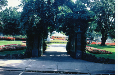
Photograph - Digital image - jpg, The Morey Gates, Ballarat Botanical Gardens
Colour photographmorey gates, ballarat botanical gardens, cuthbert house, floral and landscape gardening -
 Canterbury History Group
Book, Lemon, Andrew, The Master Gardener: T R Garnett of Marlborough College, Geelong Grammar School, The Age and The Garden of St Erth, 2018
Tommy Garnett (1915-2006), reforming headmaster of two famous schools, creator of the renowned Garden of St Erth, came late to his gardening and writing career. He penned his first newspaper article on his sixty-fifth birthday. Michael Davie, editor of The Age and The Observer, soon placed Garnett in the top rank of essayists, in the best traditions of English nature writers. Professor George Seddon saw him as one of Australia's most stimulating and provocative writers - honest, witty, profoundly knowledgeable, a truly enquiring mind. What was the life that shaped the garden and the writing? This closely researched and beautifully crafted biography explores the worlds that create the remarkable man who created The Garden of St Erth.632 pages; 32 unnumbered pages of. Includes family trees, plates : illustrations (some colour), portraits (some colour). Includes family trees, bibliography and index. Has dustcovernon-fictionTommy Garnett (1915-2006), reforming headmaster of two famous schools, creator of the renowned Garden of St Erth, came late to his gardening and writing career. He penned his first newspaper article on his sixty-fifth birthday. Michael Davie, editor of The Age and The Observer, soon placed Garnett in the top rank of essayists, in the best traditions of English nature writers. Professor George Seddon saw him as one of Australia's most stimulating and provocative writers - honest, witty, profoundly knowledgeable, a truly enquiring mind. What was the life that shaped the garden and the writing? This closely researched and beautifully crafted biography explores the worlds that create the remarkable man who created The Garden of St Erth.gardeners, school principals, geelong grammar school -
 Friends of Ballarat Botanical Gardens History Group
Work on paper - A Glowing Reference, John LINGHAM, letter from Council, City of Ballaarat, 1909, 5th March 1909
John Lingham was employed by the City of Ballaarat Council, in the Botanical Gardens, for over 30 years.John Lingham was a Curator of the Ballarat Botanic Gardens who worked with Guilfoyle and was a highly regarded consultant about other public gardens in Victoria. City of Ballarat logo, typed in the form of reference, signed by the Mayor and City Clerk with some dark shading left hand side.City of Ballarat seal in lower left hand corner.john garner collection, garner, dr, lingham, 1909, city of ballaarat, ballarat botanical gardens, ballarat, gardens, john lingham, floral and landscape gardening -
 Mont De Lancey
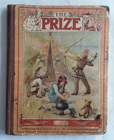
Book, Wells Gardner, Darton, & Co, Ltd, The Prize for Girls and Boys, 1918
A collection of varied stories and poems for young children - 1918 ed. There are practical articles as well, such as some on gardening.A yellow hardcover fiction book for children with a coloured picture of children playing a game of red indians outside a decorated teepee. The girl is cooking with a pot over an outdoor fire and the boys are firing a bow and arrow and painting a pot. The title, The Prize is printed at the at the top of the cover in red lettering surrounded by a boy and girl each side. Publisher details are at the bottom. The spine is brown tape. The back cover has a faded red advertisement for Pears Soap.There are advertisements on the endpapers at both front and back. There is foxing and tanning noted on the edges of the pages. There are stories and poems written by various authors and black and white illustrations and coloured plates throughout. The title page is very ornately decorated with a black and white floral design and covered by a tissue paper page. The coloured frontispiece is of three boys playing soldiers with one sitting on a rocking horse. There are Contents, Poetry and List of Illustrations pages. 164p.fictionA collection of varied stories and poems for young children - 1918 ed. There are practical articles as well, such as some on gardening.children's fiction, poetry -
 Mont De Lancey
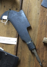
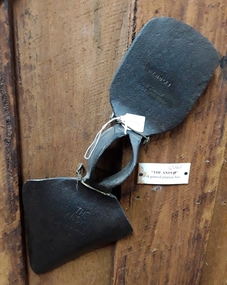
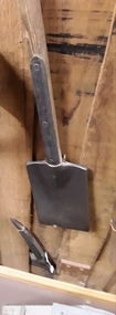
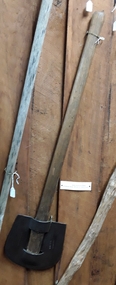
Tool - Bill Hook, Unknown
Used in the 19th centuryA bill hook or axe-handled slasher which is an axe-handled forged metal blade with a strong curved sharp axe like edge and a straight secondary edge on the back. It has a broken wooden handle with steel or a tang which passed through the handle if it were still attached. There is stamped on the blade near the handle join - '2'. The original finish of the blade would have been, 'Japanned' which is baked black enamel. It was used to cut back scrub, small trees and woody vegetation in the 19th century.'2' stamped on the blade near where it joins the handle.slashers, cutting tools, bill hook slasher, gardening tools, agricultural tools -
 Mont De Lancey
Tool - Hoe, Cornelius Whitehouse & Sons, Unknown
Used in the 19th Century'THE ANDYO' registered Hedgehog Tool. A forged steel head of a general purpose hoe with one side of the blade used as a hoe and the other pointed side possibly used to dig small furrows. It was made by Cornelius Whitehouse & Sons at Cannock Edge Tool Works - Branded Whitehouse & Sons. It was used in the 19th century.'THE ANDYO' is stamped on the pointed blade. On the hoe blade is stamped - Whitehouse & Sons CANNOCK. 'TY GWYN. agricultural tools, hoes, gardening tools, gardening hoes, steel -
 Mont De Lancey
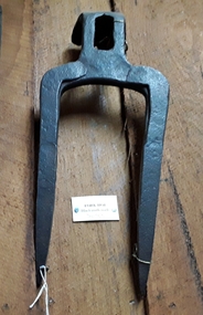
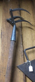
Tool - Fork Hoe, Unknown
Used in the 19th Century. A forged steel two pronged Forked Hoe head used to break up very hard or dry ground. There is a bend at the top of the fork with a hole for the handle. It was made by a blacksmith and used in the 19th century.agricultural tools, gardening tools, steel, pitchforks -
 Mont De Lancey
Tool - Hoe, Unknown
Used in the 19th Century A forged steel curved and straight blade headed hoe with a long handmade handle. It was used for chopping into the ground in the late 19th century.agricultural tools, hoes, gardening tools, gardening hoes, steel, wood -
 Mont De Lancey
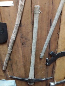
Tool - Pick, Unknown
Used in the 19th century.A forged steel pick with points at both ends mounted on a handmade wooden handle with a number 5 stamped on the head. It was used for loosening and breaking up compacted soil in the 19th or early 20th century.5picks, prying tools, agricultural tools, gardening tools -
 Mont De Lancey
Tool - Spade, Parkes & Co, Unknown
Used by Wandin Sebire for an unknown purpose.An unusual split headed long thin spade with a wooden handle Four rivets attach the head to the handle. At the top the handle is screwed to the metal. It was used by Wandin Sebire, probably for a special purpose - it is not known for what. Spades are usually used for turning soil by pushing against the blade with the foot. Used in the early 20th century.Stamped on the metal handle - '2' and 'S & C Ham'. 'Parkes & Co. Birmingham no. 2'.gardening spades, spades, shovels, gardening tools -
Mont De Lancey
Tool - Drainage Shovel, Unknown
Used by Wandin Sebire for an unknown purpose.A narrow goose necked drainage shovel with a very long wooden handle which was used to clean urban drains and prepare trenches for narrow pipes. A goose necked shovel is pulled towards the user by the very long handle. Used in the early 20th century.shovels, gardening tools, gardening equipment, tools, spades -
Mont De Lancey
Tool - Drainage Shovel, Unknown
A long swan necked steel scooped drainage shovel head with a long wooden handle, attached to the head by three rivets. It was used to prepare trenches for narrow pipe drains. A swan necked shovel is pushed away from the user by the very long handle. Used in the early 20th century.shovels, gardening tools, gardening equipment, tools, spades -
 Mont De Lancey
Tool - Scarifier
An adjustable metal headed hand scarifier with a wooden handle attached with a screw. It has nine teeth with the middle one lower, fixed and wider. It could be altered to suit the width of the row being worked. It was patented 1905.Patented 1905agricultural tools, agricultural equipment, tools, rakes, scarifiers, gardening tools, hand tools -
 Mont De Lancey
Tool - Scarifier, Unknown
A small combined hoe and rake metal headed hand scarifier or cultivator tool with a wooden handle. It has a pointed hoe shape at one end and at the opposite two hooked spikes. It could be used in small areas such as a garden.agricultural tools, tools, rakes, scarifiers, gardening tools, hand tools, hoes -
 Mont De Lancey
Tool - Hoe, Rake Head, Unknown
A small forged steel combined hoe and rake head hand cultivator tool. It has one flattened hoe shaped edge at one end and at the opposite, three rake prongs, and there is an extension on the head for the wooden handle to be attached. It could have been used in small areas such as a garden in the 19th century..agricultural tools, tools, rakes, gardening tools, hand tools, hoes -
 Mont De Lancey
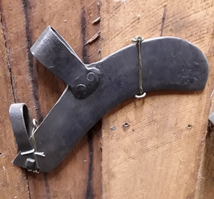
Tool, A & F PARKES & CO, Slasher, Unknown
A metal King Eye slasher with an unusual rounded 'U' shaped open blade and a wooden handle. On the blade is stamped, 'King Eye, PATT NO, 3868 A & F PARKES & CO BIRMINGHAM England'. It was efficient for clearing thin and dense low-lying scrub or bush where an axe would be too clumsy. It is similar to a billhook, but with a longer handle.'KING EYE, PATT NO, 3868 A & F PARKES & CO BIRMINGHAM ENGLAND'tools, agricultural equipment, agricultural tools, slashers, gardening tools -
 Mont De Lancey
Tool, Slasher, Unknown
Used by Wandin T Sebire.A thick curved forged steel scrub slasher - head only. It has two bent steel clamps to attach a handle, one which is small and is attached by a screw, the other large one is attached by two rivets. It was efficient for clearing thin and dense low-lying scrub or bush where an axe would be too clumsy. tools, agricultural equipment, agricultural tools, slashers, gardening tools -
 Mont De Lancey
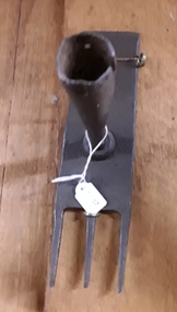
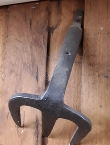
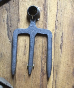
Tool - Fork Hoe, Unknown
A thick forged steel three pronged fork hoe head made by a blacksmith. There is a bent extension piece at the fork head where a handle can be attached.agricultural tools, gardening tools, hoes, gardening forks, handtools -
 Mont De Lancey
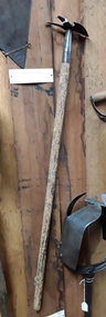
Tool - Bush Rake, Unknown
Used circa 1890.A blacksmith handmade bush rake with a steel head and a handmade long wooden handle which was roughly hewn from tea-tree wood. The head with 11 prongs is attached to the handle by a fork shaped steel fitted extension with three rivets. It was used to rake up debris after clearing land circa 1890.gardening tools, gardening rakes, rakes, gardening equipment, domestic equipment, tools -
 Mont De Lancey
Tool - Hay Fork, Unknown
Used late 19th and early 20th centuries.A blacksmith handmade hay fork or pitch fork with three thin forked metal spikes and a handmade long wooden handle. The head is attached to the handle with two rivets. It was used in the late 19th century and early 20th century.gardening tools, gardening equipment, domestic equipment, tools, gardening forks, pitchforks, agricultural equipment -
 Mont De Lancey
Tool - Scarifier, Unknown
It was used on well worked ground.A combined hoe and rake metal headed hand scarifier or cultivator tool with a long wooden handle. It has three curved metal hooks with sharp points and was used to break up the ground. It could be used in small areas such as a garden.agricultural tools, tools, rakes, scarifiers, gardening tools, hand tools, hoes -
 Mont De Lancey
Tool - Fork Hoe, Unknown
A thick forged steel three pronged fork hoe head made by a blacksmith. There is a hole at the fork head where a handle can be attached.agricultural tools, gardening tools, hoes, gardening forks, handtools -
 Mont De Lancey
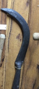
Tool, Slasher, Unknown
A handmade slasher with a long wooden handle and a heavy sharp steel blade attached with a rivet to the handle. It was efficient for clearing thin and dense low-lying scrub or bush where an axe would be too clumsy. Indiscernable inscriptiontools, agricultural equipment, agricultural tools, slashers, gardening tools -
 Mont De Lancey
Tool, Slasher, Unknown
A hand slasher with a long wooden handle and a heavy sharp steel rectangular blade attached with rivets to the handle. It was efficient for clearing thin and dense low-lying scrub, ferns or bush where an axe would be too clumsy. '232205' is stamped on the flat blade but the writing is Indiscernible. tools, agricultural equipment, agricultural tools, slashers, gardening tools -
 City of Kingston
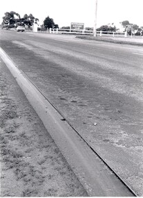
Photograph - Black and white, c. 1970
This photograph depicts the steel tramway (or tram plate) along Centre Dandenong Road, Cheltenham near the Moorabbin Airport entrance in the 1970's. These tramways played an important role in transportation along Moorabbin's major roads. Heavily laden carts could travel smoothly and safely along the steel plates when the road surfaces were often rutted and hazardous. This surviving section was later moved for road improvements. The area now known as the City of Kingston was a market garden region and the round trip to market could take as long as eight hours on poorly maintained roads. The installation of the steel tramway transformed the arduous journey faced by market gardeners in transporting their produce to market. As there was only a single tramway, the carts often travelled in convoy, enabling drivers to leave piloting to the first cart and having a rest. The rails did not speed the journey to the city, but it smoothed progress immeasurably. Black and white photograph of steel tram plates on Centre Dandenong Road, Cheltenham. The road is sealed. At the top of the image there are trees behind a parked car which is adjacent to a white shelter. There is a large sign stating MOORABBIN AIRPORT above an arrow pointing to the right in the top centre of the image. Handwritten in pencil: A 28 / [indecipherable] 3 / [indecipherable] Handwritten in red ink: A28 / 70%market gardening, infrastructure, transport, steel tramway, industry, moorabbin -
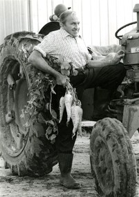 City of Kingston
Photograph - Black and white, Moorabbin News, 1963
Francis (Frank) Wilbur Le Page was mayor of Moorabbin between 1980 - 1981, and again in 1984 - 1985. He was a lifelong resident of the region and also a third generation market gardener.In approximately 1854, Nicholas Le Page moved his family from Prahran to Cheltenham. Two years earlier, they had arrived in Melbourne from Guernsey Island. Nicholas Le Page was a tailor and his wife was a dressmaker. They decided to move into market gardening instead. Their son, Everest, married Lynda and Francis Wilbur Le Page was born in 1919. He attended Cheltenham State School where he completed his Merit Certificate in grade eight before studying bookkeeping, shorthand and typing at Bradshaw and Everett Business College in South Melbourne. Both Frank’s grandfather and father were active in local government. Francis Thomas Le Page was a councillor for 25 years and served a term as shire president in 1902. Everest, his son, was a councillor for the City of Moorabbin for 28 years and was mayor on two occasions. Frank also served two terms as mayor, first in 1980 and again in 1984. Frank died on 14 July 2008.Black and white photograph of Frank Le Page stepping down from a tractor, with a bunch of parsnips in his right hand.Pink coloured paper adhered to reverse with black printed text and handwritten text in blue ink: STANDARD NEWS / Paper MOOR / Catchline Garden / Percentage 88% / Date 17-10-84 / Page 23le page, market gardens, tractor, moorabbin -
 City of Kingston
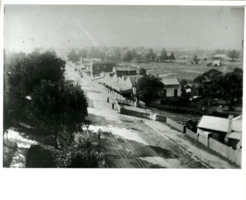
Photograph - Black and white, Percy Fairlam, c. 1910
Black and white image of Cheltenham in the early 20th Century depicts an almost idyllic life. This photo was taken by Percy Fairlam, who climbed a tall pine tree to achieve the aerial view. The tree was a well recognised feature of the Cheltenham skyline but was cut down some time before World War II.Cheltenham was established as a rural market gardening community. The development of the railway was crucial to the ongoing development of the area. Community life sprung up around the railway line which is evident in the proximity of shopping and leisure.Black and white image depicting aerial view down Charman Road, Cheltenham, including the unsealed road, level crossing and shopping centre. What appears to be a cricket pitch is located behind the shops.Handwritten in black ink on a red round sticker adhered to the reverse, and then crossed out: X14 Handwritten in blue ink on reverse: A8 Handwritten in red ink on reverse: 85%cheltenham, railway crossing, roads, housing, shopping strip -
 City of Kingston
Photograph - Black and white, 20 December 1945
This aerial photograph depicts the changing landscape of Cheltenham and Highett since WWII. Photographed in 1945, there is a mix of urban dwellings and industrial development and precedes the major transformation of Cheltenham with the development of the Southland shopping centre in the 1960s and expansion in the 1990s.A large part of Cheltenham was originally established as a rural market gardening community. The railway line and station brought urban development to the area and in the north, the Highett area was dominated by the Highett Gas Works. Cheltenham became a major destination for shopping in the 1960s with the opening of Southland.Aerial photograph taken in 1945 of Cheltenham and Highett within the City of Kingston. The image includes the Highett Reserve, (top right), the Methodist Children Homes (now Southland), Nepean Highway and Jamieson Street. Highett Gas Works is visible in the top left and the land now named William Fry Reserve at the intersection of Bay Road and Nepean Highway. A visible large parcel of land on the corner of Bay Road and Nepean Highway was developed in the 1990s as the west side addition to Southland. The densely vegetated area in the upper right sector of the image is now dense with housing. Tulip Grove, Heather Grove and Gilford Street are visible bottom left. This image is possibly from the collection of aerial photographs commissioned by the Department of Crown Lands and Survey and taken by Adastra Airways.Black ink: 57252 White lettering: VIC-10 57252 20.12.45 [lens information indecipherable] PROJ. No.5 MELB. METROP AREA Black pencil: 80highett, cheltenham, highett gas works, urbanisation -
 City of Kingston
Photograph - Black and white, 20 December 1945
This aerial photograph depicts the changing landscape of Cheltenham and Highett since WWII. Photographed in 1945, there is a mix of urban dwellings and industrial development and precedes the major transformation of Cheltenham with the development of the Southland shopping centre in the 1960s and expansion in the 1990s.A large part of Cheltenham was originally established as a rural market gardening community. The railway line and station brought urban development to the area and in the north, the Highett area was dominated by the Highett Gas Works. Cheltenham became a major destination for shopping in the 1960s with the opening of Southland.Aerial photograph taken in 1945 of Cheltenham and Highett within the City of Kingston. The image includes the Highett Reserve, (top right), the Methodist Children Homes (now Southland), Nepean Highway and Jamieson Street. Highett Gas Works is visible in the top left and the land now named William Fry Reserve at the intersection of Bay Road and Nepean Highway. A visible large parcel of land on the corner of Bay Road and Nepean Highway was developed in the 1990s as the west side addition to Southland. The densely vegetated area in the upper right sector of the image is now dense with housing. Tulip Grove, Heather Grove and Gilford Street are visible bottom left. This image is possibly from the collection of aerial photographs commissioned by the Department of Crown Lands and Survey and taken by Adastra Airways.Black type: Reverse lettering VIC-10 57252 20.12.45 [lens information indecipherable] PROJ. No.5 MELB. METROP AREA White lettering: Reverse writing 57252cheltenham, highett, highett gas works, urbanisation -
City of Kingston
Photograph - Black and white, 20 December 1945
This photograph depicts a section of Cheltenham with a mix of housing and market gardens. The visible market gardens, farms and paddocks have gradually been sub-divided into housing, commercial and industrial estates. A large part of Cheltenham was originally established as a rural market gardening community. The railway line and station brought urban development to the area and the gradual subdivision of farmland and large land holdings for the development of housing. Aerial photograph dated 1945 of the Cheltenham area in the City of Kingston. Sydney Street (bottom left); Sinclair Street (top left); Weymar Street area off Wilson Street, Charles Street (botton right).White print VIC-170; 57197; RUN5; PROJ.No.5; MELB.METROP AREA Lens information [indecipherable] Small photograph: clockface Black ink: 57197cheltenham, market gardens, urbanisation