Showing 30565 items
matching hill
-
 Whitehorse Historical Society Inc.
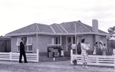
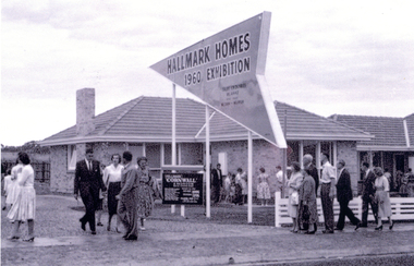
Photograph, 432 Springvale Road Forest Hill, 1960
Black & white photo of a brick veneer Display Home built by 'Hallmark' Homes at 432 Springvale Road Forest Hill.|See also NP3509-3514springvale road, forest hill, no. 432, aldag, ron, hallmark exhibition houses 1960, brick veneer -
 Whitehorse Historical Society Inc.
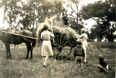
Photograph, Forest Hill Residential Kindergarten - stacking hay, c1938
See ND2991 for history of kindergarten.Sepia photograph of people stacking hay on a cart at the Forest Hill Residential Kindergarten. Two women with two children standing by with and a man standing on top of hay.forest hill residential kindergarten, kindergarten -
 Whitehorse Historical Society Inc.
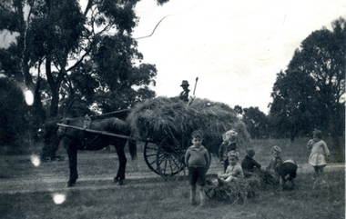
Photograph, Forest Hill Residential Kindergarten - cart full of hay, c1938
See ND2991 for history of kindergarten.Black & white photograph of a horse drawn cart full of hay with a man sitting on top. Six children in the foreground. taken at the Forest Hill Residential Kindergarten.forest hill residential kindergarten, kindergarten -
 Ringwood and District Historical Society
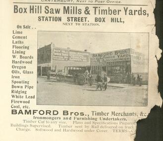
Document, Bamford Bros Timber Merchants, Box Hill SAw Mills & Timber Yards - Advertisement. Date Unknown
Advertisement for Bamford Bros Box Hill Timber Merchants &c. Date Unknown. Source unknown but originally scanned from a Victorian Business handbook of some type. ...Station Street Box Hill "Next to Station". Ironmongers and Furnishing Undertakers -
 Surrey Hills Historical Society Collection
Book, Box Hill, 1978
This book looks at Box Hill as it grew from a rural backwater to a country town amid farms and orchards, then to an outer suburb, and then to an almost inner suburb. It covers the rural depression in the 1860s, the land boom of the 1880s and the collapse in the 1890s, the bitter days of two World Wars and the Depression, and the 'dry' suburb of Box Hill.Hardback book of 270 pages, indexed and footnoted, with some photos and plans; it is divided into chronological periods rather than themes."SURREY HILLS / NEIGHBOURHOOD CENTRE - HISTORY" on top of title page; "Surrey Hills Neighbourhood Centre" on top of front of jacket.box hill, dry area, temperance movement, mayors, councillors, agriculture, railways -
 Latrobe Regional Gallery
Painting, BROWN, Joseph, Black Hill, 1998
Acrylic on canvasSigned and dated l.l. pencil "Joseph Brown 1998"hill -
 Federation University Historical Collection
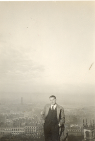
Photograph - black and white, Frank Wright at Calton Hill, Edinburgh, Scotland, 1933, 1933
Frank Wright was a renown resident of Smeaton, where he was born. He lived at Laura Villa, and attended Smeaton State School. His father William was a gold miner and his mother's name was Sarah. Their family won many singing and instrumental awards. Frank was tutored by Percy Code and was awarded a gold medal for the highest marks in the ALCM examinations in the British Colonies at the age of seventeen years. He became the Australian Open Cornet Champion by the age of eighteen. A year later, Frank conducted the City of Ballarat Band, and later the Ballarat Soldiers’ Memorial Band. He formed the Frank Wright Frisco Band and Frank Wright and his Coliseum Orchestra. These bands won many South Street awards, and Frank as conductor won many awards in the Australian Band Championship contest. In 1933 Frank Wright sailed to England to conduct the famous St Hilda’s Band and was later appointed Musical Director of the London County Council, where he organized many amazing concerts in parks, in and around the London district. He was made Professor of Brass and Military Band Scoring and conducted at the Guildhall of Music and Drama. Frank was often invited to adjudicate Brass Band Championships around Europe, in Australia, including South Street and in New Zealand. The Frank Wright Medal at the Royal South Street competition is awarded to an individual recognized as making an outstanding contribution to brass music in Australia.A black and white photograph of a man standing on a hill with a very foggy outlook over a large city. The man in the photograph is Frank Wright.Written on the reverse side of the photograph in pencil is "Frank Wright on Calton Hill Edinburgh 1933."frank wright,calton hill, edinburgh -
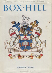
 Box Hill Historical Society
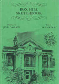
Book, Green, O. S.,Morant, Julia, Box Hill Sketchbook, 1978
Sketches of various houses and other significant landmarks in Box Hill with accompanying description. Drawings by Julia Morant. Contents; 56 pagesmachadodorp, pound house, whitehorse, town halls, libraries, houses, cemeteries, parks and gardens, box hill high school, burwood primary school, greek orthodox church, churches, blood's cottage, shops, shadmani, upton house, surrey dive, wattle park -
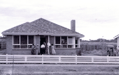
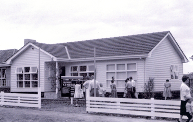 Whitehorse Historical Society Inc.
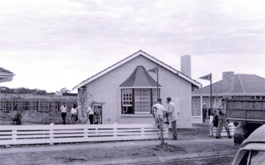
Photograph, 430 Springvale Road Forest Hill, 1960
Black & white photo of a brick veneer Display Home built by 'Hallmark' Homes at 430 Springvale Road Forest Hill.|See also NP3509-3513 &NP3516springvale road, forest hill, no. 430, aldag, ron, hallmark exhibition houses 1960, brick veneer -
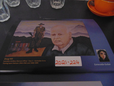 National Vietnam Veterans Museum (NVVM)
Painting, Doug Hill
An original painting of Warrant Office Class 2 Doug Hill in uniform in the background, also depicting the medal awarded for his service to the war. In the foreground is Doug Hill as a civilian in more recent timesDoug Hill, Australian Artillery Warrant Officer Class 2, Australian Army Training Team vietnam 1964-1965 and 1968-1969painting, vietnam lest we forget, aattv -
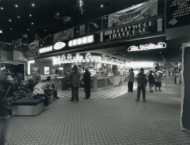 Whitehorse Historical Society Inc.
Photograph, Hoyts Theatre Complex, Forest Hill, 1994
Black and white photograph of the foyer at Hoyts Theatre Complex, Forest Hill Chase Shopping Centre- 1994. Two people standing in centre with ice cream sign overhead. hoyts theatre complex, forest hill -
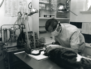 Whitehorse Historical Society Inc.
Photograph, Veterinary Practice, Forest Hill, 1994
Black and white photograph of a vet operating on a cat in a surgery at 357 Canterbury Road, Forest Hill. Cat is lying on a stainless steel bench. Vet with face mask. 1994veterinarians, veterinary services -
 Whitehorse Historical Society Inc.
Photograph, 424 Springvale Road Forest Hill, 1960
Black & white photo of a brick veneer Display Home built by 'Hallmark' Homes at 424 Springvale Road Forest Hill.|See also NP3509-3510 & NP3512-15.springvale road, forest hill, no. 424, aldag, ron, hallmark exhibition houses 1960, brick veneer -
 Whitehorse Historical Society Inc.
Photograph, 426 Springvale Road Forest Hill, 1960
Two black & white photos of a brick veneer Display Home built by 'Hallmark' Homes at 426Springvale Road Forest Hill.|See also NP3509-11 &NP3513-15springvale road, forest hill, no. 426, aldag, ron, hallmark exhibition houses 1960, brick veneer -
 Warrnambool and District Historical Society Inc.
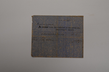
Document - Tower Hill Presbyterian Church Invoice, Committee of Tower Hill Presbyterian Church, 1871
This is an invoice sent to Messrs W.& J. Hall in September 1871 by the Committee of the Tower Hill Presbyterian Church. It refers to the annual church seat rental fee of three pounds, half of which had been paid in January of that year. The Tower Hill Presbyterian Church was under the auspices of the Koroit Presbyterian Church and services had been held in the Tower Hill area as early as 1845. The first permanent minister, Rev. Lachlan McGillivray. was appointed in 1849 and a wooden church was erected at Tower Hill in 1850. William and James Hall were early farmers in the Tower Hill district.This invoice is of considerable interest as a rare memento of the 19th century Tower Hill Presbyterian Church and a record of the practice of charging an annual fee for a family's use of its own pews in a church.This is a sheet of blue and cream mottled paper with ruled red lines, black printing and handwriting in ink. The sheet is creased, torn at the edges and faded.Messrs W. & J. Hall 30 Sept. 1871 An Account with the Committee of the Tower Hill Presbyterian Churchtower hill presbyterian church, w.& j. hall koroit -
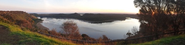
 Ballarat Heritage Services
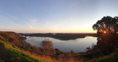
Photograph, Clare Gervasoni, Tower Hill Crater, 11/09/2020
Tower Hill is 18km west of Warrnambool and is accessed from the Princes Highway. Tower hill is a dormant volcano, with associated conical hills, large and small craters, basalt outcrops from lava flows and layers of Ash from long ago eruptions. Panorama of the crater at Tower Hilltower hill, crater, volcano -
 Ballarat Heritage Services
Photograph, Clare Gervasoni, Tower Hill Crater, 11/09/2020
Tower Hill is 18km west of Warrnambool and is accessed from the Princes Highway. Tower hill is a dormant volcano, with associated conical hills, large and small craters, basalt outcrops from lava flows and layers of Ash from long ago eruptions. Panorama of the crater at Tower Hilltower hill, crater, volcano -
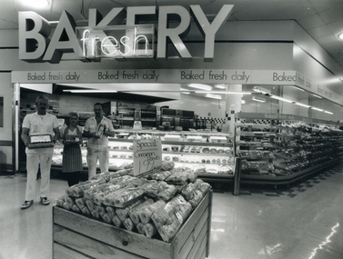 Whitehorse Historical Society Inc.
Photograph, Coles Supermarket, Forest Hill, 1994
Black and white photograph of the kitchen staff in the bakery section of Coles, Forest Hill Chase. Three staff on left are showing products. Wooden box containing cinnamon donuts in centrecoles supermarkets, forest hill chase, bakeries -
 Whitehorse Historical Society Inc.
Photograph, 428 Springvale Road Forest Hill, 1960
Two black & white photos of a brick veneer Display Home built by 'Hallmark' Homes at 428 Springvale Road Forest Hill.|See also NP3509-3512 &NP3514-+15springvale road, forest hill, no. 428, aldag, ron, hallmark exhibition houses 1960, brick veneer -
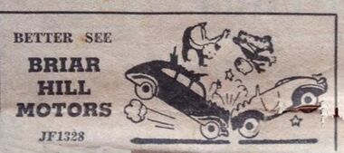 Greensborough Historical Society
Advertisement - Digital image, Briar Hill Motors, 1970s
Advertisement in the local paper for Briar Hill Motors, of Briar Hill 1970sPart of a collection of miscellaneous advertisements for businesses in Greensborough and surrounding areas.Digital copy of newspaper advertisement.briar hill motors -
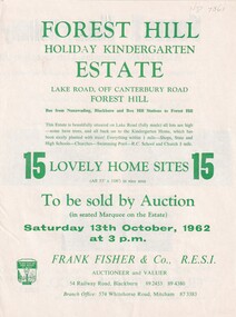 Whitehorse Historical Society Inc.
Document, Forest Hill Estate, 13/10/1962 12:00:00 AM
Fifteen home sites to be auctioned by Frank Fisher & Co. on 13 Oct 1962.Fifteen home sites to be auctioned by Frank Fisher & Co. on 13 Oct 1962 called Forest Hill Estate in Lake Road, Forest Hill.Fifteen home sites to be auctioned by Frank Fisher & Co. on 13 Oct 1962.forest hill estate, lake road, forest hill, frank fisher co. -
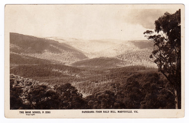 Marysville & District Historical Society
Postcard (item) - Black and white postcard, Rose Stereograph Company, Panorama From Bald Hill, Marysville, Vic, 1913-1967
A postcard in a series produced by the Rose Stereograph Company in Victoria, Australia as a souvenir of Marysville.A black and white postcard of a view of hills taken from Bald Hill near Marysville.THE ROSE SERIES, P. 2293/ Copyright/ PANORAMA FROM BALD HILL, MARYSVILLE, VIC. POST CARD PLACE POSTAGE/ STAMP/ HEREbald hill, marysville, victoria, p. 2293, rose series postcard, postcard, souvenir -
 Otway Districts Historical Society
Trophy, Otway Football Association, Premiers, 1938, Lavers Hill Imperials, c.1938
In 1938, the Otway Football Association initially comprised Beech Forest, Gellibrand, Wyelangta and Carlisle, but altered when Wyelangta and Johanna amalgamated to form Hill Imperials in May, 1938. In the grand final, Hill Imperials and Carlisle met, with Hill imperials emerging victors 13-4, 82 points, to Carlisle 7-15, 57 points, to become 1938 Premiers.Two-handled urn-shaped cup with knobbed lid. Square bakelite base added later.Otway Football; Association, Lavers Hill Imperials. Premiers 1938otway; football; lavers hill imperials; carlisle; -
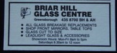 Greensborough Historical Society
Advertisement - Digital image, Briar Hill Glass, 1960s
Advertisement in the local paper for Briar Hill Glass, of 15 Sherbourne Road, Briar Hill 1970sPart of a collection of miscellaneous advertisements for businesses in Greensborough and surrounding areas.Digital copy of newspaper advertisement.briar hill glass centre, sherbourne road briar hill -
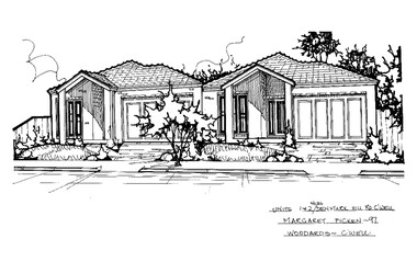 Camberwell Historical Society
Drawing (series) - Architectural drawing, 1+2/36 Denmark Hill Road, Camberwell, 1997
artist, architectural drawings, margaret picken, camberwell, housesartist, architectural drawings, margaret picken, camberwell, houses -
Phillip Island and District Historical Society Inc.
Book, Webster, M. S. (Mona Stuart), history of the Mont Albert shopping centre 1887-1985, 1986
mont albert shopping centre, history, victoria -
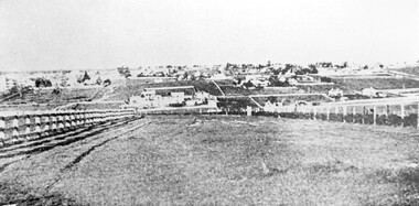 Surrey Hills Historical Society Collection
Photograph, Looking towards Box Hill from the site of the Surrey Hills Golf Club, 1902, 1902
Reproduced by permission of Mr John Arnold from his book: "The Riversdale Golf Club - a history, 1892-1977." Copyright to book: Riversdale Golf Club. Surrey Hills Golf Club operated from 1892-1908 then moved and became Riversdale Golf Club. The game was played across paddocks from Trafalgar Street, Mont Albert to Whitehorse Road and down Victoria Crescent to where Box Hill TAFE is now located in Elgar Road. There were problems with cows eating the tee flags! The clubhouse still exists as 30 Trafalgar Street.Black and white photo with a large grassy paddock in the foreground. From the bottom left and right post-and-rail fences converge on a group of large industrial buildings in the centre middle distance. In the background are paddocks and buildings."Top: Looking towards Box Hill from the links in 1902. The old Box Hill Gas Works is in the centre of the picture."sports grounds, surrey hills golf club, riversdale golf club, box hill gas works, gasworks, public utilities, gas -
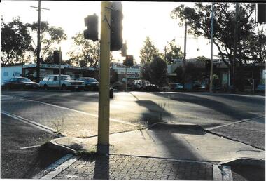 Greensborough Historical Society
Photograph, Ian Bennetts, Briar Hill Shops 1990.1, 1990_
Briar Hill shops, corner Mountainview Road and Sherbourne Road.Photographs taken in 1990, many businesses have changed but the buildings remain in 2019.Colour photograph"Briar Hill shops 1990" (photo taken by Ian Bennetts)briar hill, mountainview road briar hill, sherbourne road briar hill -
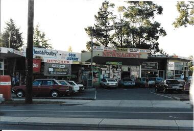 Greensborough Historical Society
Photograph, Ian Bennetts, Briar Hill Shops 1990.2, 1990_
Briar Hill shops, corner Mountainview Road and Sherbourne Road.Photographs taken in 1990, many businesses have changed but the buildings remain in 2019.Colour photograph"Briar Hill shops 1990 (photo taken by Ian Bennetts)"briar hill, mountainview road briar hill, sherbourne road briar hill -
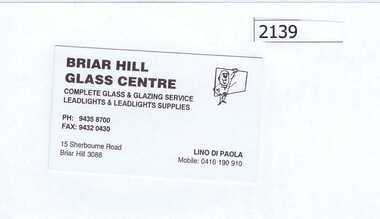 Greensborough Historical Society
Business card, Briar Hill Glass Centre, 2010_
Business card of Lino di Paola, Briar Hill Glass Centre, 15 Sherbourne Road Briar Hill 3088. Business closed c. 2011.Business card, black print on white card. briar hill glass centre, lino di paola