Showing 10909 items matching " plans "
-
 Mission to Seafarers Victoria
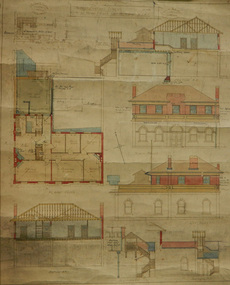
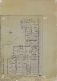
Plan - Architectural drawings, Walter Butler, 1916
... plans ...An original group of plans drawn by Walter Butler who was also the architect of the Central Institute, Siddeley Street in 1906 and the Mission to Seamen building at 717 Flinders St that is still in use today. The early Port Melbourne onshore Mission gradually transformed from a 'wooden shack' to a one storey brick building designed by architect Frederick Williams in 1888. The St Nicholas chapel was added in 1915. Walter Butler was commissioned to add a second storey in 1917. The building retained its functions until 1937 when the Art Deco Mission, designed by Morris was built. The building has survived as a structure into the 21st century, and was incorporated as part of a multi-apartment development. Historical architectural record of Walter Butler's work. Walter Butler was a renowned architect and friend of the Fairfax family.Coloured architect's drawings of the proposed plans for Chaplain's Residence at Port Melbourne on heavy parchment. Including elevation drawings, floor plans and cross sections as well as architect's notes and measurements.Embossed architect's stamp in top right and left corners and bottom right corner "Walter R Butler [indecipherable] Melbourne" Printer's stamp on bottom right hand corner of rear "Printed by J. Creffield Propy. LTD. RIALTO, 493-5 Collins St. Melbourne"plans, walter richmond butler (1864–1949), mission to seafarers, chaplains residence, beach street, nott street, port melbourne, mission to seamen, frederick williams -
 Bacchus Marsh & District Historical Society
Map, Limestone Reserve Parish of Merrimu 1888
Limestone deposits in the Coimadai area 10 kilometers north of Ballarat were first worked in the 1850s. The area was quarried for limestone for many years by various people and companies. The surveyor's name who produced this plan is inscribed on the map and below this is the name P. L. Alkemade, who presumably paid for the map to be produced. In 1886 Petrus Alkemade in partnership with Matthew Egan established the Alkemade Hydraulic Lime and Cement Company. The Alkemade family were involved in the limestone industry over several generations at Coimadai.Single page map showing part of the Limestone reserve near Coimadai in the Parish of Merrimu. Scale 4 chains to 1 inch. Part of a set of maps which are pasted into a bound volume containing 76 maps or plans in total. High resolution digital image stored on BMDHS computer network. Copy of plan surveyed by Mr. G? [illegible] an authorised surveyor on 17th July 1888. P. L. Alkemadebacchus marsh victoria maps, lime kilns coimadai, limestone, coimadai victoria maps, alkemade family coimadai -
 Ringwood and District Historical Society
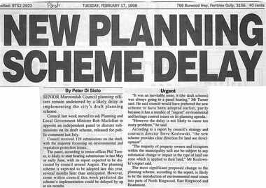
Newspaper, Scrapbook Clipping, Library Collection, Ringwood, Victoria, `
``Newspaper clipping from the "Post", Tuesday February 17, 1998. NEW PLANNING SCHEME DELAY. By Peter Di SistoSenior Maroondah Council planning officers remain undeterred.by a likely delay in implementing the city's draft planning scheme. Council last week moved to ask Planning and Local Government Minister Rob Maclellan to appoint an independent panel to discuss submissions on its draft scheme, released for public comment last July. ` -
 Glenelg Shire Council Cultural Collection
Plan - Port of Portland Authority Marine Department Depot Site Layout and Groundworks, 29/09/1988
... Plans ...port of portland, port of portland authority archives, plans -
 Whitehorse Historical Society Inc.
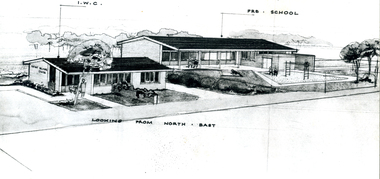
Photograph - B/W Photograph, East Burwood Infant Centre
... Plans ...Black and white photo of East Burwood Infant Centre and Pre-School -planeast burwood infant welfare centre, east burwood preschool, plans -
Stawell Historical Society Inc
Map, Shire of Stawell, Shire of Stawell Interim development Order, C 1930
Planning MapColoured Map of Stawell Shire showing Zoning AreasGuttering Haskings & Davey Pty Ltd Division of Urban and Environmental Planninglocal development -
Clunes Museum
Drawing, ALF LOWTHER, CRUSHING WORKS PORT PHILLIP COMPANY, UNKNOWN
... PLANS ...PHOTOCOPY OF A DRAWING OF THE CRUSHING WORKS OF THE PORT PHILLIP COMPANY, CLUNESON REVERSE: HANDWRITTEN ON REVERSE OF PLAND "PORT PHILLIP MINE, PHOTOCOPY OF DRAWINS ALF LOWTHER BENDIGO" PRINTED ON FRONT PLAN L812port phillip mine, plans, crushing works -
 University of Melbourne, Burnley Campus Archives
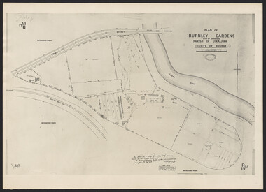
Photograph - Plan of Burnley Gardens
"This plan is a copy of a copy of the survey made by Mr. Turner in 1926. The original plan and field notes are missing _ file Rs 3529" Signed by _signature unreadable_ -
Glenelg Shire Council Cultural Collection
Photograph - Photograph - Portland Harbour Development, n.d
Port of Portland Authority ArchivesFront: Black & white Photograph of a plan showing proposed changes to the Fisherman's Breakwater area of the Port of Portlandport of portland archives, port of portland -
Clunes Museum
Document - PLAN, JOHN RUTHERFORD, CLUNES KNITTING AND MANUFACTURING COMPANY
... PLANS ...PLAN & GENERAL ARRANGEMENT FOR THE CLUNES KNITTING AND MANUFACTURING CO. LTD. local history, documnts, plans, knitting mill interknit hosiey co. -
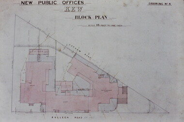 Kew Historical Society Inc
Slide - Architectural Drawing, Kew Public Offices, 1887
A civic campaign for new public offices developed in Kew in the 1880s. After much deliberation, the location chosen was the junction of Bulleen and Cotham Roads. The buildings were designed by George Watson and John Henry Harvey, architects within the Department of Public Works (Victoria). Building was commenced in 1887, and after one year, the buildings were opened. The Post Office was transferred to the new Commonwealth Government in 1901. The Police Station and Court House, sold by the Victorian Government to the City of Boroondara in 2007, are now a community cultural centre and performing arts venue.The buildings were listed on the Victorian Heritage Register Register (HO885) in 1991. They are historically and architecturally significant to the State Of Victoria because Watson and Harvey's designs exhibit diversity in integrating civil offices, they accommodate the apex of road junctions, and they demonstrate a departure from the contemporaneously favoured High Victorian Classical to the Queen Anne style in the design of civic buildings. 35mm colour transparency of an original plan by George Watson and John Henry Harvey, architects of the Department of Public Works (Victoria), in 1887 for New Public Offices at Kew. This plan was copied by the donor from an original held at the Commonwealth Archives in Brighton (Vic). The copy was made to illustrate a report that the donor made on ‘The functional planning design, building materials and construction methods of the Kew Post Office’ as part of course work at RMIT.NEW PUBLIC OFFICES KEW / BLOCK PLAN / SCALE 16 FEET TO ONE INCH / DRAWING NO 4kew court house, kew police station, kew post office, architectural drawings, khs - slides, new public offices — kew (vic.), architecture — queen anne style -
Clunes Museum
Plan - PLANS CLUNES CARAVAN PARK, NO. 1 - SHIRE OF TALBOT & CLUNES. IAN MANSLEY, SHIRE ENGINEER NO. 2 - LEO MCMAHON & ASSOCIATES PTY. LTD. LICENSED SURVEYORS & ENGINEERS, 31 LYONS ST. NTH. BALLARAT, 1976
... PLANS ...NO. 1 PLAN - CLUNES CARAVAN PARK ENGINEER - IAN MANLEY NO. 2 PLAN - SECTION 15 TOWNSHIP OF CLUNES, COUNTY OF TALBOT, BY LEO MCMAHON AND ASSOCIATES, LICENSED SURVEYORS AND CIVIL ENGINEERSplans, caravan park, ian manley, plan section 15 -
Clunes Museum
Plan, Varley Bros, Proposed Turbine Creamery, 1894
... plans ...Hand drawn plan on paperHandwritten in black ink: "These are the drawings referred to in our tender dated 7th September '94 for erection of creamery building at Glendaruel J Acrow *& Co. Contractorcreamery, turbines, plans, glendaruel, j bartram & son, varley bros -
Federation University Historical Collection
Plan, Barkly Street Campus, Ballarat East, c1950s ?
... plans ...Ink on paper plan: Barkly Street Campus. plans, barkly street campus, ballarat east, ballarat girls', ballarat girls' secondary school -
 Federation University Historical Collection
Plan, Berry Bank Estates
This plan is associated with former Ballarat School of Mines Student Richard Squire (1875-1876). Gift of the Squire FamilyPlan of Berry Bank Estates. Coloured plan on cream paperberry bank estates, mining, happy valley, lake rosine estates, strathvean estates proprietary, w. luplaupitfield plateau, british banner, federal mint, moller, morrow, south pitfield consols, east banner, new lallah rookh, bull dog company, mindai, j. morpoh, poliah, f. j. morrow, piggoreet east, w. m. acheson, grand trunk, field's claim south grand trunk, south grand trunk, woady yalloak creek, mount misery creek, fitzpatric's creek, illabrook creek, great western, mount bute syndicate, narringhill creek, little woady yalloak creek, piggoreet east preemptive right, southern birthday, new birthday, prince of wales, collins, brassey birthday, howarth's lead, w. price, royal birthday, a. clinton, victoria express, patons, williams fancy, hennessy, queen of the south, n, pandora proprietary gold estate, lyonbank lease, rowe's southern, rowe's extended, w. t. rowe, wallinduc company, glenfine horseshoe company, rowe's glenfine junction, wallinduc syndicate, pitfield estates, rowe's estate, southern glenfine, h. fields, christies & fields, balmoral company, glenfine united, hallett, great glenfine, rowe consuls, nicholls, london & melbourne gold mine, j. w. pascoe, christies, glenfine central, j. king, j. durston, great western extended, oswald, woadyyaloak, berringa, squire -
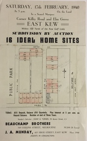 Kew Historical Society Inc
Plan - Subdivision Plan, Subdivision by Auction: 16 Ideal Home Sites, East Kew, 1940, 1940
An advertisement for the sale of a subdivision by Auction: of 16 Ideal Home Sites, East Kew, 1940. This significant sale of land between the Kew Golf Course and Willsmere Park led to the streets having a high degree of architectural uniformity.The subdivision in the second year of the war indicates that land sales for homes and speculation continued from the 1930s into the period of the Second World War. There is no indication on the plan that a war is occurring.Single page subdivision plan advertising the sale by Auction of 16 Ideal Home Sites, in East Kew, on 17 February 1940. Streets named in the plan include: Kilby Road, Belford Road, Elm Grove, Willow Grove. Willsmere Park is indicated but not named. The auction was conducted by Beauchamp Brothers. A number of lots are coloured pink on the plan indicating those lots for sale and/or those already sold.subdivision plans - kew east (vic) -
 Greensborough Historical Society
Planning Document, Banyule City Council, Site plan of Greensborough 1997, 28/07/1997
Site plans for the area bounded by Flintoff Street; Grimshaw Street; Main Street and Para Road Greensborough. these plans show the area before the development of Watermarc.This plan shows central Greensborough before the Watermarc developmentSet of 8 site plansgreensborough, greensborough swimming pool -
 Whitehorse Historical Society Inc.
Photograph, Auction Plan of Eastdawn Estate, Mitcham, 1915
... plans ...Black and white strip photo of Auction Plan of Eastdawn Estate, Mitcham Road and Orient Avenue, Mitcham.auctions, plans, eastdawn estate -
 Bendigo Historical Society Inc.
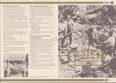
Document - CENTRAL GOLDFIELDS RESTORATION FUND, March 1986
Pamphlet on the Central Goldfields Restoration Fund issued by the Victorian Ministry for Planning and Environment. Includes a map of the central goldfields region, introduction by Jim Kennan (Minister) and 3 photographs. Also a description on how the fund operates and how to apply for assistance. An insert of 2 blank application forms. Photos show , Miners using a sluice at Tarnagulla c.1880. Cnr of Sturt and Lydiard Sts, Ballarat c.1880. E. Eberhard Cordial Factory at Clunes c.1890.Victorian Ministry for Planning and Environmentorganization, government, central goldfields, restoration fund, ministry for planning and environment, j. kennan, tarnagulla, ballarat, clunes. -
Whitehorse Historical Society Inc.
Map, Blackburn East Primary School
Plans of Blackburn East Primary SchoolPlans of Blackburn East Primary School (1)1957; (2) Master Plan ; (3) Master Plan 1973. (4) Scheme F: Staff and administrative facilities 1974, Scale 1/8:1'Plans of Blackburn East Primary Schoolblackburn east primary school no. 4800, master plan, admin facilities -
 Warrnambool and District Historical Society Inc.
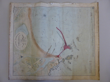
Map, Warrnambool Harbour 1879, 1879
This map shows the plans by eminent harbour engineer, Sir John Coode in 1879. Construction of the breakwater commenced in 1884 and was completed in 1890. Coode first visited Australia in 1872 when he commenced work with the Melbourne Harbour Trust to report on ways to improve Melbourne Port. He is considered one of the most eminent harbour engineers of the 19th century. His original plans for Warrnambool were revised because of cost but then subsequently found to be inadequate and later extended. This was not successful either and the harbour continues to have silting problems to this day. The Warrnambool Breakwater is of historical importance to Victoria and as this map depicts the original plans, it too has great historical significance. It is also significant with its association with Sir John Coode, who was one of the most important port engineers of the 19th century. He worked to improve ports along the Victorian coast including Portland, Geelong, Port Fairy and Lakes Entrance. While this map demonstrates the engineering skills of the era, it also reflects the limitations when natural elements are involved. Its Historical importance also lies in the depiction of items on the map which relate to Warrnambool’s early history. Paper on linen map coloured, and depicting the harbour area of Warrnambool with the proposed breakwater plan in red. It has Victorian Harbours information in oval at top of map. It shows depths of some areas.In oval at top, “Victorian Harbours Warrnambool plan to accompany Sir John Coode report dated 28th Feb 1879. Drawing No 2. Scale 500 feet to 1 inch at bottom centre. Sir John Coode signature in bottom left corner. A 33 A on bottom left reversesir john goode, warrnambool harbour map, warrnambool harbour map 1879, port of warrnambool map 1879 -
![Map, [Plan for road to give J. Allan access to permanent water at Coimadai] circa 1870s](/media/collectors/5e461d8021ea67224c82f2a1/items/67735190d671e67dd573a84c/item-media/6773533dd671e67dd573cd90/item-fit-380x285.jpg) Bacchus Marsh & District Historical Society
Bacchus Marsh & District Historical SocietyMap, [Plan for road to give J. Allan access to permanent water at Coimadai] circa 1870s
The date of this map or plan is uncertain but it appears to be from the early to mid 1870s. One of the landholders identified on the plan, James Allan of Coimadai died suddenly on the 9th July, 1874 (see Bacchus Marsh Express, 11 July, 1874, page. 3). There are mentions of an Allans Road at Coimadai in the Bacchus Marsh Express between 1887 and 1942.Single page map showing an excision of land belonging to Charles Ross which was selected to construct a road to give another landholder, J. Allan access to permanent water. Scale 1 chain to 1 inch. Part of a set of maps which are pasted into a bound volume containing 76 maps or plans in total. High resolution digital image stored on BMDHS computer network. Plan showing Excisions from Ross's selection and 1 chain road thro' the said selection in Coimadai to give J. Allan access to permanent water. Alistair ?? Shire Eng? 6?/5/7?coimadai victoria maps, coimadai roads and streets -
 Greensborough Historical Society
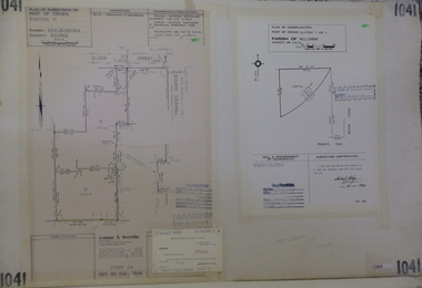
Planning Document, Subdivision Plan #1041. Elder Street Greensborough, 20/04/1983
Plan of Consolidation of Allotments 3 and 4 Brixton Avenue and Plan of Subdivision for Elder Street. An example of hard copy subdivision plans from the Greensborough area. Mainly from the Shire of Diamond Valley era (1964-1994).Plan (2 sheets) mounted on heavy card.Stamped and handwritten Council permissions, dates and other details.subdivision plans, elder street, brixton avenue -
Federation University Historical Collection
Plan, Ballarat School of Mines New Workshops Hotwater Supply, 1941, 1941
... plans ...Service plan for new workshops at the Ballarat School of Mines.ballarat school of mines, new workshops, buildings, hotwater service, plans -
 Federation University Historical Collection
Plan, Ballarat School of Mines New Workshops, Albert Street, 1944
... plans ...The Ballarat School of Mines is the first School of Mines in Australia, and was established in 1870.Black ink on paper plan: SMB New Workshops plans, smb workshops, percy everett, smb, ballarat school of mines -
Clunes Museum
Document - PLAN, ADAMS FREEHOLD AND ADJACENT MINING PROPERTIES
... PLANS ...PLAN SHOWING ADAM'S FREEHOLD AND ADJACENT MINING PROPERTIES.J.WEARElocal history, document, mine plan, mining, plans -
Port Melbourne Historical & Preservation Society
Plan - Street levels, c. 1862
Drawn up to replace rescinded portions of street plan of March 1862.Plan of street levelsDetails and signatures as belowengineering - roads streets lanes and footpaths, frederick william bull, thomas swallow, edward clark, town clerks -
 Glenelg Shire Council Cultural Collection
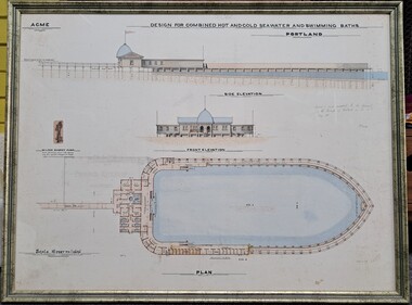
Drawing, ACME, Design for Combined Hot and Cold Seawater and Swimming Baths - Portland, c. 1888
Drawing/plan showing the design for the Portland Seabaths. At the top of the plans is the side elevation titled underneath, below is the front elevation and at the bottom the whole plan from the top. The scale is 16 feet to 1 inch. There is also an image of the Wilson Donkey Pump.Top Left - ACME Design for Combined Hot and Cold Seawater and Swimming Baths / Portland In handwriting to the right of the plan ' Agreed to and adopted by the Council of the Borough of Portland on the 30th May 1888'portland sea baths, seawater baths, acme, design, plan -
 Kew Historical Society Inc
Slide - Architectural Drawing, Kew Public Offices, 1887
A civic campaign for new public offices developed in Kew in the 1880s. After much deliberation, the location chosen was the junction of Bulleen and Cotham Roads. The buildings were designed by George Watson and John Henry Harvey, architects within the Department of Public Works (Victoria). Building was commenced in 1887, and after one year, the buildings were opened. The Post Office was transferred to the new Commonwealth Government in 1901. The Police Station and Court House, sold by the Victorian Government to the City of Boroondara in 2007, are now a community cultural centre and performing arts venue.The buildings were listed on the Victorian Heritage Register Register (HO885) in 1991. They are historically and architecturally significant to the State Of Victoria because Watson and Harvey's designs exhibit diversity in integrating civil offices, they accommodate the apex of road junctions, and they demonstrate a departure from the contemporaneously favoured High Victorian Classical to the Queen Anne style in the design of civic buildings. 35mm colour transparency of an original plan by George Watson and John Henry Harvey, architects of the Department of Public Works (Victoria), in 1887 for New Public Offices at Kew. This plan was copied by the donor from an original held at the Commonwealth Archives in Brighton (Vic). The copy was made to illustrate a report that the donor made on ‘The functional planning design, building materials and construction methods of the Kew Post Office’ as part of course work at RMIT.NEW PUBLIC OFFICES KEW/ FIRST FLOOR & ROOF PLAN / DRAWING NO 1 / SCALE 8 FEET TO ONE INCHkew court house, kew police station, kew post office, architectural drawings, khs - slides, new public offices -- kew (vic.), architecture — queen anne style -
Stawell Historical Society Inc
Map, Underground Mine Workings Stawell, 1894
... Plans ...Plan and Elevations of mine workings 12 September 1894. J H Bate Mining Surveyor. Framed under Glassstawell, mining, plans