Showing 444 items
matching quartz mining
-
 Wodonga & District Historical Society Inc
Photograph - North-Eastern Gold Days, 1900
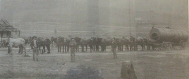
Bethanga was established as a result of the discovery of gold. Gold was first reported in the Bethanga area in 1852. Before 1876 gold mining in the Bethanga district occurred to the north of the town and was known as the 'Talgarno diggings'. Reports of alluvial gold date back to 1852. Early gold fields were worked at Ruby Creek, Gold Creek and Jarvis Creek. The opening of the Bethanga goldfields began with the discovery of a gold-bearing quartz reef on New Year’s Day 1876. The 'Gift' mine site is located southeast of Kurrajong Gap lookout to the west of Bethanga township. The Great Eastern Copper Smelting Works was opened in 1878. Due to the nature of the gold-bearing quartz reef, the gold was difficult to extract, and the discovery of copper led to a change in focus. It was not until the early 1890s that an efficient technique for extracting the gold from the ore was discovered, and once again gold became the focus, with copper as a by-product. Bethanga was removed from the official list of goldfields in 1912, however some mining activity has taken place since.This image reflects an important time in the development of Bethanga and Northeast Victoria.A large mounted and framed image of horse teams and their owners hauling a large boiler to the gold mine near Bethanga, Victoria. On label beneath image: "North-eastern "Gold Days"/ Combined teams hauling a boiler to Bethanga Mines, 1900. Teamsters - Mr. G. Pearce, W. Chapple, G, Bannon." Donated by Ron Saunders and Barbara Cadman"bethanga, gold mining northeast victoria, gold mining bethanga, bethanga history -
 Wodonga & District Historical Society Inc
Book - Secrets of Ghost Towns of the Mountain Goldfields, Luke Steenhuis, 1999
Stories from 50 former towns in and around Melbourne's North-east mountain region. These old towns include: Aberfeldy, Aberfeldy Crossing, BB Township, Blue Jacket, Clarke's Flat, Concord Gully, Edwards Reef, Fultons Creek, Jericho, Loch Fyne, Red Jacket, Store Point, The Springs, Toombon, Toombon Upper, Tullamore, Upper Thomson, Victors Quartz, Violet Town & White Star.non-fictionStories from 50 former towns in and around Melbourne's North-east mountain region. These old towns include: Aberfeldy, Aberfeldy Crossing, BB Township, Blue Jacket, Clarke's Flat, Concord Gully, Edwards Reef, Fultons Creek, Jericho, Loch Fyne, Red Jacket, Store Point, The Springs, Toombon, Toombon Upper, Tullamore, Upper Thomson, Victors Quartz, Violet Town & White Star.ghost towns victoria, gold mining victoria -
 Bendigo Historical Society Inc.
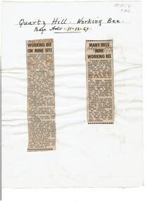
Newspaper - Quartz Hill Working Bee, 1967
Quartz Hill is situated on the Sheephead line of reef and is situated just south of where the Red, White and Blue Consolidated Gold Mine operated. Two newspaper cuttings affixed to lemon backing sheet. Written on top in black pen: 'Quartz Hill Working Bee, Bdgo Adv. 11.12.67' Cutting one, 'Working Bee on Mine Site' with 7.12.67 written across the top, describes an appeal to get volunteers to clear the site of former mines on Quartz Hill. This is anticipated to 'clear the site of accumulated debris and clean out the two large adits driven into the hill and thus make the site a 'tourist visiting spot'. Cutting two, 'Many Miss Mine Working Bee' dated 11.12.67, describes the poor response to the working bee. ' Members of the Tourist Development Association and the Town Clerk, Mr. A.J. Watts, cleared 175 feet of the Northern tunnel and cut an entrance way and steps in the Southern tunnel of the New Blue Mine area in the first stage of the mining project. Mr. J. Stanistreet said last night he was most disappointed. He said: 'apparently we picked the wrong time of the year'.mining, sandhurst, new blue consolidated gold mine, red white and blue consolidated gold mine, quartz hill, sheepshead reef line, a.j. watts, j. stanistreet, bob long -
 Clunes Museum
Map, DEPARTMENT OF MINES, Untitled, c1859
All maps show names and locations of mines operating in the district (see reference section link to article).1 Map of Creswick Clunes - lists 45 mines in the Clunes enlargement and 100 mines in the Creswick enlargement .2 Department of Mines map of Clunes Creswick and shows the McDonald & Co. Pre-emptive area. Indexes for quartz and alluvial mine locations .3 Topographical map Ref GF23 Clunes Mt. Greenock Talbot.1 360 Scale 1:2500 .2 303/59 33 hand written in ink "received 15 October 1859" signed by R Broughton, James Stevenson - District Mining Surveyor .3 40 chains to an Inchgold mining, dept of mines -
 Warrnambool and District Historical Society Inc.
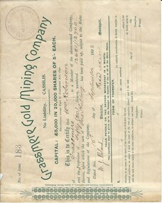
Document, Share Certificate
Grassmere is a small hamlet about 12 kilometres from Warrnambool. It is a farming area. The Grassmere Gold Mining Company, presumably established by local people in Grassmere, was created in 1898 for the purpose of acquiring from Messrs James and Mewha a lease of a Cassilis gold mine (23 acres). £5000 was to be raised in shares of five shillings and one shilling each. The Manager of the Company was Horatio Dickson of Melbourne and the brokers were McMeekin and Co. of Melbourne and Warrnambool and Dickson and Osborne of Melbourne. This reef mine was one of several in Cassilis, Gippsland, 12 kilometres north west of Swifts Creek. The gold-bearing quartz reefs were discovered in 1885 and worked to 1914. It is not known whether the Grassmere Cassilis mine was a financial success but the mining operations were impeded by the hardness of the stone in the area. William Robinson was a farmer in the Grassmere district. This certificate is of considerable interest as one of only three items the Warrnambool and District Historical Society has that is connected with the establishment of the Grassmere Gold Mining Company. The gold mine establishment was one of the many minor events in the district in the 1890s. This is a small buff-coloured certificate detailing the shares of William Robinson in the Grassmere Gold Mining Company (1898). The certificate has green printing and black-ink handwriting. The bottom section (Form of Transfer) is not filled in. There is a stamp of the Grassmere Gold Mining Company with the words ‘No Liability’. There is a decorative pattern in green on the left margin with the address of the company and the name of the printer. ‘This is to certify that Wm. Robinson of Grassmere is a member of the above-named company and the proprietor of fifty (50) shares, numbering 12651/12700 therein, upon which the sum of one shilling has been paid up, subject to the Rules and Regulations of the Company. Dated this 15th day of September, 1898. W.J. Roland, Director, .H. (es) Dickson, Manager.’grassmere, grassmere gold mining company, william robinson, warrnambool -
Bendigo Historical Society Inc.
Document - MINING IN BENDIGO COLLECTION: NAMES OF MINING SLIDES
BHS CollectionTyped copy and two handwritten copies of index to mining slides per Bob Aulsbrook, 30.12.69 and Ian Hendry.document, gold, mining in bendigo, mining in bendigo, names of mining slides, bob aulsbrook, ian hendry, new chum railway, healthy golden bendigo, lansells 222, lansell's fortuna, old chum mine, from new chum hill, to victoria hill, plan of leases on victoria hill 1859, lansell's big 180, bendigo & vicinity, victoria quartz, wm rae's crushing machine, hercules & energetic, mungo mines, united devonshire, mungo group & devonshire mines 1888, catherine reef united, garden gully united, knipe;s castle, old carlisle, nth garden & passby, koch's pioneer quartz crushing battery, great northern mine, virginia mine, specimen hill, new argus, south new moon, new moon, big blue mine, eadie's whim & central blue mine, fortuna hustlers, pictorial photos of victorian views, hustler's royal reserve mine - city, extended hustler's freehold - looking south, great extended hustlers, hustlers reef mine, central nell gwynne, cornish boiler, lancashire boiler, wannan's e'drivers guide, winding engine - new moon, 20 drill air compressor - new moon 1904, engine at virginia crushing battery, lansell's 105 head crushing battery, deeble's pyrites works, miner at central deborah, level at 1045 feet at new moon, boring on a reef at catherine reef, deborah mine 1000 ft level, mines dep't melb & bendigo, engine beds lansell's big 180, new hustlers, rae's open cut, ballerstedt's first open cut, 3 of early days of bendigo, geo lansell -
 Bendigo Historical Society Inc.
Document - MCCOLL, RANKIN AND STANISTREET COLLECTION: CENTRAL GARDEN GULLY GOLD MINING CO NL, 1933 -1936
Document. Envelope contains: - Tribute Agreements. Sales Agreement for Quartz Prospecting Claims, Lease Agreements, Cert. of Inspection of Boiler, Hire Agreement for Boiler.McColl, Rankin & Stanistreetorganization, business, gold mine, mccoll, rankin & stanistreet, central garden gully gmc, gold mining, lease agreements -
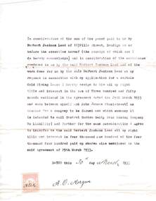
 Linton and District Historical Society Inc
Report, Shire of Grenville, Engineer's Report re Gravel Heaps, 7th July 1916
Single sheet approximately A4 in size, folded to form four pages. Three-page report prepared by M. Martin, Shire Engineer, detailing the advisability of and legal basis for the Shire of Grenville retaining control of various quartz and tailing heaps (remnants of mining) located throughout the Shire.Text: " SHIRE OF GRENVILLE. / ENGINEER'S REPORT RE GRAVEL HEAPS. / COUNCIL MEETING, 7th JULY, 1916. "shire of grenville, gravel heaps, mining, roads -
Clunes Museum
Newspaper - NEWSPAPER CUTTING, ARGUS AGE, 1 CLUNES BIRTHDAY .2 FAMOUS MINING TOWNS, 4 - 7 - 1931 27 - 8 - 32
NEWSPAPER HEADLINES. CLUNES BIRTHDAY. FAMOUS MINING TOWNS .1. 80TH ANNIVERSARY JULY 4, 1931 .2. THE QUARTZ REEFS OF CLUNES. SOME INTERESTING DOCUMENTS..2 NEWSPAPER CUTTINGS. .1. CLUNES MINING 80TH ANNIVERSARY JULY 4, 1931 .2. THE QUARTZ REEFS OF CLUNES. SOME INTERESTING DOCUMENTS.local history, document, newspaper cutting, mining -
 Eltham District Historical Society Inc
Photograph - Digital Photograph, Marguerite Marshall, One Tree Hill Mine, Smiths Gully, 8 June 2006
Gold was discovered on One Tree Hill in 1854. The site has been worked intermittently until fairly recent times. Published: Nillumbik Now and Then / Marguerite Marshall 2008; photographs Alan King with Marguerite Marshall.; p53 Though still a working mine, One Tree Hill Mine at Smiths Gully, now stands in a tranquil reserve surrounded by bush and native animals - in contrast to its heyday. In the mid 19th century, when the mine was part of the Caledonia Goldfields, hundreds of men in search of their fortune worked the alluvial gold in the Yarra River, its tributaries and the reefs that made up the goldfields. Miner Stan Bone, assisted by Wilfred Haywood, is the last of the independent gold miners in the area and still uses the quartz crushing battery as miners did when gold was first discovered in the area in 1851.1 Stan, who is the last of six generations of miners in his family, was aged 17 when he began mining on his father Alex’ mine, The Golden Crown in Yarrambat. These days, after blasting the gold-bearing rock in Mystery Reef, one of the four reefs at One Tree Hill, Stan transports it around five kilometres by tip truck to the Black Cameron Mine for crushing. There he uses water from the waterlogged mine, (which still contains gold), as the Happy Valley Creek at One Tree Hill is usually dry.2 The One Tree Hill Mine has been worked for close to a century since it opened around the late 1850s.3 The Swedish Reef was its most productive reef and one of the largest in the area. Around 1859, extractions included 204 ounces (5.8kg) of gold, won from 57 pounds (26kg) of stone.4 Then during World War Two, Stan’s uncle, Bill Wallace, and Alex Bone, closed the mine. In 1973, Stan, with his Uncle Bill, reopened the Black Cameron Mine and worked there until 1988. Stan resumed mining One Tree Hill in 1998. As late as the 1920s gold was picked up by chance! When crossing a gully on his way to vote at the St Andrews Primary School, Bill Joyce picked up some quartz containing gold. This site was to become the Black Cameron Mine. The Caledonia Diggings, named after Scotland’s ancient name by local Scots, began around Market Square (now Smiths Gully) and included Queenstown (St Andrews), Kingstown (Panton Hill) and Diamond Creek. There were also poorer bearing fields in Kangaroo Ground and Swipers Gully (now Research). * None of these compared in riches to the Ballarat and Bendigo fields5, but the Caledonia Diggings continued intermittently for close to 100 years. Gold was discovered in Victoria following a bid to stem the disappearance of much needed workmen to the New South Wales diggings. Several businessmen offered a reward of £200, for the discovery of gold within 200 miles (322 km) of Melbourne. Late in June 1851, gold was first discovered at Andersons Creek, Warrandyte. Then in 1854, George Boston and two other men discovered gold at Smiths Gully. Gold transformed the quiet districts, with a constant flow of families and vehicles on the dirt tracks en route to the Caledonia Diggings. Three thousand people worked the gullies in Market Square, including about 1000 Chinese miners. The square established its own police, mining warden, gold battery, school, shops and cemetery and grog flowed. Market Square flourished until the middle 1860s. Bullocks transported quartz from the Caledonia Goldfields to the crushing machinery at the Queenstown/St Andrews Battery, near Smiths Gully Cemetery. It was destroyed by bushfire in 1962. By the late 1850s, most early alluvial fields were in decline, but minor rushes continued until around 1900 and some until the early 1940s. Some miners did well, although most earned little from their hard labour in the harsh and primitive conditions.6 But according to historian, Mick Woiwod, the gold fields helped to democratise society, as individuals from all walks of life were forced to share experiences, and the ability to succeed, depended less on inherited wealth or social rank.This collection of almost 130 photos about places and people within the Shire of Nillumbik, an urban and rural municipality in Melbourne's north, contributes to an understanding of the history of the Shire. Published in 2008 immediately prior to the Black Saturday bushfires of February 7, 2009, it documents sites that were impacted, and in some cases destroyed by the fires. It includes photographs taken especially for the publication, creating a unique time capsule representing the Shire in the early 21st century. It remains the most recent comprehenesive publication devoted to the Shire's history connecting local residents to the past. nillumbik now and then (marshall-king) collection, gold mining, one tree hill mine, smiths gully -
 Eltham District Historical Society Inc
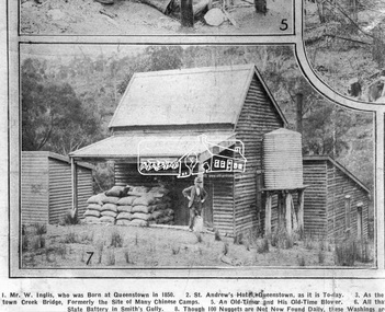
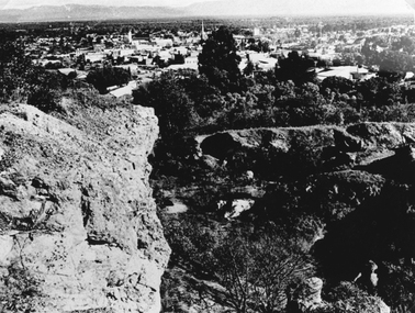
Photograph, Queenstown - St. Andrews District. "Quartz awaiting crushing at the State Battery in Smith's Gully.", c.1929
"The State Battery was the central component in the gold mining of this area from the 1920s. The battery crushed the gold bearing quartz extracted from the mines and was a sizeable weatherboard building enclosing the engine and stampers. All that now remains are the bases for the machinery that comprised the battery, one timber and a couple of concrete bases and the nearby dam, which supplied water. However the historic significance of the site remains and is enhanced by the Queenstown Cemetery on the other side of Smiths Gully Road". - Bick Study 1922 This site is now the Peter Franke Reserve and is managed by Parks Victoria Photo Source: The Leader, Nov. 2nd, 1929This photo forms part of a collection of photographs gathered by the Shire of Eltham for their centenary project book,"Pioneers and Painters: 100 years of the Shire of Eltham" by Alan Marshall (1971). The collection of over 500 images is held in partnership between Eltham District Historical Society and Yarra Plenty Regional Library (Eltham Library) and is now formally known as the 'The Shire of Eltham Pioneers Photograph Collection.' It is significant in being the first community sourced collection representing the places and people of the Shire's first one hundred years.Digital imagesepp, shire of eltham pioneers photograph collection, queenstown, st andrews, gold mining, smiths gully -
 Eltham District Historical Society Inc
Photograph - Digital Photograph, Alan King, St Andrews Anglican Church, St Andrews, 30 January 2008
Built c.1868, St Andrew’s Anglican Church is Nillumbik Shire’s oldest timber church and is historically, socially, and spiritually significant to the Shire of Nillumbik. The church is historically significant because it may have given its name 'St Andrews' to the town (another suggestion is that the name came from the local hotel), it is also historically significant as one of only four buildings that remain from the Caledonian goldfields era of Queenstown (now St Andrews) and one of only a handful of buildings that survived the 1960s bushfires. The church is historically, socially, and spiritually significant because it has played an important part in community life for more than 150 years; a proposal to move the church in 1984 met with strenuous opposition. Much of the fires on Black Saturday 2009 were the north of the town. The town itself remained intact - as did this heritage building. Covered under Heritage Overlay, Nillumbik Planning Scheme. National Trust of Australia (Victoria) Local significance Published: Nillumbik Now and Then / Marguerite Marshall 2008; photographs Alan King with Marguerite Marshall.; p69 The St Andrews Anglican Church and former St Andrews Primary School, are two reminders of the district’s early days, when it was founded on gold. St Andrews, then called Queenstown, was the earliest goldfield in the Caledonia Diggings.1 It was the Upper Diamond Gold Mining and Administrative Centre, with 3000 miners. Queenstown was also the seat of the Court of Petty Sessions. The church and school then stood close to European and Chinese stores, three hotels, a brewery and a quartz mill.2 In 1861, Queenstown was officially proclaimed a township. From 1865, the name Queenstown was interchangeable with St Andrews, until 1952, when the town was officially named St Andrews. As gold declined from the early 1880s, Queenstown changed dramatically into a settlement of small farms. St Andrew’s Anglican Church, built in 1868, is the Shire’s oldest timber church and possibly gave its name to the township.3 The small timber church was opened on November 1, 1869, by the Dean of Melbourne. Anniversary tea meetings helped raise funds, and in 1889, a three-bedroom parsonage was built alongside. In 1910, the vicar, the Rev Selwyn Chase (and friend of the Scouting Movement’s founder, Baden Powell), established the 1st Queenstown Scout Troop, only two years after Scouting began in Australia. The church was important to the lives of many local residents who were baptised, married and had funeral services there. But by the 1950s the population had decreased and so did the weekly attendances. Around the mid-1960s the church closed, then fell into disrepair. So in the mid 1980s it was sold to the Education Department and was under threat of relocation or demolition. However this caused such opposition from locals,4 that instead, the Anglican church leased it as part of the Panton Hill parish5 and it was reconsecrated in 1987. Queenstown’s first school was held in a tent after transferring from Andersons Creek, Warrandyte.6 From 1858 a church school, Caledonia Diggings, stood west of the main road, a quarter of a mile (0.4km) before Buttermans Track. In 1882 the school was moved from a leased building, owned by headmaster Robert Harris, into a larger building on the corner of the School and the Heidelberg-Kinglake Roads. It had been moved from Smiths Gully and included a teacher’s three-roomed residence.7 In 1887 the school was replaced by the Queenstown State School No 128, although it was also called Caledonia Diggings until 1891. In 1956 it was renamed St Andrews. Still standing, this building is now used as the St Andrews Community Centre and the residence is leased for private use. The original timber-lined room remains alongside the extensions, and is distinctive with its high ceiling and tall small-paned windows. In 1984 a new school was built 500 metres west of the old school. Many residents have contributed much to St Andrews but one family that has done so for several generations is the Harris family. Robert Harris was an active member of the St Andrew’s Anglican Church, and worked hard at improving the town’s amenities until his death in 1887. He was a signatory to the successful 1863 petition to the Chief Commissioner of Police, against the proposed removal of the Court of Petty Sessions and police station at the Caledonia Diggings. The police station stayed in the town until 1917. Harris was Head Teacher of Queenstown State School from 1864 to 1874, then of the Smiths Gully school until it closed in 1882, and he continued teaching at Panton Hill until his death. His son, Robert Charles Harris, was editor and printer of the local newspaper, The Evelyn Observer, from 1873 until 1915. Robert’s son, William Shelley Harris, served in the Boer War and in World War One. In 1928 he became Kinglake National Park’s first park ranger. Robert’s daughter Elizabeth, taught needlework at Queenstown State School, and later ran the post office in Kinglake.This collection of almost 130 photos about places and people within the Shire of Nillumbik, an urban and rural municipality in Melbourne's north, contributes to an understanding of the history of the Shire. Published in 2008 immediately prior to the Black Saturday bushfires of February 7, 2009, it documents sites that were impacted, and in some cases destroyed by the fires. It includes photographs taken especially for the publication, creating a unique time capsule representing the Shire in the early 21st century. It remains the most recent comprehenesive publication devoted to the Shire's history connecting local residents to the past. nillumbik now and then (marshall-king) collection, st andrews, st andrews anglican church -
 Bendigo Historical Society Inc.
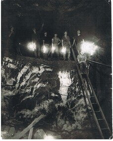
Photograph - HERCULES AND ENERGETIC MINE, 1939
black and white photo of underground mining, showing 8 miners in a stope with their Bendigo bucket carbide lights. A large quartz spur formation is visible in the foreground. A wooden ladder gives a good scale in relation to the stope size. Photograph taken in the Central Nell Gwynne at the 265 m. level C 1939. On back MNc4 ( in indian ink ) ? Hercules and Energetic ( in ball point pen ) RHSV of Vic. Stamp.organization, business, hercules and energetic mine -
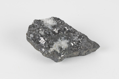 The Beechworth Burke Museum
Geological specimen - Galena (with quartz), unknown
Galena is the natural compound of lead and classed as a sulphide, it crystallises in a cubic pattern and its chemical formula is PbS. Galena is a primary source of both lead and silver. This specimen of Galena comes from Broken Hill. Broken Hill has one of the world’s largest and most significant deposit of ore for the production of lead. Mining of Galena at Broken Hill began with the staking of land by Charles Rasp in 1883. By the following year, in 1884, Rasp and six others had formed Broken Hill Mining Company. Broken Hill Mining Company eventually evolved into BHP group limited and is currently the largest mining company in the world and the largest company in Australia. There is archaeological evidence from artefacts discovered in Turkey that humans have been extracting lead from galena by the process of smelting since at least 6500 BCE. This specimen also has quartz on the top surface which is frequently discovered alongside Galena. This mineral specimen is of historic significance as a sample of Galena extracted from Broken Hill during the 19th century. Mining for Galena in Broken Hill begin in 1883 by Charles Rasp and evolved into the world’s largest mining company – BHP Group Limited. Broken Hill is one of the world’s most significant deposits of ore for the production of lead. This specimen is part of a larger collection of geological and mineral specimens collected from around Australia (and some parts of the world) and donated to the Burke Museum between 1868-1880. A large percentage of these specimens were collected in Victoria as part of the Geological Survey of Victoria that begun in 1852 (in response to the Gold Rush) to study and map the geology of Victoria. Collecting geological specimens was an important part of mapping and understanding the scientific makeup of the earth. Many of these specimens were sent to research and collecting organisations across Australia, including the Burke Museum, to educate and encourage further study.A flat, hand-sized, grey sulphide specimen that is the natural compound of lead with a quartz formation on the top surface. Existing Label: GALENA / (with quartz) / Locality: Broken Hill / N.S.W 120 x 70 x 29geological specimen, geology, geology collection, burke museum, beechworth, galena, galena quartz, quartz, charles rasp, broken hill mining company, bhp group limited, bhp, lead, ore, lead sulphide, sulphide, silver, broken hill -
 Stawell Historical Society Inc
Photograph, Open Cut Big Hill overlooking Stawell towards Grampians
Scotts Open Cut Big Hill c 1960 overlooking Stawell towards Grampians. The first quartz was mined for in the open cut from Fisher Street, to the Big Hill, below the Pioneers Memorial.Black and white photograph of an open cut on the side of a big hill. The township in the background.stawell mining -
 Bendigo Historical Society Inc.
Administrative record - South New Chum Syncline Gold Mines N.L. Minute Book, 1932 - 1940
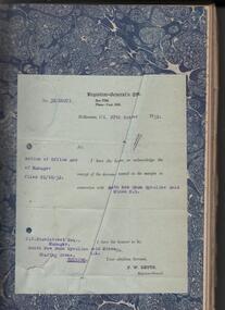
South New Chum Syncline South New Chum Syncline Gold Mines, N.L., has been floated with a capital of £27,500 in 55,000 shares of 10/ each. Forty thousand have been issued at 1/,10,000 fully paid shares go to vendors, and 5000 will be held in reserve. - Messrs. Savage and Nicholas report that the issue was heavily over-subscribed. The property is situated in the central portion of the Bendigo field, adjoining such former producers as the Victoria Quartz. Lansell’s Big 180, North Old Chum and New Chum. (Bendigo Advertiser, 29th September 1932).Green hard cover book, maroon binding on spine, 284 pages of which 94 are used. 'Minute Book' on front cover. Written in pencil across top of name ' South New Chum Syncline'. Inside front cover affixed to page, document 'Registrar-General re Notice of Office and of Manager, filed 23.10.32 in connection with South New Chum Syncline Gold Mines N.L. Minutes in book date from 5th October 1932 to 23rd August 1935. First minutes of meeting describes the Company as having 55,000 shares of ten shillings each. Final two pages have documents affixed that relate to the closure and sell-off of the free-hold property and mine equipment in 'Happy Valley Road, Bendigo for the sum of not less than Two Hundred and fifty pounds and that out of the proceeds thereof the following amounts be paid', An amount of 120 pounds, thirteen shillings and two pence are listed. Minute Book is part of the Margaret Roberts Collection. bendigo, gold mining, south new chum syncline gold mine, j.j. stanistreet, legal manager, margaret roberts collection, -
 Bendigo Historical Society Inc.
Document - MARKS COLLECTION: YOUNGMAN & HARRISON PATENT BASIN PULVERISING QUARTZ TAILINGS
Blue handwritten one page document detailing 'Youngman & Harrisons Patent Basin for pulverizing quartz tailings and amalgamating fine gold with mercury'. Introductory comments the basin contains greater advantages for pulverizing quartz tailings & amalgamating than any yet constructed for that purpose; In its construction all machinery complications have been carefully avoided and yet it embodies all the best methods known for treating tailings and has besides other than advantages (both in cash and labour) that of treating puddling machine sludge and can be used as a concentrator with little or no extra expense.bendigo, mining, youngman & harrisons patent basin -
 Bendigo Historical Society Inc.
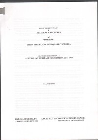
Document - Pompeii Fountain & Adjacent Structures at "Fortuna"
Fortuna Villa was initially commenced as a modest single storey home in 1861 next to the 180 Mine by Theodore Ballerstedt, who sold the mine and house to George Lansell in 1869. Lansell already owned the adjacent Fortuna Mine, and through deeper mining techniques greatly expanded the mine's operation, his personal wealth, and the house and grounds. Lansell was soon known as the 'Quartz King', Australia's first gold mining millionaire and credited as the driving force behind much of Bendigo's prosperity. He continuously added to and expanded the villa, decorating it extravagantly with the finest of artworks and materials, into a sprawling mansion with extensive landscaped grounds, to create a house and grounds of a size and grandeur with few rivals in Australia. After his death in 1907, his second wife Edith carried on with improvements, creating a house and grounds developed over 50 years. The attached mine also contributes to its significance, being one of the richest mines in Bendigo, and at one stage probably the deepest gold mine in the world at 3176 feet. The 1875 crushing works are attached directly to the mansion, and the mine's tailings and settling ponds (turned into ornamental lakes) represent a direct link between George Lansell's wealth and its source. Fortuna was compulsorily acquired by the Commonwealth in 1942 as the Cartographic Headquarters of the Australian Survey Corps during World War II, and many ancillary structures were added while preserving the main house and ornamental grounds. Victorian Heritage Database Report https://vhd.heritagecouncil.vic.gov.au/places/68334/download-reportConservation report for the Pompeii Fountain & Adjacent Structures at "Fortuna" Chum Street, Golden Square, Victoria. Prepared for Fortuna Historical Committee. March 1996.Halina Eckersley, Architect & Conservation Planner, Kewpompeii fountain, greenhouse, fortuna lake, gardens -
 Bendigo Historical Society Inc.
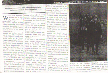
Newspaper - LONG GULLY HISTORY GROUP COLLECTION: WATER IN THE VICTORIA QUARTZ
BHS CollectionPhotocopy of a newspaper article titled Water Continues to Rise in the Victoria Quartz by James Lerk. Article mentions the water problem in the Victoria Quartz Mine and where they believed it was coming from. Also mentioned is the mining inspector William Abraham. There is a short history of his working life up to the time of his qualifying as a mine manager after studying part-time for ten years at the Bendigo School of Mines. There is a dark photo of William and his horse.bendigo, history, long gully history group, the long gully history group - water in the victoria quartz, james lerk, victoria quartz, william abraham, new chum reef, matthew stevens, south bellevue, new chum and victoria mine, lazarus, new chum drainage association, william abraham snr, druid, mary kane, lady miltoa, ballarat freehold company, the wallaby, richard grenfell, bendigo advertiser, bendigo school of mines, confidence extended mine, george ellis -
 Bendigo Historical Society Inc.
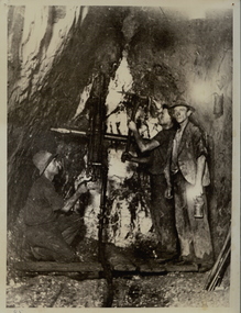
Photograph - DEBORAH MINE: UNDERGROUND
Black and white photograph. Three males underground in Deborah Mine with drill and pick. Lamp on wall. Quartz shows well. Deborah Mine 1000 ft. level. Inscription on back: A. Richardson, 29 Harrison St., Bendigo.mining, underground equipment, miners, bendigo, mines and mining, mine, mines, miners, person, males, workers, group, central deborah mine -
 Federation University Historical Collection
Map, Ballaarat Gold Field, 1861, 1861
A party of surveyors camped by Yuille's Swamp (later Lake Wendouree) and surveyed the countryside for a map to be produced by the Geological Survey of Victoria. In November 2004 the Central Highlands Regional Library presented a special edition of 200 copies of the 1861 map reproduced from a copy in their collection. Original 1861 map of Ballarat showing streets and leads. Blue dots indicate gold leads, and red lines indicate auriferous quartz reef and outcrops of quartz veins."Compiled & Drawn from the Survey of Mining Surveyors Davidson, Fitzpatrick and Cowan & the Plans in the Surveyor General's Office by J. Brahe, 21st October 1861. R. Brough Smyth, Secretary for Mines. The Honourable J.B. Humffray, M.L.A. Commr of Mines.”ballarat, map, ballarat east, lake wendouree, survey, mines, robert davidson, ballarat gold field 1861, yuille's swamp, wendouree swamp, little bendigo diggings, gold leads, old post office hill, specimen hill, bakery hill, black hill, dead horse creek, brown hill, pennyweight hill, clayton hill, soldiers hill, golden point, gum tree flat, white flat, poverty hill, chinese village, robert brough smyth, ballarat map 1861, ballaarat vineyard, dead horse gully, deadhorse creek, invermay, black hill flat, gaelic church, police reserve, magpie range, dalton's flat, caadian lead, rifle butts, powder magazine, bathing house, government camp, gold office, chinese, llanberrris, victoria theatre, charlie napier hotel, united states hotel, grape's hoel, clayton's hill, cattleyard hill, free trade hotel, esmond lead, bakery hill, black hill lead, juvenile reformatory, ballarat orphanage, lady barkly lead, triffet's slaughter yard, little bendigo, melbourne road, t. cowan, thomas cowan -
 Bendigo Historical Society Inc.
Document - DRAINAGE PROBLEMS - WATER PROBLEMS
Two handwritten pages with extracts from the Bendigo Advertiser Mining Intelligence. Notes mention making arrangements with other mines to resume bailing, Victoria Quartz still shaft sinking despite strong flow of water, Lansell's 180 preparing to bail water from the deep levels, so that the Victoria Quartz may continue shaft sinking and finishing cutting of plat at 4454 ft. Also a weather report on the 14/6/1910. From the Albert Richardson Mining History Collection.gold, drainage problems, drainage problems, water problems, bendigo advertiser mining intelligence 18/4/1910, 9/5/1910, 23/5/1910, 30/5/1910, 6/6/1910, 13/6/1910, victoria quartz, lazarus coy, lansell's 180, albert richardson -
 Bendigo Historical Society Inc.
Document - DRAINAGE PROBLEMS - DRAINAGE PROBLEMS 1910
Handwritten notes from Bendigo Advertiser reports. (1) Mr J. H. Craig reports- Victoria Reef Quartz - Cleaned and tested No 3 boiler. Have bailed 3,905 tanks. Water now 2.953 feet from surface. At Lazarus - Bailed 4,828 tanks. At New Chum Railway - Cleaned and tested boilers and flues, effected repairs to machinery and shaft, and started bailing at 3 pm on Friday 29th inst, and bailed 965 tanks. Bendig Advertiser 3/8/1910 Page 2 Mining Intelligence. (2) New Chum Mines - Better progress is now being made in lowering the water in the deep level workings at the New Chum Mines. At the Victoria Quartz, the water which on Monday stood at 3073feet, has been lowered 70 feet during the past four days. The pumping service at the New Chum Railway was in operation yesterday, and the winding plant is fully occupied. There is a considerable quantity of water toraise, and the companies have a difficult task before them. Bendigo Advertiser 5/8/1910 Page 2. Document from Albert Richardson Collection of mining history.gold, drainage problems, new chum drainage association, new chum mines drainage problems 1910, bendigo advertiser 3/8/1910 page 2, mr j h craig, victoria reef quartz, lazarus, new chum railway, bendigo advertiser 5/8/1910 page 2, albert richardson -
 Bendigo Historical Society Inc.
Document - DRAINAGE PROBLEMS - VICTORIA QUARTZ DRAINAGE PROBLEMS
Handwritten notes from the Bendigo Advertiser 5/7/1910 Page 3. 'New Chum Mines. Yesterday, Mr H. V. Whetelaw, officer in charge of the local survey branch, Mines Dep't accompanied by Inspector Ross, made their first inspection. Water has reached the 3224 ft. level. Now 1530 feet of water in shaft, including the workings below the 3324 ft. level. Bailing been carried on at the Victoria Quartz, Lansell's 180, 222, and New Chum Consolidated. It will take a week or more to get the Lazarus plant in readiness. Then the shaft will have to examined. At Lansell's 222, the water is 18 ft. below the No 18 level, New Chum Consolidated - 18 ft. below, the 1910 ft. Plat.' Bendigo Advertiser- New Chum Mines - 5/7/1910 Page 3. Document from Albert Richardson Collection of mining history.gold, drainage problems, new chum drainage association, victoria quartz drainage problems, bendigo advertiser 5/7/1910 page 3, mr h v whitelaw, mines dept, inspector ross, victoria quartz, lansell's 180, 222, new chum consolidated, lazarus, albert richardson -
 Bendigo Historical Society Inc.
Document - DRAINAGE PROBLEMS - VICTORIA QUARTZ
Handwritten copy of reports from the Bendigo Advertiser regarding water in the mine. (1) The bailing of water is occupying attention in other mines (from Shamrock North) to the Victoria Quartz. The water despite the efforts of the companies engaged bailing, continues to rise. Bendigo Advertiser July 18th Page 3. (2) Victoria Quartz Half Yearly Meeting, Lapsed, No quorum. Directors' Report: Sinking of shaft carried on till 14th June, when it was 4,614 ft. deep. Progress very satisfactory. Progress very satisfactory considering increase of water. As water was interfering with work, made arrangements on 3rd May, that 180 Mine should bail, and Minister of Mines agreed to allow, expense to be charged against work subsidised by Government. Arrangements now made for Lazarus, 222 and New Chum Consolidated mines to bail to unwater line of reef. Victoria Consols, Ironbark, 83, and Hercules and Energetic Companies have undertaken to contribute to cost, and Gov't will allow this to be charged on grant. Document from Albert Richardson Collection of mining history.gold, drainage problems, new chum drainage association, victoria quartz, bendigo advertiserjuly 18th page 2 mining intelligence, bendigo advertiser 20/7/1910 page 3, lazarus, 222, new chum consolidated, victoria consols, ironbark, 83, hercules and energetic, albert richardson -
 Bendigo Historical Society Inc.
Document - DRAINAGE PROBLEMS - DRAINAGE PROBLEMS NEW CHUM LINE
Handwritten copy of a report from the Bendigo Advertiser 25/7/1910. 'A Weeks Record. On Monday, July 18th, water level at Victoria Quartz was 3034 feet. On Saturday (July 23rd) the water had only been lowered to 3059 feet. A gain of 25 feet for a week. Document from Albert Richardson Collection of mining history.gold, drainage problems, new chum drainage association, drainage problems new chum line, victoria quartz, bendigo advertiser 25/7/1910 & 23/7/1910, albert richardson -
 Bendigo Historical Society Inc.
Document - DRAINAGE PROBLEMS - BURST WATER MAIN UNDER GARDEN GULLY SANDHEAP
Handwritten notes from a Bendigo Advertiser report 7 Jan 1907. Three shifts of men working all Saturday and Sunday had not located the main. A large are of Eaglehawk and the City are without water. Had to timber a hole to a depth of 25 ft. Victoria Quartz, Windmill Hill, Needle, Confidence Ext'd, Princess Dagmar, Golden Age, Golden Pyke, Macduff, constellation, Gt Northern, (partly), Specimen Hill, Clarence, New Argus, Comet, Gt Central Victoria and Victoria Consols had to close because they had no water and five to six hundred men believed to be out of work. City Council will put water-carts on and supply residents free of charge. New Moon, South Moon, Virginia , Catherine and Devonshire mines get their water direct from the water race so they did not close down. Document from Albert Richardson Collection of mining history.gold, drainage problems, drainage problems, burst water main under garden gully sandheap, bendigo advertiser, 7/1/1907, victoria quartz, windmill hill, needle, confidence ext'd, princess dagmar, golden age, golden pyke, macduff, constellation, gt northern, (partly), specimen hill, clarence, new argus, comet, gt central victoria, victoria consols, north johnsons, johnson's reef, snobs hill line, new moon south moon, virginia, catherine, devonshire, albert richardson -
 Bendigo Historical Society Inc.
Document - DRAINAGE PROBLEMS - INRUSH OF WATER AT THE VICTORIA QUARTZ
Two handwritten copies of a Bendigo Advertiser report 16/6/1910 Page 7. This is a longer version of 3600.14. It was thought that the rush of water was from a dam bursting in one of the other mines, but as the water showed no signs of slowing that theory was discarded. The temperature of the incoming water was much higher than the Victoria Quartz was accustomed to bail, and this circumstance is significent in view of the increased temperature of the water at the deep levels in the New Chum Railway. Some months ago, the water commenced to flow from the New Chum Railway workings into the New Shenandoah, which is the next mine north. The water rose so rapidly that a disaster was narrowly averted. The mines along the line were connected at different levels and with the cessation of bailing at the deep levels in the southern mines, it was only to be expected that the water would find its way north to the Victoria Quartz. The water raised from the operating mines under the direction of the New Chum Drainage Association, a yeart or two ago used to exceed six million gallons per month. At that time there were eight companies bailing water, and even then some of the plants, especially those at the deep mines, were severely taxed in coping with the water, and performing ordinary work. Since some mines had discontinued bailing, the water has been filling up extensive workings, and as was predicted in the ''Advertiser'' some time ago, the Victoria Quartz Company could not expect to succeed with its deep sinking project without making some special provision for raising the water, which ultimately would become a source of trouble. The Victoria Quartz Company was allotted a special grant of 10,000 pound to assist in sinking the shaft 1000 ft from the 4254 ft level. Under the conditions of the grant, the Company had to contribute half the cost of the sinking, and the raising of the water has also been an exensive item. For the present, all attention will be concentrated in lowering the water, and should the appliances prove unequal to the task the deep sinking scheme can only be accomplished by resorting to some comprehensive system of combating the water'. Document from Albert Richardson Collection of mining history.document, gold, drainage problems, drainage problems, inrush of water at the victoria quartz, bendigo advertiser 16/6/1910 page 7, mine reports 13/6/1910, victoria quartz, lansell's 180, mr stevens, mr w abraham, new chum & victoria mine, new chum railway, new shenandoah, new chum drainage association -
 Bendigo Historical Society Inc.
Document - DRAINAGE PROBLEMS - NEW CHUM DRAINAGE PROPOSALS
Six pages of handwritten notes regarding the New Chum Drainage Proposals. Extracts from the Bendigo Advertiser mentioning the rising of the water in the New Chum Mines. An Advertiser report 27/12/1910 mentions that deep mining will have to be abandoned owing to the absence of some proper scheme to cope with the water. An arrangement had been made by which the companies affected along the line should contribute to a scheme. Suggestions made that the water be lifted by electric pumps. Baling with tanks had been tried for 6 months and then abandoned. Directors Report Victoria Reef Quartz Jan 1911 mentions unwatering had been carried on with assistance of Government. On the 20th Dec, one rope gave out. Decided that replacing it and doing the necessary work could not be met in the present financial conditions. It was also considered that the costof trying to reach the bottom reefcut in the New Chum Railway could not be continued by baling as its cost proved too expensive, while it could probably be done economically & effectively by electric pump which is now subject to negotiations with the Mining Dept.' At the end of the report is a Balance Sheet. Document from Albert Richardson Collection of mining history.document, gold, drainage problems, drainage problems, new chum drainage proposals, bendigo advertiser 11/1/1911 page 7, victoria quartz, victoria consols, bendigo advertiser 5/7/1910 page 3, mr h v whitelaw, mines dept, insp ross, lansell's 180, 222, new chum consolidated, lazarus, bendigo advertiser 6/7/1910 page 7, 9/7/1910 page 9, drainage troubles, bendigo advertiser 8/7/ page 8, new chum railway, south belle vue, eureka ext'd, bgo adv 25/7 1910, 27/12/1910 page 2, rae's machine, bendigo advertiser 2/1/1911, mr mcbride, mines dept, mr stanfield, mines act, bendigo advertiser 16/1/1911 page 3, victoria reef quartz half yearly meeting 1911, directors report and balance sheet, geo paynting -
 Bendigo Historical Society Inc.
Document - DRAINAGE PROBLEMS - MINERS SENSATIONAL EXPERIENCE AT THE VICTORIA QUARTZ
Handwritten notes from a Bendigo Advertiser report, Thursday June 16th 1910. Management had for some time been apprehensive that the flooding in the deep mines to the south would affect them. Lansell's 180 took the precaution of baling. On the Tuesday night the men at the Victoria Quartz had a sensational experience. The storage dam at 3324 ft level receives the overflow from the flooded mines to the south. The level connects with the 3310 level at the Big 180. The water flows uninterrupted into thestorage dam which has a capacity of about 270 tanks. The dam had been emptied on Tuesday morning and work continued until 10 pm that night. The platman noticed that the water was coming down the shaft in a regular torrent. They didn't take much notice as they thought it was a leakinig outlet valve on the ascending tank. At 11 pm the releiving shift came down the shaft and said that the dam at 3,324 ft must be overflowing. The velocity of the water pouring down the shaft increased and the men made a hurried exit from the bottom of the shaft which is down 310 ft from the 4.254 ft plat (a total depth of 4,564 ft). An inspection of the dam at the 3324 ft level found it to be overflowing. By morning (Wednesday) the shaft had filled, and the water rose to 7 ft in the plat at 4254 feet. Mining inspector hgave orders that men were not to go below the 3324 ft level. Baling continued without cessation at the Big 180 all day and could not lower the water. Drilling machines etc and a powerful air winch at the 4254 ft plat are under water. An inspection made of the 3100 ft level at the 180 mine where the workings are connected with the New Chum & Victoria showed that water was running strongly from that mine proving that the inrush was due to flooded water from the southern deep mines to the south. Document from Albert Richardson Collection of mining history. Document from Albert Richardson Collection of mining history.document, gold, drainage problems, new chum drainage scheme, miners sensational experience at the victoria quartz, bendigo advertiser 16/6/1910 page7, lansell's 180, big 180, new chum & victoria