Showing 453 items matching " railway lines "
-
 Bendigo Historical Society Inc.
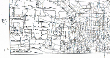
Map - LONG GULLY HISTORY GROUP COLLECTION: MAP OF REEFS AND MINES
BHS CollectionTwo pages with lines of reef and mines from Spring Gully Reservoir to north of the Eaglehawk Railway Station. Shown on the map are the lines of reef, the Thistle, Carshalton, Napoleon, British & Foreign, Nell Gwynne, New Chum, Sheepshead, Deborah, Garden Gully, Paddy's Gully, Derby, Miller's, Hustlers, Lightning Hill, Myers Flat, Lancashire, Cook's, Maiden Gully, Johnson's and Millers. Also shown are the Golden Square, Bendigo and Eaglehawk Railway Stations as well as the hills.bendigo, history, long gully history group, the long gully history group - map of reefs and mines, spring gully reservoir, thistle, carshalton, napoleon, british & foreign, nell gwynne, new chum, sheepshead, deborah, garden gully, paddy's gully, derby, miller's, hustlers, lightning hill, myers flat, lancashire, cook's, maiden gully, johnson's, millers, golden square railway station, bendigo railway station, eaglehawk railway station -
 Sunbury Family History and Heritage Society Inc.
Photograph, Jubilee train 1951, c 1951
The 'N' Class steam locomotives were built by Victorian Railways to be used on branch lines throughout the state's regional areas. A total of 73 of these locomotives were built between 1925 and 1951. The locomotive in the photograph carried the Jubilee Train that travelled throughout Victoria in 1951 and had a display featuring 125 years of European settlement in Victoria. When the photograph was taken the train was steaming into Sunbury where it stopped to allow people to board it and look at the exhibitionSunbury Station was an important stop for steam locomotives travelling on the Bendigo line. Even after diesel engines were used to pull the trains in the 1950s, steam locomotives were also used until the early 1990s.A non-digital black and white photograph of a 'N'class steam engine on railway tracks.steam locomotives, jubilee train, sunbury -
 Melbourne Tram Museum
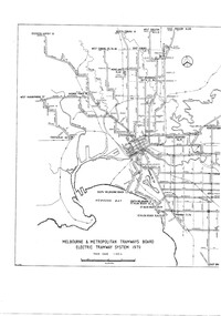
Drawing, Melbourne & Metropolitan Tramways Board (MMTB), "Melbourne & Metropolitan Tramways Board Electric Tramway System 1979", 1979
Photocopy of the track plan for the Melbourne Tramway System in 1979 over two separate sheets - titled "Melbourne & Metropolitan Tramways original pr Board Electric Tramway System 1979". Shows the route numbers and terminus names, depot locations, rail lines, cross overs and junctions. Has the name J.Chau in bottom left hand corner. See item 7740 for an original print.trams, tramways, melbourne, map, trackwork, depots, route numbers, railways, junction -
 Ballarat Tramway Museum
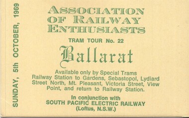
Ephemera - Ticket - Ballarat tram tour for 5-10-1969
Ticket produced by the Association of Railway Enthusiasts Melbourne for a Ballarat Tram tour in association with the South Pacific Electric Railway (Sydney Tram Museum) for Sunday 5 Oct. 1969 The tour covered all the Ballarat tram lines. Was run in conjunction with the Vintage Train to Ballarat that day. See reference. Used trams 35 and 41.Yields information about the type of souvenir ticket issued to participants.Ticket - printed on heavy yellow card with green inkballarat tramways, tours, association of railway enthusiasts, are, vintage train, sper, sydney tram museum -
 Bacchus Marsh & District Historical Society
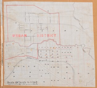
Map, Bacchus Marsh Urban District
The date of this map has not been established but the date would be sometime after 1887 as the Bacchus Marsh Railway Station, which opened in 1887, is shown on the map. A single page paper map showing blocks of land in the urban district of Bacchus Marsh. The 'urban district' is indicated by red drawn lines on the map and includes streets and blocks on the northern side of the Werribee River in Bacchus Marsh, and streets and blocks south of the Werribee in Maddingley. Scale 10 chains to 1 inch. The map is pasted into a bound volume containing 76 maps or plans in total. High resolution digital image stored on BMDHS computer network. bacchus marsh victoria maps, maddingley victoria maps -
 Victorian Railway History Library
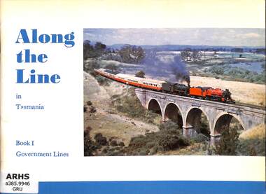
Book, Australian Railway Historical Society NSW Division, Along the Line in Tasmania book 1 Government Lines, 1982
... Lines Book Australian Railway Historical Society NSW Division ...Pictorial history of the Tasmanian Government Railways.ill, p.56.non-fictionPictorial history of the Tasmanian Government Railways.railroads - tasmania - pictorial works, steam locomotives - tasmania - history -
 Victorian Railway History Library
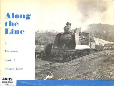
Book, Australian Railway Historical Society NSW Division, Along the Line in Tasmania: book 2 Private Lines, 1972
... Lines Book Australian Railway Historical Society NSW Division ...Pictorial history of Tasmanian's Private Railways.ill, p.52.non-fictionPictorial history of Tasmanian's Private Railways.railroads - tasmania - pictorial works, steam locomotives - tasmania - history -
 Bendigo Historical Society Inc.
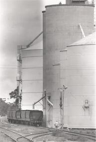
Photograph - PHOTOGRAPH. ELMORE SILOS, 1993
Photograph. Elmore silos next to railway line. Six railway trucks positioned ready to be filled. Man walking between lines toward silos and trucks.elmore, silos, agricultural -
 Melbourne Tram Museum
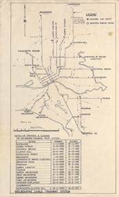
Map, Melbourne cable tram system, 1971?
Map showing the Melbourne cable tram system, with a list of opening and closing dates for the various lines, opened by the Melbourne Tramways Trust. Shows engine houses and car houses (or depots), location names, railways, and a scale. Includes notes on other dates tracks were changed and the Northcote to Clifton Hill line. No marks as to who prepared the map.Yields information about the Melbourne Cable Tram system.Foolscap sheet - Map - Melbourne cable tram system showing tracks, car houses and engine houses.Has a date stamp 22 Apr 1971 in bottom right hand corner.tramways, cable trams, trams, map, melbourne tramways trust, mtt, engine houses, depots, car houses -
 Melbourne Tram Museum
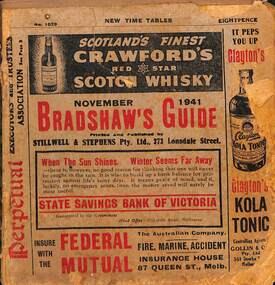
Book - Bradshaws Guide - November 1941, Stillwell & Stephens Pty Ltd
Provides detailed information on Victorian railways country timetables, suburban trains, lists of post offices, Victorian and Commonwealth Government officials and elected representatives, and tramways - all night services, first and last cars, including Sandringham and St Kilda services. Provides a detailed guide to services in Victoria, including public transport.Book - 194 pages, 9 sections stapled paper titled "Bradshaws Guide - November 1941" Priced 8d, No. 1029. Has a fold out map of the VR Country and suburban lines. Includes many advertisements.victoria, tramways, melbourne, timetables, railways, guides, bradshaws guide, advertisements -
 Melbourne Tram Museum
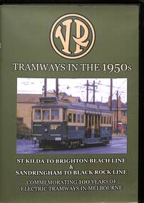
Film - DVD - Audio-Visual, Efftech, "VR Tramways in the 1950s", 2006
The DVD tells the story of the Victorian railways tramways in the 1950s for both the St Kilda to Brighton Beach line and the Sandringham to Black Rock lines. Produced and narrated by Roger Greenwood of Efftech Pty Ltd.Yields information about the two tramways operated by the Victorian Railways during the 1950sDVD compact diskette in a black plastic box with covers, titled "VR Tramways in the 1950s" with photos of Victorian Railways trams on the front and rear cover. Produced by Efftech in 2006.films, tramways, trams, st kilda brighton electric tramway, sandringham, black rock tramway, efftech, roger greenwood -
 Melbourne Tram Museum
Document, Ministry of Transport, Melbourne Public Transport Map - No. 12, 1982
Map No. 12 - Includes description of tram and bus routes, private bus routes. On the front cover is composite image of Melbourne public transport vehicles. Has contact details for bookings and lost property etc and how to use the map. Priced at 40c, issue No. 12 of c1982. Has details of the then new Travelcard ticket system. Yields information about Melbourne public transport services in 1982.Fold out map (36 sections 9 across x 4 deep), "Public Transport Map", coloured of Melbourne's Tram and Bus routes, route numbers, rail lines, detailed for the central part of Melbourne and the outer Metropolitan services.tramways, melbourne, tram services, bus services, railways, travelcard -
 Melbourne Tram Museum
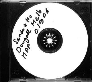
Map - CD - Sands McDougal Map Melbourne c1906, Sands McDougall
Detailed scan of the Sands McDougal Map in colour showing Melbourne's cable trams, railways, Essendon Tramways, NMETL and the Victorian Railways line to Brighton from St Kilda. Includes the MTOCo horse tram lines and the Caulfield horse tram lines. See Reg item 6572 for the actual map. Yields information about Melbourne and its tramways in 1906CD in a plastic case - black with clear cover.CD marked "Sands & McDougal Map c1906"cable trams, tramways, map, sands mcdougal, nmetl, vr trams, horse trams -
 Melbourne Tram Museum
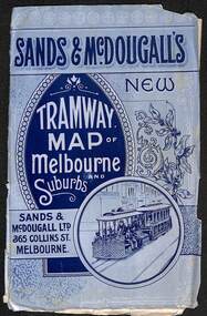
Map, Sands McDougall, "Tramway Map of Melbourne and Suburbs", c1906
Shows railways, cable and electric tram lines c1906. One of a number of maps produced by Sands McDougall of Collins St. Includes the MTOCo horse tram lines and the Caulfield horse tram lines. See items 2885 and 6573 for other editions. Yields information about Melbourne c1906 and its public transport lines. Map - folded sheet of paper 5 sections wide x 4 sections or folds deep contained within a light grey paper cover titled "Tramway Map of Melbourne and Suburbs"maps, melbourne, cable trams, tramways, railways, horse trams, nmetl, vr trams, sands mcdougall -
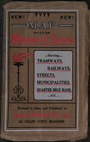 Melbourne Tram Museum
Map, Sands McDougall, Map of Melbourne and Suburbs showing Tramways, Railways, Streets, postal districts, Quarter-Mile Radii etc", c1919
Shows railways, cable and electric tram lines c1919. One of a number of maps produced by Sands McDougall of Collins St. Includes the MTOCo zoo horse tram lines, the PMTT, HTT and MBCTT lines, but not the FNPTT or the FTT lines. See items 2885 and 6573 for other editions. Yields information about Melbourne c1919 and its public transport lines. Produced by Sands and McDougall Pty Ltd of Collins St Melbourne. folded sheet of paper 6 sections wide x 6 sections or folds deep contained within a brown paper cover titled "Map of Melbourne and Suburbs showing Tramways, Railways, Streets, postal districts, Quarter-Mile Radii etc", showing both cable and electric tramways. maps, melbourne, cable trams, tramways, railways, horse trams, nmetl, vr trams, sands mcdougall, mbctt, pmtt, htt, zoo horse tramway -
 Melbourne Tram Museum
Map, Ministry of Transport, Melbourne Public Transport Map - No. 9, 1979
Map No. 9 - Includes description of tram and bus routes, private bus routes. Has contact details for bookings and lost property etc and how to use the map. Yields information about Melbourne public transport services in 1979Fold out map (27 sections 9 across x 3 deep), "Public Transport Map", coloured of Melbourne's Tram and Bus routes, route numbers, rail lines, detailed for the central part of Melbourne and the outer Metropolitan services.tramways, melbourne, tram services, bus services, railways, travelcard, maps -
 Melbourne Tram Museum
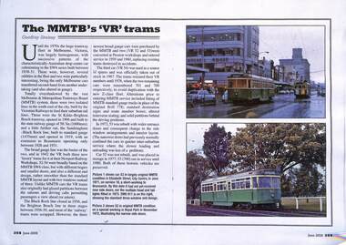
Magazine - Colour photocopy, Geoffrey Skelsey, "The MMTB's 'VR' trams", June 2009
Colour photocopy of an article by Geoffrey Skelsey providing a short history of the two VR tram lines, and the construction of the luxury trams, Nos. 52 to 54. Covers the use of the first two on the MMTB system and their operational history.Provides details of VR luxury trams in a UK based magazine,Photocopy of an article from the June 2009 issue of Tramway Review - two A4 sheets.trams, railways, vr trams, tram 52, tram 53, tram 54, mmtb, tramways, lrta -
 Melbourne Tram Museum
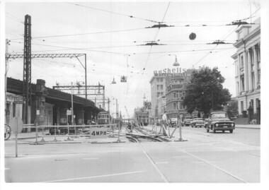
Photograph - Set of 12 - construction of King St overpass in Flinders St, 1959
Photos show the construction of King St overpass in Flinders St which was part of the project to construct a bridge over the Yarra River and provide a new southern outlet road between the city and eventually St Kilda Junction. The overpass construction was commenced in 1959 with tramway works first commencing. It was demolished in 2005. 1 - looking west at Market St. 2 - looking east from Spencer and Flinders St with the railway viaduct behind. 3 - Tram lines diverted onto the new overpass. Note the hand-powered overhead tower on the left behind the compressor. 4 - Tracks partially diverted. 5 - Looking east at Spencer and Flinders St with a Dunlop tyre truck in the view. 6 - prior to the diversion onto the new bridge. 7 - Looking east near William St. with W2 451 (Route 48, North Balwyn) in the view. 8 - Bridge works near King St. Original tracks still in use. 9 - Looking east prior to the introduction of the temporary tracks on the south side of the new overpass. 10 - SW6 852 and a W2 on new overpass trackwork - old trackwork being demolished. 11 - Cross over at Spencer St in Flinders St, prior to change over. 12 - Looking west at Flinders and Spencer St with SW6 853 turning into Spencer St.Yields information about the construction of the King St overpass in Flinders St during 1959.Set of 12 black and white prints of the construction of the King St overpass in Flinders St.trams, tramways, flinders st, king st overpass, construction, bridges, w2 class, sw6 class, tram 451, tram 853, tram 852 -
 Melbourne Tram Museum
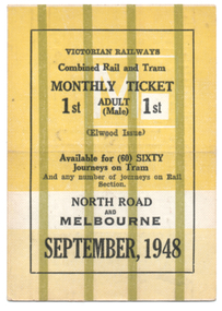
Ephemera - Rail & Tram Monthly ticket, Victorian Railways (VR), Sept. 1948
Victorian Railways Rail & Tram Monthly Periodical with conditions of travel on the inside. See reference page 124/125 and Figure 6-33. All tickets were available for 60 only tram trips, but allowed unlimited rail trips with 60 separate squares for a tram conductor to punch. This ticket is for First class travel, from North Road to Melbourne, though the rail portion only provided for first-class travel. Ticket No. 002 for September 1948. Colour of the ticket and markings varied for each month. Ticket has been cancelled with two red lines on one side.Demonstrates a Victorian Railways Rail and Tram monthly ticket for a specific section or trip on the St Kilda Brighton tramway. May have been used as a training sample.Printed card ticket, heavy card, coloured, with a crease in the middle so it could be folded.tickets, vr, vr trams, victorian railways, st kilda brighton tramway, monthy -
 City of Kingston
Pamphlet - Colour, Arthur Tuckett & Son, Auctioneers and Subdivisional Specialists, Auction of Station Estate, Moorabbin, 1923
Sales plan for land in the suburb of Moorabbin, bounded by Railway Crescent, South Road, Jasper Road and Pattersons Road.The developing urban area of Moorabbin within the City of Kingston. This land sale pamphlet illustrates the subdivision of land within the municipality and the changing demographic of the district as new houses are constructed.Colour pamphlet advertising an auction of the Station Estate Moorabbin. Incorporates details of the shopping facilities, proximity to the railway line, variety of schools and churches in the area, and a sales plan for home sites and shop fronts. Incorporates a map of the estate bordered by Pattersons Road, Japer Road, South Road and Railway Crescent. Handwritten in grey pencil top right front page: Station Estate / late [indecipherable] Handwritten in red pencil on subdivision map: x [on majority of properties marked on the map] Handwritten in grey pencil on subdivision map: additional subdivisions drawn in and large lines drawn across the mapmoorabbin, land sales, estate -
 Victorian Railway History Library
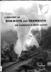
Book, Rae, Lou, A History of Railway and Tramways on Tasmania's West Coast, 1984
A history of the railways and tramways of the West Coast of Tasmania both private and government, 3'6" and narrower gauge lines.index, ill, maps, p.212.non-fictionA history of the railways and tramways of the West Coast of Tasmania both private and government, 3'6" and narrower gauge lines.railway operations - tasmania - history, railway construction - tasmania - history -
 Mont De Lancey
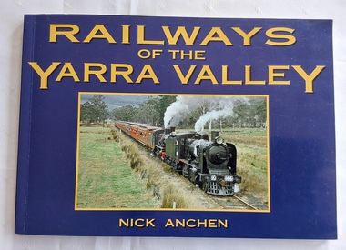
Book, Nick Anchen, Railways of the Yarra Valley, 2010
The railway reached Lilydale in 1882, Healesville in 1889 and Warburton in 1901 linking the area to Melbourne. Sawmillers and farmers prospered, as well as tourists visiting the region.A blue covered book of the Railways of the Yarra Valley with a photograph on the front cover of the last steam train from Warburton in August 1965 and the back cover showing an old locomotive 'Little Yarra' in 1913. There is historical text and maps with black and white and coloured photographs of the railways and of the area.Pp.96.non-fictionThe railway reached Lilydale in 1882, Healesville in 1889 and Warburton in 1901 linking the area to Melbourne. Sawmillers and farmers prospered, as well as tourists visiting the region. trains, rail vehicles, australian history, yarra valley -
 Victorian Railway History Library
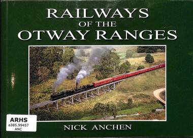
Book, Anchen, Nick, Railways of the Otway Ranges, 2011
... Railways lines to Wensleydale, Forrest and Timboon as well ...A pictorial history of railways in the Victorian Otway Ranges including the Victorian Railways lines to Wensleydale, Forrest and Timboon as well as the 2'6" narrow gauge railway to Crowes.ill, maps, p.96.non-fictionA pictorial history of railways in the Victorian Otway Ranges including the Victorian Railways lines to Wensleydale, Forrest and Timboon as well as the 2'6" narrow gauge railway to Crowes.railroad construction - victoria - history, logging railroads - victoria - otway range - history -
 Victorian Railway History Library
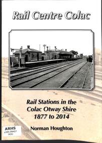
Book, Houghton, Norm, Rail Centre Colac, 2014
... stations on the Victorian Railways lines in the Colac Otway Shire ...An history of the rail stations on the Victorian Railways lines in the Colac Otway Shire including the lines to Forrest, Alvie, Cressy and the 2'6" narrow gauge railway to Crowes.index, ill, maps, p.262.non-fictionAn history of the rail stations on the Victorian Railways lines in the Colac Otway Shire including the lines to Forrest, Alvie, Cressy and the 2'6" narrow gauge railway to Crowes.railroad construction - victoria - history, logging railroads - victoria - otway range - history -
 Victorian Railway History Library
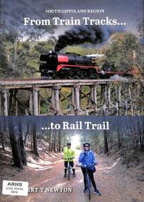
Book, Newton, Robert T, From Train Tracks... ...to Rail Trail, 2022
... - history A history of turning disused railway lines into rail ...A history of turning disused railway lines into rail trails for walkers and bicycles.index, ill, maps, p.270.non-fictionA history of turning disused railway lines into rail trails for walkers and bicycles.railroads - victoria - history, rail trails - victoria - history -
 Melbourne Tram Museum
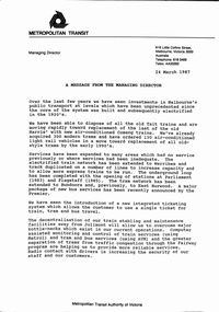
Document - Notice, The Met, "MTA Business Planning Report No. 1 - Analysis of the Existing situation", 24/03/1987 12:00:00 AM
Set of two A4 documents about the future and current situation or status of the Metropolitan Transit Authority of Victoria (The Met). .1 - A3 folded sheet, titled "A message from the Managing Director" signed by Kevin Shea, dated 24/3/1987 setting out the current situation, changes, services, Jolimont, new tram lines, ticketing, vehicles and future planning. Business Plan released the same day by the Minister Tom Roper. .2 - 12 A4 pages - centre stapled printed on orange paper, titled "MTA Business Planning Report No. 1 - Analysis of the Existing situation" - setting out the policy context, goals and objectives, international perspective, patronage and service levels, fares system, human resources, capital investment, financial performance, changing environment, key issues and next stepstrams, tramways, the met, planning, reports, finances, railways, new trams, new track -
 Melbourne Tram Museum
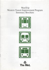
Document - Report, The Met, "WestTrip Western Transit Improvement Program Summary Brochure", 1989
Report or pamphlet or brochure - 16 pages, A4 gloss paper centre stapled titled "WestTrip Western Transit Improvement Program Summary Brochure", giving feedback to stakeholders on the consideration and outcomes of the Sept 1988 Met Plan for the Western suburbs for the following 15 years - train, tram and bus. Includes notes on the Process, study area, future development, existing transport, Metplan, Rail lines, Airport West Tram and West Maribyrnong Tram Line, Metlink buses and seeking comments. Includes maps for the two tram line extensions.trams, tramways, metplan, railways, west maribyrnong, airport west, new tramway, metplan -
 Melbourne Tram Museum
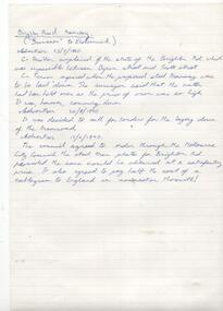
Document - Research Notes, Graeme Breydon, Proposed lines - St Kilda and Brighton, 1970 - 1971
Set of Research Notes, handwritten 17 foolscap sheets from the various local newspapers of the St Kilda area newspapers and Port Melbourne area about railway development, a proposal for a horse tramway along the Esplanade and other suburban railways that were proposed in the area. Also letters to and from the City of St Kilda and City of Brighton with reference to a article in the TMSV Running Journal and a copy of a letter on the same topic from Leon Marshall Wood. All dated 1970 - 1971. Includes references to other journals and research notes.trams, tramways, city of st kilda, meeting minutes, victorian railways, vr, horse trams, newspaper clippings, st kilda brighton, construction, the esplanade, city of brighton -
 Melbourne Tram Museum
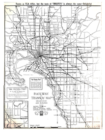
Map, Gawler and Drummond Architects, "Railway and Tramway Map of Melbourne and Suburbs", 1920's?
Map - photocopy - titled "Railway and Tramway Map of Melbourne and Suburbs", c1920 showing railways, cable, electric tramways and authorised electric additions. Shows the South Melbourne St Kilda tram line and some lines in the Footscray area as dotted. Prepared by Gawler and Drummond Architects. Has an advertisement for "Rolfes" tea along the top edge and "See Victoria First" - Government Tourist Office, corner of Swanston and Collins St.trams, tramways, map, footscray, st kilda, new tramway, melbourne, tourism -
 Melbourne Tram Museum
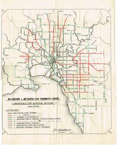
Map, Melbourne & Metropolitan Tramways Board (MMTB), "Proposals for General Scheme", 27/08/1923 12:00:00 AM
Map - drawing with a line back, titled "Melbourne and Metropolitan Tramways Board Proposals for General Scheme". Shows the proposed tram lines submitted to Parliament for the report into the General Scheme. Printed by Sands & McDougall Pty Ltd. Signed by J. P Strickland dated 27-8-1923. See Reg item 3374.2 for a better copy.trams, tramways, mmtb, general scheme, tramways, development, parliament, brighton, railways, map