Showing 1111 items
matching railway place
-
 Eltham District Historical Society Inc
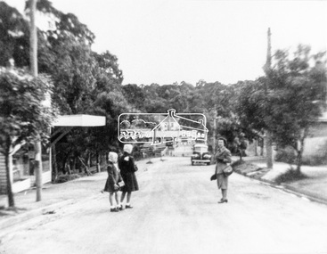
Negative - Photograph, Were Street, Montmorency, 8 Oct 1950
From left; Constance and Betty Dandy and possibly their mother, Mrs Dandy, standing in Were Street. Photos shows Smyth's Milk Bar and Montmorency Railway Station in distance; Tozer and Whiteways Grocer on left. Mrs Dandy ran a haberdashery store in Were St.This photo forms part of a collection of photographs gathered by the Shire of Eltham for their centenary project book,"Pioneers and Painters: 100 years of the Shire of Eltham" by Alan Marshall (1971). The collection of over 500 images is held in partnership between Eltham District Historical Society and Yarra Plenty Regional Library (Eltham Library) and is now formally known as the 'The Shire of Eltham Pioneers Photograph Collection.' It is significant in being the first community sourced collection representing the places and people of the Shire's first one hundred years.Digital image 120 format B&W negative Black and white printOne print copy inscribed on reverse: Montmorency Station 8-10-50 Smyths ? Milk Bar Girls Constance and Bettey Dandy ? Tozer and Whiteways Grocer on left ?sepp, shire of eltham pioneers photograph collection, montmorency, were street, betty dandy, constance dandy, milk bar, montmorency railway station, railway station, shopping centre, smyth's milk bar, tozer and whiteways grocer, were street shops -
 Eltham District Historical Society Inc
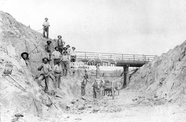
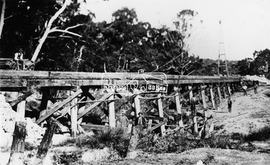
Negative - Photograph, Construction of Railway Line, Greensborough to Eltham, 1901
The Silver Street Bridge, 1901 Butty Gang workers excavate a rock cutting near the Silver Street bridge prior to laying of track. The Butty Gang system versus the Contract System was subject to public debate regarding cost benefits at the time of the Eltham line construction. Butty gang workers were a group of men who take a contract for a part of a work, as in the construction of railroads, etc., the proceeds being equally divided between them, with something extra to the foreman. Some hold picks, a couple of horses and carts are lined up probably for carting the broken rock away, dirt, rocks and shale lay at the bottom. A pair of small wooden buckets are evident, most likley to provide drinking water. The timber Silver Street bridge crosses the cutting in the background. The opening of the railway line from Heidelberg to Eltham took place on the 6th June 1902. Similiar to 810. Source: Mrs. Dandy, Montmorency and Miss McColl, 8 Anderson St., HeidelbergThis photo forms part of a collection of photographs gathered by the Shire of Eltham for their centenary project book,"Pioneers and Painters: 100 years of the Shire of Eltham" by Alan Marshall (1971). The collection of over 500 images is held in partnership between Eltham District Historical Society and Yarra Plenty Regional Library (Eltham Library) and is now formally known as the 'The Shire of Eltham Pioneers Photograph Collection.' It is significant in being the first community sourced collection representing the places and people of the Shire's first one hundred years.Digital image 120 format B&W negativeshire of eltham pioneers photograph collection, eltham, railway workers, 1901, butty gang, overpass, railway construction, railway line construction, silver street bridge -
 Eltham District Historical Society Inc
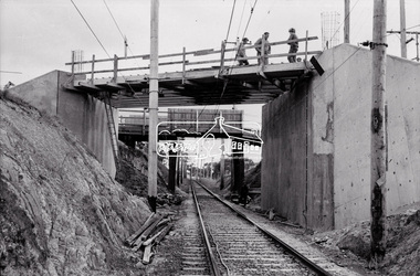
Negative - Photograph, Russell Yeoman, New road bridge under construction over railway line at junction of Sherbourne and Para Roads, Briar Hill, 1971
New bridge in foreground. Old bridge in background before demolition. This photo forms part of a collection of photographs gathered by the Shire of Eltham for their centenary project book,"Pioneers and Painters: 100 years of the Shire of Eltham" by Alan Marshall (1971). The collection of over 500 images is held in partnership between Eltham District Historical Society and Yarra Plenty Regional Library (Eltham Library) and is now formally known as the 'The Shire of Eltham Pioneers Photograph Collection.' It is significant in being the first community sourced collection representing the places and people of the Shire's first one hundred years.Digital image 35 mm B&W negativesepp, shire of eltham pioneers photograph collection, montmorency, briar hill, bridge, para road, railway bridge, railway line, road construction, sherbourne road, bridge construction -
 Eltham District Historical Society Inc
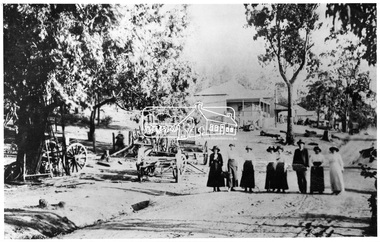
Negative - Photograph, Tom Prior, Main Road, Hurstbridge, c.1912
Seven women and one man strolling down Main road, Hurstbridge. They have possibly arrived for a visit on the train, when the railway line was extended from Eltham to Hurstrbridge in 1912. This photo is also contained in the Reynolds-Prior CollectionThis photo forms part of a collection of photographs gathered by the Shire of Eltham for their centenary project book, "Pioneers and Painters: 100 years of the Shire of Eltham" by Alan Marshall (1971). The collection of over 500 images is held in partnership between Eltham District Historical Society and Yarra Plenty Regional Library (Eltham Library) and is now formally known as 'The Shire of Eltham Pioneers Photograph Collection.' It is significant in being the first community sourced collection representing the places and people of the Shire's first one hundred years. The Reynolds family were early settlers in Research. The Reynolds/ Prior collection of photographs were taken by Tom Prior, the maternal uncle of Ivy Reynolds, around 1900 and the 60 photos in the album give a fine overview of many of the landmarks of Research and Eltham over 100 years ago. lvy lived in the family home for many years at 106 Thompson Cres Research. Ivy's father, Ernst Richard Reynolds and grandfather, Richard Reynolds, lived at the same address. Ivy's father Richard worked for Mr. Trail on his property in Research. Reynolds Road is named after the family. Mr Tom Prior (wife Eva) worked at the Melbourne zoo. He was very innovative and made his own camera, using the black cloth hood to exclude the light. The photographs are a reminder of the rural nature of Research and Eltham and its rich heritage.Digital image 4 x 5 inch B&W Negsepp, shire of eltham pioneers photograph collection, hurstbridge, main road, reynolds prior collection -
 Eltham District Historical Society Inc
Photograph, Railway Bridge construction between Eltham and Hurstbridge, c.1912
The railway was extended from Eltham to Hurstbridge in 1912. This bridge is most likely near Allendale Road, Diamond Creek. It was one of four original trestle bridges in the stretch north of Allendale Road, which were all burnt out in January 1969 (replaced by two steel bridges and two corrugated iron culverts).This photo forms part of a collection of photographs gathered by the Shire of Eltham for their centenary project book,"Pioneers and Painters: 100 years of the Shire of Eltham" by Alan Marshall (1971). The collection of over 500 images is held in partnership between Eltham District Historical Society and Yarra Plenty Regional Library (Eltham Library) and is now formally known as the 'The Shire of Eltham Pioneers Photograph Collection.' It is significant in being the first community sourced collection representing the places and people of the Shire's first one hundred years.Digital image One 4 x 5 inch B&W negative One 9 x 12.5 cm printshire of eltham pioneers photograph collection, hurstbridge, allendale road, hurstbridge railway extension, railway bridge, railway line construction, trestle bridge, diamond creek (creek) -
 Eltham District Historical Society Inc
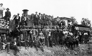
Photograph, First steam train to Hurstbridge
A large group of men of varying ages stand on or beside the first steam train to Hurstbridge. Two hold children on their laps. A small group of seven boys also gather for the photo. The line opened on 2 January 1912 and was officially opened in June.The photo commemorates the culmination of many years of community and political agitation for the extension of the railway line. 100 years later the Hurstbridge railway line remains a vital part of Melbourne's public transport network. This photo forms part of a collection of photographs gathered by the Shire of Eltham for their centenary project book, "Pioneers and Painters: 100 years of the Shire of Eltham" by Alan Marshall (1971). The collection of over 500 images is held in partnership between Eltham District Historical Society and Yarra Plenty Regional Library (Eltham Library) and is now formally known as 'The Shire of Eltham Pioneers Photograph Collection.' It is significant in being the first community sourced collection representing the places and people of the Shire's first one hundred years.Digital image Also black and white copy of original mounted photo (broken) printed on glossy photographic paper 30.5 x 40.5 cm; image size approx. 18.5 x 28 cm (One of 36 photos (5 with duplicate prints) from Kevin Patterson of Nillumbik Historical Society, no captions, subjects largely unknown but mostly of Diamond Creek area and people.)sepp, shire of eltham pioneers photograph collection, hurstbridge, steam train, railroads, group, hurstbridge railway line, steam engine, diamond creek, wattle glen, railway line -
 Eltham District Historical Society Inc
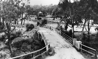
Negative - Photograph, View across bridge at Hurstbridge, Vic, c.1922
View across the new Monash bridge across the Diamond Creek at Hurstbridge looking towards the township, note steam train in centre background of image. Dated between the opening of bridge Nov. 1917 and provision of electric rail service Aug. 1926 - c.1922. Part of a slide show presentation "Bridges & Waterways of the Shire" by Russell Yeoman to the 13 September 1989 Society meeting. The presentation included slides of historic photos from the Shire of Eltham Pioneers collections as well as several recent views.This photo forms part of a collection of photographs gathered by the Shire of Eltham for their centenary project book ,"Pioneers and Painters: 100 years of the Shire of Eltham" by Alan Marshall (1971). The collection of over 500 images is held in partnership between Eltham District Historical Society and Yarra Plenty Regional Library (Eltham Library) and is now formally known as 'The Shire of Eltham Pioneers Photograph Collection.' It is significant in being the first community sourced collection representing the places and people of the Shire's first one hundred years.Digital image 4 x 5 inch B&W Negshire of eltham pioneers photograph collection, hurstbridge, bridge, steam train, diamond creek (creek), railway line, monash bridge -
 Eltham District Historical Society Inc
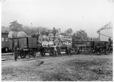
Photograph, Loading fruit trees at Hurstbridge Railway Station, 1914
Allwood Nurseries in Hurstbridge was operated by W.G (William George) Gray. He operated a well cultivated property under nursery healthy stock, principally apples, peaches, plums and cherries and sometimes potatoes. He grew seedling stock which he supplied to other local orchardists and the overseas market. This image is of railroad train wagons loaded with fruit trees at Hurstbridge Railway Station for export to New Zealand. Frederick George Hurst (bearded) sits on top of the load (aged 73 years). His son-in-law Willian Gray stands beside the wagon. This photo forms part of a collection of photographs gathered by the Shire of Eltham for their centenary project book, "Pioneers and Painters: 100 years of the Shire of Eltham" by Alan Marshall (1971). The collection of over 500 images is held in partnership between Eltham District Historical Society and Yarra Plenty Regional Library (Eltham Library) and is now formally known as 'The Shire of Eltham Pioneers Photograph Collection.' It is significant in being the first community sourced collection representing the places and people of the Shire's first one hundred years.Digital imagesepp, shire of eltham pioneers photograph collection, hurstbridge, allwood nurseries, frederick george hurst, w.g. gray, hurstbrdge railway station, william george gray, railroad trains, nurseries (plants), export, despatch, transport -
 Eltham District Historical Society Inc
Photograph, Excavating Railway Cutting to Hurstbridge
Labourers excavate a cutting for the new railiway extension from Eltham to Hurstbridge. Men are working with shovels and buckets, dropping dirt into horse and carts. A pile of newly cut sleepers sit on the sidelines waiting to be laid. The new extension is approx. seven miles in length and opened on 2 January, 1912.This photo forms part of a collection of photographs gathered by the Shire of Eltham for their centenary project book, "Pioneers and Painters: 100 years of the Shire of Eltham" by Alan Marshall (1971). The collection of over 500 images is held in partnership between Eltham District Historical Society and Yarra Plenty Regional Library (Eltham Library) and is now formally known as 'The Shire of Eltham Pioneers Photograph Collection.' It is significant in being the first community sourced collection representing the places and people of the Shire's first one hundred years.Digital imagesepp, shire of eltham pioneers photograph collection, diamond creek, hurstbridge, wattle glen, railway line construction, railroad construction workers, railroad construction -
 Eltham District Historical Society Inc
Photograph, Hurstbridge - Showing Railway Station
View overlooking the township and surrounding hills of Hurstbridge. The new railway line and station and accompanying works are central. The extension from Eltham to Hurstbridge opened on 2 January 1912.This photo forms part of a collection of photographs gathered by the Shire of Eltham for their centenary project book, "Pioneers and Painters: 100 years of the Shire of Eltham" by Alan Marshall (1971). The collection of over 500 images is held in partnership between Eltham District Historical Society and Yarra Plenty Regional Library (Eltham Library) and is now formally known as 'The Shire of Eltham Pioneers Photograph Collection.' It is significant in being the first community sourced collection representing the places and people of the Shire's first one hundred years.Digital imagesepp, shire of eltham pioneers photograph collection, diamond creek, hurstbridge, railway station, railroad, railway line -
 Eltham District Historical Society Inc
Negative - Photograph, Eltham, Main Road near station, c.1910
View looking north along Main Road, Eltham from near present day Dudley Street. On the immediate left is the railway station. The large weatherboard building on the bend (opposite present-day Arthur Street) with signs for General Store, Refreshments and Summer Drinks painted on the side is Luther and Ada Haley’s General Store and Bakery, built 1902. This was the first building in what is now Eltham’s present shopping town centre. Haley previously ran the General Store and Bakery on the corner of Main Road and York Street until his lease expired and the premises were bought by Mrs Sarah Burgoyne in 1902. The store later was known as Staff's Store. Followed by the saleyards, entrance to station, slaughter yard and William J Capewell’s butcher shop. Contained within the saleyards facing the street, a small shelter with the name H.H. Clark upon it. Horace Harold Clark was the son of Eltham State School’s first Head Teacher, David George Clark. As well as being a farmer, he was an Estate Agent and conducted auction sales, presumably from this shelter. On the eastern (right) side of Main Street is Haley’s Paddock, which was used on occasions for community picnics. Capable of holding 10,000 people, with ample shade and hilly surroundings it was an ideal place for any community gathering such as the State Schools’ Picnic in 1904. A worker from the bakery store is standing in the gateway at the rear of the store observing the photographer. People in the ‘Sunday Best’ are milling in front of the bakery or strolling down the centre of Main Road. The picture was most likely taken on a Sunday. With the opening of the railway to Eltham in 1902, Melbourne residents would regularly enjoy a Sunday excursion journey on the train to Eltham for a day’s outing to the countryside or beyond to Hurstbridge from 1912 when the railway was extended. Picture dated as c.1910 based on similar picture published in the Weekly Times, Feb. 1912. Cross Ref: 609 (looking south), 612, 611 (later stage), 613.Negative black and white film 120 6x9 format 2 stripsAgfa APX 100baker, butcher, eltham, eltham railway station, eltham sale yards, eltham slaughter yard, eltham town centre, general store, haley's paddock, hot water, luther haley, luther haley general store, m.m. clark, main road, railway station, shire of eltham pioneers photograph collection, shops, sign, staffs general store, summer drinks, w.j. capewell -
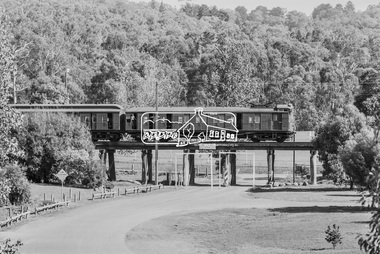
 Eltham District Historical Society Inc
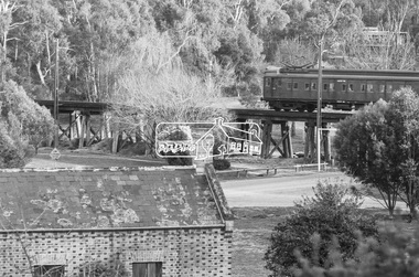
Photograph, George Coop, A Tait (Red Rattler) train bound for Princes Bridge crosses the Eltham Railway Trestle Bridge, c.1981, 1981
Shillinglaw Cottage in Eltham Common and Panther Place can be seen through the bridge span.Digital TIFF file Scan of 35mm Ilford FP4 black and white transparencyeltham common, eltham trestle bridge, panther place, red rattler, shillinglaw cottage, tait train -
 Eltham District Historical Society Inc
Photograph, George Coop, A Tait (Red Rattler ) train crosses the Eltham Railway Trestle Bridge at Panther Place, Eltham, 7-8 February 1981, 1981
Eltham Central Park viewed through the bridgeDigital TIFF file Scan of 35mm Ilford FP4 black and white transparency435m, eltham central park, eltham trestle bridge, hurstbridge line, panther place, red rattler, tait train -
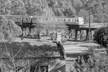 Eltham District Historical Society Inc
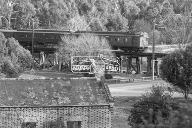
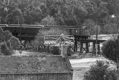
Photograph, George Coop, Hitachi train crossing Eltham Railway Trestle Bridge, c.October 1982, 1982
Note Shillinglaw Cottage in foreground and Panther Place.Digital TIFF file Scan of 35mm Ilford FP4 black and white transparencyeltham trestle bridge, hitachi electric train (1972-2014), hurstbridge line, panther place, shillinglaw cottage -
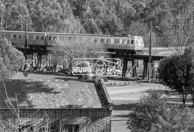 Eltham District Historical Society Inc
Photograph, George Coop, Hitachi train crossing Eltham Railway Trestle Bridge, c.October 1982, 1982
Note Shillinglaw Cottage in foreground and Panther Place.Digital TIFF file Scan of 35mm Ilford FP4 black and white transparencyeltham trestle bridge, hitachi electric train (1972-2014), hurstbridge line, panther place, shillinglaw cottage -
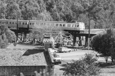
 Eltham District Historical Society Inc
Photograph, George Coop, Tait (Red Rattler) train crossing Eltham Railway Trestle Bridge, c.October 1982, 1982
Note Shillinglaw Cottage in foreground and Panther PlaceDigital TIFF file Scan of 35mm Ilford FP4 black and white transparencyeltham trestle bridge, hurstbridge line, panther place, red rattler, shillinglaw cottage, tait train -
 Glen Eira Historical Society
Album - Album page, Hotham Street, Circa 1972
This photograph is part of the Caulfield Historical Album 1972. This album was created in approximately 1972 as part of a project by the Caulfield Historical Society to assist in identifying buildings worthy of preservation. The album is related to a Survey the Caulfield Historical Society developed in collaboration with the National Trust of Australia (Victoria) and Caulfield City Council to identify historic buildings within the City of Caulfield that warranted the protection of a National Trust Classification. Principal photographer thought to be Trevor Hart, member of Caulfield Historical Society. Most photographs were taken between 1966-1972 with a small number of photographs being older and from unknown sources. All photographs are black and white except where stated, with 386 photographs over 198 pages.Victorian Heritage Database - Hotham Street Road Overbridge HO116 Heritage Overlay - City of Glen Eira https://vhd.heritagecouncil.vic.gov.au/places/43557 (as of 04/07/2021) The Hotham Street road overbridge is located on the Sandringham railway line between Ripponlea and Elsternwick railway stations. It is presumed to have been built by contractors Sharp and Campbell who signed a contract on 25th . November, 1881 to construct a second line of railway between Windsor and Elsternwick. This contract was completed during 1882 and the bridge may have been designed in the year when Robert Watson took over from William Elsdon as engineer in chief for the Victorian railways. It is historically, aesthetically and technically significant. It is historically significant (Criterion A) to the extent that it demonstrates the standards of construction adopted by the Victorian Railways Department when it rebuilt the lines acquired from the private railway companies, (compare the Geelong and Melbourne Railway Co's line from Newport to Geelong, acquired in 1860). It is aesthetically significant (Criterion E) as an intact nineteenth century structure of its type, many similar girder bridges having been renewed with concrete girders in recent years. The bluestone abutments demonstrate high standards of stone masonry and are representative of Departmental work of the period. This bridge forms one of a group of historic structures on the railway to Brighton Beach and therefore contributes to the line's cultural importance as a whole. The survival of the riveted iron girders with their bellied angle iron struts is important since these elements are representative of the civil engineering practices of the Victorian Railways at the time and constitute the technical significance (Criterion F) of the structure.Page 96 of Photograph Album with three photographs (one portrait and two landscape) from Hotham Street - two external views of one house and a railway bridge.Handwritten: Hotham Street [top right] / 112 HOTHAM ST [under top left photo] / BRIDGE OVER SANDRINGHAM RAILWAY [under top right photo] / 112 HOTHAM ST CNR MELBY AVE [under bottom left photo] / 96 [bottom right]trevor hart, elsternwick, hotham street, caulfield, houses, brick, bay windows, verandahs, railway bridges, tunnels, gardens, bluestone, civil engineering, victorian railways, sharp and campbell, contractors -
 Glen Eira Historical Society
Album - Album page, Neerim Road, Circa 1972
This photograph is part of the Caulfield Historical Album 1972. This album was created in approximately 1972 as part of a project by the Caulfield Historical Society to assist in identifying buildings worthy of preservation. The album is related to a Survey the Caulfield Historical Society developed in collaboration with the National Trust of Australia (Victoria) and Caulfield City Council to identify historic buildings within the City of Caulfield that warranted the protection of a National Trust Classification. Principal photographer thought to be Trevor Hart, member of Caulfield Historical Society. Most photographs were taken between 1966-1972 with a small number of photographs being older and from unknown sources. All photographs are black and white except where stated, with 386 photographs over 198 pages. "Edenkillie" was the home of Frederick Jowett, Caulfield's shire secretary and town clerk from 1887 to 1921. The Outer Circle Railway's Oakleigh section opened 1890 and closed 1895. Victorian Heritage database (as of 26/10/2021) HO45 Edenkillie https://vhd.heritagecouncil.vic.gov.au/places/35545 "Edenkillie" at 37 Neerim Road, Glenhuntly, is a substantial two storeyed polychrome brick villa, built for Frederick Jowett, municipal secretary, in 1890. It has aesthetic, historical and social significance. "Edenkillie's" aesthetic value derives from its survival as a substantially intact example of a common villa form expressed in polychrome brickwork. Its historical significance lies in its association with Frederick Jowett, Shire of Caulfield secretary and town clerk for over three decades. Its social significance is derived from the building's ability to demonstrate the kind of lifestyle which a local government administrator could enjoy during the Land Boom.Page 145 of Photograph Album with four landscape photographs from Neerim Road: two photographs of No 37 and two of the Outer Circle Railway Reserve.Handwritten: Neerim Road [top left] / 37 NEERIM ROAD 1OCT 1972 [under top left photo] / 37 NEERIM RD 1 OCT 1972 [under top right photo] / OUTER CIRCLE RAILWAY RESERVE MURRUMBEENA [under bottom left photo] / 145 [bottom left]trevor hart, neerim road, murrumbeena, caulfield, edenkillie, glen huntly, polychrome brick, mansions, frederick jowett, town clerks, shire of caulfield, outer circle railway, railways, parks and reserves, outer circle railway reserve, cast iron work, verandahs, balconies -
 Glen Eira Historical Society
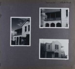
Album - Album page, Balranald, Poath Road, Circa 1972
This photograph is part of the Caulfield Historical Album 1972. This album was created in approximately 1972 as part of a project by the Caulfield Historical Society to assist in identifying buildings worthy of preservation. The album is related to a Survey the Caulfield Historical Society developed in collaboration with the National Trust of Australia (Victoria) and Caulfield City Council to identify historic buildings within the City of Caulfield that warranted the protection of a National Trust Classification. Principal photographer thought to be Trevor Hart, member of Caulfield Historical Society. Most photographs were taken between 1966-1972 with a small number of photographs being older and from unknown sources. All photographs are black and white except where stated, with 386 photographs over 198 pages. Originally named Crofthead or The Croft Head, later changed to Balranald according to Melbourne Mansions database.From Victorian Heritage Database citation for HO136 13 Poath Street MURRUMBEENA https://vhd.heritagecouncil.vic.gov.au/places/35389 as at 30/10/2020 "Croft Head" is situated at no. 13 Poath Road, Murrumbeena, and was built in 1887 for the accountant Edward Tweddell. It is historically and aesthetically significant. It is historically significant (Criterion A) as a substantial and now rare (Criterion B) surviving late Victorian villa residence east of Booran Road within the Municipality and demonstrating the attraction of Melbourne's rural fringe as a residential location rendered accessible by the opening of the railway between South Yarra and Oakleigh in 1879. It is aesthetically significant (Criterion E) as one of the Municipality's finest late Victorian polychrome brick villas, comparing with ''Fresch'' and ''Monkleigh'' both erected in 1899 at nos. 11 and 12 Gladstone Parade, Elsternwick respectively, ''Hartington'' (1888) at 15 Gladstone Parade and ''Hengar'' (1889) at no. 356 Glen Eira Road, Caulfield South. Elements of stylistic significance include the ornamentation of the brickwork in polychrome work with tiled panels, the effect of the banding being especially striking and representative of the period.Page 166 of Photograph Album with three photographs of Balranald on Poath Road.Handwritten: "Balranald" 13 Poath Road [top right] / 166 [bottom right]trevor hart, decorative brackets, chimneys, verandah, porch, poath road, arches, cast iron columns, return verandah, croft head, balranald, victorian villa, restoration, 1880's, edward tweddell, murrumbeena, hughesdale, cast iron frieze, victorian style, cast iron work, rendered brick, house names, polychrome brick, poath street, crofthead, the croft head -
 Glen Eira Historical Society
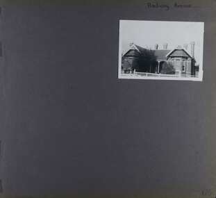
Album - Album page, Railway Avenue (ie Railway Parade), Circa 1972
This photograph is part of the Caulfield Historical Album 1972. This album was created in approximately 1972 as part of a project by the Caulfield Historical Society to assist in identifying buildings worthy of preservation. The album is related to a Survey the Caulfield Historical Society developed in collaboration with the National Trust of Australia (Victoria) and Caulfield City Council to identify historic buildings within the City of Caulfield that warranted the protection of a National Trust Classification. Principal photographer thought to be Trevor Hart, member of Caulfield Historical Society. Most photographs were taken between 1966-1972 with a small number of photographs being older and from unknown sources. All photographs are black and white except where stated, with 386 photographs over 198 pages. From Victorian Heritage Database citation for HO57 Alnwick, 11 Railway Parade Murrumbeena https://vhd.heritagecouncil.vic.gov.au/places/35369 as at 30/10/2020 Alnwick" is situated at no. 11 Railway Parade, Murrumbeena, and was built for Sir James Patterson, former Commissioner of Public Works and Railways and Premier and Chief Secretary at the time. It is historically and aesthetically significant. It is historically significant (Criterion A) as the home of a former Premier and MLA who held a multitude of senior positions during his term of office spanning between 1870 and 1895. These positions included Commissioner of Public Works, Vice President of the Board of Land and Works, Postmaster General, Commissioner of Railways and Commissioner of Trade and Customs and Minister of Railways. Importantly, he held these offices during the period of Colonial expansion leading up to the economic crash of the early 1890s. It is aesthetically significant (Criterion E) as an early example of the Queen Anne style in Glen Eira and as an isolated early building facing the railway station in Murrumbeena.Page 170 of Photograph Album with one photograph of a house on Railway Avenue.Handwritten: Railway Avenue [top right] / 170 [bottom right]trevor hart, chimneys, verandah, porch, 1890's, alnwick, railway parade, sir james patterson, james patterson, single storey, murrumbeena station, red brick, gable, murrumbeena, railway avenue, victorian style, house names, queen's avenue, queen anne style, protruding bay windows, premiers, polychrome bricks -
 Glen Eira Historical Society
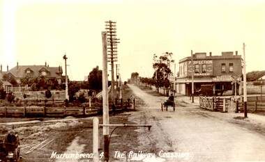
Article - MURRUMBEENA ROAD RAILWAY CROSSING
This file contains eleven items: 10 original photographs and 1 newspaper cutting. 1/A black and white photograph titled in the format of the shot ‘Murrumbeena. 4. The Railway Crossing’, date unknown, estimated to be 1905. Donated by the Hermes Studio on 19/11/1980. 2/A black and white photograph with a white border of the signal box at Murrumbeena Station by R.P Dunbar dated 16/03/1979 with a handwritten description on the back. 3/A black and white photograph with a white border of the interior of the Murrumbeena Train Station Signal box with a man identified as Michael sitting, taken by R.P Dunbar dated 17/03/1979 with a handwritten description on the back. 4/A black and white photograph with a white border of the removal the boom gates at Murrumbeena Train Station railway crossing. Taken by R.P Dunbar printed 28/04/1979, which includes a handwritten description on the back. 5/A black and white photograph with a white border of the removal of the boom gates taken by R.P Dunbar dated 29/04/1979, with a handwritten description on the back. 6/A black and white photograph with a white border of Murrumbeena Road Crossing during the removal of the boom gates taken by R.P Dunbar printed 29/04/1979. This includes a hand written description on the back. 7/A black and white photograph with a white border of the Murrumbeena Road Railway Crossing during the removal of the boom games dated 29/04/1979, taken by R.P Dunbar, with a hand written description of the photograph on the back. 8/A black and white photograph with a white border of Murrumbeena Road Crossing during the removal of the boom gates dated 29/04/1979 taken by R.P Dunbar with a handwritten description on the back. 9/A black and white photograph with a white border of Murrumbeena Road Railway Crossing with a new boom barrier replacing the boom gates, taken by R.P Dunbar dated 29/04/1979. Including a handwritten description on the back. 10/A black and white photograph with a white border of Murrumbeena Railway Station, Murrumbeena Road with the replacement boom barriers in place, taken by R.P Dunbar dated 29/04/1979. Including a hand written description on the back. 11/A newspaper article titled ‘Boom gates to create road Chaos’ written by Adam Carey from ‘The Age’ dated 29/11/2011. This includes a coloured photograph of the Murrumbeena Road Level Crossing taken by Michael Clayton Jones, and a map of the train line and level crossing between Carnegie Station and Hughesdale Station. The article makes educated predictions based on VicRoads Studies of future implications on road traffic unless more level crossings are removed. In particular the Dandenong corridor and Murrumbeena Road crossings are identified as high priority on the list of potential crossings which may have to be removed. Additionally the article discusses options the government has in addressing the dilemma, and the opinion of a Carnegie pharmacist Gerald Galatis whose business is near the level crossing on Koornang Road.transport, railway crossing, koornang road, railways, level crossing, gates, trains, road crossing, transport establishments, signal boxes, murrumbeena railway station, dunbar r.p., murrumbeena road, carnegie station, railway lines, railway buildings, road traffic, galatis gerald, construction sites, poath road, neerim road, hermes studio -
 Glen Eira Historical Society
Document - GLEN HUNTLY (HISTORY OF)
This file contains one item: 1/A loose-leaf, 23-page document titled ‘The History of Glen Huntly’, by Alfred R. Jones, dated 20/06/1991, describing the history of the suburb. The author has drawn heavily from the 4 sources noted in the bibliography. Subjects covered include the ship the suburb is named after, the suburb’s State School, the suburb’s churches, the Rosstown Railway and Sugar Mill, the origin of the name of Carnegie, the suburb’s aerodrome, and the beautification of the Glen Huntly Shopping Centre. The final 12 pages consist of 9 appendices relating to the aforementioned subjects. Appendix A is a typewritten letter from Ron McLeod, secretary of the Place Names Committee, to Mr. D. R. Aylen, CEO of the City of Caulfield, notifying the latter of the alteration of the name ‘Glenhuntly’ to ‘Glen Huntly’. Appendix B is a list of the ministers of St. David’s Uniting Church from its formation in 1916 to the present. Appendix C identifies the persons portrayed in St. David’s stained glass windows. Appendix D is a poster announcing the auction of 41 blocks of land between Hawthorn and Bambra Road formerly owned by William Ross, plus a map identifying said land blocks and anither fir locality. Appendix E is an A4 plan of the Rosstown Railway. Appendix F is a drawing of the Rosstown Sugar Mill. Appendix G is a poem titled ‘The Swagman’s Retreat’, by Herb Arnott, about the failure of the Mill. Appendix H is a map of Caulfield’s horse tramways plus a list of opening and closing dates. Appendix J is a list of streets explaining the meanings of their names.glen huntly, glenhuntly, local history, ‘glen huntly’ (ship), ‘glen huntlely’ (ship), quarantine stations, glen huntly road, lake street, mernda avenue, glen huntly state school no. 3703, ormond francis, ormond, garden avenue, grange road, churches, congregational church, glen huntly presbyterian church, st. david’s, st. david’s uniting church, anglican church, jenkin william ‘boss’, methodist church, wattle avenue, smith a. w. mr., glen huntly post office, glen huntly road, king f. l. mr., uniting church, child care centre, presbyterian church of eastern australia, glen huntly methodist church, sun aria, miller mary, stained glass, phrenologists, trinity congregational church, primitive methodists, ‘the victorian independent’, mercy mr., greek orthodox original old calendar church, wanalta road, salvation army, halls, myrtle street, catholic church, st. anthony’s roman catholic church, foundation stones, neerim road, mannix archbishop, st. agnes’ anglican church, booran road, sunday schools, clergy residences, ‘see’ anglican news magazine, lees archbishop, booth archbishop, glen huntly presbyterian church, el nido grove, tennis courts, bollard v. w. right rev., waratah avenue, royal avenue, munster avenue, james street, rothschild street, peace memorial organ, singers, bremner marie, scotland betty, carden joan, rosstown railway, south caulfield, plants, marata road, curraweena road, bambra road, ross william murray, ross leila, ross constance, vautin constance, ‘the grange’, north road, leila road, wild cherry road, caulfield roads board, elsternwick, land sales, sugar mills, koornang road, woornack road, elsternwick railway station, riddell parade, clarence street, dover street, oakleigh road, murrumbeena crescent, carlisle crescent, railways, trains, parks and reserves, caulfield council, sussex street, caulfield city council, swamps, rosstown sugar mill, rosstown estate, ‘the swagman’s retreat’, arnott herb, rosstown, carnegie, ‘ross’s folly’, carnegie andrew, rosstown hotel, dandenong road, rosstown road, rosstown plate horse race, caulfield racecourses, ames avenue, rosstown court, hostels, murrumbeena, cinemas, innovations (cabinetry film), films, music, pianos, manchester grove, safeway store, squash courts, airports, lord reserve, aeroplanes, air navigation act 1921, neville street, larkin sopwith aviation company of australasia, lyons street, morgan street, bookmakers, nightsoil, poultry, weatherboard buildings, glen huntly railway station, rosedale avenue, rifle clubs, scout groups, 1st glen huntly troop, ana, dowding jack mr., glen huntly infant welfare and family planning clinic, vermador private hospital, watson grove, rowlands (drapers), bones plant nursery, caulfield railway station, bridges, trams, horse tramways, glen eira road, elsternwick railway station, kooyong road, aboriginal peoples, truganini road, hannan lyn mrs. (urban planning officer), glen huntly shopping centre, sculptures, street beautification scheme, “flying the yellow flag”, moore olive, “return to rosstown”, jowett d. f., weickhardt i. s., “from sand swamp and health”, murray peter r., wells john c., caulfield historical society, newsletters, place names committee, mcleod ron, aylen d. r. mr., jones hugh rev., king joseph, scarfe james, vertigan sidney, vertigan earle, rance victor, flavell cameron, denholm robin, moorhead ken, taliai siupeli, eccles james leslie, little agnes, hutchins william r., dickie may a., gordon ivey agnes, theobald a. a. mrs., brownbill lloyd norman, ash georgette, land sales, auctions, messrs. crews & arkle, street names -
 Federation University Historical Collection
Photograph, Noel L. Harvey, Yendon Railway Station, 1968, 03/12/1968
Buninyong had no railway station so residents would travel to Yendon to catch the train. The Yendon Railway Station building was demolished soon after this photograph was taken. The bluestone was purchased by John Vernon, and was used to construct retaining walls in a garden enclosure between the first two buildings at the new Ballarat Institute of Advanced Education campus at Mt Helen. This is now known as the courtyard between building 'F' and building 'G' at the University of Ballarat mt Helen Campus. The following article was published in the Ballarat Courier on 06 December 1968. 'Yendon Station to be demolished - The old bluestone railway station at Yendon is to be demolished. C.A.D. Fisken told Buninyong Shire Council of the proposal at its meeting yesterday. Fortunately, he said, the beautiful stonework would not be lost. It would be used and incorporated in the new School of Mines building at Mt Helen. the retention of the century-old building was the subject of representations by Council to the Railways following the closure of the station for goods traffic 'some time ago'. The building had also been noted by the National Trust as one of special interest. The Railways Department advised the meeting that an inspection had been made at the Yendon level crossing, but no recommendation could be made at present for installation of flashing light signals.'Bluestone building with dressed bluestone door and window jambs and chimney. The roof is corrugated iron. The platform edge is also of bluestone construction. The building is the former Yendon Railway Station (now demolished) on the Ballarat -Geelong main line (the original Melbourne to Ballarat mainline). When the line was opened, this station may have been originally called Buninyong as it was built a number of years before the Ballarat to Buninyong branch line was built. This this has subsequently caused some confusion. The station was later renamed Yendon. Verso in blue ballpoint pen 'No 47 Yendon Railway Stn' Stamped in purple ink 'N.L. Harvey & Son, Photographers, 131 Sturt Streeet Ballarat, Phone 25766, After hours 23397, Will photograph anywhere anytime any place. (in pen 3/12/68),university of ballarat, ballarat institute of advanced education, yendon, railway, bluestone, john vernon -
 Flagstaff Hill Maritime Museum and Village
Functional object - Nail, ca. 1855
When the ship Schomberg was launched in 1855, she was considered the most perfect clipper ship ever to be built. James Blaine’s Black Ball Line had commissioned her to be built for their fleet of passenger liners. At a cost of £43,103, the Aberdeen builders designed her to sail faster than the quick clippers designed by North American Donald McKay. She was a three masted wooden clipper ship, built with diagonal planking of British oat with layers of Scottish larch. This luxury vessel was designed to transport emigrants to Melbourne in superior comfort. She had ventilation ducts to provide air to the lower decks and a dining saloon, smoking room, library and bathrooms for the first class passengers. At the launch of Schomberg’s maiden voyage, her master Captain ‘Bully’ Forbes, drunkenly predicted that he would make the journey between Liverpool and Melbourne in 60 days. Schomberg departed Liverpool on 6 October 1855 with 430 passengers and 3000 tons cargo including iron rails and equipment intended the build the Geelong Railway and a bridge over the Yarra from Melbourne to Hawthorn. The winds were poor as Schomberg sailed across the equator, slowing her journey considerably. She was 78 days out of Liverpool when she ran aground on a sand-spit near Peterborough, Victoria, on 27 December; the sand spit and the currents were not marked on Forbes’s map. Overnight, the crew launched a lifeboat to find a safe place to land the ship’s passengers. The scouting party returned to Schomberg and advised Forbes that it was best to wait until morning because the rough seas could easily overturn the small lifeboats. The ship’s Chief Officer spotted SS Queen at dawn and signalled the steamer. The master of the SS Queen approached the stranded vessel and all of Schomberg’s passengers were able to disembark safely. The Black Ball Line’s Melbourne agent sent a steamer to retrieve the passengers’ baggage from the Schomberg. Other steamers helped unload her cargo until the weather changed and prevented the salvage teams from accessing the ship. Local merchants Manifold & Bostock bought the wreck and cargo, but did not attempt to salvage the cargo still on board the ship. They eventually sold it on to a Melbourne businessman and two seafarers. After two of the men drowned when they tried to reach Schomberg, salvage efforts were abandoned. In 1975, divers from Flagstaff Hill, including Peter Ronald, found an ornate communion set at the wreck. The set comprised a jug, two chalices, a plate and a lid. The lid did not fit any of the other objects and in 1978 a piece of the lid broke off, revealing a glint of gold. As museum staff carefully examined the lid and removed marine growth, they found a diamond ring, which is currently on display in the Great Circle Gallery. Flagstaff Hill also holds ship fittings and equipment, personal effects, a lithograph, tickets and photograph from the Schomberg. Most of the artefacts were salvaged from the wreck by Peter Ronald, former director of Flagstaff Hill. The Schomberg, which is on the Victorian Heritage Register (VHR S612), has great historical significance as a rare example of a large, fast clipper ship on the England to Australia run, carrying emigrants at the time of the Victorian gold rush. She represents the technical advances made to break sailing records between Europe and Australia. Flagstaff Hill’s collection of artefacts from the Schomberg is significant for its association with the shipwreck, The collection is primarily significant because of the relationship between the objects, as together they have a high potential to interpret the story of the Schomberg. It is archaeologically significant as the remains of an international passenger Ship. It is historically significant for representing aspects of Victoria’s shipping history and for its association with the shipwreck and the ship, which was designed to be fastest and most luxurious of its day Copper nail with petrified wooden section attached. There is a washer on the end of the nail. It is covered in verdigris. The nail was recovered from the wreck of the Schomberg.flagstaff hill, warrnambool, shipwrecked-coast, flagstaff-hill, flagstaff-hill-maritime-museum, maritime-museum, shipwreck-coast, flagstaff-hill-maritime-village, petrified wood, schomberg, copper nail, clipper ship, black ball line, 1855 shipwreck, aberdeen clipper ship, captain forbes, peterborough shipwreck, ss queen, ship's nail, nail in wood sample -
 Federation University Historical Collection
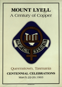
Poster, Mt Lyell Mining and Railway Co Ltd Centennial Celebration, 1993
Laminated poster advertising the Mt Lyell Mining and Railway Company Limited Centennial Celebrations taking place in Queenstown 26th to 29th March 1993 'Mt Lyell A Century in Copper'.mt lyell, mining, centennial, copper 100 year -
 Federation University Historical Collection
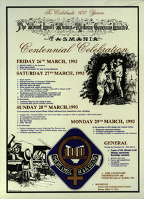
Poster, Mt Lyell Mining and Railway Company Centennial Celebration, 1993
Laminated poster advertising events associated with the Mt Lyell Mining and Railway Company Limited Centennial Celebrations taking place from Friday 26th March to Monday 29th March 1993.mt lyell, mining, centennial, -
Federation University Historical Collection
Document, Albert E. Stohr, Curriculum Vitae of A.E.Stohr, 1970, 19/01/1970
Albert E. Stohr was a member of the Council of the Ballarat School of Mines for 24 years, a member of the Council of the Ballarat grammar School for 24 years, represented all Provincial Sewerage Authorities in Victoria on the Plumbers and gasfitters registration Board of Victoria for 25 years, member of the Institution of Engineers (Australia) for 46 years, member of the Association of Professional Engineers of Australia for 22 years, and chairman of the Ballarat Group of the Association . Member of the Rotary Club of Ballarat for 24 years, and many other organisational.Five foolscap pages relating to the education and career of Albert Edward Stohr. Work places include: Broken Hill Proprietary Co. Ltd; Victorian Railways Construction Branch; Melbourne & Metropolitan Board of Works; Sewerage and Main Drainage Branch; Water Supply Branch; United States Army Services of Supply; Department of the Australian Army; Ballarat Water Commissioners; Ballarat Sewerage Authority. His projects include the White Swan Reservoir, Gong Gong Reservoir Spillway Channel; Installation of Venturi Meters at Brown Hill; Sewerage treatment Works; Nightsoil Dumping and Pan Washing Depot. stohr, bert stohr, a.e. stohr, white swan reservoir, engineering alumni, engineer, ballarat school of mines.