Showing 3220 items
matching road map
-
 Nhill Aviation Heritage Centre
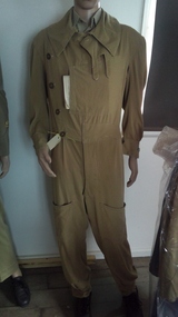
Summer flying suit, boots, leather helmut and goggles
This clothing was worn by Merv while flying as navigator in B24 bombers from northern Australia in 1945Cotton khaki colour overall style flying suit with four large buttons and map pouch. Black leather flying boots with lamb skin lining and leather strap and buckle at top. Leather flying helmet and goggles. -
 Nhill Aviation Heritage Centre
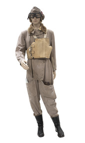
Uniform - Flying Suit, 1941
The Sidcot Pattern Flying Suit was the general suit used by the British AM (Air Ministry) during WW2. This suit dated 1941. Used by the RAF and the RAAF.Khaki flying suit with map pocket. Zips on front right side and sleeves. Lambswool collar -
 Nhill Aviation Heritage Centre
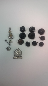
Buttons, Variety of airforce buttons
These buttons and badges belonged to Frank Seddon, an airforce pilot during World War 11, father of Nhill resident Pat Beacom.5 black 25 mm diameter buttons and 4 black 17mm diameter buttons with crown and eagle logo. RSL lapel badge , and RSL pin badge. Brown Australian Military Forces button 20 mm diameter, with crown and map of Australia inscribed on it 2 smaller slightly damaged buttons. airforce, buttons, seddon, wwii, ww2 -
 Nhill Aviation Heritage Centre
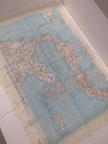
Map - Silk Map, No. 24 south celebes, c1942
... Nhill Aviation Heritage Centre 1 Aerodrome Road Nhill ...Silk maps produced by the USA for the Pacific warWhite woven silk material with printed map and text North Celebes print on the reverse side South CelebesNo. 24 South Celebesusa, us army air force, silk, map, celebes, saam, -
 Nhill Aviation Heritage Centre
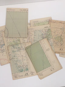
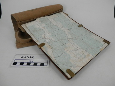
Map - Aeronautical Maps x 9, May 1943
Typical of the maps used during navigation training here at Nhill during WW2Aeronautical maps of Victoria, Printed on light card green text and markingsThird Edition May 1943, Sheet K8, Australian Aeronautical Map, Equatorial scale 1:1000,000map, aeronaughtical map, navigation -
 Bendigo Military Museum
photograph - Cartographic Squadron Production – Army Survey Regiment, Fortuna, c1980
This collection of 12 photos was most likely taken in 1980. The photos were most likely taken in Cartographic Squadron’s Ante Room, the Attic and small offices on the top floor of Fortuna Villa. The computer based Editwriter typesetting system was introduced in 1975 as a replacement to the aging Fotosetter machine. It was operated by a specialised technician, who generated a large variety of map type styles and sizes quickly and reliably, as well as text panels. CPL Richards performed this task for several years and in photo .1P and .2P is reading off a type order next to the computer monitor. Output on Copy proof adhesive backed stripping type film replaced messy wax and spray adhesives in 1978. The Editwriter capability supported all RASvy units and contractor type setting requirements. Scribing was the cartographic process of drafting features such as drainage, relief, vegetation, roads and culture on specially coated map reproduction material. The cartographic technician scribed out the map feature such as a contour to a specified line width on the map sheet, using a tool affixed with a sapphire tipped cutter. The quality control edit (Proving) stage of map production was the first opportunity to inspect a proof of the map independently and systematically. Proving tasks were carried out by technicians conversant of the map product specification and task requirement, however, was not involved in its production. Corrections were identified, marked up and sent to back to the correcting section or contractors. Terrain Embossing was a manual map production technique to produce hill shading on medium to small scale graphics and air charts. SPR John Martin is seen in photos .8P to.10P using a fine embossing metal stylus to push down on the drainage impression on a thin malleable opaque plastic material (AK Poligraphy). Ridge lines were then pushed down using the contour impression as a guide, on the opposing side of the AK Poligraphy to create a 3D plastic model terrain effect. The map impression was sprayed with white paint and photographed to create a contone tone hill shade. SPR Gina (Coore) Neilson is seen in photo .11P washing a contone positive of a land mass in a solution. The contone components were registered to the map sheet, as shown in photo .12P and masked using an air brush and a halftone negative was then created. The terrain embossing method of producing hill shading was more efficient to produce than previous specialised artistic methods such pencil/eraser and air brush. Furthermore, a more consistent enhancement of terrain on charts was achieved between technicians.This is a set of 12 photographs of Cartographic Squadron performing four map production tasks at the Army Survey Regiment, Fortuna, Bendigo c1980. The first ten photographs were on 35mm negative film and were scanned at 96 dpi. Photos .11P and .12P were on photographic paper and scanned at 300 dpi. They are part of the Army Survey Regiment’s Collection. .1) - Photo, black & white, c1980, Editwriter typesetter, CPL Paul Richards. .2) - Photo, black & white, c1980, Editwriter typesetter, CPL Paul Richards. .3) - Photo, black & white, c1980, Scribing contours on a RAAF Chart, SPR Megan (McBurney) Reynolds. .4) - Photo, black & white, c1980, Scribing contours on a RAAF Chart, SPR Megan (McBurney) Reynolds. .5) - Photo, black & white, c1980, Scribing contours on a RAAF Chart, SPR Rod Skidmore. .6) - Photo, black & white, c1980, Scribing contours on a RAAF Chart, SPR Rod Skidmore. .7) - Photo, black & white, c1980, Formal quality control edit (Proving), CPL Ian Belmont. .8) - Photo, black & white, c1980, Hill Shade Terrain Embossing, SPR John Martin. .9) - Photo, black & white, c1980, Hill Shade Terrain Embossing, SPR John Martin. .10) - Photo, black & white, c1980, Hill Shade Terrain Embossing, SPR John Martin. .11) - Photo, black & white, c1980, Hill Shade Terrain Embossing, SPR Gina (Coore) Neilson. .12) - Photo, black & white, c1980, Hill Shade Terrain Embossing, unidentified..1P to .10P No personnel are identified. .11P and .12P annotated ‘Terrain Embossing’royal australian survey corps, rasvy, army survey regiment, army svy regt, fortuna, asr, carto -
 Federation University Historical Collection
Plan, Federation University Mount Helen Campus, 2022, 2022
A map showing the layout of buildings, roads and carparks on the Federation University Mount Helen Campus.federation university mount helen campus, campus plan, founders theatre, albert coates centre, student accomodation, student residences, albert coates complex, apretc tower, caro convention centre, helath and sports precinct, fedliving, e.j. .barker library, aboriginal education centre, bai err, murnong, geoffrey blainey research centre, swimming pool, international student support, fed children's centre, muslim prayer room, acquatic centre, herbert werner frederick de nully, peter lalor hall, bella guerin hall -
 Lara RSL Sub Branch
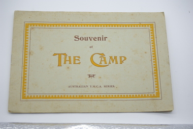
Booklet, Souvenir of The Camp, Australian Y.M.C.A. Series, circ 1900's
Historical photos of camp areaWW1, Camp set-outBooklet, cardboard cover, pages containing Photographs of the camp etc. Booklet containing Photographs of the camp etc. Details are 1. Y.M.C.A. The Camp. 2. The Cross & village Barford. 3. Stonehenge. 4.Main Road, through camp. 5. Main road to Camp. 6. The Camp Headquarters 4 Command. 7. Head Quarters The Camp. 8. H.Q.-Pay office. 8. H.Q, Gardening, The camp. 9. The camp, 9 Command. 10. Garden - Australia map and title. 11. The Smithy Figheldean. "The spreading chestnut tree" -
 Lara RSL Sub Branch
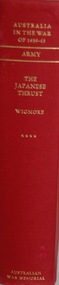
Book, Australia in the War of 1939 - 1945 Series One ARMY Volumn IV THE JAPANESE THRUST, First published 1957
WWII List of events. Part 1 - The Road to War Part 11 - South East Asia Conquered Part III - Prisoners of the Japanese Australia in the War of 1939-1945 - The Japanese Thrust ARMY Author Lionel Wilmore List of events from 1931 - 20th May 1942 Maps, Photographs and IllustrationsAustralian War Memorialww11, japanese, new guinea, 1939-1942, malaya, singapore, prisoners of war, java, timor, burma thai railway -
 Federation University Historical Collection
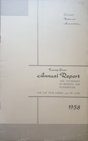
Booklet - Annual Report, Greater Ballarat Association Annual Report 1952-1974, 1952-1974
... dam camera clubs sunraysia way map centre of road parking ...The first presedent of the Greater Ballarat Association in 1938 was Robert J. Cooke. Eighteen annual reports of the Greater Ballarat Association. Each one discussed the work of the association and lists the subscribers. greater ballarat association, annual report, edgar bartrop, g.b. richmond, a.w. nicholson, g.e. deeble, r.g> caddell, l.j. fraser, t.u. haymes, a.w. lynch, keith rash, tourist bureau, botanical gardens telepone booth, pryor park tree planting, ballarat zoological gardens, centenary window dressing competition, soldier settlement, proposal for university for ballarat, caravan park, ballarat common, ballarat common development, t.t. hollway, housing commission, wendouree housing commission, industrial development, s.s. ballarat, begomia festiva, r.g. caddell, w.gordon smith, f.h. menzies, olympic rowing, royal tour decorations, begonia float, widening of railway bridge, j. chatham, l.g. chester, s.v. playsted, n. ellis, langi kal kal, langi kal kal training centre, migrants to victoria, flood lighting of the arch of victory, olympics holidays, ballarat's projected olympic pool, ballarat fish hatcheries, olympic hostel, town planning, murray byrne, titles for residence areas, service club signs, railway level crossing, traffic, ploughing competition, w. fraser, young australia league, removal of raaf from ballarat, renumbering of streets, renumbering of streets to the block system, miners' racecourse reserve, historical museum, ballarat historical society, c.m. canty, mavis canty, university status, ballarat university college, j.w. murray, p.r. gray, b.c. mcorist, n.c. ellis, w.h. heinz, save the lake campaign, lake wendouree, weed, home host scheme, b. walker, develop victoria council, eureka development, victorian decentralization league, r.h. ramsay, allan c. pittard, w. gordon smith, c.h. davis, b.c. hedgcock, les kennedy, p.j. rice, a.f. waddington, john p. cook, historic markers, maze, traffic lights, bungal dam, camera clubs, sunraysia way, map, centre of road parking, paddle steamer, wendouree apex, local government women's association, may nelson, wes sobey, melton foo, l.l. zilles, dulcie sullivan, m. barnes, lou zilles, john wesley sobey, e.r. ingles, herb warren, kryal castle -
 Bendigo Military Museum
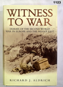
Book, Witness to War. Diaries of the Second World War in Europe and the Middle East, 2004
Witness to War - a retelling of the war experience through the private diaries kept by people from all walks of life and from many countries. Hard cover, black colour buckram, gold print on spine. Dust cover gold and black print on front, back and spine, background sepia colour photograph of military scene. Black and white photograph of military personnel and people. End papers - illustrated with diary pages. 720 pages cut plain. Illustrated black and white photographs and maps.On first front title page - hard written black ink "Len Burke" "Donated by Len Burke family" Owners stamp black ink "Len Burke"/ 11/290 St Aidens Road, Bendigo, Vic. 3550 documents-diaries, military history -
 Bendigo Military Museum
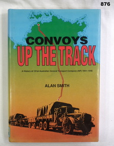
Book, Alan Smith, Convoys Up the Track, 1991
Book, hard cover with dust cover, 300 pages. Dust cover shows a simple map of Northern Territory with a red road from Alice Springs to Darwin. Print is black & red ink. Image at bottom shows 2 parked trucks with drivers. Illustrated with photos, maps & charts.Donated by Bgo Y's Men's Club On fly leaf: To ??? best wishes Alan Smithbooks, military, history -
 Bendigo Military Museum
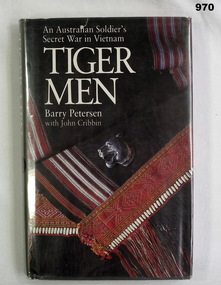
Book, Tiger Men. An Australian Soldier's Secret War in Vietnam, 1988
Hard cover, dark grey background, white print on spine. Dust cover with plastic covering, dark grey colour background, front illustrated tiger head badge, coloured cloth, back illustrated medal set in colour. 245 pages cut plain, illustrated with black and white photographs, maps Front fly leaf - handwritten blue ink - "Francis W Dean BEM:. First title page - owners stamps in black ink "Frances W Dean/"Coval"/ 20 Strickland Road, Bendigo, 3550.books-military-history, vietnam -
 Bendigo Military Museum
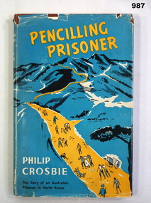
Book, Penciling Prisoner, 1955
Hard cover book with dust cover. Dust cover - blue background, Image of snow covered dark hills. Orange road in centre. Writing in yellow and black ink. Book - brown buckram. Pages - 195. Illustrated - black and white photos and maps. books-military-history, books-biography-pows -
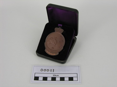 Frankston RSL Sub Branch
Medallion, ANZAC, Government issue, 50th Anniversary of Gallipoli Medallion
Circular bronze medallion surmounted by the Queen's crown. Obverse depicts Simpson and his donkey assisting a wounded man, a laurel wreath, the date '1915' and the word 'ANZAC'. Reverse depicts a map of Australia and New Zealand with the Southern Cross superimposed, fern fronds and the engraved name of the recipient 'A. PEARSON'. This medallion is in its original presentation case. The Anzac Medallion was issued by the Australian government in 1967 to commemorate the 1965 50th anniversary of the Gallipoli landings. The medallion was issued to surviving veterans of the campaign or their next of kin. Refer to AWM item for further information < http://www.awm.gov.au/collection/RELAWM16790.001/ >The name of the recipient, A. Pearson, is engraved on the reverse of this medallion. -
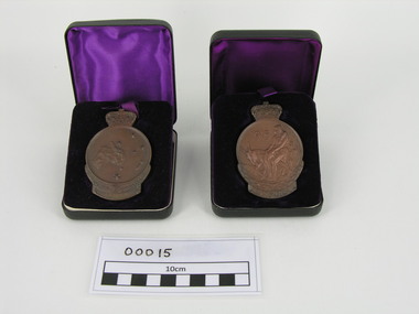 Frankston RSL Sub Branch
Medallion, ANZAC, Government issue, 50th Anniversary of Gallipoli Medallion
Circular bronze medallion surmounted by the Queen's crown. Obverse depicts Simpson and his donkey assisting a wounded man, a laurel wreath, the date '1915' and the word 'ANZAC'. Reverse depicts a map of Australia and New Zealand with the Southern Cross superimposed, fern fronds and the engraved name of the recipient 'G. R. GRIFFITH'. This medallion is in its original presentation case. The Anzac Medallion was issued by the Australian government in 1967 to commemorate the 1965 50th anniversary of the Gallipoli landings. The medallion was issued to surviving veterans of the campaign or their next of kin. Refer to AWM item for further information < http://www.awm.gov.au/collection/RELAWM16790.001/ >The recipients name, G.R. Griffith, is engraved on the reverse of the medallion.ww1, gallipoli, medallion, g r, griffith -
Frankston RSL Sub Branch
Magnifier, Map Reading
A small pocket size folding magnifier used for enlarging detail when reading maps or examining aerial photographs complete with a leather storage pouch. Manufactured of brass by Casartelli of Manchester, England. When unfolded this forms a "U" shape with the glass lens positioned conveniently for map viewing and the base can be used to measure scaled distances.This item is stamped "CASARTELLI, MANCHESTER" and has 1/4, 1/2 and 1 inch markings. -
Frankston RSL Sub Branch
Rule, Scale, E. ESDAILE & SONS, 1942
A scale rule used by artillery units to measure distance between map co-ordinates on the 1 to 25,000 scale military map series. The rule is accurately machined from flat stainless steel strip and is stamped with Imperial measurements (thousands of yards) and metric measurements (thousands of metres).The rule is stamped with the following: "SCALE, ARTY, No 2, MKI, E.ESDAILE & SONS, D^D, 1942"artillery, rule, scale, imperial, metric, distance, world war 2, ww2, -
 Frankston RSL Sub Branch
Map Case
Standard Australian Army webbing map case with shoulder strap. This map case is complete with a folded Australian Survey map of Puckapunyal, Victoria produced in 1988. Inscription BHG Ltd 1945 -
Frankston RSL Sub Branch
Pocketbook, Souvenir, Taschenbuch Groß-Deutschland, Geschichtstafel, Deutschlands Wehrmacht, Weltatlas, 31 August, 1941
provenance unknownSmall, soft cover, pocketbook presumably souvenired from a German soldier during the latter stages of World War 2. The pocketbook is of the type originally issued by the German military and was printed in August 1941, edited by Georg Westermann, Braunschweig. The book has a red coloured cover with black printing and contains 48 pages. Pages are printed in black, the maps are printed in colour. The pocketbook is in good condition, some pages have tears and the cover is scuffed. The pocket book title translates as "Paperback Greater Germany, History Chart, Germany's Wehrmacht, World Atlas" and is a collection of information about the German Reich, German military units and insignia and world maps, 1942 calendar, etc. The original owner has made markings on some maps and has made notes.The front cover is printed in black ink with the following "Taschenbuch Groß-Deutschland, Geschichtstafel, Deutschlands Wehrmacht, Weltatlas" -
Frankston RSL Sub Branch
Map, SECRET LANDING GROUNDS AUSTRALIA
Large map of aircraft landing grounds located in Australia and some nearby Islands. This map shows landing grounds in use during the latter years of World War 2. The map is in Mercator Projection to the Equatorial Scale 1:4,000,000. The scale is statute miles. Each landing ground location is shown by a symbol indicating category and name. The legend explains the landing ground categories: RAAF Main Landing Grounds, RAAF Emergency Landing Grounds, Seaplane Anchorages, Civil Main Landing Grounds, Civil Emergency Landing Grounds and Cancelled Landing Grounds. The map was revised 4th September, 1945. The map is printed on paper which is attached to a linen backing, The map is quite faded and in a fragile condition. -
 Frankston RSL Sub Branch
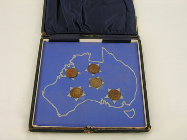
Set, Coin
Square hinged box inscribed on lid 'Anzac Commemoration 1926'. The box is covered with a thin, black leather-like material. The box is lined with cloth. The lower section of the box is lined with a mid-blue cloth which is imprinted, in silver, with the map of Australia in which five English farthings have been set. The coins are in the formation of the Southern Cross with a silver star shape around each farthing. The underside of the box lid has dark blue gathered satin lining. The coins are in uncirculated condition and are loose. The box is damaged.The box is inscibed in gold lettering with the following: "Anzac Commemoration 1926" -
 Frankston RSL Sub Branch
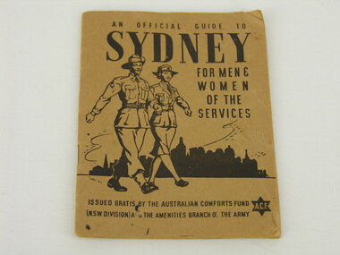
Handbook, An Official Guide to Sydney
Pocketbook produced by the Australian Comforts Fund as a guide to Sydney for service women and men stationed or visiting there. Contains usefull information, contact details for support organisations, public transport information and a map. The book has 32 pages and has a buff coloured paper cover. The booklet cover has the following printed in black ink: "An Official Guide to Sydney for Men & Women of the Services" "Issued by the Australian Comforts Fund (NSW Division) and the Amenities Branch of the Army" -
 Wycheproof & District Historical Society Inc.
Bunguluke Map, Bunguluke District In 1923, 27.2.1923
By 1881 Bunguluke was a small settlement as recorded, December 5, in the Charlton "Mercury". It reports that in that year Draper's Store, Hotel and Post Office and residence at Bunguluke North was totally destroyed by fire. For years now there has been little sign of community life with houses few and far between and acreages have gone into larger holdings. The map references land blocks and owners for that era.This important map shows the local land ownership and local features that existed in 1923. This is a photocopied black and white map of Bunguluke in the County of Kara Kara, Number L5149. Marked - Photo Lithographed by W.J. Butson 27.2.1923. The details include numbers of allotments, property owners, roads, rivers. The boundaries marked are the Parish of Jeruk, Parish of Wycheproof, Parish of Cooroopajerrup. Wycheproof township location is shown with the Scale of Chains. Bunguluke maps for other years are also in the collection.map, bunguluke, jeruk, wycheproof, cooroopajerrup -
 Flagstaff Hill Maritime Museum and Village
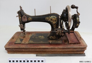
Domestic object - Sewing Machine, 1890s to 1911
This machine was made in Baden, Germany, for the Ward Brothers of Melbourne, who imported machines from various manufacturers and had them branded with their Ward Brothers decals. This machine is most likely dated before 1911, when the Ward Brothers became two separate businesses, as one of the decals appears to have been deliberately removed. The case is made in an attractive design and the machine itself has decorations that are pleasant to the eye. Even the metal cover of the folding handle has a swirling design on it. The machine has the added bonus of a ruler along the front base. Many sewing machine manufacturers in Germany produced their machines specifically for export. A company could mass-produce its machines and give the same product several different brand names, according to their overseas buyers. There was a huge market for domestic machines as it enabled tailored clothing to be made in households at a fraction of the retail prices. Ward Brothers began in Australia in the late 1890s and early sewing machines sold by them had the three brothers on their decals. In 1911 the brothers divided into two separate firms, one operating on his own, the other two remaining together, and all still operating in Melbourne and at first still using the name Ward Brothers.This sewing machine is one of two hand-operated Ward Brothers machines in our collection that were made in Baden, Germany, and the only one that has had the three Ward Brothers on its decal, and that has front and rear slide plates. This machine represents the early domestic market for sewing machines, making it possible for the everyday homemaker to produce fashionable garments and linen ware that was affordable. The owner of this machine could work at more than one location as it was portable and did not require a large space to set up. The machine is associated with the well-known Ward Brothers of Melbourne, who sold imported sewing machines that were branded with their own name. Sewing machine, hand operated, in wooden case. The machine is painted black with gold decals, and front and rear slide plates. The wooden base of the machine has an inlaid ruler. The case has curved sides and shaped ends, decorative woodwork on corners, an inlaid diamond pattern on top, and a folding metal handle. Accessories are included. The decals include doves, inscriptions and swirls, and there is a map of Australia with two portraits of men. The machine was made in Baden, Germany, for Ward Brothers, Melbourne. Images: Map of Australia with States marked, and with portraits of two men. [A portrait-sized area on the left of the men has had the image removed.] Text in printed script: "Specially / Made in Baden" "WARD BROTHERS / MELBOURNE" " with a Logo is a map of Australia,flagstaff hill, warrnambool, great ocean road, sewing machine, hand operated, pre-1911, domestic sewing, homemade clothing, fashion, ward brothers, made in germany, baden, front and rear slide plates, crank handle, hand crank sewing machine -
 Flagstaff Hill Maritime Museum and Village
Document - Map, Department of Lands & Survey, Victoria / Panmure, 1942
This Emergency Edition of the map of Panmure, Victoria, is part of the W.R. Angus Collection. It was printed in 1942 during World War II. It is one of two maps donated to Flagstaff Hill Maritime Village by the family of Doctor William Roy Angus, who served as Surgeon Captain in the Australian Defence Department. The map was compiled for the Dept. of Army by the Dept. of Lands and Survey in Melbourne, prepared by the Australian Section of the Imperial General Staff, which was a British Government body created in 1907 to co-ordinate the defence of Britain and its Empire. It was printed by A.H.Q. Cartographic Company, Survey Corps, which was formed in 1941. The Corp changed its name to L.H.Q. Cartographic Company of Bendigo. In 1947 the name reverted back to the A.H.Q. Cartographic Company until 1955 when it became the A.H.Q. Survey Regiment. The W.R. Angus Collection includes historical medical equipment, surgical instruments and material once belonging to Dr Edward Ryan and Dr Thomas Francis Ryan, (both of Nhill, Victoria) as well as Dr Angus’ own belongings. The Collection’s history spans the medical practices of the two Doctors Ryan, from 1885-1926 plus that of Dr Angus who began practice in 1924. Dr. Angus served with the Australian Department of Defence as a Surgeon Captain during the Second World Was from 1942 to 1945. He served in Ballarat, Victoria, and in Bonegilla, N.S.W. until he suffering from a heart attack just before the war ended. ABOUT THE “W.R.ANGUS COLLECTION” - Doctor William Roy Angus M.B., B.S., Adel., 1923, F.R.C.S. Edin.,1928, was generally known as Dr Roy Angus. His working life included a position as a doctor with the Flying Doctor Service in Australia’s rural and remote areas. After many varied experiences Dr Angus and his family moved to Warrnambool in 1939 where he purchased “Birchwood,” the 1852 home and medical practice of Dr John Hunter Henderson. He was appointed on a part-time basis as Port Medical Officer in Warrnambool and held this position until the 1940’s when the government no longer required the service of a Port Medical Officer. Dr Angus was a surgeon at the Warrnambool Base Hospital 1939-1942. After further studies he commenced practice as an ophthalmologist in Warrnambool, pioneering in artificial eye improvements. He was Honorary Consultant Ophthalmologist to Warrnambool Base Hospital for 31 years and made monthly visits to Portland to perform eye surgery. Dr Angus and his wife Gladys were very involved in Warrnambool’s community with a strong interest in civic affairs. They were both involved in the creation of Flagstaff Hill Maritime Village, including the layout of the gardens. After his death on 28th March 1970 his family requested his practitioner’s plate, medical instruments and some personal belongings be displayed in the Port Medical Office surgery at Flagstaff Hill Maritime Village, and be called the “W. R. Angus Collection”. This Emergency Edition of the Map of Panmure is significant as an example of the documents prepared for the defence of Australia in World War 2. The Map is also significant for its connection between the Australian Army and the involvement of Dr WR Angus as a Surgeon in the Medical Services during World War II. The W.R. Angus Collection is significant for still being located at the site it is connected with, Doctor Angus being the last Port Medical Officer in Warrnambool. The collection of medical instruments and other equipment is culturally significant, being an historical example of medicine, administration, household equipment and clothing from late 19th to mid-20th century. Dr Angus assisted Dr Tom Ryan, a pioneer in the use of X-rays and in ocular surgery. The collection includes Dr Angus’s Army objects and is significant as an example of items issued to Doctors and Surgeons in the Medical Services of the Australian Army in World War IIMilitary map of Panmure, Victoria, Australia; part of the W.R. Angus Collection. Rectangular coloured map on cream paper for the Australian Army. Details include sea, waterways and land, contour lines, grid lines, names of districts, towns and roads, bridges, swamps, rail lines, cuttings, tracks, buildings (including blacksmiths), pumps, lighthouses, telegraph, telephones and electric transmission lines, and fire stations. The map has margin notes that include distances in miles to nearby towns. The map was compiled for the Dept. of Army by the Dept. of Lands and Survey in Melbourne, prepared by the Australian Section, Imperial General Staff and printed by A.H.Q. Cartographic Company, Melbourne in 1942. Crown Copyright Reserved. Inscriptions in red print state that it is and Emergency Edition and an Official document. An oval purple stamp includes the price.Printed in black; 'Victoria / Panmure", "No. 930 / Zone 6" Printed in red; “EMERGENCY EDITION”, “THIS MAP IS AN OFFICIAL DOCUMENT. IF FOUND, IT MUST BE HANDED / IN TO THE NEAREST MILITARY HEADQUARTERS OR POLICE STATION” Stamped: within concentric ovals (“- - - FOR SALE / PRICE 2/- / - - - - - OF THE ARMY”)flagstaff hill, warrnambool, flagstaff hill maritime museum, maritime museum, shipwreck coast, flagstaff hill maritime village, great ocean road, dr w r angus, dr ryan, warrnambool base hospital, flying doctor, surgeon captain, australian department of defence, royal australian army, world war 2, map panmure 1942, roy angus, port medical officer, nhill base hospital, military map, emergency map, military service australian army, department of army, department of lands and survey, a.h.q. cartographic company melbourne, panmure 1942, australian section, imperial general staff -
 Flagstaff Hill Maritime Museum and Village
Document - Map, Department of Lands & Survey, Victoria / Port Campbell, 1942
This Emergency Edition of the map of Port Campbell, Victoria, is part of the W.R. Angus Collection. It was printed in 1942 during World War II. It is one of two maps donated to Flagstaff Hill Maritime Village by the family of Doctor William Roy Angus, who served as Surgeon Captain in the Australian Defence Department. The map was compiled for the Dept. of Army by the Dept. of Lands and Survey in Melbourne, prepared by the Australian Section of the Imperial General Staff, which was a British Government body created in 1907 to co-ordinate the defence of Britain and its Empire. It was printed by A.H.Q. Cartographic Company, Survey Corps, which was formed in 1941. The Corp changed its name to L.H.Q. Cartographic Company of Bendigo. In 1947 the name reverted back to the A.H.Q. Cartographic Company until 1955 when it became the A.H.Q. Survey Regiment. The W.R. Angus Collection includes historical medical equipment, surgical instruments and material once belonging to Dr Edward Ryan and Dr Thomas Francis Ryan, (both of Nhill, Victoria) as well as Dr Angus’ own belongings. The Collection’s history spans the medical practices of the two Doctors Ryan, from 1885-1926 plus that of Dr Angus who began practice in 1924. Dr Angus served with the Australian Department of Defence as a Surgeon Captain during the Second World Was from 1942 to 1945. He served in Ballarat, Victoria, and in Bonegilla, N.S.W. until he suffering from a heart attack just before the war ended. ABOUT THE “W.R.ANGUS COLLECTION” - Doctor William Roy Angus M.B., B.S., Adel., 1923, F.R.C.S. Edin.,1928, was generally known as Dr Roy Angus. His working life included a position as a doctor with the Flying Doctor Service in Australia’s rural and remote areas. After many varied experiences Dr Angus and his family moved to Warrnambool in 1939 where he purchased “Birchwood,” the 1852 home and medical practice of Dr John Hunter Henderson. He was appointed on a part-time basis as Port Medical Officer in Warrnambool and held this position until the 1940’s when the government no longer required the service of a Port Medical Officer. Dr Angus was a surgeon at the Warrnambool Base Hospital 1939-1942. After further studies he commenced practice as an ophthalmologist in Warrnambool, pioneering in artificial eye improvements. He was Honorary Consultant Ophthalmologist to Warrnambool Base Hospital for 31 years and made monthly visits to Portland to perform eye surgery. Dr Angus and his wife Gladys were very involved in Warrnambool’s community with a strong interest in civic affairs. They were both involved in the creation of Flagstaff Hill Maritime Village, including the layout of the gardens. After his death on 28th March 1970 his family requested his practitioner’s plate, medical instruments and some personal belongings be displayed in the Port Medical Office surgery at Flagstaff Hill Maritime Village, and be called the “W. R. Angus Collection”. This Emergency Edition of the Map of Port Campbell is significant as an example of the documents prepared for the defence of Australia in World War 2. The Map is also significant for its connection between the Australian Army and the involvement of Dr WR Angus as a Surgeon in the Medical Services during World War II. The W.R. Angus Collection is significant for still being located at the site it is connected with, Doctor Angus being the last Port Medical Officer in Warrnambool. The collection of medical instruments and other equipment is culturally significant, being an historical example of medicine, administration, household equipment and clothing from late 19th to mid-20th century. Dr Angus assisted Dr Tom Ryan, a pioneer in the use of X-rays and in ocular surgery. The collection includes Dr Angus’s Army objects and is significant as an example of items issued to Doctors and Surgeons in the Medical Services of the Australian Army in World War IIMilitary map of Port Campbell, Victoria, Australia; part of the W.R. Angus Collection. Rectangular coloured map on cream paper for the Australian Army. Details include sea, waterways and land, contour lines, grid lines, names of districts, towns and roads, bridges, swamps, rail lines, cuttings, tracks, buildings (including blacksmiths), pumps, lighthouses, telegraph, telephones and electric transmission lines, and fire stations. The map has margin notes that include distances in miles to nearby towns. The map was compiled for the Dept. of Army by the Dept. of Lands and Survey in Melbourne, prepared by the Australian Section, Imperial General Staff and printed by A.H.Q. Cartographic Company, Melbourne in 1942. Crown Copyright Reserved. Inscriptions in red print state that it is and Emergency Edition and an Official document. An oval purple stamp includes the price.Printed in black; 'Victoria / Port Campbell", "No. 932 / Zone 6" Printed in red; “EMERGENCY EDITION”, “THIS MAP IS AN OFFICIAL DOCUMENT. IF FOUND, IT MUST BE HANDED / IN TO THE NEAREST MILITARY HEADQUARTERS OR POLICE STATION” Stamped: within concentric ovals (“- - - FOR SALE / PRICE 2/- / - - - - - OF THE ARMY”)flagstaff hill, warrnambool, flagstaff hill maritime museum, maritime museum, shipwreck coast, flagstaff hill maritime village, great ocean road, dr w r angus, dr ryan, warrnambool base hospital, nhill base hospital, flying doctor, surgeon captain, map port campbell 1942, roy angus, port medical officer, military map, emergency map, australian department of defence, royal australian army, military service australian army, department of army, department of lands and survey, world war 2, a.h.q. cartographic company melbourne, australian section, imperial general staff, port campbell 1942 -
 Flagstaff Hill Maritime Museum and Village
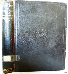
Book, The Outline of History Vol 1
This item is from the ‘Pattison Collection’, a collection of books and records that was originally owned by the Warrnambool Mechanics’ Institute, which was founded in Warrnambool in 1853. By 1886 the Warrnambool Mechanics’ Institute (WMI) had grown to have a Library, Museum and Fine Arts Gallery, with a collection of “… choice productions of art, and valuable specimens in almost every branch and many wonderful national curiosities are now to be seen there, including historic relics of the town and district.” It later included a School of Design. Although it was very well patronised, the lack of financial support led the WMI in 1911 to ask the City Council to take it over. In 1935 Ralph Pattison was appointed as City Librarian to establish and organise the Warrnambool Library as it was then called. When the WMI building was pulled down in 1963 a new civic building was erected on the site and the new Warrnambool Library, on behalf of the City Council, took over all the holdings of the WMI. At this time some of the items were separated and identified as the ‘Pattison Collection’, named after Ralph Pattison. Eventually the components of the WMI were distributed from the Warrnambool Library to various places, including the Art Gallery, Historical Society and Flagstaff Hill. Later some were even distributed to other regional branches of Corangamite Regional Library and passed to and fro. It is difficult now to trace just where all of the items have ended up. The books at Flagstaff Hill Maritime Village generally display stamps and markings from Pattison as well as a variety of other institutions including the Mechanics’ Institute itself. RALPH ERIC PATTISON Ralph Eric Pattison was born in Rockhampton, Queensland, in 1891. He married Maude Swan from Warrnambool in 1920 and they set up home in Warrnambool. In 1935 Pattison accepted a position as City Librarian for the Warrnambool City Council. His huge challenge was to make a functional library within two rooms of the Mechanics’ Institute. He tirelessly cleaned, cleared and sorted a disarrayed collection of old books, jars of preserved specimens and other items reserved for exhibition in the city’s museum. He developed and updated the library with a wide variety of books for all tastes, including reference books for students; a difficult task to fulfil during the years following the Depression. He converted all of the lower area of the building into a library, reference room and reading room for members and the public. The books were sorted and stored using a cataloguing and card index system that he had developed himself. He also prepared the upper floor of the building and established the Art Gallery and later the Museum, a place to exhibit the many old relics that had been stored for years for this purpose. One of the treasures he found was a beautiful ancient clock, which he repaired, restored and enjoyed using in his office during the years of his service there. Ralph Pattison was described as “a meticulous gentleman whose punctuality, floorless courtesy and distinctive neat dress were hallmarks of his character, and ‘his’ clock controlled his daily routine, and his opening and closing of the library’s large heavy doors to the minute.” Pattison took leave during 1942 to 1945 to serve in the Royal Australian Navy, Volunteer Reserve as Lieutenant. A few years later he converted one of the Museum’s rooms into a Children’s Library, stocking it with suitable books for the younger generation. This was an instant success. In the 1950’s he had the honour of being appointed to the Victorian Library Board and received more inspiration from the monthly conferences in Melbourne. He was sadly retired in 1959 after over 23 years of service, due to the fact that he had gone over the working age of council officers. However he continued to take a very keen interest in the continual development of the Library until his death in 1969. The Pattison Collection, along with other items at Flagstaff Hill Maritime Village, was originally part of the Warrnambool Mechanics' Institute’s collection. The Warrnambool Mechanics’ Institute Collection is primarily significant in its totality, rather than for the individual objects it contains. Its contents are highly representative of the development of Mechanics' Institute libraries across Australia, particularly Victoria. A diversity of publications and themes has been amassed, and these provide clues to our understanding of the nature of and changes in the reading habits of Victorians from the 1850s to the middle of the 20th century. The collection also highlights the Warrnambool community’s commitment to the Mechanics’ Institute, reading, literacy and learning in the regions, and proves that access to knowledge was not impeded by distance. These items help to provide a more complete picture of our community’s ideals and aspirations. The Warrnambool Mechanics Institute book collection has historical and social significance for its strong association with the Mechanics Institute movement and the important role it played in the intellectual, cultural and social development of people throughout the latter part of the nineteenth century and the early twentieth century. The collection of books is a rare example of an early lending library and its significance is enhanced by the survival of an original collection of many volumes. The Warrnambool Mechanics' Institute’s publication collection is of both local and state significance. The Outline of History Vol 1 Being a Plain History of Life and Mankind with maps & Plans by J. F. Horrabin Author: H G Wells Publisher: Waverley Book Co Ltd Date: 1925Label on spine cover with typed text PAT F 909 WEL Pastedown front endpaper has sticker from Warrnambool Public Library covered by a sticker from Corangamite Regional Library Service Front loose endpaper has a stamp from Corangamite Regional Library Service Fly paper has a stamp from Corangamite Regional Library Servicewarrnambool, shipwrecked-coast, flagstaff-hill, flagstaff-hill-maritime-museum, maritime-museum, shipwreck-coast, flagstaff-hill-maritime-village, shipwrecked-artefact, book, pattison collection, warrnambool library, warrnambool mechanics’ institute, ralph eric pattison, corangamite regional library service, warrnambool city librarian, mechanics’ institute library, victorian library board, warrnambool books and records, warrnambool children’s library, great ocean road, h g wells, the outline of history vol 1 -
 Flagstaff Hill Maritime Museum and Village
Book - Reference Book, Mr Salmon (Thomas Salmon) et al, Modern History: or, the Present State of All Nations. Vol III, 1746
The author was Mr. Salmon (Thomas Salmon), (1679-1788). The fly page of the book has the following writing in red and black print: "Describing their Respective Situations, Persons, Habits, and Buildings; Manners, Laws and Customs, Religion and Policy; Arts and Sciences, Trades, Manufacturers and Husbandry; Plants, Animals and Minerals. Illustrated with Cuts and Maps, accurately drawn according to the Geographical Part of this Work by Herman Moll. Third Edition with considerable Additions and Improvements, interspersed in the Body of the Work: Also the History and Revolutions of each Country, brought down to the present Time. " Thomas Longman founded his publishing firm in 1724 in London by the name Longman. In August of that year, he bought the two shops and goods of William Taylor and set up his publishing house there at 39 Paternoster Row. The shops were called Black Swan and Ship, and it is said that the 'ship' sign was the inspiration for Longman's Logo. After many changes of name and management, including the name T Longman and T Shewell in 1746. The firm was incorporated in 1926 as Longmans, Green & Co. Pty Ltd. The firm was acquired by Pearson in 1968 and was known as Pearson Longman or Pearson PLC. The book is part of Flagstaff Hill's Pattison Collection, a large group of books and records, some of which are rare and valuable. The collection was originally owned by the Warrnambool Mechanics' Institute, which was founded in 1853 and is named after Warrnambool's Public Librarian, Ralph Pattison.The book is significant for its age – it is one of the oldest books in Flagstaff Hill’s collection, published in 1746. The book is a record of Modern History at that time and allows studying and comparing those times with today. The book is important for its connection with the London publisher T Longman and T Sewell, who only operated under this name between 1745 and 1747. The firm has been established for over two centuries and is renowned for publishing encyclopedias, dictionaries, books on English grammar, textbooks, poetry, reference books, novels, magazines and more. The book has additional importance for its connection to the Pattison Collection, which, along with other items at Flagstaff Hill Maritime Village, was originally part of the Warrnambool Mechanics' Institutes’ Collection. The Warrnambool Mechanics’ Institute book collection has historical and social significance for its strong association with the Mechanics Institute movement and its important role in people's intellectual, cultural and social development throughout the latter part of the nineteenth century and the early twentieth century. The collection of books is a rare example of an early lending library and its significance is enhanced by the survival of an original collection of many volumes. The Warrnambool Mechanics' Institute’s publication collection is of both local and state significance.Modern History: or, the Present State of All Nations Vol III Author: Mr. Salmon (Thomas Salmon) Illustrator: Herman Moll Publisher: T Longman and T Shewell in Paternoster Row, London Date: 1746 (MDCCXLVI), 3rd Edition Further Information: In Three Volumes, Vol. III The large hardcovered book has reinforcing on the spine and corners. The cover is very well worn and has remnants of a coloured design. The fly page is printed in red and black ink and has a long description of the contents. Inside the cover is printed a Coat of Arms. There is a stocker on the inside cover, The book is part of the Pattison Collection.Label on the spine "RH F910 SAL" Sticker on the pastedown front endpaper "Corangamite Regional Library Service" Printed on pastedown front endpaper "Coat of arms, crown above a shield with an inverted V with three stars on it" Sticker on front loose endpaper "Coat of arms, with "F C G Ritso"flagstaff hill, flagstaff hill maritime museum and village, warrnambool, maritime museum, maritime village, great ocean road, shipwreck coast, pattison collection, ralph eric pattison, warrnambool mechanics’ institute, mechanics’ institute library, warrnambool library, free library, corangamite regional library service, mr salmon, thomas salmon, 18th century, 1746, history, geography, social studies, culture, maps, modern history, present state of all nations vol iii, herman moll, t longman and t shewell, social history -
 Flagstaff Hill Maritime Museum and Village
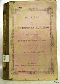
Book, Journal of Landsboroughs Expedition
WARRNAMBOOL MECHANICS’ INSTITUTE Warrnambool's Mechanics' Institute (or Institution as it was sometimes called) was one of the earliest in Victoria. On 17th October 1853 a meeting was held where it was resolved to request the Lieutenant Governor of the Colony to grant land for the erection of a Mechanics' Institutes building. A committee was formed at the meeting and Richard Osburne chaired the first meeting of this committee. The land on the North West corner of Banyan and Merri Streets was granted but there were no funds to erect the building. The Formal Rights of the Warrnambool Mechanics' Institute's encompassed its aims and these were officially adopted in1859; "This Institution has for its object the diffusion of literary, scientific, and other useful knowledge amongst its members, excluding all controversial subjects, religious or political. These objects are sought to be obtained by means of a circulating library, a reading room, the establishment of classes, debates, and the occasional delivery of lectures on natural and experimental philosophy, mechanics, astronomy, chemistry, natural history, literature, and the useful and ornamental arts, particularly those which have a more immediate reference to the colony." The Warrnambool Mechanics' Institute opened its first reading room in November1884 in the National School building at the corner of Banyan and Timor Streets. The Institute was funded by member subscription, payable on a quarterly, half yearly or yearly basis. Samuel Hannaford, the Manager of the Warrnambool Bank of Australasia, was the first Honorary Secretary of the Mechanics' Institutes, and an early President and Vice-President. He also gave several of the early lectures in the Reading Room. Another early Secretary, Librarian and lecturer was Marmaduke Fisher, the teacher at the National School. Lecture topics included The Poets and Poetry of Ireland', 'The Birth and Development of the Earth', 'The Vertebrae - with Remarks on the pleasures resulting from the study of Natural History' and 'Architecture'. In 1856 the Reading Room was moved to James Hider's shop in Timor Street, and by 1864 it was located in the bookshop of Davies and Read. In the 1860's the Mechanics' Institute struggled as membership waned but in 1866, after a series of fund raising efforts, the committee was able to purchase land in Liebig Street, on a site then called Market Square, between the weighbridge and the fire station. A Mechanics' Institute building was opened at this site in August 1871. The following year four more rooms were added to the main Reading Room and in 1873 the Artisan School of Design was incorporated into the Institute. The same year Joseph Archibald established a Museum; however it deteriorated when he was transferred to Bendigo in 1877. In 1880, with Archibald's return to Warrnambool, the Museum was re-established, and in 1885 a new building was built at the back of the Institute to accommodate the re-created School of Design, the Art Gallery and the Museum. In 1887 the Museum section was moved to the former court house in Timor Street (for some time the walls of the building formed part of the TAFE cafeteria but all is now demolished)). In 1911 the Museum was transferred back to the original building and the management of the Mechanics' Institute was handed over to the Warrnambool City Council. The Museum and Art Gallery became one and housed many fine works of art, and the Library continued to grow. The building was well patronised, with records showing that at the beginning of the 20th century there were between 500 and 800 visitors. During World War One the monthly figures were in the thousands, with 3,400 people visiting in January 1915. The Museum was a much loved Institution in Warrnambool until the contents of the Museum and Art Gallery were removed to make room for the Warrnambool City Council Engineers' Department. The contents were stored but many of the items were scattered or lost. When the original building was demolished the site became occupied by the Civic Centre, which included the new City Library. (The library was temporarily located in the old Palais building in Koroit Street.) In the process of reorganisation the Collection was distributed amongst the community groups: -The new City Library took some of the historic books and some important documents, historic photographs and newspapers. -The Art Gallery kept the 19th Century art collection and some of the artefacts from the museum. -The Historic Society has some items -The State Museum has some items -Some items were destroyed -Flagstaff Hill Maritime Village has old newspapers, Government Gazettes, most of the Mechanics' Institute Library, ledgers and documents connected to the Mechanics' Institute Library, some framed and unframed art works and some photographs. The Warrnambool Mechanics' Institute Library book collection is deemed to be of great importance because it is one of the few collections in an almost intact state, and many of the books are now very rare and of great value. Journal of Landsboroughs Expedition From Carpentaria in search of Burke and Wills (maps missing) Publisher: Wilson & Mackinnon Date: 1862Label on spine cover with typed text RA 919.4 LAN Pastedown front endpaper has sticker from Warrnambool Mechanics Institute and Free Librarywarrnambool, shipwrecked-coast, flagstaff-hill, flagstaff-hill-maritime-museum, maritime-museum, shipwreck-coast, flagstaff-hill-maritime-village, shipwrecked-artefact, great ocean road, book, warrnambool library, warrnambool mechanics’ institute, mechanics’ institute library, victorian library board, warrnambool books and records, warrnambool children’s library, warrnambool public library, journal of landsboroughs expedition, carpentaria, wilson & mackinnon