Showing 367 items
matching rural life
-
 The Celtic Club
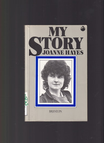
Book, Joanne Hayes, My Story, 1985
Joanne Hayes own account of her life and family background in rural Ireland prior to her humiliation of a public tribunal which wrongly accused her of murder.Ill, p190.non-fictionJoanne Hayes own account of her life and family background in rural Ireland prior to her humiliation of a public tribunal which wrongly accused her of murder.ireland - biography- joanne hayes., ireland - cultural life -
 Wodonga & District Historical Society Inc
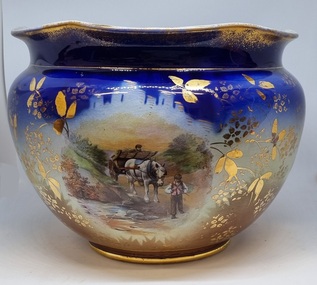
Decorative object - Decorative ceramic bowl
This bowl was used in the home of Mrs. Laura Sommer nee Costa grandmother of one of the life members of Wodonga & District Historical Society who donated this item to our collection. It is representative of decorative household items in the early to mid 20th century.This item is an outstanding example of popular decorative household items from the 19th and early 20th century.A large ceramic decorative bowl featuring rural images. The primary colours of the bowl is a deep blue with gilt edges and markings. It features 2 rural scenes showing men with horses and a cart. The top edge is slightly contoured. There is a maker's mark underneath the bowl.Maker's map on base: A small flower within and larger flower shape with "MADE IN ENGLAND" written around it.decorative bowls, domestic items, ceramics, english ceramics and porcelain -
 Wodonga & District Historical Society Inc
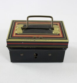
Leisure object - Haeusler Collection Child's Chad Valley Money Tin c. 1930s-1950s, Chad Valley, c. 1930s - 1950s
... Collection that reflects domestic life and childhood in rural... Collection that reflects domestic life and childhood in rural ...The Wodonga Historical Society Haeusler Collection provides invaluable insight into life in late nineteenth and early twentieth century north east Victoria. The collection comprises manuscripts, personal artefacts used by the Haeusler family on their farm in Wodonga, and a set of glass negatives which offer a unique visual snapshot of the domestic and social lives of the Haeusler family and local Wodonga community. The Haeusler family migrated from Prussia (Germany) to South Australia in the 1840s and 1850s, before purchasing 100 acres of Crown Land made available under the Victorian Lands Act 1862 (also known as ‘Duffy’s Land Act’) in 1866 in what is now Wodonga West. The Haeusler family were one of several German families to migrate from South Australia to Wodonga in the 1860s. This child's money box was manufactured by British toy company Chad Valley, owned by the supermarket chain Sanisbury's. It is one of many items in the Wodonga Historical Society's Haeusler Collection that reflects domestic life and childhood in rural Australia in the early to mid twentieth century.This item has well documented provenance and a known owner. It forms part of a significant and representative historical collection which reflects the local history of Wodonga. It contributes to our understanding of domestic and family life in early twentieth century Wodonga, as well as providing interpretative capacity for themes including local history, social history, and the history of childhood. A black, gold and red money tin with a coin slot on a hinged lid. On back of tin on hinge of lid ""CHAD VALLEY"/'ENGLAND/10167"toy, child, children, money, money box -
 Wodonga & District Historical Society Inc
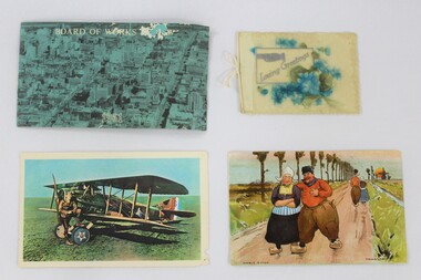
Postcard - Haeusler Collection Postcards and Greeting Card c. Mid-Century
The Wodonga Historical Society Haeusler Collection provides invaluable insight into life in late nineteenth and early twentieth century north east Victoria. The collection comprises manuscripts, personal artefacts used by the Haeusler family on their farm in Wodonga, and a set of glass negatives which offer a unique visual snapshot of the domestic and social lives of the Haeusler family and local Wodonga community. The Haeusler family migrated from Prussia (Germany) to South Australia in the 1840s and 1850s, before purchasing 100 acres of Crown Land made available under the Victorian Lands Act 1862 (also known as ‘Duffy’s Land Act’) in 1866 in what is now Wodonga West. The Haeusler family were one of several German families to migrate from South Australia to Wodonga in the 1860s. This item has well documented provenance and a known owner. It forms part of a significant and representative historical collection which reflects the local history of Wodonga. It contributes to our understanding of domestic and family life in early twentieth century Wodonga, as well as providing interpretative capacity for themes including local history and social history.Three postcards and one greeting card. The postcards depict a photograph of a city with text reading "Board of Works" overlaid; a man posing with an early 1900s airplane; and an illustrated cartoon man and woman walking on a road in a rural area in Europe. The greeting card has text that reads "Loving Greetings" and a raised floral bouquet design made of plastic.haeusler collection, wodonga, postcards, postcard, post, mail, airplane, greeting cards -
 Wodonga & District Historical Society Inc
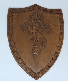
Functional object - RAEME Shield, c1978
RAEME Corps was first established in 1942 when the Ordnance Corps and the Service Corps were combined. The royal ascent was granted in 1948. The Royal Australian Electrical and Mechanical Engineers (RAEME) is a technical corps tasked with the maintenance of the Army's modern hardware and equipment. RAEME personnel are represented in most Army units. The Royal Australian Electrical and Mechanical Engineers corps motto is ‘Arte et Marte’, which is Latin for ‘With Skill and Fighting’. This item, was presented to the Council of the Rural City of Wodonga in 1978. RAEME has a strong connection with the city of Wodonga through its service and training facilities at the Bandiana base on the edge of Wodonga. A shield shaped plaque carved with the emblem of RAEME corps (The Royal Australian Electrical and Mechanical Engineers corps). The edge of the shield is decorated with carved leaves. An engraved metal plate has been attached to acknowledge the presentation of the plaque to the Council of the Rural City of Wodonga. The rearing horse and chain are symbolic of power under control and the lightning flash, of electrical engineering. The rearing horse also forms part of the crest of the Institution of Mechanical Engineers and, together with the lightning flash, is intended to mark the close relationship which exists between the electrical and mechanical engineers in both civil and military life. The globe is indicative of the impact of engineering on the world generally.Attached to rear of shield "Presented to/The Council of the Rural CIty of Wodonga/ by/ The Commanding Officer and Members of/RAEME Training Centre/ 21 October 1978"raeme, australian army -
 Wodonga & District Historical Society Inc
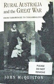
Book - Rural Australia and the Great War - From Tarrawingee to Tangambalanga, John McQuilton, 2001
This publication covers common issues of life in Australia during World War 1, such as recruitment, fundraising, conscription, homecomings and the construction of memorials. However it is unique in that these aspects of war are examined through a focus on rural communities in North Eastern Victoria. The first chapter describes the region and its towns at the outbreak of war, then discusses the fracturing impact of war on different groups within these communities. It paints an interesting social history at a critical time in Australia's development. John Quilton is a native of North Eastern Victoria, having been born in Yackandandah and educated in Tangambalanga and Wodonga. He was a senior member of the Bicentennial History Project at the University of New South Wales, and head of the History and Politics Program at the University of Wollongong.This book consists of 275 pages including photos and a map, as well as an extensive bibliography. The cover depicts a soldier and his family and a country town streetscape on the back.This publication covers common issues of life in Australia during World War 1, such as recruitment, fundraising, conscription, homecomings and the construction of memorials. However it is unique in that these aspects of war are examined through a focus on rural communities in North Eastern Victoria. The first chapter describes the region and its towns at the outbreak of war, then discusses the fracturing impact of war on different groups within these communities. It paints an interesting social history at a critical time in Australia's development. John Quilton is a native of North Eastern Victoria, having been born in Yackandandah and educated in Tangambalanga and Wodonga. He was a senior member of the Bicentennial History Project at the University of New South Wales, and head of the History and Politics Program at the University of Wollongong.world war 1, rural conditions australia 1914, world war 1 social conditions australia, tangambalanga world war 1 -
 Wodonga & District Historical Society Inc
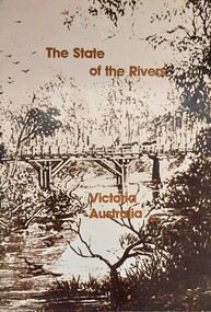
Book - The State of the Rivers, Victoria Australia, Constable, D & Smith, K, 1983
Rivers play an essential part in the life and wealth of our society. They are also the most striking feature of the landscape, contributing much to the beauty of rural and urban surroundings as well as to the recreation, peace and happiness of our people. This report includes historical colour and black and white photos and maps. It aimed to give an accurate account of the condition of the rivers of Victoria. It was produced by the Standing Consultative Committee on River Improvement.A 64 page volume including text, black and white and colour images and maps.Rivers play an essential part in the life and wealth of our society. They are also the most striking feature of the landscape, contributing much to the beauty of rural and urban surroundings as well as to the recreation, peace and happiness of our people. This report includes historical colour and black and white photos and maps. It aimed to give an accurate account of the condition of the rivers of Victoria. It was produced by the Standing Consultative Committee on River Improvement.rivers in victoria, conservation victoria, water supply victoria -
 Wodonga & District Historical Society Inc
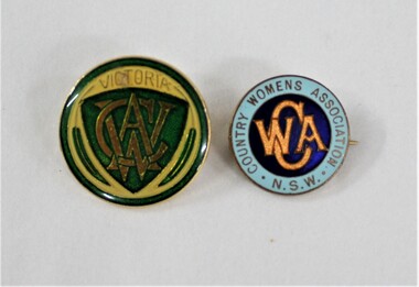
Badge - Hamilton-Smith Collection Country Women's Association
The Hamilton-Smith collection was donated by the children of Grace Mary Hamilton-Smith nee Ellwood (1911-2004) and John Hamilton-Smith (1909-1984) who settled in Wodonga in the 1940s. The Ellwood family had lived in north-east Victoria since the late 1800s. Grace’s mother, Rosina Ellwood nee Smale, was the first teacher at Baranduda in 1888, and a foundation member of the C.W.A. Rosina and her husband Mark retired to Wodonga in 1934. Grace and John married at St. David’s Church, Albury in 1941. John was a grazier, and actively involved in Agricultural Societies. The collection contains significant items which reflect the local history of Wodonga, including handmade needlework, books, photographs, a wedding dress, maps, and material relating to the world wars. This item has well documented provenance and a known owner. It forms part of a significant and representative historical collection which reflects the local history of Wodonga. It contributes to our understanding of social and family life in early twentieth century Wodonga, as well as providing interpretative capacity for themes including local history and social history. Two small round badges. The NSW CWA badge has a light and dark blue design with orange. The Victorian badge has a yellow, green and gold design.On Victorian badge: "VICTORIA/CWA". On NSW Badge: "COUNTRY WOMENS ASSOCIATION N.S.W./CWA".hamilton-smith collection, hamilton-smith, ellwood, charity, volunteer, voluntering, cwa, country women's association, rural, women, women's history, domestic, cooking, food, community -
 Wodonga & District Historical Society Inc
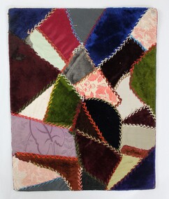
Textile - Hamilton-Smith Collection Victorian-era Crazy Quilt Sampler
The Hamilton-Smith collection was donated by the children of Grace Mary Hamilton-Smith nee Ellwood (1911-2004) and John Hamilton-Smith (1909-1984) who settled in Wodonga in the 1940s. The Ellwood family had lived in north-east Victoria since the late 1800s. Grace’s mother, Rosina Ellwood nee Smale, was the first teacher at Baranduda in 1888, and a foundation member of the C.W.A. Rosina and her husband Mark retired to Wodonga in 1934. Grace and John married at St. David’s Church, Albury in 1941. John was a grazier, and actively involved in Agricultural Societies. The collection contains significant items which reflect the local history of Wodonga, including handmade needlework, books, photographs, a wedding dress, maps, and material relating to the world wars. This quilt sampler was made before 1900 by Rosina Ellwood. Crazy quilts were fashionable in the late Victorian era. The rise of the trend is attributed to the display of Japanese art and ceramics at the 1876 Philadelphia Centennial Exposition (U.S.A.) that featured asymmetrical designs. Inspired, quilters began sewing pieces of fabric of different sizes and textures together into abstract, asymmetrical patterns. The craze spread from America around the world. Embroidery, ribbon and silk embellishments, and hand stitched applique birds and flowers were popular additions. One magazine estimated that a detailed crazy quilt could take over 1,500 hours to complete. Crazy quilts remained in fashion in metropolitan cities until about 1910, though the style endured for longer in rural areas. This item is unique, handmade and has a known owner. It forms part of a significant and representative historical collection which reflects the local history of Wodonga. It contributes to our understanding of domestic and family life in early twentieth century Wodonga, as well as providing interpretative capacity for themes including local history, social history and women’s history.A colourful patchwork quilt sampler using mixed fabric types including velvet, cotton, brocade and satin, backed on cardboard.hamilton-smith collection, hamilton-smith, stiching, needlework, sewing, handmade, domestic, quilt, quilts, crazy quilt, crazy quilts, women's history -
 Wodonga & District Historical Society Inc
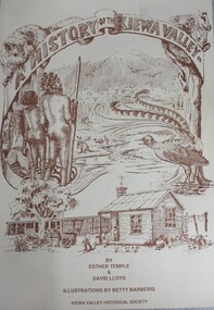
Book - A History of the Kiewa Valley, Esther Temple et al, 1989
This book briefly covers the period from the indigenous tribes who lived in the valley well before English settlers arrived. It documents the transformation of the area from a pristine valley environment to one that has been gradually over 200 years to a more commercial rural/industrial landscaped valley. The book details the first pioneers and their descendants, along with the changes to their environment.This book briefly covers the period from the indigenous tribes who lived in the valley well before English settlers arrived. It documents the transformation of the area from a pristine valley environment to one that has been gradually over 200 years to a more commercial rural/industrial landscaped valley. The book details the first pioneers and their descendants, along with the changes to their environment.kiewa river valley, pioneers victoria, kiewa valley social life and cusstoms -
 City of Kingston
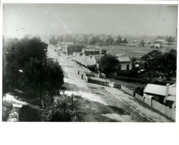
Photograph - Black and white, Percy Fairlam, c. 1910
Black and white image of Cheltenham in the early 20th Century depicts an almost idyllic life. This photo was taken by Percy Fairlam, who climbed a tall pine tree to achieve the aerial view. The tree was a well recognised feature of the Cheltenham skyline but was cut down some time before World War II.Cheltenham was established as a rural market gardening community. The development of the railway was crucial to the ongoing development of the area. Community life sprung up around the railway line which is evident in the proximity of shopping and leisure.Black and white image depicting aerial view down Charman Road, Cheltenham, including the unsealed road, level crossing and shopping centre. What appears to be a cricket pitch is located behind the shops.Handwritten in black ink on a red round sticker adhered to the reverse, and then crossed out: X14 Handwritten in blue ink on reverse: A8 Handwritten in red ink on reverse: 85%cheltenham, railway crossing, roads, housing, shopping strip -
 Bendigo Historical Society Inc.
Document - Dean John Christian MacCullagh (1982 - 1917), 5/09/2023
John Christian MacCullagh (5/6/1832 - 24/9/1917) Born in Ireland Dean MacCullagh came to Victoria in 1863 and was ordained as a minister in 1864 and his first posting was to Lancefield where he served as the first resident minister 1867-1870. Following the death of his young wife he moved to Bendigo in 1870 as the parish minister for St Pauls in Myers Street. At this stage the church was a long way from completion. 1872 made Canon 1877 Bishop's Canon 1883 rural dean 1883 Archdeacon of Sandhurst 1902 Dean of the diocese 1916 retired due to ill health 1917 Died in Melbourne and was buried at Lancefield. A triptych stained glass window at St Pauls stands as a memorial to his service of 47 years.Biography Six-page notes on the life and service of Dean John Christian MacCullagh. Typed pages.biography, dean maccullagh -
 Linton Mechanics Institute and Free Library Collection
Book - Novel, Wallace, Doreen, Billy Potter, 1946
... rural life, a young farm labourer and the vicar's daughter. Book ...Story of English rural life, a young farm labourer and the vicar's daughter.192 p. : brown cover, title and author's name on section of original dust jacket pasted to front. Outline of novel (from original dust jacket) pasted inside front cover. fictionStory of English rural life, a young farm labourer and the vicar's daughter.fiction, doreen wallace -
 Eltham District Historical Society Inc
Photograph - Digital Photograph, Marguerite Marshall, One Tree Hill Mine, Smiths Gully, 8 June 2006
Gold was discovered on One Tree Hill in 1854. The site has been worked intermittently until fairly recent times. Published: Nillumbik Now and Then / Marguerite Marshall 2008; photographs Alan King with Marguerite Marshall.; p53 Though still a working mine, One Tree Hill Mine at Smiths Gully, now stands in a tranquil reserve surrounded by bush and native animals - in contrast to its heyday. In the mid 19th century, when the mine was part of the Caledonia Goldfields, hundreds of men in search of their fortune worked the alluvial gold in the Yarra River, its tributaries and the reefs that made up the goldfields. Miner Stan Bone, assisted by Wilfred Haywood, is the last of the independent gold miners in the area and still uses the quartz crushing battery as miners did when gold was first discovered in the area in 1851.1 Stan, who is the last of six generations of miners in his family, was aged 17 when he began mining on his father Alex’ mine, The Golden Crown in Yarrambat. These days, after blasting the gold-bearing rock in Mystery Reef, one of the four reefs at One Tree Hill, Stan transports it around five kilometres by tip truck to the Black Cameron Mine for crushing. There he uses water from the waterlogged mine, (which still contains gold), as the Happy Valley Creek at One Tree Hill is usually dry.2 The One Tree Hill Mine has been worked for close to a century since it opened around the late 1850s.3 The Swedish Reef was its most productive reef and one of the largest in the area. Around 1859, extractions included 204 ounces (5.8kg) of gold, won from 57 pounds (26kg) of stone.4 Then during World War Two, Stan’s uncle, Bill Wallace, and Alex Bone, closed the mine. In 1973, Stan, with his Uncle Bill, reopened the Black Cameron Mine and worked there until 1988. Stan resumed mining One Tree Hill in 1998. As late as the 1920s gold was picked up by chance! When crossing a gully on his way to vote at the St Andrews Primary School, Bill Joyce picked up some quartz containing gold. This site was to become the Black Cameron Mine. The Caledonia Diggings, named after Scotland’s ancient name by local Scots, began around Market Square (now Smiths Gully) and included Queenstown (St Andrews), Kingstown (Panton Hill) and Diamond Creek. There were also poorer bearing fields in Kangaroo Ground and Swipers Gully (now Research). * None of these compared in riches to the Ballarat and Bendigo fields5, but the Caledonia Diggings continued intermittently for close to 100 years. Gold was discovered in Victoria following a bid to stem the disappearance of much needed workmen to the New South Wales diggings. Several businessmen offered a reward of £200, for the discovery of gold within 200 miles (322 km) of Melbourne. Late in June 1851, gold was first discovered at Andersons Creek, Warrandyte. Then in 1854, George Boston and two other men discovered gold at Smiths Gully. Gold transformed the quiet districts, with a constant flow of families and vehicles on the dirt tracks en route to the Caledonia Diggings. Three thousand people worked the gullies in Market Square, including about 1000 Chinese miners. The square established its own police, mining warden, gold battery, school, shops and cemetery and grog flowed. Market Square flourished until the middle 1860s. Bullocks transported quartz from the Caledonia Goldfields to the crushing machinery at the Queenstown/St Andrews Battery, near Smiths Gully Cemetery. It was destroyed by bushfire in 1962. By the late 1850s, most early alluvial fields were in decline, but minor rushes continued until around 1900 and some until the early 1940s. Some miners did well, although most earned little from their hard labour in the harsh and primitive conditions.6 But according to historian, Mick Woiwod, the gold fields helped to democratise society, as individuals from all walks of life were forced to share experiences, and the ability to succeed, depended less on inherited wealth or social rank.This collection of almost 130 photos about places and people within the Shire of Nillumbik, an urban and rural municipality in Melbourne's north, contributes to an understanding of the history of the Shire. Published in 2008 immediately prior to the Black Saturday bushfires of February 7, 2009, it documents sites that were impacted, and in some cases destroyed by the fires. It includes photographs taken especially for the publication, creating a unique time capsule representing the Shire in the early 21st century. It remains the most recent comprehenesive publication devoted to the Shire's history connecting local residents to the past. nillumbik now and then (marshall-king) collection, gold mining, one tree hill mine, smiths gully -
 Eltham District Historical Society Inc
Photograph - Digital Photograph, Alan King, Monash Bridge, Hurstbridge, 23 January 2008
Monash Bridge spans the Diamond Creek at Hurstbridge. It was built in 1917 for the Shires of Heidelberg, Eltham and Whittlesea. It is considered Nillumbik Shire's finest engineered bridge and was construced by the engineering company of Sir John Monash. Covered under Heritage Overlay, Nillumbik Planning Scheme. Published: Nillumbik Now and Then / Marguerite Marshall 2008; photographs Alan King with Marguerite Marshall.; p117 Monash Bridge is considered the Shire’s finest engineered bridge and was constructed by the engineering company of that great Australian, Sir John Monash.1 The bridge spans Diamond Creek on the Hurstbridge-Arthurs Creek Road, linking Hurstbridge with Yarrambat and Arthurs Creek. Monash Bridge, also called Hurst’s Bridge, was built in 1917, by the Reinforced Concrete and Monier Pipe Construction Company Pty Ltd, for the Shires of Heidelberg, Eltham and Whittlesea. Although Monash was probably in action overseas during World War One when the bridge was designed and constructed, he evolved the basic design in the 1900s and it was a standard design for the firm. However J A Laing, a designer at the firm, was probably the designer, as his initials are on bridge drawings held by the Eltham District Historical Society.2 The bridge is an excellent early Australian example of an open spandrel reinforced concrete arch bridge and has a single span of 29 metres. It is unusual in Victoria, but similar to many reinforced concrete arch bridges in Europe and America, built from the late 19th century. In Victoria, Monash pioneered the use of reinforced concrete – then a revolutionary construction material. His company, Monash & Anderson, had the exclusive licence for the Monier patent for the system of reinforced concrete construction for Victoria and New South Wales. A well-known example of the Monier arch bridge is the Morell Bridge in South Yarra. The sweeping arch of the Monash Bridge combines grace and utility and blends with the surrounding rural landscape. Its design and construction have allowed it to carry increasing volumes of heavy traffic, but in modern times the one lane is considered by some to prevent easy passage through Hurstbridge. However others consider this an asset to deter too much more traffic, which would diminish Hurstbridge’s charming rural character.3 This is the third bridge across the Diamond Creek at this site. The original bridge was a log bridge upstream, constructed in the 1850s by early settler, Henry Hurst, after whom Hurstbridge was named. The bridge spanned the creek, where it divided his family’s property. In the 1880s a timber bridge replaced it, known as Hurst’s Bridge. However a more permanent bridge was considered necessary when the new railway arrived in 1912, bringing with it expectations of growth in the town and the surrounding fruit-growing district. Monash Bridge’s official opening on November 3, 1917 was a gala occasion, which took place before about 1000 spectators. Two who attended the opening had a particularly sound knowledge of the locality. One was Fred Hurst, Henry’s brother, who used to ford the creek at or near the bridge’s site more than 50 years before. The other was John McDonald of Arthurs Creek, who had built the old wooden bridge over the creek about 40 years earlier.4 Although John Monash was a fine engineer, his fame came from his brilliant war career, rather than from his engineering or his many other achievements. Monash was Corps Commander of the Australian Forces. His brilliance was recognised with his awards: Knight Grand Cross of the Order of St. Michael and St. George, and Knight Commander of the Bath. Monash was also decorated by the French, Belgian, and American Governments.5 After the war, Monash worked in many prominent civilian positions, the most notable as head of the Victorian State Electricity Commission. He was a leading and loved public figure, involved in many public and private organisations. He was president of the Australian Zionist Federation and involved in the Boy Scouts. Monash University is named after him. By the 1920s Monash was probably regarded as the greatest living Australian.6 Despite most of his life working as an administrator and leader, rather than a fighting soldier, he became integral to the ANZAC legend. Monash died in 1931.This collection of almost 130 photos about places and people within the Shire of Nillumbik, an urban and rural municipality in Melbourne's north, contributes to an understanding of the history of the Shire. Published in 2008 immediately prior to the Black Saturday bushfires of February 7, 2009, it documents sites that were impacted, and in some cases destroyed by the fires. It includes photographs taken especially for the publication, creating a unique time capsule representing the Shire in the early 21st century. It remains the most recent comprehenesive publication devoted to the Shire's history connecting local residents to the past. nillumbik now and then (marshall-king) collection, hurstbridge, monash bridge -
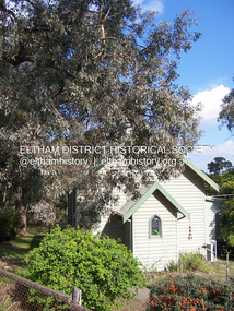 Eltham District Historical Society Inc
Photograph - Digital Photograph, Marguerite Marshall, Former Methodist Church, Plenty, 5 August 2008
In 1924, the Methodist Church opened at the corner of River Ave and Yan Yean Road, Plenty. It was a simple weatherboard gabled building. The church developed a strong community life with celebrations as well as worships, Sundays Schools and social events. It closed in 1979. Covered under Heritage Overlay, Nillumbik Planning Scheme. Published: Nillumbik Now and Then / Marguerite Marshall 2008; photographs Alan King with Marguerite Marshall.; p113 In 1924, the Methodist Church, (which closed in 1976), opened at the corner of River Avenue and Yan Yean Road. Church members including George Starling and Ernest Osmond, built the simple weatherboard gabled building.3 The church developed a strong community life, with celebrations as well as worship through Sunday School anniversaries, picnics, harvest festivals and youth groups. Many volunteers worked hard for the church - teaching Sunday School and ferrying young people to events, sometimes in the backs of trucks and furniture vans. Children from the Sutherland Homes were brought to church by their Matron – a ‘grim martinet’! Members included the Ashton, Reid, Harris, McLachlan, Hopkin, Rose and Stuchbery families. The first wedding was for Vida McLachlan and Ray Stuchbery.4This collection of almost 130 photos about places and people within the Shire of Nillumbik, an urban and rural municipality in Melbourne's north, contributes to an understanding of the history of the Shire. Published in 2008 immediately prior to the Black Saturday bushfires of February 7, 2009, it documents sites that were impacted, and in some cases destroyed by the fires. It includes photographs taken especially for the publication, creating a unique time capsule representing the Shire in the early 21st century. It remains the most recent comprehenesive publication devoted to the Shire's history connecting local residents to the past. nillumbik now and then (marshall-king) collection, methodist church, plenty -
 Eltham District Historical Society Inc
Photograph - Digital Photograph, Alan King, St Andrews Hotel, 2 February 2008
The c1860 St Andrews Hotel, with the c1930 additions, and the Canary Island Palm, and the surrounding site to the title boundaries are historically, socially and aesthetically significant to the Shire of Nillumbik. The St Andrews Hotel is historically significant because it may have given its name 'St Andrews' to the town (another suggestion is that the name came from St Andrews church) and for its connection to Ewen Hugh Cameron (1831-1915) the prosperous local farmer, member of the Eltham Roads Board/Shire Council and local MP. It is also significant as the oldest hotel building in the former Shire of Eltham, as one of the few surviving buildings connected with the Caledonian goldfields era and as one of a handful of early structures to have survived the 1960s bushfires; the additions and alterations to the hotel reflect its long life. The hotel is socially significant because it has served as an important meeting place for more than 160 years. The Canary Island Palm is historically significant as a rare example of exotic tree planting in this rural area. The tree is aesthetically and historically significant as a local landmark and for its contribution to the streetscape and landscape value. Covered under Heritage Overlay, Nillumbik Planning Scheme. Published: Nillumbik Now and Then / Marguerite Marshall 2008; photographs Alan King with Marguerite Marshall.; p71 Built around 1860, St Andrews Hotel has changed little since it first welcomed thirsty gold diggers from the Caledonia Goldfields. The timber building, with gabled roof, beamed ceilings and a massive fireplace, is Nillumbik Shire’s oldest hotel and has always been an important community centre, particularly in its early days. Fortunately, the hotel and the near-by Canary Island Palm Tree, which is quite rare in this area, survived the 1960s bushfires, along with a few other early buildings. St Andrews (formerly Queenstown) was founded on gold, as were Panton Hill (formerly Kingstown), Research and Diamond Creek, from the mid-1850s to the 1860s. But by the early 20th century common use changed the name Queenstown to St Andrews, possibly after this hotel or after the church or the mining district.1 The Caledonia Diggings were probably named by Scottish settlers after the Roman name for Scotland, despite this land bearing little similarity to their homeland.2 Queenstown, which was proclaimed as a township in 1861, was the gold-mining centre on the Upper Diamond and in the 1850s had up to 600 European inhabitants and a small camp of Chinese on the flats along the creek. Queenstown was the administrative centre of the Upper Diamond with three hotels, a brewery and a slaughterhouse.3 It is unclear which hotel was the district’s first, as distinct from the earliest unlicensed grog shops, some of which operated in tents. John Corke Knell was one of eight unlicensed storekeepers supplying drink to miners at Caledonia in 1857, named by Sgt. McNamara of the Caledonia Police Station.4 In February 1859, Knell apparently bought most of the present hotel’s site at the first township land sales. As he was a local storekeeper, he might have first established a store there.5 Knell and his wife Eliza were early licensees of the St Andrews Hotel. The hotel had eight bedrooms – including three for public use – and the dining-room seated 30 people. It is thought they named the hotel St Andrews after Eliza’s hometown of St Andrews in Scotland. St Andrews Hotel was an important local centre in several ways. In the same building the Knells also operated a post office and general store. In 1867 Mrs Knell was appointed Deputy Registrar of Births and Deaths for Queenstown. The hotel was also used to hold inquests into people’s deaths when the police residence became too small.6 The hotel also became a fashionable destination at Christmas for parties from Melbourne. In 1868, possibly following her husband’s death, Mrs Knell applied for a temporary licence, which was then transferred to Robert Smith after their marriage in 1869. But then, possibly after Robert’s death, Mrs Smith operated the hotel until 1892. This contradicts a report in The Evelyn Observer 1882 that JC Knells of the St Andrews Hotel was granted a publican’s licence in the Queenstown Police Court. At that time he was supposed to have been dead for around 14 years! Although Mrs Smith was a respected citizen, known for her geniality and as an ideal hostess, she had a minor brush with the law when she was fined ten shillings for not lighting a lamp outside her licensed premises.7 From 1892 several publicans owned the hotel including W Atkins, from 1895. In 1909 the licensee was apparently Mrs Smith’s son, Walter Knell, who held the licence until at least the 1920s. Not surprisingly, this old hotel has attracted romantic stories. Mrs Smith is said to be seen roaming the pub in her nightdress – even though she was buried in the Queenstown Cemetery in 1911.8 A musical The Hero of Queenstown, set in the hotel, was written and produced by local actor Reg Evans in the 1970s.This collection of almost 130 photos about places and people within the Shire of Nillumbik, an urban and rural municipality in Melbourne's north, contributes to an understanding of the history of the Shire. Published in 2008 immediately prior to the Black Saturday bushfires of February 7, 2009, it documents sites that were impacted, and in some cases destroyed by the fires. It includes photographs taken especially for the publication, creating a unique time capsule representing the Shire in the early 21st century. It remains the most recent comprehenesive publication devoted to the Shire's history connecting local residents to the past. nillumbik now and then (marshall-king) collection, st andrews hotel -
 Eltham District Historical Society Inc
Photograph - Digital Photograph, Alan King, St Matthew's Church and Hall, Panton Hill, 27 March 2008
St. Matthew's Church has historic significance as the town's church and physical and social focus for the community. The standard design buildings are good examples and important streetscape elements. The war memorial cross is the area's monument to the 20th century wars and its modest scale in comparison with the granite Eltham and towered Kangaroo Ground memorials illustrates the lack of affluence in the town and surrounding area. The grouping of church, school, store and post office is typical of country villages throughout Victoria. The Radiata Pine plantings are significant as an intact line of shelterbelt planting typical of the early 20th century. (Bick Study 1992) Covered under Heritage Overlay, Nillumbik Planning Scheme. Published: Nillumbik Now and Then / Marguerite Marshall 2008; photographs Alan King with Marguerite Marshall.; p63 Panton Hill’s first church services were held in a simple building made of paling timber, opposite the Hotel de France. The building was also used for Sunday School, a school and a hall.1 The St Matthew’s Church and hall at the corner of Church Road and Kangaroo Ground-St Andrews Road, were built in the early 20th century in the standard rectangular style of the times. The intact belt of Radiata Pines was common at that time. The war memorial concrete cross is the area’s monument for the 20th century wars. It is much more modest than those in Eltham, and particularly in Kangaroo Ground, demonstrating those townships’ comparative affluence.2 Early settler J Hughes, who donated the land to the Church of England, was the first to be married at St Matthews when he married Rachel Coutie. In later life he became a minister of religion.3 One much-liked preacher was George Hollow, who with his sister playing the harmonium, conducted church services at Panton Hill, St Andrews and Christmas Hills, for many years.This collection of almost 130 photos about places and people within the Shire of Nillumbik, an urban and rural municipality in Melbourne's north, contributes to an understanding of the history of the Shire. Published in 2008 immediately prior to the Black Saturday bushfires of February 7, 2009, it documents sites that were impacted, and in some cases destroyed by the fires. It includes photographs taken especially for the publication, creating a unique time capsule representing the Shire in the early 21st century. It remains the most recent comprehenesive publication devoted to the Shire's history connecting local residents to the past. nillumbik now and then (marshall-king) collection, panton hill, st matthew's church, panton hill war memorial -
 Eltham District Historical Society Inc
Photograph - Digital Photograph, Alan King, Kinglake National Park, 27 March 2008
Fern gullies around Jehosaphat Gully Covered under National Estate. Published: Nillumbik Now and Then / Marguerite Marshall 2008; photographs Alan King with Marguerite Marshall.; p125 The magnificent Kinglake National Park, fringing Nillumbik’s north, is the largest national park close to Melbourne. Thanks to the vision and hard work of a band of local people, the park was created from what was rapidly becoming degraded land. Seeing a threat to Kinglake’s indigenous flora and fauna, several prominent local people campaigned for a national park, which was established in 1928.1 Since then, the park has grown through donations and acquisitions of land, from around 13,800 acres of land (5585ha) to 22,360 hectares. The Sugarloaf and Everard Blocks – of almost 8000 hectares – stand in Nillumbik and the park extends into Mitchell and Murrundindi Shires and the City of Whittlesea. Mt Everard commemorates William Hugh Everard, State member for Evelyn when the park was established. Before 1928, European settlers had degraded the Kinglake area, which was named after the celebrated English author and lawyer, Alexander William Kinglake. Remains of gold shafts and diggings in the park are reminders of Kinglake’s first settlers, who hoped to strike it rich at the gold diggings. But like other gold fields in this shire, they proved not very lucrative and soon timber cutting replaced mining in importance. However, before long, the accessible timber supply ran out, so in the 1920s agriculture took over – particularly potatoes and berry fruits – which involved large-scale clearing.2 The park’s instigator was retired Melbourne University Professor of Music, William Laver.3 As chair of the Kinglake Progress Association he began negotiations to have crown lands on the southern scarp of the Great Dividing Range reserved as a national park. Even before the park was proclaimed, from 1927, KPA members cut tracks to the major scenic points. Professor Laver was one of several people who gave land for the park, donating around 50 acres (20ha), including the Jehosaphat Gully.4 Laver chaired the park’s first Committee of Management, which raised money to employ a ranger and provide facilities, including tracks and roads for fire protection vehicles, toilets and shelters. The committee charged fees for firewood collection, some grazing of livestock, and visitor entrance, and obtained small State Government and Eltham Shire grants. In 1957 the State Government provided revenue for national parks. Then, in 1975, the State Government took over the management and the Committee of Management became an advisory committee, which disbanded in 1978. Originally, the park covered crown land in the Shires of Eltham and Whittlesea; then Wombelano Falls in Yea and other areas were added. In 1970 the park extended into the Shires of Eltham, Healesville, Whittlesea and Yea.5 Bush fires have been an ongoing problem. In 1939 hundreds of eucalypts and acacias had to be sown around the Jehosaphat Gully to rejuvenate the forest. To manage bushfires, the Committee of Management, then the State Government, worked closely with the Forestry Commission, shire councils and local fire brigades. Early national parks focussed on recreation. But by the 1980s, conservation, education and scientific research became more important, playing a vital role in preserving representative samples of the natural environment. Each year many thousands of people use the park’s extensive network of walking tracks amongst the protected plant and animal life as well as camping, cycling and horse riding. The park, along the slopes of the Great Dividing Range, has lookouts revealing magnificent views of the Melbourne skyline, Port Phillip Bay, the Yarra Valley and the You Yangs. Vegetation in the Masons Falls area includes messmate forest, Austral grass-trees, ferns and Hazel Pomaderris. In spring, orchids, lilies, everlasting daisies, correas, grevillea and heath appear. Around Jehosaphat Gully are wet and dry forest, fern gullies and banksia. Animal life includes wallabies, kangaroos, koalas, echidnas, possums, gliders and bandicoots. Male lyrebirds can be heard mimicking in the Jehosaphat Gully, particularly in the Everard Block in winter.This collection of almost 130 photos about places and people within the Shire of Nillumbik, an urban and rural municipality in Melbourne's north, contributes to an understanding of the history of the Shire. Published in 2008 immediately prior to the Black Saturday bushfires of February 7, 2009, it documents sites that were impacted, and in some cases destroyed by the fires. It includes photographs taken especially for the publication, creating a unique time capsule representing the Shire in the early 21st century. It remains the most recent comprehenesive publication devoted to the Shire's history connecting local residents to the past. nillumbik now and then (marshall-king) collection, kinglake national park, jehosaphat gully -
 Mrs Aeneas Gunn Memorial Library
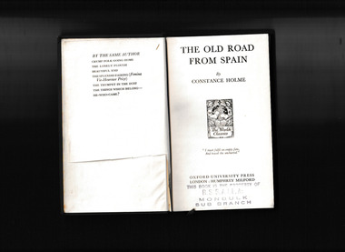
Book, Oxford University Press, The old road from Spain, 1932
... , social life, and rural traditions of Holme’s native Westmorland ...The landscape, social life, and rural traditions of Holme’s native Westmorland are vividly evoked in The Old Road from Spain, the story of two brothers. When the younger brother arrives home from Spain it disrupts the even tenor of life in their Westmorland home. Meanwhile, a wreck in Morecambe bay links the story back to the Spanish Armada.p.282.fictionThe landscape, social life, and rural traditions of Holme’s native Westmorland are vividly evoked in The Old Road from Spain, the story of two brothers. When the younger brother arrives home from Spain it disrupts the even tenor of life in their Westmorland home. Meanwhile, a wreck in Morecambe bay links the story back to the Spanish Armada.england - adventure fiction, english fiction -
 Orbost & District Historical Society
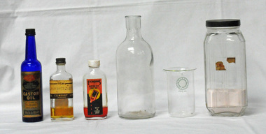
glass containers, first half 20th century
These items were used at the pharmacies in Orbost. Chemists who worked in Orbost included Henry Cottman; James Alfred Dubois Williams; Harry Arthur Murray; Miss P.E .Mason (Phyllis Estelle?); Miss Sybil Monica Buzza; Thomas James Frazer; Australia Shaw; James David Torley; John William Zimmer; Dalkeith William Steele; William Thomas Hollingsworth; E.E. Cohen; R.S. Anderson; Frances John Perry Faith Everard Pardew and Charles Anthony Wurf. Castor oil and Eichorn's Remedy were home based remedies for non life threatening injuries. The practices of early pharmacists are revealed through these glass containers. The items have a clear association with Orbost and indicate that many rural households had first-aid sources. .Six glass containers. 3210.7 is a deep blue coloured glass bottle. It has a narrow neck and a screw on lid. It has an embossed manufacturer's name, logo and contents (Castor Oil) on one side and identification marks embossed on the underside. 3210.8 is a small clear glass flat bottle with a metal top.It is labelled "SIGMA JUNIPER BACC'. It contains pale brown liquid 3210.9 is a a small moulded clear glass flat bottle with a white bakelite cap.It is labelled "EICHORNS REMEDY 100 ml HELP IN EVERY DROP". 3210.10 is a clear glass bottle with no lid.It has embossed manufacturer's stamp on base. 3210.11 isa clear glass beaker with a label on the front of two concentric green circles inside of which is "PYREX Made in England" with 200 ml below this. 3210.12 is a lear glass jar / bottle with a black lid. The front and sides are ridged with part of a label - "CAL". This bottle contains some pink powder.3210.7 - "Rolfes Medicinal Tasteles Castor Oil - Rolfe & Co King St Melbourne. Contents 5oz" 3210.8 - "SIGMA JUNIPER BACC SIGMA COMPANY LIMITED, Melbourne" 3210.9 - "EICHORNS REMEDY 100 mm Help in Every Drop" 3210.10 - on base -"J983 / M 2 " 3210.11 - "PYREX Made in England 200 ml" 3210.12 - "CAL"glass-containers pharmacies-orbost medicines chemists-orboet -
 Whitehorse Historical Society Inc.
Document - Interview Transcript, Williams, Louise, David and Joan Ikin, 24/02/2020
A transcript of an interview with David and Joan Ikin of 5 Jeffery Street, Blackburn on the 24 February 2020. the interview was conducted by Louise Williams of WHS. It includes descriptions of wildlife, fauna and streetscapes from 1965 onwards.A transcript of an interview with David and Joan Ikin of 5 Jeffery Street, Blackburn on the 24 February 2020. The interview was conducted by Louise Williams of WHS. It includes descriptions of wildlife, fauna and streetscapes from 1965 onwards.non-fictionA transcript of an interview with David and Joan Ikin of 5 Jeffery Street, Blackburn on the 24 February 2020. the interview was conducted by Louise Williams of WHS. It includes descriptions of wildlife, fauna and streetscapes from 1965 onwards.williams louise, savage janet, ikin david and joan, satchwell, jeffery street blackburn, clayton ann, huntsman keith, huntsman robin, blackburn lake -
 Bendigo Historical Society Inc.
Book - BOOK - THE IRISH CHIEFTAN
1. Patterned green cloth over cardboard cover. Titled The Irish Chieftan or the isles of Life and Death, by Edward Maturin, Esq. Inscribed inside book on flyleaf: Presented to James Adamson, by his youngest sister Sarah Adamson. June 9, 1862, Sunderland.book, rural, the irish chieftan., historical -
 Eltham District Historical Society Inc
Photograph - Digital Photograph, Marguerite Marshall, Eltham Retirement Centre (Judge Book Memorial Village), Diamond Street, Eltham, 23 October 2006
Thousands of elderly people at this centre have contributed much. Published: Nillumbik Now and Then / Marguerite Marshall 2008; photographs Alan King with Marguerite Marshall.; p161 Thousands of elderly people, who have contributed much to Nillumbik and beyond, have made their home in the treed Eltham Retirement Centre. The centre, which opened in 1956, has housed the disadvantaged in particular, through good times and hard, including floods, fire and even burglaries. As part of the Melbourne Citymission, a non-denominational Christian organisation that cares for people living with disadvantage, the centre was built to celebrate 100 years of the Melbourne Citymission’s work since 1854. Standing on a former poultry farm called Willandra (Still Waters), the centre includes independent units, hostel, nursing home accommodation and a Day Therapy Centre, which is available for non-residents as well. Despite being metres from the busy Main Road and railway station, the centre provides a quiet oasis on 6.8 hectares bordered by the Diamond Creek to the west, and the railway line to the east. The centre was originally named Judge Book Memorial Village after Judge Clifford Book, Deacon of the Collins Street Baptist Church. Book was also President of the Baptist Union of Victoria and Grand Master of the Masonic Lodge. He was so respected that, at his death, several Pentridge prisoners asked to attend his funeral. In 1993 the centre’s name was changed to clarify that it was part of the Melbourne Citymission. However Judge Book’s name continues in the Judge Book Memorial Garden, opened in 2006. The Diamond Creek has flooded the centre several times, however rarely causing serious damage. Volunteer Alan Field recalls a flood in 1974 when the resident manager Reverend Norman Pearce and his wife, were rescued by boat from their home with their budgerigar. On February 3, 2005, when the creek almost flooded Metzner Hall, 35 ambulances evacuated residents to nearby nursing homes, hostels and local homes. Residents were also evacuated during the 1965 bush fire, but fortunately a change of wind direction saved the centre. Residents have also endured several burglaries. Despite much rebuilding and modernisation over the years, traces of the original farmhouse remain in the administration areas. In 1991 the Willandra Hostel was built and in 2001 the Eltham Lodge Nursing Home with each room having a garden view. Several buildings are named after people who have given special service to the centre including the Norman Pearce Day Hospital after general manager and pastor Rev Pearce. Metzner Hall was named after the Metzner family who had been active in the auxiliary since it began and had donated generously to the Recreation Hall fund.3 A bridge was named after Sister Lila Murray who had worked at the village for 42 years in various capacities including as relieving manager. Field remembers Sister Murray as ‘the Mother Teresa and soul of what the village aspired to, with love and care’. Since 1957 the Eltham Auxiliary, later called the Residents’ Association, has worked to improve the residents’ quality of life by volunteering and raising funds. An outstanding volunteer, Field, who was drawn to the centre in 1971 with his wife Chris, has held positions on the early Eltham boards, auxiliaries and Residents’ Association. Much of his work has been supporting people with no family and those of limited means. He says he and his wife look at their work as having shared ‘our lives with amazing people’. The wealth of experience and wisdom in the Retirement Village has benefited many people, including local school children. Residents have acted as proxy grand-parents at local schools, by assisting small learning groups or telling their life stories. Conversely, students from local schools have visited to perform, or to assist in programs like craft activities. Resident Val Bell, whose mother Rose Bullock lived at the centre before her, sums up the centre’s most important attribute for her: ‘The Christian care. They could not be more caring’.This collection of almost 130 photos about places and people within the Shire of Nillumbik, an urban and rural municipality in Melbourne's north, contributes to an understanding of the history of the Shire. Published in 2008 immediately prior to the Black Saturday bushfires of February 7, 2009, it documents sites that were impacted, and in some cases destroyed by the fires. It includes photographs taken especially for the publication, creating a unique time capsule representing the Shire in the early 21st century. It remains the most recent comprehenesive publication devoted to the Shire's history connecting local residents to the past. nillumbik now and then (marshall-king) collection, diamond street, eltham, eltham retirement centre, eltham retirement village, judge book memorial village -
 Bacchus Marsh & District Historical Society
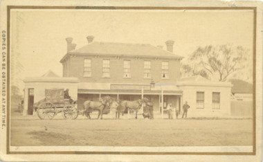
Photograph, Border Inn, Main Street Bacchus Marsh 1883
The Border Inn located on the corner of Main Street and Graham Street Bacchus Marsh opened in 1851 making it a very early hotel in Victoria. It was built and owned by John Pilmer. The first licensee was James Watt. The building has been added to and changed many times. It was originally a single storey building. A second storey was added in 1863 by John Pilmer. In 1866 the hotel was purchased by Edward Jones. The Jones family owned and operated the hotel until 1939. Additional second storey sections were added in 1883, 1904 and 1936. For a number of years the Border Inn was a stopping post for coaching services between Melbourne and Ballarat. The first licensee of the hotel James Watt was among the first in Victoria to offer a regular coaching service and his hotel was used for overnight accommodation by coach travellers. At the time this picture was taken coach services were still operating between Bacchus Marsh and other locations. The coach in this picture is possibly one of those coaches.This building has been documented as of state significance by Richard Peterson and Daniel Catrice in their 1995 heritage study for the then Shire of Bacchus Marsh. Their assessment of the heritage significance of the building was: "The Border Inn is of state historical significance as a pioneering pre-gold rush building, on the route to the Ballarat goldfields. It is the representative-embodiment of several historical periods and their way of life. It demonstrates a complex changing sequence of patterns of occupancy and architectural styles. Its development at this location, demonstrates the effect of a social movement, the gold rush, as a transport stopover.It is also historically significant for its association with the first rural public transport in Victoria. Locally, the hotel is significance for its association with the first meeting of municipal government, and also for its social significance as a traditional community, visitor focus and meeting place".Small sepia unframed photograph on card with gold border framing photograph. Housed in the album, 'Photographs of Bacchus Marsh and District in 1883 by Stevenson and McNicoll'. The image shows the Border Inn Hotel at an angle depicting the front of the building facing directly to the camera. It is a two storey brick building, with one-story additions at either end. Five chimneys can be seen extending from the building. The bottom storey has a verandah extending onto the footpath. A covered wagon, probably a coach, with four horses in harness is in front of the building. There are several people in the image. Two people are sitting on the driver’s seat of the wagon. Another man is standing holding the reins of the horses. At his feet is a dog. Behind them are two male adults. One is holding a small child. A young boy stands beside him.On the front: Stevenson & McNicoll. Photo. 108 Elizabeth St. Melbourne. COPIES CAN BE OBTAINED AT ANY TIME. On the back: LIGHT & TRUTH inscribed on a banner surmounted by a representation of the rising sun. Copies of this Portrait can be had at any time by sending the Name and Post Office Money Order or Stamps for the amount of order to STEVENSON & McNICOLL LATE BENSON & STEVENSON, Photographers. 108 Elizabeth Street, MELBOURNE. stevenson and mcnicoll 1883 photographs of bacchus marsh and district, hotels bacchus marsh, border inn hotel bacchus marsh, carriages and coaches, stagecoaches, james watt bacchus marsh, john pilmer bacchus marsh, edward jones family bacchus marsh -
Lakes Entrance Historical Society
Book, Adams John, Path Among the Years - History of Bairnsdale, 1987
A collection in words and pictures of the events and people that have made the history of the Shire of Bairnsdale, from the Aboriginal, pastoral, settlers to the many aspects of life in the towns and rural areas in 1987settlers, schools, religion -
 Narre Warren and District Family History Group
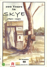
Book, Dot Morrison, 100 years in Skye 1850-1950, 2004
The book 100 Years in Skye, 1850-1950 by Dot Morrison explores the history of Skye in a detailed account of the area's development over a century, including its social, economic, and cultural changes. The book's illustrations, maps, and photographs offer a vivid portrayal of life in Skye during this period. Includes an index and bibliography.99 p.; 29 cmnon-fictionThe book 100 Years in Skye, 1850-1950 by Dot Morrison explores the history of Skye in a detailed account of the area's development over a century, including its social, economic, and cultural changes. The book's illustrations, maps, and photographs offer a vivid portrayal of life in Skye during this period. Includes an index and bibliography.skye (vic.), skye (vic.) -- history, skye (vic.) -- road names, wedge family, skye (vic.) -- murders, south lyndhurst state school -
 Narre Warren and District Family History Group
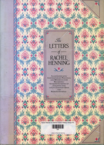
Book, Rachel Henning, Letters of Rachel Henning, 1986
From the comfort and culture of rural England with its ordered estates and "green lanes and fields", to the dusty heat of a rough, unfloored cabin in outback Queensland — that is just part of the journey Rachel Henning made and reports on in her letters. Yet these reveal no sorry tale of struggle in adversity — amazingly they form a lively adventure story and a vivid family saga. Expertly edited by David Adams, a former editor of the Sydney Bulletin magazine, the collection reads like a novel — partly of courtships and romances, partly of the progress of a pioneering family, and partly of Rachel Henning's own progress towards acceptance of her new way of life. The letters were first published in the Bulletin in 1951 and were so well received that they were quickly presented in book form. Thereafter they have scarcely been out of print and the grace, liveliness and gossipy intimacy of Rachel's prose have earned them a unique place in Australian literature. This edition is illuminated with illustrations of the period - some believed to be by Rachel herself, others by members of her family and others by artists and sketchers who would have been Rachel's contemporaries. Wherever possible, the work of women has been included. Taken from sketchbooks and note pads, their often unfinished images give as intimate a view of life in Australia from the 1850s to the 1880s as do Rachel's letters. (Inside Cover)non-fictionFrom the comfort and culture of rural England with its ordered estates and "green lanes and fields", to the dusty heat of a rough, unfloored cabin in outback Queensland — that is just part of the journey Rachel Henning made and reports on in her letters. Yet these reveal no sorry tale of struggle in adversity — amazingly they form a lively adventure story and a vivid family saga. Expertly edited by David Adams, a former editor of the Sydney Bulletin magazine, the collection reads like a novel — partly of courtships and romances, partly of the progress of a pioneering family, and partly of Rachel Henning's own progress towards acceptance of her new way of life. The letters were first published in the Bulletin in 1951 and were so well received that they were quickly presented in book form. Thereafter they have scarcely been out of print and the grace, liveliness and gossipy intimacy of Rachel's prose have earned them a unique place in Australian literature. This edition is illuminated with illustrations of the period - some believed to be by Rachel herself, others by members of her family and others by artists and sketchers who would have been Rachel's contemporaries. Wherever possible, the work of women has been included. Taken from sketchbooks and note pads, their often unfinished images give as intimate a view of life in Australia from the 1850s to the 1880s as do Rachel's letters. (Inside Cover)colonial life, rachel henning, letters -
 Narre Warren and District Family History Group
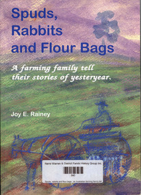
Book, Joy E Rainey, Spuds, rabbits and flour bags : an Australian farming family tell their stories of yesteryear, 2006
... illustration of life in an Australian rural family pre and post ...More than a history. A vivid illustration of life in an Australian rural family pre and post the thirties depression and World War II. Spoken in their own words with humour and feeling, recorded thoughtfully and sensitively. This book is not only entertaining, it is real life! Days of big draught horses, when a man's word was his bond, and doors were left unlocked. Real, readable, challenging for the every day reader and serious student. (Back Cover)non-fictionMore than a history. A vivid illustration of life in an Australian rural family pre and post the thirties depression and World War II. Spoken in their own words with humour and feeling, recorded thoughtfully and sensitively. This book is not only entertaining, it is real life! Days of big draught horses, when a man's word was his bond, and doors were left unlocked. Real, readable, challenging for the every day reader and serious student. (Back Cover)farmers, victoria, bruton family -
 Wooragee Landcare Group
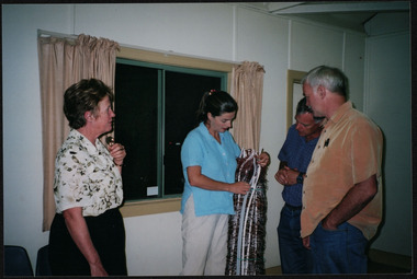
Photograph, 27th February, 2004
This photograph was taken at Wooragee Hall on the Friday 27th February, 2004 as part of an event called Foxy Night Out. This event was about sharing awareness about the impacts of foxes in rural areas and discussing methods to control their populations. There were two mains speakers at this event, the first; Camille Veselsky, a specialist in fox behaviour who worked for the Hume Rural lands Protection Board on pest animal control, and the second; Leanne Wheaton, a nature conservationist. Pictured in this photograph (left -right): Mary Prowse, Leanne Wheaton, Tony Prowse, Ray Henderson. Leanne Wheaton holds a portable electric fence, that is useful in preventing fox attacks on wildlife, including Bush Stone-Curlew nests Regional areas like Wooragee are susceptible to fox attacks due to the availability of food such as rubbish, scraps, native wildlife and livestock. Foxes can have a huge impact on native wildlife and domestic life as they are known to chew through irrigation systems, dig-up and defecate in gardens, raid rubbish bins and harass other domestic animals.This photo is a record of the events that Wooragee Landcare organises in order to raise awareness and educate about environmental conservation issues in the area. It shows practical solutions that have been considered in fox controlLandscape coloured photograph printed on gloss paperReverse: WAN NA 0A2A0N0 NNN+ 1 6329 / [PRINTED] (No.6A) / 497 wooragee, wooragee hall, wooragee landcare, wooragee landcare group, fox, foxy, foxy night out, leanne wheaton, mary prowse, tony prowse, ray henderson, wheaton, prowse, henderson, electric fence, portable electric fence, landcare workshop, fox control project