Showing 844 items
matching surveyors
-
 Ringwood and District Historical Society
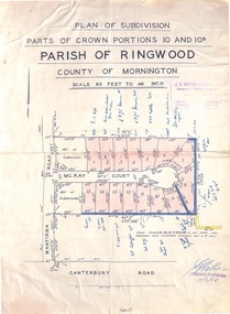
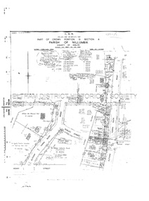
Map - Plan of Subdivision, Parts of Crown Portions 10 and 10B Parish of Ringwood - 1958
Folded subdivision map of 15 residential allotments in McKay Court Ringwood, off Wantirna Road north of Canterbury Road. Rubber stamped by Surveyors and Chartered Engineers J.S. Watson & Associates, Mornington and South Yarra, with illegible signature dated 17/2/58. Handwritten notations indicating allotment sale names and amounts or where passed in.Scale 80 feet to an inch. -
 Bendigo Historical Society Inc.
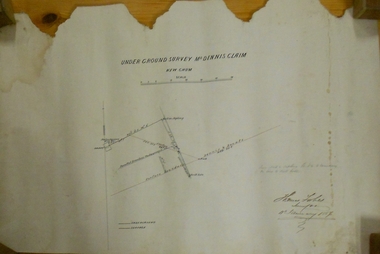
Plan - MARKS COLLECTION: UNDERGROUND SURVEY MR. DENNIS CLAIM NEW CHUM
Plan on heavy parchment paper. On top of plan 'underground survey Mr. Dennis, New Chum' Signed: Thomas Forbes, Surveyor, 11th. January 1867. shows surface boundary of Dennis and Bonati. Written in blue pencil 'From nail in sapling 33f. 51/2 to boundary. Online to drill hole' Shaft marked on LH boundary.'bendigo, mining, mr. dennis claim, new chum -
 Bendigo Historical Society Inc.
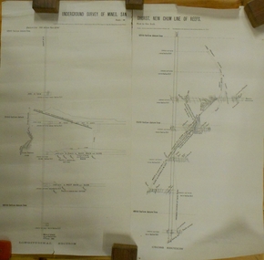
Plan - MARKS COLLECTION: UNDERGROUND SURVEY OF MINES SANDHURST NEW CHUM LINE OF REEF
Plan, divided into two sheets, on top of sheet Underground survey of mines Sandhurst, New Chum Line of Reef. Surveyed by Caleb Thomas under the direction of Charles W. Langtree, Acting Secretary for Mines and Water Supply and Acting Chief Mining Surveyor for the Colony of Victoria. Drawn by Arthur Everett, Mining Department, Melbourne, 1884.bendigo, mining, new chum line of reef -
 Greensborough Historical Society
Map - Map (Copy), C. Hodgkinson, District Surveyor et al, Parish of Yan Yean 1856: Village site during construction of the Yan Yean Reservoir, 1978
Copy of map part Sec. 13, Parish of Yan Yean 1856, Map 3, Village site... Scale: 8 chains to 1 inch. Drawn by C. Hodgkinson, District Surveyor, redrawn by A. R. Blair 1978. 1 p. photocopy of map. yan yean reservoir, yan yean -
 Nillumbik Shire Council
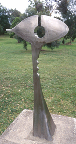
Public Art: Ernst FRIES (b.1934 Wurzburg, Germany - arrived 1959 Aus), Ernst Fries, Surveyor of Suburban Environs, Location: Alistair Knox Park, Main Road, Eltham, 1991
'Surveyor of Suburban Environs' was one of the acquisitions from the 1991 Eltham Art Awards (now known as the Nillumbik Prize - and formally the Nillumbik Art Awards). This was the first piece acquired from this award which was suitable for a public space. Nillumbik is referred to as the "Green Wedge" and the sculpture "Surveyor of Suburban Environs" suggests a watchful observer of the surrounding landscape. The sculpture's central motif represents an eye held up on a pedestal by a tail. Its form has been likened to the Eye of Horus, an ancient Egyptian symbol of protection, royal power and good health personified in the goddess Wadjet or 'green one'. This likeness would suggest that the observer or surveyor has a divine status and spiritual connection to its environment. Polished stainless steel sculpture comprising an eye reminiscent of ancient egyptian hieroglyphics, which is held up with a tappered and jaggered tail like pedestal. Concrete base. N/Apublic art, fries, spiritual, eye, stainless steel, goddess, surveyor, sculpture, environment -
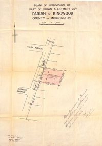 Ringwood and District Historical Society
Document, Plan of Subdivision - Part of Crown Allotment 26A, Parish of Ringwood, County of Mornington - Circa 1961
Map showing layout of 2 allotments coloured red in Velma Grove, adjacent to Valda Avenue and Mirabel Avenue, Ringwood East, Vic.Handwritten notation dated 29/8/1961 by Alf King, Licensed Surveyor, 14 Grace Street, Mont Albert (Phone) WX2020 regarding plans being forwarded to Council for inspection visit. -
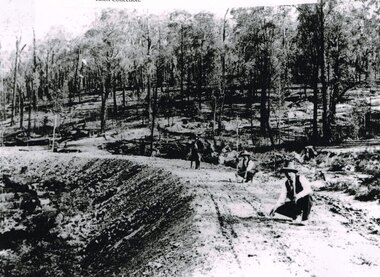 Otway Districts Historical Society
Photograph, Knox Collection, Surveying construction near Barongarook, 1900, 1900
In 1898 a recommendation for a railway of 2 ft 6 in gauge was handed down by the Parliamentary Standing Committee on Railways, to cost $138,000. Construction of the Colac-Beech Forest railway line began in 1900. About 100 men were employed in laying and ballasting the track while others formed the earthworks and the building of culverts and bridges. The earthworks of gravel ballast 150 mm deep were formed by horse and scoop or by shovel. Once the bed had been laid surveyors went along to check the layout, particularly all check rail curves and all 100 metre curves which the surveyors in the picture are doing.B/W. Three men surveying the construction of a curved bed on which track will be laid, near Barongarook, Victoria.colac; beech forest; barongarook; railways; -
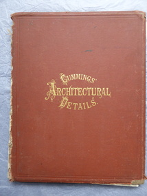 Warrnambool and District Historical Society Inc.
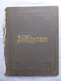
Book, Cummings Architectural Details, 1873
This book was owned by John Crawley, engineer, architect and surveyor. He was appointed District Engineer for the Public Works Department for the Western District in 1866. He was the Shire of Warrnambool Engineer from 1874 to 1895 when he was succeeded by his son.This book is of interest as it contains examples of architectural designs from U.S.A. in the 1870s. Designs such as these influenced the designs of buildings in other countries including Australia. This book is also of interest because of its connection to John Crawley, a member of the Crawley family that had a long and influential association with the Shire of Warrnambool.This is a hard cover book. It has a brown cover with gold lettering. The book has come apart from its binding so many of the pages are loose and the covering on the spine is missing . The front cover is somewhat stained and the edges are worn. The book has many diagrams and illustrations.The inscriptions are handwritten in black ink J. W. Crawley Warrnambool J.W. Crawley 1879john crawley -
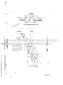
 Eltham District Historical Society Inc
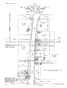
Document - Survey Plan, Country Roads Board, SP 6801, Eltham-Yarra Glen Road; Brougham St to Bridge St, 1958
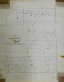
1958 C.R.B. Plan of Survey of Part of Crown Portion 12 Section 4 Parish of Nillumbik, County of Evelyn Eltham-Yarra Glen Road, Shire of Eltham Shows Surveyor field notes, property ownership and building type and construction.a.j. collis, a.s. & c.g.h. fitzpatrick, board of land & works, bridge street, brougham steet, commonwealth bank of australia, country roads board, eltham, eltham rsl sub-branch, f.h. collis, f.m. smith, f.n. & e.j. burgoyne, franklin street, h.c. & r.e. burgoyne, j. jorgenson, j.f. & j.e. morris, j.n. & h.c. burgoyne, j.s. blow, john street, main road, p.e. smith, pitt street, r.j. dripps, s.j. taylor, survey plan, trustees of the eltham methodist church, 1958, eltham-yarra glen road, neil webster collection -
 Eltham District Historical Society Inc
Document - Survey Plan, Country Roads Board, SP 6802, Eltham-Yarra Glen Road; Brougham St to Dalton St, 1958
1958 C.R.B. Plan of Survey of Part of Crown Portion 12 Section 4 Parish of Nillumbik, County of Evelyn Eltham-Yarra Glen Road, Shire of Eltham Shows Surveyor field notes, property ownership and building type and construction.1958, eltham-yarra glen road, a.f. munday, bible street, brougham steet, country roads board, dalton street, eltham, j.p. & e.a. sanders, j.w. & e. m. graham, l.c. skipper, l.m. jarrold, main road, napoleon street, survey plan, neil webster collection, franco and co -
 Eltham District Historical Society Inc
Document - Survey Plan, Country Roads Board, SP 6313, Eltham-Yarra Glen Road; Luck St to Henry St, 1956
1956 C.R.B. Plan of Survey of Part of Crown Portion 13 Section 4 Parish of Nillumbik, County of Evelyn Eltham-Yarra Glen Road, Shire of Eltham Shows Surveyor field notes, property ownership and building type and construction.eltham-yarra glen road, country roads board, eltham, main road, survey plan, 1956, a.l. lyon, a.w. brinkkotter, arthur street, c.r. burkett, dudley street, e.n. staff, eltham war memorial trust, henry street, luck street, pryor street, the board of land & works, the equity trustees executors and agency coy ltd, the roman catholic trusts corporation, victorian railways commision, neil webster collection -
 Federation University Historical Collection
Book, Memoirs of the Geological Survey of Victoria No 14 The Ballarat Goldfields, 1923, 1923
William Baragwanath was educated at the Ballarat School of Mines, obtaining a Geology Certificate in 1911. After further study he went on the become Secretary for Mines, and Chief Mining Surveyor. Baragwanath was a Councillor of the Ballarat School of Mine from 1916 to 1950.Pink covered foolscap book of 257 pages and 32 maps and plans by William Baragwanath. Contents include topography, physiography, historical, geology, basalt, faults, dykes, minerals leads, alluvial mines, nuggets, structure of Ballarat West goldfields, structure of Ballarat East gold-field, quartz formation, indicators, defunct mines, existing mines, table of deepest shafts. Images include: section of the Ballarat Gold-Field, Dead HOrse Flat, lakes formed by Basalt Flows, Gong Gong Creek, Frenchman's Lead, Ballarat West Mines, LEases and positions of shafts (1857), puddling, White Horse Lead, Woah Hawp Canton, Ballarat Township mines, Sebastopol, syncline, Victoria United Line, First Chance Mine, Llanberris No 1 Mine, Saddle Reef, New Normanby Mine, Woah Hawp Canton Mine, South Star Mine, Sebastopol Plateau, south Woah Hawp Mine, Woah No. 2 Minegeology, geological survey no 14, ballarat, baragwanath, william baragwanath -
 Tatura Irrigation & Wartime Camps Museum
Folder, William Hunter
Presented to Mallacoota& District historical Society by the late Miss Mary Gilbert of Orbost. William Hunter was born in Tatura in 1893. He died in Bairnsdale in 1971. He was a surveyor in Gippsland & Tatura district. He served in WW1 1915 - 1917Silver grey plastic folder. Copy of original held at Mallacoota & District historical society. -
 Friends of Ballarat Botanical Gardens History Group
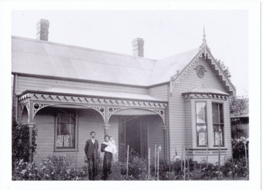
Photograph - Digital image, Curator's or Caretaker's cottage, unknown
This is the original Caretakers or Curators cottage which was built for the first Botanical Gardens curator, George Longley (1858 - 1899) and his family. George and his family, after being made Gardener, moved to the Surveyors Camp where they lived in a tent. Historic significance associated with original Gardens Curatorb/w view of the Caretakers cottage in the Botanical Gardens showing George Longley, Curator (1858 - 1899) with wife and child.b/w, victorian cottage exterior, young family, curator, george longley -
 Emerald Museum & Nobelius Heritage Park
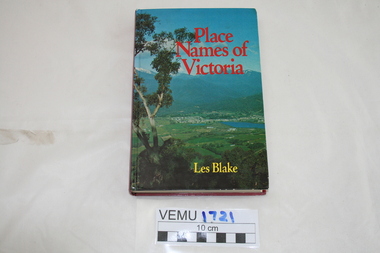
Book, Place Names of Victoria, 1977
The sequence of naming was a chronological representative of land discovery and settlement. Starting from the native population to the explorers, the squatters and settlers and surveyors during the gold rush. The term 'places' refers to physical features of the coast and land as well as districts, towns and cities.Hard Cover book written by Les Blake and first published in 1977. The jacket has a photograph of Mount Beauty and the Kiewa Valley from the Tawonga Gap.place names of victoria -
Clunes Museum
Map - PLAN / MAP
.1 MAP, TOWN OF CLUNES, PARISH OF CLUNES, COUNTY OF TALBOT, STAMPED BOROUGH OF CLUNES .2 PLAN OF SUBDIVISION OF PART OF CLUNES COMMON, BOROUGH OF CLUNES, PARISH OF CLUNES,COUNTY OF TALBOT. P. CAMPBELL. ASSISTANT SURVEYOR, MARCH 1904 ON RIGHT HAND BOTTOM CORNER C71/1 CLUNES COMMON. MARKED: CHARTED R.L.A.7/2/57.1 PHOTO LITHOGRAPHED. DEPARTMENT OF LANDS AND SURVEY, MELBOURNE .2 PHOTO LITHOGRAPHED AT THE DEP. OF LANDS AND SURVEY, MELBOURNE PRICE 1/- 10.11.08map town of clunes, borough of clunes, parish of clunes, county of talbot -
 Whitehorse Historical Society Inc.
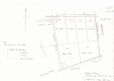
Document, Subdivisions 1859, nd
Sketch map of subdivisions of 1859.Sketch map of subdivisions of 1859. Allotment 126 and portions of 125, 126 and 130, including 'Village of Studley', 'Village of New Brunswick' and two unnamed. Information from Mr McComb, retired surveyor; sketch and notes. Areas near railway line east of Mitcham Station and North East corner of Canterbury and Mitcham Roads. Refer map A - SP 110.Sketch map of subdivisions of 1859.land subdivision, heatherdale road, mitcham, purches street, mitcham road, vermont, canterbury road, whitehorse road, brunswick road, creek road, centre road, studley village, new brunswick village -
 Bendigo Historical Society Inc.
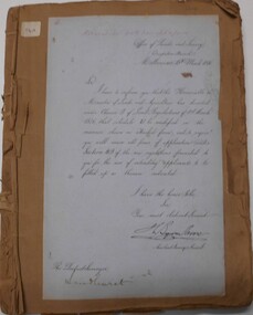
Document - LAND AND SURVEY CIRCULARS 1876 - 1883, 1876 - 1883
Document: land and survey circulars - brown paper covered journal tied with string along spine. On front cover top LH corner '04A' Stuck to front cover is blue foolscap handwritten letter from Office of Lands and Survey (Occupation Branch) Melbourne 15th. March 1876. Journal contains copies of letters signed by District Surveyor, Sandhurst.Office of Lands and Surveyorganization, bendigo, sandhurst, land sales, land surveys -
University of Melbourne, Burnley Campus Archives
Plan, John S. Jenkins, Plan showing land required for Road Purposes from the temporary reservaton for Horticultural Gardens at Richmond, 1880
Plan drawn by hand on tracing paper by John S. Jenkins, Town Surveyor, Richmond. "The land required is coloured red & it is proposed to add the part of Swan Street coloured blue to the gardens." Plan depicts land required for road purposes from the temporary reservation for Horticultural Gardens at Richmond. (Also framed and glazed copy B92.0539.) Scanned on CD.john s. jenkins, gardens, richmond, hoticultural society of victoria -
 Bendigo Historical Society Inc.
Document - MARKS COLLECTION: STRATHFIELDSAYE PLAN 1854
Plan drawn on light paper. Written on LH side of plan 'Plan of Part of the Parish of Strathfieldsaye 1854. Scale (shown) Lithographed at the Surveyor Generals Office, Melbourne July 10th. By I. Jones'. Plan shows Emu Creek and Village Reserve at top of plan, Shepherd's Creek on RH side, Parish Boundary Line on RH and bottom of plan.map, bendigo, shire of strathfieldsaye 1854 -
 Warrnambool and District Historical Society Inc.
Book, Architecture, 1870s
This book belonged to John William Crawley an engineer, architect and surveyor who was appointed District Engineer for the Public Works Department in the Western District in 1866. He was the Shire of Warrnambool Engineer from 1874 to 1895 when he was succeeded by his son. This book is of minor importance as a memento of John William Crawley an important engineer in the Shire of WarrnamboolThis is a hard cover book with pages containing architectural plans,designs and printing. Some of the pages are blank.The cover is faded and spotted and has a gold title The spine is damaged .Inside the front cover is an inscription and on the following page is another inscription.J.W Crawley 1879 Architecture john william crawley, shire of warrnambool -
 Eltham District Historical Society Inc
Document - Survey Plan, Country Roads Board, SP 6800, Eltham-Yarra Glen Road; Bridge St to Henry St, 1958
1958 C.R.B. Plan of Survey of Part of Crown Portions 12 and 13 Section 4 Parish of Nillumbik, County of Evelyn Eltham-Yarra Glen Road., Shire of Eltham Shows Surveyor field notes, property ownership and building type and construction.1958, a.m. gahan, a.s & s.j. davis, annie ellen davies, bridge street, country roads board, d.a. lyon, dave lyon, eltham, flora towell, g.e. gallagher, henry street, j. lyon, k. greene, main road, p.a. gahan, survey plan, w.l. chynoweth pty ltd, york street, neil webster collection -
 Kew Historical Society Inc
Plan - Subdivision Plan, Six Big Home Sites, Camberwell North, c.1936
Subdivision plans are historically important documents used as evidence of the growth of suburbs in Australia. They frequently provide information about when the land was sold on which a built structure was subsequently constructed as well as evidence relating to surveyors and real estate and financial agents. The numerous subdivision plans in the Kew Historical Society's collection represent working documents, ranging from the initial sketches made in planning a subdivision to printed plans on which auctioneers or agents listed the prices for which individual lots were sold. In a number of cases, the reverse of a subdivision plan in the collection includes a photograph of a house that was also for sale by the agent. These photographs provide significant heritage information relating house design and decoration, fencing and household gardens.A subdivision in what is currently Balwyn, but which was advertised as being in Camberwell North. The subdivision included six allotments facing Buchanan Avenue and Houghton Street. The subdivision was to the east of the Pointed Firs Estate (1936). In addition to the intrinsic value of this subdivision plan, it also reveals information about the development of transport infrastructure in this area. The subdivision plan notes that the Tramways Board has approved the extension of the tram route past the current terminus at Balwyn Road.subdivision plans - camberwell -
 Kew Historical Society Inc
Plan - Subdivision Plan, Windella-Darnley Subdivision, Studley Park, 1920s
Subdivision plans are historically important documents used as evidence of the growth of suburbs in Australia. They frequently provide information about when the land was sold on which a built structure was subsequently constructed as well as evidence relating to surveyors and real estate and financial agents. The numerous subdivision plans in the Kew Historical Society's collection represent working documents, ranging from the initial sketches made in planning a subdivision to printed plans on which auctioneers or agents listed the prices for which individual lots were sold. In a number of cases, the reverse of a subdivision plan in the collection includes a photograph of a house that was also for sale by the agent. These photographs provide significant heritage information relating house design and decoration, fencing and household gardens.Version 1 of two subdivision plans (the later one is MAP.0027) for the section of Studley Park Road near the Junction on the south side. Named in the subdivision are the mansions of Darley and Windella (now demolished). Before the subdivision of Darley and Windella, both houses fronted Studley Park Road. Both houses appear to be advertised as lots in the subdivision. Bisecting the subdivision is a street, Antrim Avenue that was never constructed. A street, which was subsequently constructed in this vicinity, was Merrion Place, which now runs between Studley Park Road and Highfield Grove. There are 14 proposed lots in this subdivision."Antrim Avenue. See over for new plan"subdivision plans - kew, studley park, windella, darnley, studley park road -- kew (vic.), merrion place -- kew (vic.), merrion grove -- kew (vic.), highbury grove -- kew (vic.) -
 Kew Historical Society Inc
Plan - Subdivision Plan, Shop Sites, East Kew, c.1927
Subdivision plans are historically important documents used as evidence of the growth of suburbs in Australia. They frequently provide information about when the land was sold on which a built structure was subsequently constructed as well as evidence relating to surveyors and real estate and financial agents. The numerous subdivision plans in the Kew Historical Society's collection represent working documents, ranging from the initial sketches made in planning a subdivision to printed plans on which auctioneers or agents listed the prices for which individual lots were sold. In a number of cases, the reverse of a subdivision plan in the collection includes a photograph of a house that was also for sale by the agent. These photographs provide significant heritage information relating house design and decoration, fencing and household gardens.This is one of a small number of subdivision plans for commercial property in the collection. The subdivision proposed to create six shop sites in High Street between the Harp of Erin and Station Street. The plan shows this stretch of High Street, East Kew already lined with shops that include the hotel on the corner, the new State Savings Bank, a dentist’s surgery and Lambert’s Store. The High Street Tram was to reach Burke Road in 1925, so the proposed subdivision must postdate that event, and the opening of the Bank in 1926.subdivision plans - east kew, high street - east kew -
 Kew Historical Society Inc
Plan - Subdivision Plan, Eastlawn Estate, 1914
Subdivision plans are historically important documents used as evidence of the growth of suburbs in Australia. They frequently provide information about when the land was sold on which a built structure was subsequently constructed as well as evidence relating to surveyors and real estate and financial agents. The numerous subdivision plans in the Kew Historical Society's collection represent working documents, ranging from the initial sketches made in planning a subdivision to printed plans on which auctioneers or agents listed the prices for which individual lots were sold. In a number of cases, the reverse of a subdivision plan in the collection includes a photograph of a house that was also for sale by the agent. These photographs provide significant heritage information relating house design and decoration, fencing and household gardens.The ‘Eastlawn Estate’ was surveyed and ready for auction in March 1914, three months before the outbreak of World War I. Sixty-six allotments, created on the ‘order of Mr & Miss Preston’ surrounded the mansion of Woodlands in Harp Road. Woodlands formed part of the Estate, being advertised as lot 1. The allotments faced High, Station and Wright Streets, Harp and Normanby Roads, and Woodlands Avenue. Pru Sanderson in the Kew Conservation Study (Vol.2, 1988) wrote that the Eastlawn Estate ‘covered the western half of the failed Harp of Erin Estate’. Contemporary advertisements promoted the Eastlawn Estate as: ‘There will be no more convenient district nor pleasant Suburb than East Kew for the busy business man. When the Electric Tram is laid, he will be able to journey quickly and pleasantly direct from Collins Street to his home in the Eastlawn Estate in about 20 minutes’. The actual plans of subdivision were included in advertisements in The Argus and in the local newspapers.subdivision plans - east kew, eastlawn estate -
 Kew Historical Society Inc
Plan - Subdivision Plan, Raheen Estate Subdivision, 1960
Subdivision plans are historically important documents used as evidence of the growth of suburbs in Australia. They frequently provide information about when the land was sold on which a built structure was subsequently constructed as well as evidence relating to surveyors and real estate and financial agents. The numerous subdivision plans in the Kew Historical Society's collection represent working documents, ranging from the initial sketches made in planning a subdivision to printed plans on which auctioneers or agents listed the prices for which individual lots were sold. In a number of cases, the reverse of a subdivision plan in the collection includes a photograph of a house that was also for sale by the agent. These photographs provide significant heritage information relating house design and decoration, fencing and household gardens.The Raheen Estate Subdivision of 1960 involved the creation of 36 residential allotments and the sale of 34 of these. The land on which the subdivision was created had until 1960 formed part of the grounds of the mansion Raheen in Studley Park Road. In 1917, the Catholic Church had purchased Raheen and its lands. It was to become the home of Archbishop of Melbourne, Daniel Mannix, for 46 years. The sale of the subdivision took place three years before the Archbishop’s death. Subsequent archbishops were to reside at Raheen until its sale to the Pratt family in 1981. When the sale of the Estate was reported in the newspapers in 1960, it was described as the last big subdivision near Melbourne. At the auction, 33 of the 36 allotments were sold. The auction realised £315,750. Purchasers were advised that the vendor intended to keep lots 22 and 23. The alllotments in the subdivision required the construction of new roads. These included Eamon Court and Raheen Drive. The justification provided by the Church for the sale was that the estate was being sold to finance school building projects.subdivision plans - kew, studley park, raheen estate, eamon court, studley park road, coombes avenue, raheen drive -
 Kew Historical Society Inc
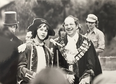
Photograph, Standard Newspapers, Charles Grimes Re-enactment, Yarra River, 1978
The party of the British surveyor Charles Grimes were the first Europeans to view the River Yarra, as it was later to be named. Members of the party reached the area now known as Studley Park in 1803. This local re-enactment commemorated 175 years since that event. Charles Grimes Re-Enactment, Yarra River, Kew, 1978. The photograph is of a student of Trinity Grammar School and the Mayor of Kew, Cr. Whiting. Inscription on reverse: "KH-161. Society's contribution to the 1978 Festival of Kew. Re-enactment of first white man's journey and discovery of the Yarra River and the area now know (sic) as Kew. 1978. This was in the year 1903 when Grimes and party came upon the Yarra to seek a possible site for a new convict settlement. Cr. Whiting, Mayor of Kew, receiving the report from Grimes, 'Andrew Allen'. Cr. Hutchinson in top hat 'town cryer'. Bush band in backround." Ripped stamp on reverse: "Standard N[ewspapers]."charles grimes re-enactment, trinity grammar school, cr whiting -- mayors -- kew (vic.), yarra river, andrew allen, kew historical society -
 Kew Historical Society Inc
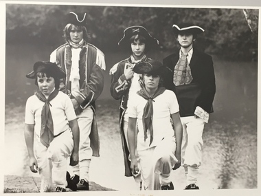
Photograph, Standard Newspapers, Charles Grimes Re-enactment, Yarra River, 1978
The party of the British surveyor Charles Grimes were the first Europeans to view the River Yarra, as it was later to be named. Members of the party reached the area now known as Studley Park in 1803. This local re-enactment commemorated 175 years since that event.Charles Grimes, Re-enactment, Yarra River, Kew, 1978. Inscription on reverse: "Trinity Grammar School students taking part in Grimes' journey up the Yarra, 1803. Re-enactment Historical Society Kew contribution to the 1978 Festival of Kew."charles grimes re-enactment, trinity grammar school, cr whiting -- mayors -- kew (vic.), yarra river, andrew allen, kew historical society -
 Kew Historical Society Inc
Photograph, Standard Newspapers, Charles Grimes Re-enactment, Yarra River, 1978
The party of the British surveyor Charles Grimes were the first Europeans to view the River Yarra, as it was later to be named. Members of the party reached the area now known as Studley Park in 1803. This local re-enactment commemorated 175 years since that event.Charles Grimes, Re-enactment, Yarra River, Kew, 1978. Inscription on reverse: "KH-191. Grimes' party in boat on Yarra 1978. Re-enactment organised by Kew Historical Society. Actors Trinity Grammar boys. Mrs Argyle's History class." Sticker on back: "771. Standard News. WHS. Festival. 4 cols. May 3. [Page] 5."charles grimes re-enactment, yarra river (kew) 1978, cr whiting (mayor of kew), andrew allen, trinity grammar school, kew historical society