Showing 762 items
matching aerial views
-
 Glenelg Shire Council Cultural Collection
Newspaper - Portland Observer Supplement, 2006
... in the community of Portland Aluminium. Glossy coloured covers, aerial... coloured covers, aerial views of smelter on front, smelter staff ...Portland Observer supplement, 2006, celebrating 20 years in the community of Portland Aluminium. Glossy coloured covers, aerial views of smelter on front, smelter staff on back, also on inside of covers. 8 page newspaper insert, history of smelter.portland observer, portland aluminium, alcoa, smelter -
 City of Kingston
Photograph - Colour, c. 1982
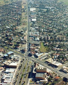
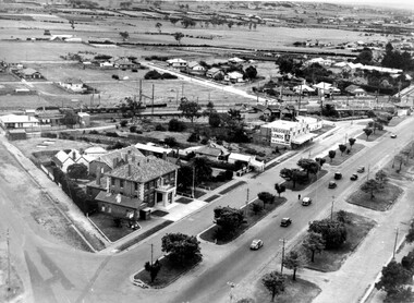
... Colour photograph of an aerial view of South Road.... 7 Colour photograph of an aerial view of South Road ...This aerial photograph of South Road and Nepean Highway, Moorabbin shows the area where houses and shops on the south side of the Nepean Highway have demolished for the widening of the highway. The pressures of rapid urban development in Moorabbin and beyond, especially to the south of Moorabbin caused bottlenecks and delays, especially at the South Road and Nepean Highway intersection, hence the scheme to widen Nepean Highway.The pressures of rapid urban development in terms of people, housing construction, industrial development and commercial activity, in Moorabbin and beyond, especially to the south would put pressure on road infrastructure in the region. In the early 1980s, a major road expansion of the Nepean Highway was implemented to increase capacity on this major thoroughfare for vehicle commuters. Car use had also increased with commuters from the increasingly populous southern suburbs travelling to their place of work in the Melbourne CBD.Colour photograph of an aerial view of South Road and Nepean Highway, Moorabbin. The image shows houses on the south side of the Nepean Highway that have demolished for widening of road. It features housing and commercial buildings looking north towards Cummins Road.Handwritten blue ink: 82 - 5452 - 11 Handwritten red ink: 112% Handwritten black ink: Ch. 7nepean highway, south road, moorabbin, roads, transport, infrastructure -
 University of Melbourne, Burnley Campus Archives
Photograph - Black and white print, Aerial View of Burnley Campus C.1970, c. 1970
... Aerial View of Burnley Campus C.1970...aerial view...Colour photograph of black and white photograph. Aerial...burnley campus aerial view yarra river richmond public golf ...Colour photograph of black and white photograph. Aerial View of Burnley Campus. Enlargement. Shows position of Campus in bend of Yarra River after alterations to the position of the river due to building of Freeway, new ovals and Richmond Public Golf Course.burnley campus, aerial view, yarra river, richmond public golf course -
 Lakes Entrance Regional Historical Society (operating as Lakes Entrance History Centre & Museum)
Photograph, 1980c
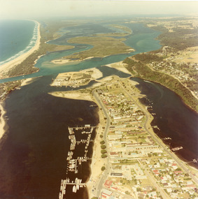
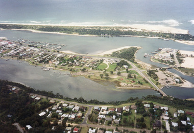
... Colour photograph aerial view of township of Lakes Entrance... photograph aerial view of township of Lakes Entrance, showing western ...Colour photograph aerial view of township of Lakes Entrance, showing western end of town, Bullock Island, Cunninghame Arm and North Arm, man made entrance, and distant view of outer barrier, island and shoreline. Lakes Entrance Victoriawaterways, township, restaurant, bridges -
 Lakes Entrance Regional Historical Society (operating as Lakes Entrance History Centre & Museum)
Photograph, 1975c
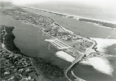
... Black and white photograph of an aerial view of township... and white photograph of an aerial view of township and Kalimna ...Black and white photograph of an aerial view of township and Kalimna Heights, showing the North Arm bridge and boat ramp, sand buildup in the lake system, boat harbour, sand hummocks and beach as far as Red Bluff. Lakes Entrance Victoriaaerial photograph, islands, topography -
 Lakes Entrance Regional Historical Society (operating as Lakes Entrance History Centre & Museum)
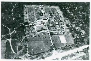
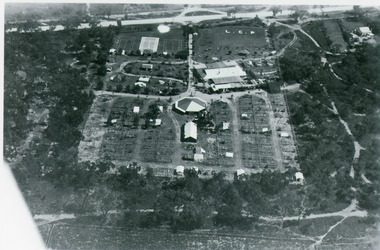
Photograph, Bulmer H D, 1935
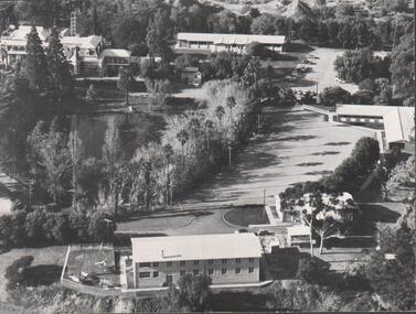
... Black and white aerial view of Whiters Camp Park, looking... aerial view of Whiters Camp Park, looking north from Roadknight ...Black and white aerial view of Whiters Camp Park, looking north from Roadknight Street, showing layout of park including tennis courts, bowling green, picnic area, cottages, rotunda, and the family residence. Lakes Entrance Victoriaguesthouses, tourism, people -
 Bendigo Historical Society Inc.
Photograph - BENDIGO RAILWAY STATION: AERIAL VIEW, 1995
... BENDIGO RAILWAY STATION: AERIAL VIEW...Aerial view of bendigo...Black and white photo: aerial view looking trowards... PLACE Aerial view of bendigo bendigo railway station Peter Hyett ...Black and white photo: aerial view looking trowards Bendigo Railway Station. Mitchell st. runs across lower part of photo. Photo taken prior to building of 'Market place' shopping centre. A 16A black lead on rear.Peter Hyett 1995place, aerial view of bendigo, bendigo railway station -
 Lake Bolac & District Historical Society
Black and white photograph, Aerial View of Lake Bolac, 1947
... Aerial View of Lake Bolac, 1947....Aerial view of Lake Bolac (Boloke) taken in 1947. Fresh... View of Lake Bolac, 1947. Aerial view of Lake Bolac (Boloke ...Aerial view of Lake Bolac (Boloke) taken in 1947. Fresh water lake at bottom left, salt lakes at top right, village at crossroads of north-south Glenelg highway and Ararat-Mortlake road.lake bolac, 1947, glenelg highway -
 Lara RSL Sub Branch
Book, HMAS Mk IV - The RAN's Fourth Book, 1945
... aerials view illustration of Japanese islands with boats... is a green sepia aerials view illustration of Japanese islands ...This is the last of the series of books chronicling the achievements of the ships and personnel of the Royal Australian Navy in WWII. For the whole of the war the Navy was on the job all over the place all of the time. From the first to the last days of WWII RAN was represented, by ships and personnel in the battle for supremacy in t he battle for supremacy at sea. They took part in every rear-guard action in the days when the tide was against. They participated in the invasions of enemy territory that came with the resurgence of Allied strength right through to the final assaults on the Japanese home islands The last book of the series of which HMAS MK IV, servIng personnel of the RAN have recorded the achievements of their service in WWII HMAS Mk IV - The RAN's Fourth Book. Green front, back and spine hardcover.. Inside front and back cover is a green sepia aerials view illustration of Japanese islands with boats and aeroplane. Illustrations, poems, stories, photographs, prints, cartoons.Dedicated to all those past and present, who 'Fear God, Honour the Kingwwii, royal australian navy, triumph of sea power, amphibian, flying seaman, invasion of borneo, whaler's crew, converted ocean liners, wrans go to sea, balikpapan, frigates, new guinea, indonesia, south east oceania, bougainville, surrender of dutch borneo, world war 2 -
 Whitehorse Historical Society Inc.
Photograph, Tally Ho Office Park, 1995
... Aerial view of Tally Ho Office Park on corner of Springvale... Aerial view of Tally Ho Office Park on corner of Springvale Road ...Aerial view of Tally Ho Office Park on corner of Springvale Road & Burwood Highway, East Burwood. Site partly developed. Shows East Burwood Reserve (part) and Bill Sewart Athletics Track. Photo taken facing Burwood Highway.lend lease development pty ltd, tally ho office park, springvale road burwood east, burwood highway burwood east, bill sewart athletic track -
 Falls Creek Historical Society
Poster - Kangaroo Hoppet 2018
... A poster featuring an aerial view of a Hoppet event... the logos: www.hoppet.com.au A poster featuring an aerial view ...The Kangaroo Hoppet is Australia’s premier long distance cross country ski race, and a member of the Worldloppet series of international cross country ski events. The first race at Falls Creek was held in 1979 under the name of “Australian Birkebeiner”. It was a 21km race with about 80 participants organised by the Birkebeiner Nordic Ski Club of Mount Beauty. The course started and finished at Falls Creek Alpine Resort and took participants out into the Bogong High Plains. After running the event for 10 years, it was decided they should become part of the Worldloppet series of marathon ski races. Representatives from the Birkebeiner Nordic Ski Club and the Australian Ski Federation attended the Worldloppet Annual Meeting in Finland in June 1990 to put the case for the acceptance of an Australian event into the Worldloppet series. Before being admitted, they had to demonstrate that the Birkebeiner Club could run a world class event, so three months later in August 1990 a 42km event named the Australian International Ski Marathon was held at Falls Creek together with a 21km Birkebeiner race and a 7km event called the Birkebeiner Lite. The event was approved by delegates from USA, Norway and Austria, in 1991 Australia became the 12th member of Worldloppet, with the condition that there had to be a name change. After some late night discussion allegedly involving red wine from North East Victoria the main event became the 42km Kangaroo Hoppet, with the minor events being the 21km Australian Birkebeiner, and 7km Joey Hoppet. In the winter of 1991, the first Kangaroo Hoppet was held. It was a great success and has been a regular fixture on the international ski calendar ever since. It features the main 42km event as well as a 21km event and a 7km event. The Hoppet brings the Australian snowfields to an international audience. In 2018 the Men's Winner was Valerio Leccardi from Switzerland in a time of 1:39:55. The winner of the Women's event was Barbara Jezersek of Australia in a time of 1:52:59. This poster is significant because it documents an event which brings international attention to Falls Creek and the surrounding region.A poster featuring an aerial view of a Hoppet event with smaller image in diamond shapes on the right. Logos of Worldloppet, AGL, Falls Creek, Alpine Shire Council, Victorian State Government, the Birkebeiner Nordic Ski Club and FIS are across the bottom of the poster. Text: KANGAROO HOPPET 25 August 2018 FALLS CREEK AUSTRALIA 7 km 21 km 42 km Beside the logos: www.hoppet.com.au kangaroo hoppet, worldloppet events, falls creek, mt. beauty -
 Lakes Entrance Regional Historical Society (operating as Lakes Entrance History Centre & Museum)
Photograph, 1997c
... Colour print of aerial view looking south of western side... print of aerial view looking south of western side of township ...Colour print of aerial view looking south of western side of township. Shows housing on Kalimna Hill, North Arm, part of Bullock Island, Cunninghame Arm, the outer barrier and east pier of man made entrance. Lakes Entrance Victoriawaterways, islands, dredging, accommodation -
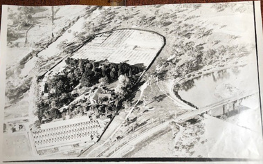
 Bendigo Historical Society Inc.
Photograph - FORTUNA COLLECTION - PHOTOGRAPH
... Black and white photograph, aerial view of part of grounds... Black and white photograph, aerial view of part of grounds ...Black and white photograph, aerial view of part of grounds showing some buildings, partial view of lake and partial view of Fortuna Villa. Writing in pen on back of photo (top left hand side) is an inscription stating 'approx 1962-3'. -
 Bendigo Historical Society Inc.
Photograph - AERIAL VIEW: BENDIGO, 1995
... AERIAL VIEW: BENDIGO...Aerial view of bendigo...Black and white photo: aerial view from St. Paul's church... PLACE Aerial view of bendigo Peter Hyett Black and white photo ...Black and white photo: aerial view from St. Paul's church tower showing Bush's store in foreground. St. Andrew's church middle distance, Myers St. at left front to middle distance. Williamson St. left to right foreground.Peter Hyettplace, aerial view of bendigo -
 Lake Bolac & District Historical Society
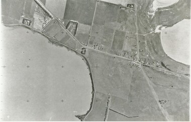
Colour photograph, Lake Bolac Flax Mill, 1960
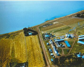
... Aerial view of the Lake Bolac Flax Mill, circa 1960. Note... Mill, 1960. Aerial view of the Lake Bolac Flax Mill, circa 1960 ...Aerial view of the Lake Bolac Flax Mill, circa 1960. Note the pump housing in front of Guy Rance's home, the polluted water entering the lake from the pipeline and the stooks of flax to the left of the road opposite the Mill.lake bolac, flax mill, 1960, rance -
 Whitehorse Historical Society Inc.
Photograph, Aerial View of Australian Tesselated Tile Co. Pty. Ltd. & others, 1935
... Aerial View of Australian Tesselated Tile Co. Pty. Ltd...) of an aerial view of Australian Tesselated Tile Works... Mitcham melbourne Photograph Photograph Aerial View of Australian ...Six black and white photos (three small copies missing) of an aerial view of Australian Tesselated Tile Works.|In the background M & MBW reservoir.|In the foreground is the Builders Trading and Roofing Company Tile works (formerly the Monarch Pottery - note the M on the chimney)australian tesselated tile co.pty ltd, aerial photographs, dams and reservoirs, mitcham reservoir, builders trading and roofing co. ltd, monarch pottery -
 Glenelg Shire Council Cultural Collection
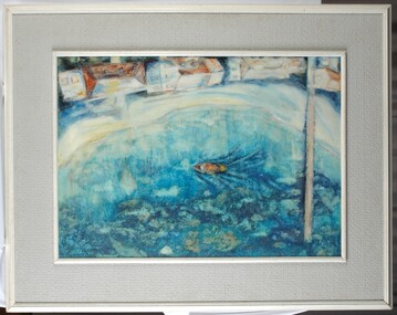
Painting, Summer Holiday, 1967
... Aerial view of a harbour with a jetty and a boat. At edge... Holiday Aerial view of a harbour with a jetty and a boat. At edge ...Aerial view of a harbour with a jetty and a boat. At edge of water is a narrow beach and 4 houses (white with roofs painted in orange, yellow, white and pale blue). Seaweed and reefs are visible below surface of water. Framed in wood and board frame (white and grey).Front: Barnard 1967 (lower left, blue paint). Back: Phyl Barnard "Summer Holiday" 1967. -
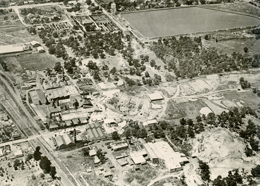
 City of Kingston
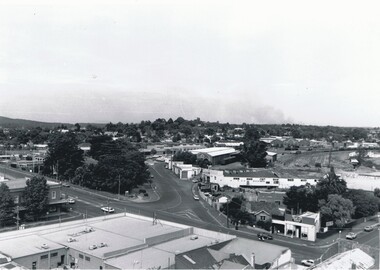
Photograph - Black and white, c. 1930
... Black and white photograph of aerial view of intersection...% / k000786 Black and white photograph of aerial view of intersection ...During the 1930s Moorabbin was an area with open grasslands, still often used for market gardening. The development of the city (and, later, suburb) can be seen emerging from the railway station.The Nepean Highway is a major highway running through the City of Kingston. This image is one of many that depicts its importance to the local community as it undergoes many changes over time.Black and white photograph of aerial view of intersection of Nepean Highway and South Road. Moorabbin Council Chambers are situated on the corner with the library, old shire building, Moorabbin railway station, St David's Anglican Church market gardens and open paddocks in the background.White round sticker on reverse with black printed text: 143 Handwritten in red ink on reverse: 156% / k000786moorabbin, council, railway station, railway, suburbs, paddocks, nepean highway -
 Lakes Entrance Regional Historical Society (operating as Lakes Entrance History Centre & Museum)
Photograph, Bulmer H D, 1935
... Black and white aerial view of Whiters Camp Park, looking... and white aerial view of Whiters Camp Park, looking south ...Black and white aerial view of Whiters Camp Park, looking south to Roadknight Street. Shows layout of camping facilities, including sites, tennis courts, rotunda, and family home which incorporated shop with all requirements for a holiday. Lakes Entrance Victoriatourism, resort, aerial photograph, camping -
 Bendigo Military Museum
Postcard - POSTCARDS WW1, PHOTOGRAPHIC, C.1914 - 1918
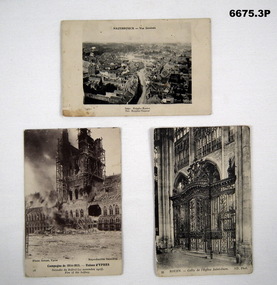
... 1. B & W photo of aerial view town of Hazebrouck at time... of aerial view town of Hazebrouck at time of WW1. 2. B & W photo ...Postcard photos of locations in Northern France relating to Battlefields in WW1.1. B & W photo of aerial view town of Hazebrouck at time of WW1. 2. B & W photo of ruins of Cathedral in Ypres from WW1 called "Fire of the Belfrey". 3. B & W photo of the gate of Saint Oven Church in Rouen Church.1. Headed "Hazebrouck - Vue Generale" - on back is filled in Letter to "Louie". 2. Titled Campagne De 1914-15 - Ruines D' Ypres - Fire of Belfrey. 3. Titled "Rouen - Grille De I'Eglise Saint-Oven (Gate of St Oven Church).passchendaele barracks trust, postcards, france, ww1 -
 Ballarat Tramway Museum
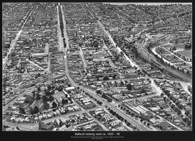
Photograph - Black & White copy, Charles Pratt, "Ballarat looking west ca 1925-40"
... Black & White copy photograph aerial view A4 size, titled... Sturt St victoria St Black & White copy photograph aerial view ...Original photograph by Charles Daniel Pratt, with the original image held by the State Library of Victoria. Edited by Richard Conn. Purchased by the Museum.Provides information about the appearance of Ballarat East and views across over the Railway Station to Lake Wendouree and along along Sturt St. Shows the nature of the Bridge St shopping centre and other places.Black & White copy photograph aerial view A4 size, titled "Ballarat looking west ca 1925-40" - looking along Sturt St with the Railway yards, Bridge St and Victoria St in the view. Some trams can be seen at Grenville St.ballarat, aerial photo, sturt st, victoria st -
 Southern Sherbrooke Historical Society Inc.
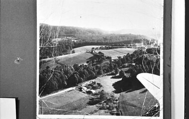
Photograph, Aerial view of Cotswold Valley
... Aerial view of Cotswold Valley...Aerial view of Cotswold Valley, Menzies Creek. B&W photos... Photograph Aerial view of Cotswold Valley Aerial view of Cotswold ...Aerial view of Cotswold Valley, Menzies Creek. B&W photos taken from light plane. Paddocks and treed areas are visible. Two houses are in the centre of the photo, presumably the Breen farmhouse on Jacksons Hill Road. The tip of the plane's left wing is also visible. -
 Queen Victoria Women's Centre
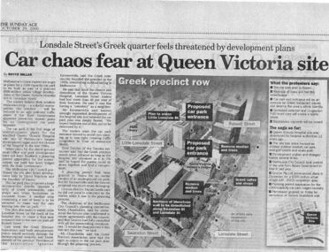
Newspaper excerpt, The Sunday Age, Car Chaos fear at Queen Victoria Site: Lonsdale Street's Greek quarter feels threatened by development plans, 29 October 2000
... . Larger excerpt, a black and white aerial view of QVWC... was to be demolished. Larger excerpt, a black and white aerial view of QVWC ...Newspaper excerpt from The Sunday Age. Page 5 and a smaller introduction probably from the front page. Smaller excerpt colour photo of blue-stone and cast-iron wall which was to be demolished. Larger excerpt, a black and white aerial view of QVWC and the block where it is situated. building construction, building permits, historic building -
 National Vietnam Veterans Museum (NVVM)
Photograph
... A black and white photograph of an oblique aerial view... A black and white photograph of an oblique aerial view ...Denis Gibbons (1937 – 2011) Trained with the Australian Army, before travelling to Vietnam in January 1966, Denis stayed with the 1st Australian Task Force in Nui Dat working as a photographer. For almost five years Gibbons toured with nine Australian infantry battalions, posting compelling war images from within many combat zones before being flown out in late November 1970 after sustaining injuries. The images held within the National Vietnam Veterans Museum make up the Gibbons Collection.A black and white photograph of an oblique aerial view of the Australian Fire Support Base Harrison, Operation Pinnaroo. The FSB provided a battalions direct artillery and mortar support, to the infantry, on operations away from 1st ATF at Nui Dat, Phuoc Tuy Province. (Circa March 1968)photograph, fire support base harrison, operation pinaroo, 1st atf base, nui dat, phuoc tuy province, gibbons collection catalogue, denis gibbons -
 Lakes Entrance Regional Historical Society (operating as Lakes Entrance History Centre & Museum)
Photograph, Bulmer H D, 1940c
... Black and white photograph of aerial view of Kalimna... Black and white photograph of aerial view of Kalimna Heights ...Black and white photograph of aerial view of Kalimna Heights, showing scattered buildings, Princes Highway around side of cliff, western end of township, North Arm bridge, footbridge to Bullock Island, and rock groynes. Track to lookout and signal beacon visible. Lakes Entrance Victoriaboats and boating, jetties, waterways, vegetation -
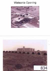 Greensborough Historical Society
Photographs, Watsonia opening; Loyola seminary. Circa 1934, 01/08/1934
... Four photographs and one photocopy. Aerial and ground views..... Aerial and ground views. The Society of Jesus (Jesuits) opened ...The Society of Jesus (Jesuits) opened the seminary in 1934. These photographs were part of the advertising for the opening ceremony. The Jesuit Order had a presence on the site from 1934 to 1974 where a house of formation and studies for the Society of Jesus was located (the current Old Loyola building purchased by the College in 2002). Loyola College Watsonia now occupies the site.1934 photographs showing the site before the residential development in the area.Four photographs and one photocopy. Aerial and ground views.loyola college, jesuits, loyola seminary -
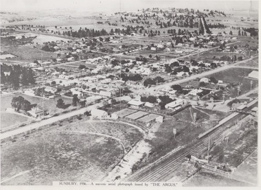 Sunbury Family History and Heritage Society Inc.
Photograph, 1936
... The aerial view of Sunbury was featured in The Argus... AERIAL PHOTOGRAPH ISSUED BY THE ARGUS. The aerial view of Sunbury ...The aerial view of Sunbury was featured in The Argus newspaper in 1936 in recognition of 100 years of European settlement of the area. It shows the extent of the township in 1936 which extended from the railway line in the west to the Jackson Creek in the east and the Sunbury Asylum in the south and northwards towards Macedon Street. The photograph was taken when Sunbury was a country settlement 25 miles ( 37 kms) from Melbourne. Since the 1980s the area grown rapidly and is now an outer suburb of Melbourne.A black and white aerial photograph with a cream border of the Sunbury township. SUNBURY 1936 - A SOUVENIR AERIAL PHOTOGRAPH ISSUED BY THE ARGUS.aerial photographs -
Port Melbourne Historical & Preservation Society
Photograph - Aerial view, The Boulevard Upgrade Sandridge Beach, Oct 2003
... Aerial view...Shows an aerial photographic view of Garden City with five... Street) Port Melbourne melbourne Aerial view Photograph ...Shows an aerial photographic view of Garden City with five smaller pictures of different locations relevant to the upgrade of the boulevard.Existing conditions the Boulevard Upgrade Sandridge Beach 1:500 October 2003 City of Port Phillip.local government - city of port phillip, fred jackson reserve, advertising, perce white reserve, frederick charles jackson, perce mcguire white, perce white -
Port Melbourne Historical & Preservation Society
Photograph, Aerial Survey of Port Melbourne; December 1945, 2105
... photograph mounted on foam board. Shows aerial view of Port... 1945 Large photograph mounted on foam board. Shows aerial view ...Seventeen (17) individual photos were joined together by John Kirby to make a compsite image.Aerial Survey of Port Melbourne; December 1945 Large photograph mounted on foam board. Shows aerial view of Port Melbourne showing its extent from the Bay. Panel on right hand side has key to numbered areas on map . PMHPS logo on top left cornerbuilt environment, local government, natural environment, built environment - industrial, religion - roman catholic church (st josephs), gmh, general motors-holden, rotten row, trotting track, j kitchen & sons pty ltd, wool board storage sheds, government aircraft factory, gaf, commonwealth aircraft corporation, cac, north port oval, brookes lemos ltd, port melbourne fire brigade, former port melbourne market, eclipse theatre, presbyterian church, inner beacon, forsters arms hotel, commonwealth government engine works, st josephs church and school, missions to seamen, centenary bridge, royal australian navy drill hall, mail exchange, gasometers, town pier, robert harper & co ltd, royal australian navy, hmas lonsdale, port melbourne yacht club, pmyc -
 University of Melbourne, Burnley Campus Archives
Photograph - Black and white print, Aerial View of Burnley Campus c. 1930, c. 1934
... Aerial View of Burnley Campus c. 1930...aerial view...Black and white photographs. Aerial Views of Burnley Campus...heyington bridge yarra river aerial view burnley campus ...Black and white photographs. Aerial Views of Burnley Campus. Enlargements. (A) Heyington Bridge to South, Yarra River on North side. (B) Heyington Bridge at top of photograph i.e. reverse view of (A). (C) Original of (B) mounted on board. Probably taken at the time of the floods of 30 November 1934. heyington bridge, yarra river, aerial view, burnley campus, 1934 flood