Showing 1401 items
matching allotments
-
 Ringwood and District Historical Society
Letter, Property for sale - Ringwood Shop and Dwelling Estate, Ringwood, Victoria - circa 1925
ID 5225 note: Further information relating to allotments marked on the hand-drawn plan are included in ID 5224 - Ringwood Station Estate.Typewritten letter from A.V. Greenwood with hand drawn plan of Ringwood Shop and Dwelling Estate, detailed description of property for sale, and top and side elevation views of house. (7 pages)(Transcript of first page - to unknown recipient) Phone 988 Central, 331 Canty Greenwood Pty. Ltd. 5 Flinders Street Melbourne. Dear Sir, 1. Attached please find drawings of my house at Ringwood. 2. It is for sale at £4,865 or to let at £5 per week to an approved tenant. 3. I sold it to Mr. De Garis and vacated it, but it is now back on my hands. 4. I leased another place instead of living in my own. I may be able to cancel same; in the meantime, however, I propose to sell or let my own. The painters are now going through the place; re-varnishing, re-oiling and re-polishing so that in about five days it will look "spick and span". 5. The house was specially built under my own supervision. 6. It is very suitable for a high class Guest House, Doctor's residence, Hospital or Convalescent Home. If you know of anyone whom it might suit, please communicate with them. DESCRIPTION 7. It stands on 305 feet of land facing Greenwood Avenue. It is cement, roughcast and hardwood, well oiled, and is now being redone so that the house is as good as new; red tile roof; verandahs three sides; two sleep-outs; five bedrooms; large dining room; very large music room with nooks, upstairs lounge, study; sewing room; built-in wardrobes and cupboards throughout; handsome kitchen with handsome pantry cupboard with drawers and glass front; one bath room; one shower room; wash house with patent copper and laundry. Every modern convenience, hot water system (through copper pipes with large copper cylinder) electric lights everywhere, outside and in, Yan Yean water laid on everwhere throughout house and gardens. Floors throughout are the very best, close set, stained and polished; dainty lead light windows etc. 8. There is a big garage, with tiled roof and two rooms with all conveniences for a married couple. Property is well drained with a system of its own. The house stands upon the top of a hill close to Railway Station, say 500 feet from the Footbridge. 9. The garden has expansive shrubs; sheds; fernery; tennis court. 10. A handsome piece of furniture goes with the house; a combination pantry and storeroom for groceries, milk, bread etc., consisting of drawers, glass and wire doors, as mentioned above. 11. It is within easy distance of Melbourne as it is only two minutes from Ringwood Station, which is a frequent electric train service bringing it within 39 minutes of the City. It is thought better by some to go further out into the country atmosphere and walk a short distance at the end than to go by train 20 minutes then walk 15 to 20 minutes. 12. The price quoted of £4,865 is made up as follows - 305 feet of land @ £5 ... £1,515 Garage and dwelling ... £300 House hot water system, American cupboard ... £2,600 Water, fencing, sheds & drain ... £250 For the lot ... £4,865 Should you require copies of the enclosed drawings I shall be pleased to supply same. 13. Mr. J.B. McAlpin is the local agent, Phone Ring. 7 (after hours Ring. 44) or you may phone me Central 988. 14. The house is south of the line, facing Greenwood Avenue and immediately at the back of Ringwood House, which is also my property. Yours sincerely, A.V. Greenwood (illegible) ..... (Transcript of second page) RINGWOOD SHOP AND DWELLING ESTATE See these letters on plan attached (H.) Ringwood House and Shops on 100 by 150 feet of land fronting Bedford Road 100 feet @ £10 per foot - £1,000 House and shops - £2,400 ... £3,400 Ringwood House consists of Boarding House, (Phone 101) and two shops, mainly brick; 9 inch walls. Will carry another story. Has music room, dining room, entrance halls, 10 bedrooms, large verandahs, all conveniences, hot and cold water, and stands on what will become a most valuable business corner. (F.)(G.) Mr. Greenwood's house, garage and sheds, stands on 307 feet of land fronting Greenwood Avenue. See detailed description attached ... £4,865 (J.) Cottage on Block 81 in William Street ... £750 (K.) Cottage in Pitt Street ... £650 (Total) £9,665 ..... (Description of third page - Subdivision Plan) Drawn by Edyth Greenwood, phone 988 Central. Subdivision includes Station Street, Pitt Street, Bedford Road, Wantirna Road, James Street, William Street (later Kendall Street), Greenwood Avenue, Ellison Street, and Haig Street. Circles denote blocks for sale. Squares denote house properties for sale. Other features marked include location of businesses along Main Street (Maroondah Highway), cool store, railway station, shop and police station on Bedford Road, church on Station Street, site of schoolmaster's residence and State School, and location of proposed public baths -
 Peterborough History Group
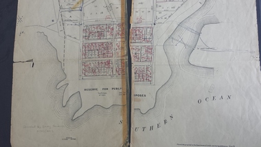
Map - Map of the town, Government Printer, Township of Peterborough
Map donated by Barry Jenkins and assume that updated names were written on the map by him. Good information pertaining to the history of each allotment. Significant as it shows the names of the owners of each allotment in 1931 and handwritten notes of more recent owners.27/6/1931 paper map of the township of Peterborough including names of the landowners at that time.Handwritten landowner names over the original printed names.peterborough, old maps, maps -
 Lakes Entrance Historical Society
Photograph - Kinkuna, 2009
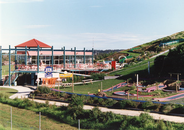
Kinkuna Amusement Park was opened 19 December 1987, closed 2002, building demolished or removed, land sold and subdivided into residential allotments.Copy colour photographic print showing Kinkuna Amusement Park on Princes Highway, owned by Joe and Shirley Walters. Photo shows main building and restaurant, mini golf, long taboggan on hill, garden and other attractions. Lakes Entrance Victoriaentertainment, recreation -
 Bendigo Historical Society Inc.
Document - H. A. & S. R. WILKINSON COLLECTION: CONTRACT OF SALE
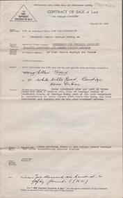
Contract of sale of land dated 20th January, 1956 between Sandhurst & Northern District Trustees Executors& Agency (vendor) and Mrs. M. E. Taylor (purchaser). Property: land being Crown allotment 9 and part of Crown allotment 9A section 55C Parish of Sandhurst city of Bendigo, land described in certificate of title volume 4258 folio 516 land coloured red on the plan endorsed hereon, together with brick dwelling known as 199 Bridge Street, Bendigo. Price: 2,650 Pounds.organization, business, h.a. & s.r wilkinson real estate -
 Bendigo Historical Society Inc.
Document - WES HARRY COLLECTION: SALE OF LAND ALLOTMENT 20 IN TOWNSHIP OF WHITE HILLS DATED 5TH NOVEMBER 1855, 1855
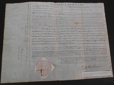
Land Sale Agreement dtaed 5th November 1855 signed and selaed by Charles Hotham Allotment 20 Section 10 Township of White Hills Sold to George Souter Butter for the sum of six pounds and fifteen shillings -
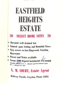 Ringwood and District Historical Society
Flyer, Land Sale Brochure, Eastfield Heights Estate, Croydon. (Undated, circa 1950s)
Bi-fold advertisement for 20 residential allotments with locality map of East Ringwood-Croydon area and map of subdivision bounded by Eastfield Road, and The Pass, Croydon. Agent - N.M. Court, Railway Parade, Croydon, Phone 32093. -
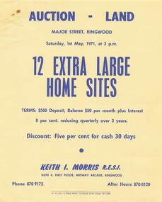 Ringwood and District Historical Society
Flyer - Land Auction, Major Street Ringwood - 1971
Single yellow page with blue print advertising auction of twelve home sites on Saturday 1st May, 1971. Details include vendor terms. Photocopied map of Major Street attached showing layout and dimensions of allotments.Agent: Keith I. Morris R.E.S.I., Suite 4, First Floor, Midway Arcade, Ringwood, Phone 8709175, after hours 8708120. -
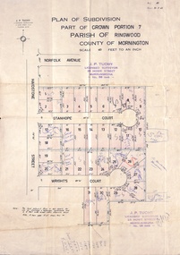 Ringwood and District Historical Society
Document, Plan of Subdivision - Part of Crown Portion 7, Parish of Ringwood, County of Mornington - 1962
Map of residential allotments coloured red, with land coloured blue set apart for drainage & sewerage easements. Rubber stamped J.P. Tuohy, Licensed Surveyor, 25 Howe Street Murrumbeena, Tel. 561945, dated 38.8.1962.Map includes Maidstone Street, Norfolk Avenue, Stanhope Court and Wrights Court, Ringwood, Vic. Also includes handwritten Estate Agent sales notations. -
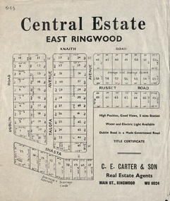 Ringwood and District Historical Society
Flyer, Land Sale Advertisement, Central Estate, East Ringwood - 1948
East Ringwood Central Estate auction sale of allotments previously advertised for Saturday October 23rd (1948). Victorian Collections reference 5138 refers.Single sided leafletSubdivision includes Dublin Road, Knaith Road, Talofa Avenue, Russet Road, and Shasta Avenue. Agent - C.E. Carter & Son, Main Street, Ringwood. WU 6024. -
 The Beechworth Burke Museum Research Collection
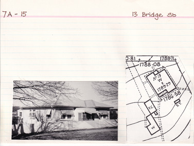
Card (Series) - Index Card, George Tibbits, 13 Bridge Street, Beechworth, 1976
George Tibbits, University of Melbourne. Faculty of Architecture, Building and Town & Regional PlanningIndex system that support the research for Beechworth : historical reconstruction / [by] George Tibbits ... [et al]Arranged by street names of BeechworthEach index card includes: street name and number of property, image of property, allotment and section number, property owners and dates of ownership, description of the property according to rate records, property floor plan with dimensions.beechworth, george tibbitsbeechworth, george tibbits -
 Greensborough Historical Society
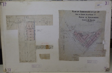
Planning Document, Subdivision Plan # 37. Poulter Avenue and Bicton Street; and, Adeline Street and Grimshaw Street Greensborough, 1971_
Plan of subdivision Lot 29, Part of Crown Allotment, Parish of Keelbundoora, County of Bourke. Poulter Avenue and Bicton Street; and, Adeline Street and Grimshaw Street.An example of hard copy subdivision plans from the Greensborough area. Mainly from the Shire of Diamond Valley era (1964-1994).Plan (2 sheets) mounted on heavy card. subdivision plans, grimshaw street, poulter avenue, adeline street -
 Ringwood and District Historical Society
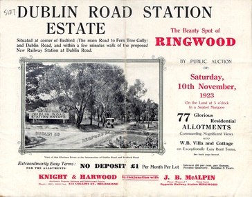
Pamphlet, Land Sale Brochure, Dublin Road Station Estate - 1923
"Extracts from Recent Daily Newspaper - Ringwood Train Service - STATION WANTED AT RINGWOOD EAST. A deputation from the Ringwood East Railway League and Progress Association waited on the chairman of the Railway Commissioners yesterday afternoon and asked that a railway station be erected at Dublin-road, a mile and a quarter from Ringwood. The deputation urged that there were 81 passengers who, if the station were provided, would make daily use of it, and that as the Commissioners had purchased a site for a station at Dublin-road it was evident they had at one time considered it the most suitable site. The Chairman of Commissioners stated that the estimated cost of the station was £3700. Land owners in the locality should pay a proportion of the cost. Members of the deputation replied that there would be no difficulty in raising the money."Multi-fold brochure advertising public auction of residential allotments on Saturday, 10th November, 1923. Brochure includes subdivision features, local facilities and photographic images of the area and details of proposed new railway station at Dublin Road.Subdivision plan includes Dublin Road, Alexandra Road, Vonadawn Avenue, Green Street, Howard Avenue, Wood Street, and Bedford Road (Main Ferntree Gully Road). Auctioneer - Knight & Harwood, 315 Collins Street, Melbourne, Phones Central 10615, 10616. Agent - J.B. McAlpin, Opposite Railway Station, Ringwood, Phone Ringwood 7. -
 Ringwood and District Historical Society
Flyer, Auction Sale Advertisement - Ringwood Station Estate, Ringwood, Victoria - 1919
Folded double-sided brochure advertising auction of residential allotments on Saturday, 11 October, 1919, with town photographs including residence of Mr. and Mrs. Williams on the estate, location map, terms of sale, and summary of local features and services.Subdivision includes Bedford Road and Williams Grove (later Lena Grove). (Agents) Knight & Harwood, 315 Collins Street, Melbourne, Phones Central 10615, 10616, in conjunction with Godbehear & Co., Local Agents, Ringwood, Phone Ringwood 49. -
 Ringwood and District Historical Society
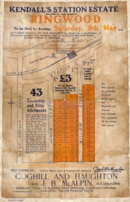
Flyer, Auction Sale Advertisements - Kendall's Station Estate, Ringwood, Victoria - 1914
Advertisements for auction sale on Saturday, 9th May (1914) 43 township and villa allotments directly opposite the railway station, showing terms of sale and subdivision layout. Un-named newspaper clipping advertising this auction also attached.Subdivision includes James Street and William Street (later Kendall Street), Ringwood. Agents in conjunction - Coghill & Haughton and J.B. McAlpin. Sale by order of Mrs. E. Kendall. -
 Bendigo Historical Society Inc.
Document - VICTORIA SURVEY REPORT 1859 TO 60
Four page report presented to both houses of parliament by Surveyor General CH W Ligar dated 1859-60. Object of survey to establish the best method of delineating the boundaries of new allotments in the colony. Geodetic method recommended.bendigo, history, allottment survey -
 Port Melbourne Historical & Preservation Society
Certificate - Title, Crown allotment 2, section 29, Town of Port Melbourne, Office of Titles, Victoria, Jul 1891
Certificate of title relating to Crown allotment 2, Section 29, Town of Port Melbourne, Heath Street. Title in name of Melbourne Permanent Building Society. registered 29th July 1891. title UDL 957, Folio 191304local government - town of port melbourne, town planning, land sales -
Clunes Museum
Document - EXTRACT, CIRCA 1986
PHOTOCOPY EXTRACT FROM VICTORIAN GOVERNMENT GAZETTE PAGE 3973 NO. 86 - 15 OCTOBER 1986 REGARDING VESTING OF LAND IN THE MUNICIPALITY OF THE SHIRE OF TALBOT AND CLUNES. THAT BEING CROWN ALLOTMENT 34, SECTION C, PARISH AND TOWNSHIP OF CLUNESHANDWRITTEN IN PEN: CLU0066-01756 171/86local history, government, state government, shire of talbot and clunes -
 Bacchus Marsh & District Historical Society
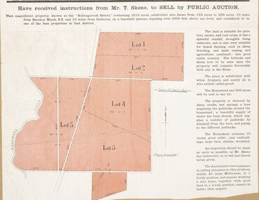
Map, Bullengarook Estate Property Sale. 1911
Bullengarook is a locality located 19 kilometers north of Bacchus Marsh. Pastoral leases for European colonists were granted to people for this area from around the 1840s.The Bullengarook Estate was part of these early pastoral holdings. By the 1900s the property had been owned by the Skene family for a number of years. In early 1911 the property then consisting of 300 acres and the homestead upon it was offered for sale in one lot. It appears however that the sale of the property did not go through in 1911. It was later leased by Thomas Skene to a Mr Coutts in 1915 and ultimately and at a later stage the property was sold by the Skene family.A single page paper map showing land allotments for sale from the Bullengarook Estate. The map is pasted into a bound volume containing 76 maps or plans in total. High resolution digital image stored on BMDHS computer network. land sales bacchus marsh, bullengarook land sales, bullengarook estate, bullengarook vic history -
 Bendigo Historical Society Inc.
Legal record - BERRY Harold Rupert Daniel - Covenant and Indemnity, Watson, James & Rogers, Rogers Collection, 1930
In the early 1980s the firm of Watson, James & Rogers merged with the partnership of Every & Every and became the iconic “Rogers & Every” as known today. The firm is still located on Bull Street. https://rogersevery.com.au/about/Covenant and Indemnity from Mrs A G and Mr M McKenzie to Harold Rupert Daniel Berry concerning Crown Allotment 392, Section H, City of Bendigo Parish of Sandhurst, County of Bendigo. Dated 17 April 1930.Signatureswatson james & rogers, bendigo, legal documents, covenant -
 The Beechworth Burke Museum Research Collection
Card (Series) - Index Card, George Tibbits, William Street, Beechworth, 1976
George Tibbits, University of Melbourne. Faculty of Architecture, Building and Town & Regional PlanningIndex system that support the research for Beechworth : historical reconstruction / [by] George Tibbits ... [et al]Arranged by street names of BeechworthEach index card includes: street name and number of property, image of property, allotment and section number, property owners and dates of ownership, description of the property according to rate records, property floor plan with dimensions.beechworth, george tibbitsbeechworth, george tibbits -
 Ringwood and District Historical Society
Map, Partially Trimmed Copy of Elphin Estate, Ringwood, Vic. - (Undated, circa 1940s)
Clipped subdivision map on cardboard backing.Faint handwritten sales notations on and around numbered allotments in Heywood Street, Maidstone Street and Barkly Street, Ringwood.Surrounding streets also include Lutchie Street (later Sylvia Grove) and incorrect spelling of Barkly Street as Barkley. -
 The Beechworth Burke Museum Research Collection
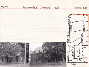
Card - Index Card, George Tibbits, Ford Street, Beechworth, 1976
Property - Methodist Church Hall - Section 5, Town Allotment 5 Ownership details and history Architectural Index Card - Brian Pump and Tony Dugan - Photographers beechworth, george tibbits -
 Kew Historical Society Inc
Plan - Subdivision Plan, Harvest Home Estate, 1919
Pru Sanderson, in her groundbreaking ‘City of Kew Urban Conservation Study : Volume 2 - Development History’ (1988), summarised the periods of urban development and subdivisions of land in Kew. The periods that she identified included 1845-1880, 1880-1893, 1893-1921, 1921-1933, 1933-1943, and Post-War Development. These periods were selected as they represented periods of rapid growth or decline in urban development. An obvious starting point for Sanderson’s groupings involved population growth and the associated economic cycles. These cycles also highlighted urban expansion onto land that was predominantly rural, although in other cases it represented the decline and breakup of large estates. A number of the plans in the Kew Historical Society’s collection can also be found in other collections, such as those of the State Library of Victoria and the Boroondara Library Service. A number are however unique to the collection.The Kew Historical Society collection includes almost 100 subdivision plans pertaining to suburbs of the City of Melbourne. Most of these are of Kew, Kew East or Studley Park, although a smaller number are plans of Camberwell, Deepdene, Balwyn and Hawthorn. It is believed that the majority of the plans were gifted to the Society by persons connected with the real estate firm - J. R. Mathers and McMillan, 136 Cotham Road, Kew. The Plans in the collection are rarely in pristine form, being working plans on which the agent would write notes and record lots sold and the prices of these. The subdivision plans are historically significant examples of the growth of urban Melbourne from the beginning of the 20th Century up until the 1980s. A number of the plans are double-sided and often include a photograph on the reverse. A number of the latter are by noted photographers such as J.E. Barnes.The ‘Harvest Home Estate’ was advertised as being a subdivision in East Kew. Now, Campbell and Owen Streets on which the allotments were located are classed as being in Kew. The Estate included 11 residential allotments abutting the Outer Circle Railway line [at the end of Owen Street]. Understandably, the vendors focused on the availability of transport by tram, noting that the Estate was near the High Street tram terminus at the Harp of Erin. A small note on the subdivision advises that the Cotham Road tram was only 3 minutes away. The location – ‘The most elevated position in lovely Kew’ – was also promoted as an advantage.subdivision plans - east kew, harvest home estate -
 Ringwood and District Historical Society
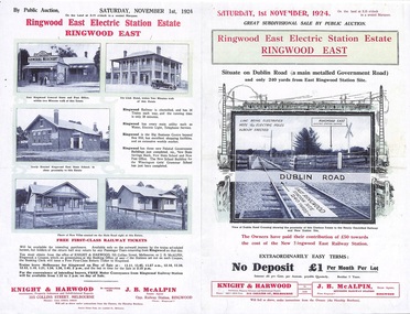
Flyer, Land Sale Auction Brochure, Electric Station Estate, Ringwood East, Vic. - 1924
Folded double-sided advertisement for Ringwood East Electric Station Estate subdivisional sale of retail and residential allotments by public auction on Saturday, 1 November, 1924, with local photographs, terms of sale, and summary of subdivision features and local facilities. Subdivision includes Railway Parade (later Patterson Street, Rosedale Crescent, Federal Road, Howship Avenue (later Howship Court and French Street), and Dublin Road. (Agents) Knight & Harwood, 315 Collins Street, Melbourne, Phone Central 10615, 10616, in conjunction with J.B. McAlpin, Opposite Railway Station, Ringwood, Phone Ringwood 7. -
 Ringwood and District Historical Society
Flyer, Subdivisional Land Auction Sale Brochure, Grand Central Estate, Ringwood, Vic. - 1925
Douglas Street shown in the estate plan did not eventuate, but was developed as a public reserve. Refer also to Reg. No. 5149 for 1924 auction sale of land also titled Grand View Estate situated further north in Ringwood.Double sided multi-folded page advertising public auction sale on Saturday, 31st October, 1925, of residential allotments highlighting local facilities, services and layout of the estate. Includes panoramic view of Ringwood and other local photographic images.Subdivision includes Great Ryrie Street, Heathmont Road, Douglas Street, Garden Street, and Bellevue Avenue. Agents - Knight & Harwood, 315 Collins Street, Melbourne, Phone 10615, 10616 Central, in conjunction with J.B. McAlpin, Opposite Railway Station, Ringwood. Phone Ringwood 7. -
 Bendigo Historical Society Inc.
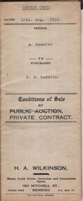
Document - H.A. & S.R. WILKINSON COLLECTION: CONDITION OF SALE
Conditions of sale by private contract dated 12th August, 1932 between A. Cameron (seller) and E.H. Reddick (buyer) for land being allotment 59 section 29A certificate of title volume 3357 folio 671265. Price 430 pounds.organization, business, h.a. & s.r wilkinson real estate -
 Bendigo Historical Society Inc.
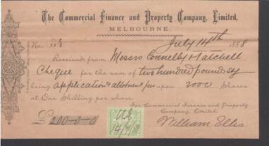
Document - CONNELLY, TATCHELL, DUNLOP COLLECTION: COMMERCIAL FINANCE PROPERTY CO. LTD
Receipt dated 14.7.1888 from Commercial Finance and Property Company Limited, Melbourne to Messrs Connelly & Tatchell, for 200/-/- for application and allotment fees upon 2000 shares. Signed William Ellis green one penny stamp at foot of receiptbusiness, legal, connelly, tatchell collection, connelly, tatchell collection, commercial finance peoperty co. ltd, william ellis -
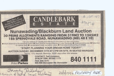 Whitehorse Historical Society Inc.
Document, Candlebark Estate, 27/07/1994 12:00:00 AM
Advertisement of auction of 'Candlebark Estate'.Advertisement of auction of 'Candlebark Estate'. 30 allotments, 186 Springvale Road, Nunawading., 11 December 1994. Agents: Peter Parkes. Former site of 'Winlaton', division of Dept. of Social Welfare. In the Age Property Section 23 November 1994.Advertisement of auction of 'Candlebark Estate'. candlebark estate, nunawading, winlaton, springvale road, land subdivision -
 Lakes Entrance Historical Society
Photograph - Historic House, 1999
Built 1900c, cottage was made available for widow and children of Dougal Egan, lost when fishing boat Orme disappeared in 1909. After Mrs Egan married George South, cottage became known as the South House. Later resident Mrs Edith Rawlinson. Cottage restumped, refurbished 2011 / 2012.|Also Two colour photographs various viewsColour photograph of a timber cottage at 26 Church Street, with both hipped and gable iron roof. Triple sided bay window. Sash windows on west side, with window hoods. Western wall is on boundary of allotment. Lakes Entrance Victoriahouses, heritage study -
 Bacchus Marsh & District Historical Society
Map, Maddingley Township, Parish of Parwan, 1880s
This map is dated Sept. 6th 1856. However places in the township of Maddingley which did not appear until the late 1880s such as the Bacchus Marsh Railway Station and line are shown on this map in their correct locations. This suggests the map has been derived from an earlier map. An earlier date of 1843 with a surveyor's name preceding it can also be seen on the map. The map is important because it indicates the location and dimensions of early but now discontinued use of land such as the showgrounds and police paddock and a site reserved for the Church of England which was not ultimately used for a permanent church. A single page paper map showing land allotments, streets, rivers, creeks, park lands, the railway line and Bacchus Marsh railway station in the township of Maddingley. The map is pasted into a bound volume containing 76 maps or plans in total. Bottom of Map: Surveyor-General's Office, Melbourne, Sept 6th, 1856bacchus marsh victoria maps, maddingley victoria maps, land use, maddingley victoria history