Showing 4999 items matching "bakery"
-
 Surrey Hills Historical Society Collection
Domestic object - Biscuit tin, Mac's Butter Shortbread tin
Mac's Shortbread Co dates its history back to a family bakery in Abbotsford opened in the 1860's producing bread for the goldfields. This eventually became McAlpine's Flour. This business was sold in 1960 and the family then purchased a cake shop, leading to building a biscuit factory. (This is thought to have been the Surrey Hills site). The company outgrew this and moved to Kerang. (Further research required.)This tin is material evidence of the small area of industrial activities that once existed in Surrey Hills.A cylindrical tin with a silvered interior and the outside finished in a white enamel paint, on which are a pattern with 3 butterflies with tartan wings. there is a small printed paper label1. Mac's / MAC'S SHORTBREAD CO. 1 NORFOLK ROAD, SURREY HILLS, VIC. AUST 3127. 836 0333 BUTTER SHORTBREAD INGREDIENTS WHEAT FLOUR, CHOICE BUTTER, SUGAR< EVAPORATED MILK, BAKING POWDER 300g NETbakeries, surrey hills, mac's shortbread, norfolk road -
Surrey Hills Historical Society Collection
Container - Biscuit tin, Mac's Butter Shortbread tin
Mac's Shortbread Co dates its history back to a family bakery in Abbotsford opened in the 1860's producing bread for the goldfields. This eventually became McAlpine's Flour. This business was sold in 1960 and the family then purchased a cake shop, leading to building a biscuit factory. (This is thought to have been the Surrey Hills site). The company outgrew this and moved to Kerang. (Further research required.)This tin is material evidence of the small area of industrial activities that once existed in Surrey Hills.A cylindrical tin with a silvered interior and the outside finished in a white enamel paint, on which are a pattern of gold lions and tartan structures1. Mac's / BUTTER SHORTBREAD 300g NET./ PRODUCT OF AUSTRALIA MADE BY MAC'S SHORTBREAD CO., 1 NORFOLK ROAD, SURREY HILLS, VICTORA INGREDIENTS WHEAT FLOUR, CHOICE BUTTER, SUGAR, LEAVENING, YOLKINE / Bar code 9 310034 305318bakeries, surrey hills, mac's shortbread, norfolk road -
 Surrey Hills Historical Society Collection
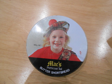
Container - Biscuit tin, Mac's Petticoat Tail Butter Shortbread tin
Mac's Shortbread Co dates its history back to a family bakery in Abbotsford opened in the 1860's producing bread for the goldfields. This eventually became McAlpine's Flour. This business was sold in 1960 and the family then purchased a cake shop, leading to building a biscuit factory. (This is thought to have been the Surrey Hills site). The company outgrew this and moved to Kerang. (Further research required.)This tin is material evidence of the small area of industrial activities that once existed in Surrey Hills.A round tin with a silvered interior and the outside finished in a white enamel paint with the head and shoulders of a blond girl in red jumper, tartan sash and brooch and a tartan tam o'shanter hat.1. Mac's / Petticoat Tail BUTTER SHORTBREAD 450g NET./ BAKED IN AUSTRALIA BY MAC"S SHORTBREAD CO., 1 NORFOLK ROAD, SURREY HILLS, VICTORA AUSTRALIA PHONE 8360333 INGREDIENTS WHEAT FLOUR, CHOICE BUTTER, SUGAR, EVAPORATED MILK BAKING POWDERbakeries, surrey hills, mac's shortbread, norfolk road -
 Tarnagulla History Archive
Photograph: Debris after flood, Newbridge, Debris after flood, Newbridge, 1909 (original image)
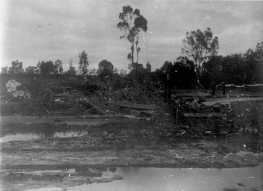
On 20th August, 1909 the Laanecoorie Weir broke away and released 18.3 million cubic metres of water through the opening and causing severe damage to all towns downstream. At Newbridge, Petersen's bakery collapsed and Simpson's Store and Hotel flooded to the roof. The billiard table was later found in a tree five miles down the Loddon near Learmonth. Murray Comrie Collection. Monochrome photograph, image depicting debris in the area near Loddon River at Newbridge after major flood in 1909. This is a very dark copy of an older original. Copy probably made by Murray Comrie in the 1960s.newbridge, loddon river, flood -
 Tarnagulla History Archive
Photographs: Loddon River, Newbridge after flood, Loddon River, Newbridge after flood, 1909 (original image)
On 20th August,1909 the Laanecoorie Weir broke away and released 18.3 million cubic metres of water through the opening and causing severe damage to all towns downstream. At Newbridge, Petersen's bakery collapsed and Simpson's Store and Hotel flooded to the roof. The billiard table was later found in a tree five miles down the Loddon near Learmonth. Murray Comrie Collection. Two copies of a monochrome photograph, image part of damaged bridge in the area near Loddon River at Newbridge after major flood in 1909. This is a very grainy and dark copy of an older original. Copy probably made by Murray Comrie in the 1960s.newbridge, loddon river, flood, bridge -
 Tarnagulla History Archive
Photographs: Loddon River, Newbridge after flood, Loddon River, Newbridge after flood, 1909 (original image)
On 20th August,1909 the Laanecoorie Weir broke away and released 18.3 million cubic metres of water through the opening and causing severe damage to all towns downstream. At Newbridge, Petersen's bakery collapsed and Simpson's Store and Hotel flooded to the roof. The billiard table was later found in a tree five miles down the Loddon near Learmonth. Murray Comrie Collection. Two copies of a monochrome photograph, image depicts the area near Loddon River at Newbridge after major flood in 1909. This is a very grainy and dark copy of an older original. Copy probably made by Murray Comrie in the 1960s.newbridge, loddon river, flood, bridge -
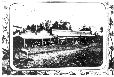
 Linton and District Historical Society Inc
Photograph, Taylors Super Snaps Ballarat, Sussex Street, Linton
Photograph taken from high vantage point further along Sussex Street. Visible east side: Edinburgh Bakery, Preston's shop, Wishart's blacksmiths. Church of England vicarage in the distance. Visible west side: roofs of Morgan's and Sandow's stores. The photograph is undated but thought to have been taken in the 1940s, as there are electricity poles in the street. (Electricity came to Linton in 1939).Very small photograph of Sussex Stret, Linton, view to south-east.sussex street linton -
 Ballarat Tramway Museum
Photograph - Black & White Photograph/s, 1955 or 1956
Black and white photograph of two Geelong bogie trams at the intersection of Moorabool and Ryrie Streets and Pengelly tram No. 17 turning into Moorabool St. See Reg. Item 2798 for a photograph just taken prior to this one. Tram No. 33 in Moorabool St. has the destination of Belmont, while the adjacent tram has the destination of North. The third tram is eastbound in Ryrie St. Note Safety zone signs, the bar traffic lights. In the background is Kays bakery. tramways, trams, geelong, moorabool st, ryrie st, traffic lights, safety zone, tram 33, tram 17 -
 Rutherglen Historical Society
Photograph - Image, R. Cuilleremot, Boespflug et Cie, 1914-1918
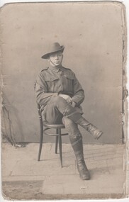
Soldier has been identified as PTE Alan George William Hooke (11513). Alan was a Baker by trade. His father was William Hugh Hooke and his mother was Margaret Holloway Hooke. Alan was born in Rutherglen in 1893 and died in Melbourne in 1978. He is the older brother of Norman Hooke who was KIA in France 1916. Alan belonged to 3rd Field Bakery Unit, AIF.Black and white portrait photograph, on a postcard, of Alan George Hooke in AIF uniformWritten on back: "Alan"world war 1, world war i, alan hooke -
 Ballarat Tramway Museum
Slide - 35mm slide/s, Travis Jeffrey, late 1960's
Agfa plastic mount (blue base, white cover) of a photograph of No. 28 Lydiard St North entering Gregory St loop. Photographed from a car. Destination has not been changed from Lydiard St. Nth. Photo taken late 1960's. "Local Maid Bakery" on the right hand side of the photograph. Slide rescanned at 3200 dpi 25-10-2020, jpg replaced, tiff file retained. This file was scanned in 2003 and may show colour changes."BAS 46" in penciltramways, trams, gregory st, lydiard st nth, tram 28 -
 Eltham District Historical Society Inc
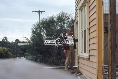
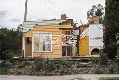
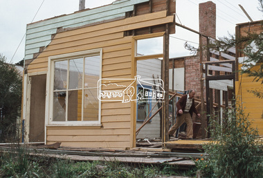
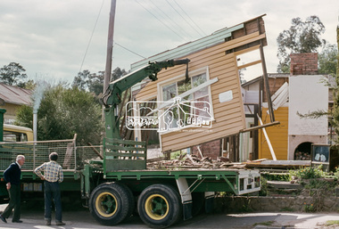
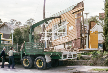
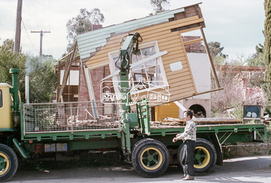
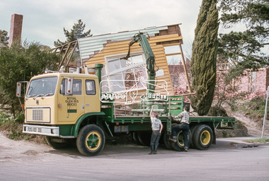
Slide, Joh Ebeli, Preserving parts of the old Baker's house, corner of York Street and Main Road, Eltham, c.Sep. 1979
The old weatherboard building, possibly dating from the 1860s, comprised a dwelling with a shop in the front room opening off a timber verandah deck which directly fronted the Main Road footpath. At the rear is a brick building of much later date which was for many years used for the bakery. The buildings were demolished for flat construction. Joh Ebeli and Elwers Howard endeavoured to preserve some parts of the house.35 mm colour positive transparency Mount - Agfachrome Professional black (Germany) 4 dotsmain road, old eltham bakery, york street -
 Eltham District Historical Society Inc
Slide, Joh Ebeli, Preserving parts of the old Baker's house, corner of York Street and Main Road, Eltham, c.Sep. 1979
The old weatherboard building, possibly dating from the 1860s, comprised a dwelling with a shop in the front room opening off a timber verandah deck which directly fronted the Main Road footpath. At the rear is a brick building of much later date which was for many years used for the bakery. The buildings were demolished for flat construction. Joh Ebeli and Elwers Howard endeavoured to preserve some parts of the house.35 mm colour positive transparency Mount - Agfachrome Professional black (Germany) 4 dotsmain road, old eltham bakery, york street -
 Greensborough Historical Society
Photograph - Digital Image, Marilyn Smith, Old Mernda Market 2018, 27/09/2018
In 2018 GHS members visited Turner's Bakery in Mernda for lunch and continued on to visit historic sites remaining in the Mernda area. This photograph shows remnants of the Mernda Market, established in 1919 as a livestock market. It was sited on Plenty Road in the carpark of the Bridge Inn Hotel. It evolved into a weekend 'trash and treasure' market although livestock auctions still took place on Mondays. In 2012 the livestock auctions moved to Whittlesea Showgrounds.Mernda is an area of rapid modern growth with a few remaining historic buildings dating from the 19th century.Digital copy of colour photographsmernda, mernda historic sites, mernda market, plenty road mernda, livestock auctions, trash and treasure markets -
 Orbost & District Historical Society
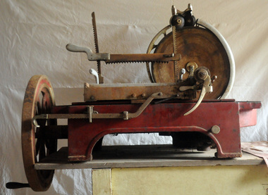
meat slicer, Early 20th century
This item was used in Dicken's Store. Originally the Pardew Brothers store in Nicholson Street, Orbost, Frank Dicken purchased the shop business. It was a bakery and general store and was known as F.B. Dicken and Son. In 1948 they bought the shop freehold . The store remains today converted into two separate shops. The meat slicer was purchased from Henry Berry and Company a large wholesale grocers and general merchant company, first established in Melbourne in 1859.The Dicken store is a prominent Orbost building. Frank and May Dicken moved to Orbost in 1936 where Frank became manager of Pardew Brothers store in Nicholson Street. In 1945, Frank purchased the business and in 1947, formed a partnership with his son, Selwyn. The store was then called F.B. Dicken and Son. The premises are still retained by the Dicken family although the shop business was sold in 1981. (ref. In Times Gone By - Deborah Hall)A heavy commercial meat slicer which sits on bench. Frame is painted red. The tray moves as the handle turns. The main structure is cast iron. It has a circular steel blade. The chrome output tray is detachable. The movable carriage has a cast aluminium tray with spikes to hold the meat and there is an adjustable clamp to secure the meat.INVICTA Model No 302 21 HENRY BERRY PTY LTD MELBfood-preparation dicken-store meat-slicer -
 Eltham District Historical Society Inc
Slide, Construction of Eltham Town Park, 25 Jul 1973
Construction of Eltham Town Park; landscape has been scupltured and lakes formed. View looking up towards intersection of Bridge Street with Main Road. On the high side of Main Road is Garni Burges former home at the corner of Bridge Street then further to the left the former bakery on the corner of York Street. On the opposite corner is the feed store now the site of Le Pine Funerals. The park was later renamed Alistair Knox Park.35 mm colour positive transparency Mount - Agfacolor Service (Blue)Memorial Park 25 July 1973eltham, main road, alistair knox park, eltham town park, shillinglaw cottage, bridge street -
Glen Eira Historical Society
Article - PATERSON’S CAKES
This file contains one item about Paterson’s Cakes, a bakery formerly located on 332 Centre Road, Bentleigh and 117 Chapel Street, Windsor: 1/A clipping from an article from the Leader newspaper (titled ‘Peter Schneider’, by Tempe Bamford, dated 06/2010) about the closure of the business, in which its owner and head pastry chef, Peter Schneider, is interviewed by ’MW’ about its history and why he is closing it.paterson’s cakes, bakeries, bakers, shops, local history, schneider peter, paterson lavinia, stauber jean, schneider walter, bamford tempe, centre road, bentleigh -
 Federation University Historical Collection
Map, Municipality of Ballarat East, 1857
Gold was discovered in Ballarat in 1851. This plan was created six years later and names some of the great gold locations of Ballarat East. It also shows the locality of the Eureka Stockade (1854) and the walking tracks and roads on the Ballarat East Goldfield.In 2007 this map was listed on the inaugural Ballarat Treasure's Register.Large map backed onto linen. The map has read and blue highlights, and identifies areas such as Mount Pleasant, Golden Point, White Flat, Nightingale, Malekoff, Old Post Office Hill, Red streak, Gumtree Flat, Old Gravelpits, Bakery Hill, Ballaarat Flat, The Camp, Specimen Gully, Pennyweight Hill, Warrenheip Gully, Gays Gully, Pennyweight Flat, Eureka, Black Hill, Pinchgut, Crocodile, Hit or Miss, Little Bendigo, Brown Hill, Mopoke, Cricket Reserve, Canadian Hotel, Ballarat Eastmount pleasant, golden point, white flat, nightingale, malekoff, old post office hill, red streak, gumtree flat, old gravelpits, bakery hill, ballaarat flat, the camp, specimen gully, pennyweight hill, warrenheip gully, gays gully, pennyweight flat, eureka, black hill, pinchgut, crocodile, hit or miss, little bendigo, brown hill, mopoke, cricket reserve, canadian hotel, ballarat eastm phillips, john phillips, field draughtsman, ballarat east, ballarat east map -
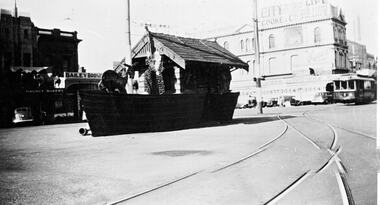 Ballarat Tramway Museum
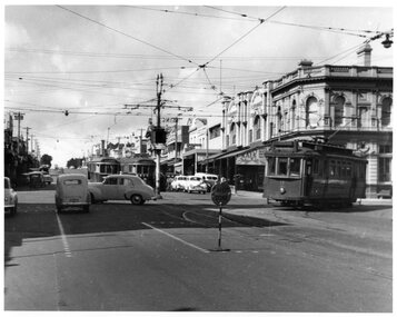
Photograph - Digital image, W. J. Llewelyn, 1939
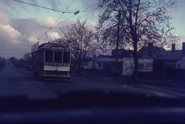
Digital image of the Grenville St tram shelter decorated for the Victorian Centenary celebrations in Ballarat 1938 - the shelter has been decorated to look like a boat. Has tram 18 or 19 entering Bridge St. In the background is Bailey Bros butcher, Magnet bakery, advert for city Life Mutual and Cooke & Co. finance on the Nicholl & Allan building, Grenville St., Bridge St Photo by Jane Holmes, from the Museum of Victoria website - see related documents. Note the scanning error in the trackwork.trams, tramways, centenary, ballarat, shelters, grenville st, tram 18, tram 19 -
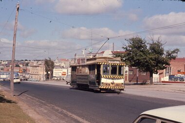 Ballarat Tramway Museum
Slide - 35mm slide/s, Chas Bevan, 19/12/1970 12:00:00 AM
Yields information about the Bakery Hill / Victoria St hill area.Colour slide - 35mm - of Ballarat single trucker 31, about to descend the Bakery Hill in Victoria St, inbound. Tram has the destination of Gardens via Sturt St West. Has the Stones Corner building in the background, Mack Hotel and an advertisement for Beaurepaires tyres. Tram 31 has an a Twin Lakes advertisement and Bliss Bombs (To read pack: Tilt Tram) roof advertisement. Photo taken by Chas Bevan on Saturday 19-12-1970. Note the change since the roundabout for Humffray St was built."Ballarat trams ? Highway. East 19-12-70 - Myers Xmas"tramways, trams, victoria st, bakery hill, stones corner, humffray st, tram 14, tram 17 -
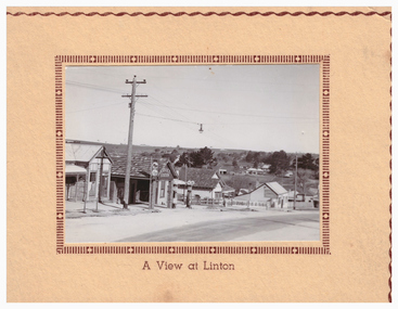 Linton and District Historical Society Inc
Postcard, A View at Linton, Sussex Street, Linton, view to south-east, circa 1940
A very small photograph which has been made into a souvenir/postcard. The photograph is a view of Sussex Street, Linton, looking to the south-east. Buildings which can be seen in the photograph include Bennett's garage/service station, the Bennett family home, and the Edinburgh Bakery. The photograph is glued to a cream-coloured card which has a decorative edge cut into it. A printed border surrounds the photograph, and the words "A View at Linton" are printed underneath it. The card appears to have had the left-hand edge trimmed with scissors.sussex street linton, buildings, shops, houses, bennett's garage, bennett family home, edinburgh bakery, postcards, souvenirs -
 Tarnagulla History Archive
Photograph: Simpsons Store and Hotel, Newbridge after flood, Simpsons Store and Hotel, Newbridge after flood, 1909 (original image)
In this image, store merchandise, including drapery, is hung out to dry after the flood. On 20th August,1909 the Laanecoorie Weir broke away and released 18.3 million cubic metres of water through the opening and causing severe damage to all towns downstream. At Newbridge, Petersen's bakery collapsed and Simpson's Store and Hotel flooded to the roof. The billiard table was later found in a tree five miles down the Loddon near Learmonth. Murray Comrie Collection. Monochrome photograph, image depicting buildings in the area near Loddon River at Newbridge after major flood in 1909. This is a very grainy and dark copy of an older original. Copy probably made by Murray Comrie in the 1960s.newbridge, loddon river, flood, simpson, stores, hotels -
 Glen Eira Historical Society
Album - Album page, Kambrook Road, Circa 1972
This page of photographs is part of the Caulfield Historical Album 1972. This album was created in approximately 1972 as part of a project by the Caulfield Historical Society to assist in identifying buildings worthy of preservation. The album is related to a Survey the Caulfield Historical Society developed in collaboration with the National Trust of Australia (Victoria) and Caulfield City Council to identify historic buildings within the City of Caulfield that warranted the protection of a National Trust Classification. Principal photographer thought to be Trevor Hart, member of Caulfield Historical Society. Most photographs were taken between 1966-1972 with a small number of photographs being older and from unknown sources. All photographs are black and white except where stated, with 386 photographs over 198 pages. First 2 images: milkbar and residence corner Kambrook and Balaclava Roads ie south west corner - building named Airdrie 3rd image: https://vhd.heritagecouncil.vic.gov.au/places/43737 - re 26 Kambrook Road and 345 Balaclava Road corner building ie south east corner: A prominently situated two-storeyed complex of late Victorian buildings consisting of "Wybar's Buildings" occupying the Balaclava Road/ Kambrook Road corner and the "Caulfield Bakery" facing Kambrook Road, separated by a driveway from a single storeyed shop. The main building has a comer splay and balustraded parapet with curved pediments, the words "Wybar's Buildings 1887" having been obliterated but "Caulfield Bakery 1887" with the characteristic wheatsheaf surviving in raised cement work. The walls are stuccoed and richly ornamented with bracketed cornices and keystones with masks extending to the Bakery. The main building is further distinguished by the Masonic symbol of the mason's dividers in the pediment whilst the upper level of the bakery is in overpainted brickwork. The single storeyed shop incorporates the bracketed cornice and consoles characteristic of the main buildings and is in other respects a utilitarian structure. 4th image: https://vhd.heritagecouncil.vic.gov.au/places/42415 (on 24/01/2021) - 196 Kambrook Road An imposing late Victorian poly-chrome brick asymmetrical villa with corner verandah and projecting west facing wing with faceted window bay to the facade. Body bricks are red and relieved by cream and black brick banding and by cream bricks to the bracketed eaves. The fretted barge with king post treatment and timber posted verandah are unique in the Municipality and unusual in the metropolitan area and demonstrate an understated appreciation of the emerging Queen Anne mode.345 Balaclava and 26 Kambrook Roads HO91 - City of Glen Eira https://vhd.heritagecouncil.vic.gov.au/places/43737 (on 24/01/2021) "Wybar's Buildings" at the corner of Balaclava Road and Kambrook Road are important as a prominent late Victorian commercial development incorporating a variety of activities including a bakery and possibly a coffee palace, the latter understood to be unique within the municipality, but characteristic of the period. It is a rare complex of its type in Caulfield and is important also as evocative evidence of the late Victorian Land Boom and the creation of a small now defunct commercial centre at this location by the George Wybrow. 196 Kambrook Road HO122 - City of Glen Eira https://vhd.heritagecouncil.vic.gov.au/places/42415 "Glencoe" is situated at no. 196 Kambrook Road, Caulfield North and was built for the boot manufacturer, Robert Bruce Mair, in 1888. It is of historic and aesthetic significance. It is historically significant (Criterion A) as the home of an inner suburban industrialist, notable a boot manufacturer, demonstrating the attraction of Caulfield as a residential location for the manufacturers of the metropolis during the late Victorian Boom period. It is aesthetically significant (Criterion E) as a very early example of a Queen Anne influenced late Victorian villa, comparing at the State level with ''Woodlands'' (1888), North Essendon, generally acknowledged to be one of Australia's earliest houses to fully exploit this emerging style. The ornamental timberwork is especially expressive of the new architectural fashion and compares with the house at 33 Clarence Street, Elsternwick (1888-89).Page 105 of Photograph Album with two photographs of a milk bar and attached residence, one older photograph of Wybar's Building and another photograph of a house on Kambrook Road (all are landscape).Handwritten: 196 KAMBROOK ROAD / 1970 - GAFFNEY MRS S.M. [under bottom right photo] / 100 [bottom left]trevor hart, kambrook road, victorian style, caulfield north, parapets, wybar's buildings 1887, caulfield bakery 1887, architectural features, painted bricks, balaclava road, george wybrow, shops, milk bars, airdrie, polychrome bricks, verandahs, queen anne architectural style, houses, glencoe, robert mair -
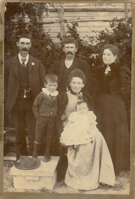 Ballaarat Mechanics' Institute (BMI Ballarat)
Brogden family
This photograph is held in the Ballaarat Mechanics' Institute Audio Visual Collection. Please contact BMI for all print and usage inquiries. Left to Right John Brogden, David Brogden, Rosina Hayes George age 4, Harriet Brogden (nee Hayes), John Brogden 4 months John Brogden was born 1864 and lived at 9 Lal Lal Street Ballarat East Joan and George Brogden (born 1894) ran Bakery 1922-1966 which became Sunnycrust ballarat, brogden, family, 1880s