Showing 749 items
matching contractor
-
 Bendigo Historical Society Inc.
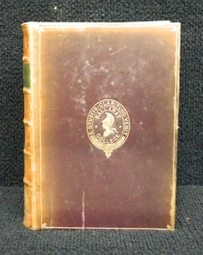
Document - The Reynolds Family Records Collection (Folder 2 of 4) Eleanor Hinde, Abt 2005
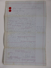
Eleanor Hinde (1842-1902) was born in Lancashire England. In 1858, Eleanor married Richard Reynold in the Forest St Wesleyn Methodist Church in Sandhurst. They both gave their address as Sailors Gully Goldfields. They had seven children together. Richard was a skilled tradesman and after he died in 1872 from lung disease, Eleanor married Arculus Opie. Eleanor owned a property on the corner of Gladstone and Stanley Streets which later became an electrical substation. She sold poultry and eggs and preserves. One of Eleanor's sons, William John, married Anna (Annie) Jorgensen, and one of her daughters. Amelia, married Anna's brother Thomas Joynes Jorgensen. The Jorgensens founded and managed Jorgensen and Sons foundry and engineering works. Peter Jorgensen (1849-1914), was a mining contractor, he lived at, "Bro," Russell street, Quarry Hill. His firm was Jorgensen and Sons, mining contractors. He was a native of the Island of Alsen, Denmark. He left Denmark in the year 1861, embarking at Hamburg in a small sailing Ship. The four folders contain family history documents and photos of the descendants of Eleanor Hinde. Notes on Eleanor Hindebendigo, sandhurst, peter jorgensen, eleanor hinde, eleanor reynolds, eleanor opie, reynolds collection, richard reynolds and eleanor hinde -
Bendigo Historical Society Inc.
Document - The Reynolds Family Records Collection (Folder 2 of 4) William John Reynolds, Abt 2005
Eleanor Hinde (1842-1902) was born in Lancashire England. In 1858, Eleanor married Richard Reynold in the Forest St Wesleyn Methodist Church in Sandhurst. They both gave their address as Sailors Gully Goldfields. They had seven children together. Richard was a skilled tradesman and after he died in 1872 from lung disease, Eleanor married Arculus Opie. Eleanor owned a property on the corner of Gladstone and Stanley Streets which later became an electrical substation. She sold poultry and eggs and preserves. One of Eleanor's sons, William John, married Anna (Annie) Jorgensen, and one of her daughters. Amelia, married Anna's brother Thomas Joynes Jorgensen. The Jorgensens founded and managed Jorgensen and Sons foundry and engineering works. Peter Jorgensen (1849-1914), was a mining contractor, he lived at, "Bro," Russell street, Quarry Hill. His firm was Jorgensen and Sons, mining contractors. He was a native of the Island of Alsen, Denmark. He left Denmark in the year 1861, embarking at Hamburg in a small sailing Ship. The four folders contain family history documents and photos of the descendants of Eleanor Hinde. Notes on William John Reynolds and Anne Dorothea Jorgensen - Contact the Society for detailsbendigo, sandhurst, peter jorgensen, eleanor hinde, eleanor reynolds, eleanor opie, reynolds collection, william john reynolds and anne dorothea jorgensen -
Bendigo Historical Society Inc.
Document - The Reynolds Family Records Collection (Folder 2 of 4) Richard Reynolds, Abt 2005
Eleanor Hinde (1842-1902) was born in Lancashire England. In 1858, Eleanor married Richard Reynold in the Forest St Wesleyn Methodist Church in Sandhurst. They both gave their address as Sailors Gully Goldfields. They had seven children together. Richard was a skilled tradesman and after he died in 1872 from lung disease, Eleanor married Arculus Opie. Eleanor owned a property on the corner of Gladstone and Stanley Streets which later became an electrical substation. She sold poultry and eggs and preserves. One of Eleanor's sons, William John, married Anna (Annie) Jorgensen, and one of her daughters. Amelia, married Anna's brother Thomas Joynes Jorgensen. The Jorgensens founded and managed Jorgensen and Sons foundry and engineering works. Peter Jorgensen (1849-1914), was a mining contractor, he lived at, "Bro," Russell street, Quarry Hill. His firm was Jorgensen and Sons, mining contractors. He was a native of the Island of Alsen, Denmark. He left Denmark in the year 1861, embarking at Hamburg in a small sailing Ship. The four folders contain family history documents and photos of the descendants of Eleanor Hinde. Notes on Richard Reynolds - updated Jan 2005 by Ruth Pendavinghbendigo, sandhurst, peter jorgensen, eleanor hinde, eleanor reynolds, eleanor opie, reynolds collection, richard reynolds -
Bendigo Historical Society Inc.
Document - The Reynolds Family Records Collection (Folder 2 of 4) Raymond Gifford Reynolds, Abt 2005
Eleanor Hinde (1842-1902) was born in Lancashire England. In 1858, Eleanor married Richard Reynold in the Forest St Wesleyn Methodist Church in Sandhurst. They both gave their address as Sailors Gully Goldfields. They had seven children together. Richard was a skilled tradesman and after he died in 1872 from lung disease, Eleanor married Arculus Opie. Eleanor owned a property on the corner of Gladstone and Stanley Streets which later became an electrical substation. She sold poultry and eggs and preserves. One of Eleanor's sons, William John, married Anna (Annie) Jorgensen, and one of her daughters. Amelia, married Anna's brother Thomas Joynes Jorgensen. The Jorgensens founded and managed Jorgensen and Sons foundry and engineering works. Peter Jorgensen (1849-1914), was a mining contractor, he lived at, "Bro," Russell street, Quarry Hill. His firm was Jorgensen and Sons, mining contractors. He was a native of the Island of Alsen, Denmark. He left Denmark in the year 1861, embarking at Hamburg in a small sailing Ship. The four folders contain family history documents and photos of the descendants of Eleanor Hinde. Notes on Raymond Gifford Reynolds - a stretcher bearer in WW1bendigo, sandhurst, peter jorgensen, eleanor hinde, eleanor reynolds, eleanor opie, reynolds collection, raymond gifford reynolds -
Bendigo Historical Society Inc.
Document - The Reynolds Family Records Collection (Folder 2 of 4) James Gibbons, Abt 2005
Eleanor Hinde (1842-1902) was born in Lancashire England. In 1858, Eleanor married Richard Reynold in the Forest St Wesleyn Methodist Church in Sandhurst. They both gave their address as Sailors Gully Goldfields. They had seven children together. Richard was a skilled tradesman and after he died in 1872 from lung disease, Eleanor married Arculus Opie. Eleanor owned a property on the corner of Gladstone and Stanley Streets which later became an electrical substation. She sold poultry and eggs and preserves. One of Eleanor's sons, William John, married Anna (Annie) Jorgensen, and one of her daughters. Amelia, married Anna's brother Thomas Joynes Jorgensen. The Jorgensens founded and managed Jorgensen and Sons foundry and engineering works. Peter Jorgensen (1849-1914), was a mining contractor, he lived at, "Bro," Russell street, Quarry Hill. His firm was Jorgensen and Sons, mining contractors. He was a native of the Island of Alsen, Denmark. He left Denmark in the year 1861, embarking at Hamburg in a small sailing Ship. The four folders contain family history documents and photos of the descendants of Eleanor Hinde. Notes on James Gibbons and Catherine Kempbendigo, sandhurst, peter jorgensen, eleanor hinde, eleanor reynolds, eleanor opie, reynolds collection, james gibbons and catherine kemp -
 Ballarat Clarendon College
Book, Sir Walter Scott, The poetical works of Sir Walter Scott, 1894
This book was awarded to William Kerr Paterson for English Subjects as first prize in the fifth form in 1894. William enrolled in Ballarat College in 1891 (D.O.B. 5/11/1876). In the original register it lists parent/guardian as John Paterson, contractor, residing at 12 Errard Street South. It also states that previous school was SS.33, [subsequently known as Dana Street P.S]. William's brother David McMurtrie enrolled in the college in 1886 at the age of 14.Presbyterian educators placed great value on a classical education matched with diligence in study. Book prizes were highly regarded and academic success admired. In the school’s early years prizes were ordered direct from London and had the school crest embossed in gold on the front or back cover. Many of the prizes given in early years were returned to the school to equip the Weatherly Library when it opened in 1936.Bound in brown calf with college crest embossed on front cover. Six raised bands on spine with gilt lettering on all but second compartment. Second compartment contains green calf with gilt lettering. Marble end papers, red/gilt edges, slight foxing on pages, slight detached spine, 758 p.Book plate inside front cover: College crest/ English Subjects/ Fifth Form./ First Prize./ Awarded to/ William Paterson/ Christmas, 1894william-kerr-paterson, book-prize, 1894, john-paterson, 12-errard-street-south, ss.33, david-mcmurtrie-paterson. -
Unions Ballarat
Three strikes, unity on the line, NUW, 2012
Footage of three strikes of NUW members in 2012: - Biaida - members lobbied for an end to cash-in-hand contractors, harassment, bullying and extreme health and safety problems at the Laverton site. - Sigma - 130 members took industrial action to protect existing working conditions and job security. - Coles Toll - members went on strike for improved casual staff rights, a voluntary public holiday system, RDOs and shift loading, union rights protected in the enterprise agreement and payrises. Relevant to the history of NUW and its industrial disputes.DVDbtlc, ballarat trades and labour council, ballarat trades hall, nuw, national union of workers, coles toll, biaida, sigma, strikes, industrial relations, industrial disputes, industrial action, unions -
 Melbourne Tram Museum
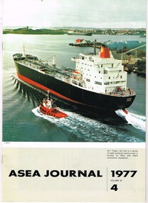
Magazine, ASEA Limited, "ASEA Journal 1977 - Vol. 50 - No. 4", Aug. 1977
Magazine - 24 pages - A4 full gloss paper - central stapled titled "ASEA Journal 1977 - Vol. 50 - No. 4", published by ASEA Pty Ltd. Has an article "New Trams for Melbourne" - written by Lars Friden, ASEA Transport division and Ross Coltman of ASEA Lilydale. Includes information on the tram itself, background, contractors, design, equipment, control equipment, internal and external photographs, under floor layout, bogies, electrical diagrams, panels, and layouts. See also Reg item 1603 for September 1976 issue about the 50th Z class delivery. 2nd copy added 10-1-2019trams, tramways, asea, sweden, mmtb, z class, electrical equipment, controllers -
 Kew Historical Society Inc
Plan, Melbourne & Metropolitan Board of Works : Borough of Kew : Detail Plan No.1576, 1904
The Melbourne and Metropolitan Board of Works (MMBW) plans were produced from the 1890s to the 1950s. They were crucial to the design and development of Melbourne's sewerage and drainage system. The plans, at a scale of 40 feet to 1 inch (1:480), provide a detailed historical record of Melbourne streetscapes and environmental features. Each plan covers one or two street blocks (roughly six streets), showing details of buildings, including garden layouts and ownership boundaries, and features such as laneways, drains, bridges, parks, municipal boundaries and other prominent landmarks as they existed at the time each plan was produced. (Source: State Library of Victoria)This plan forms part of a large group of MMBW plans and maps that was donated to the Society by the Mr Poulter, City Engineer of the City of Kew in 1989. Within this collection, thirty-five hand-coloured plans, backed with linen, are of statewide significance as they include annotations that provide details of construction materials used in buildings in the first decade of the 20th century as well as additional information about land ownership and usage. The copies in the Public Record Office Victoria and the State Library of Victoria are monochrome versions which do not denote building materials so that the maps in this collection are invaluable and unique tools for researchers and heritage consultants. A number of the plans are not held in the collection of the State Library of Victoria so they have the additional attribute of rarity.Original survey plan, issued by the MMBW to a contractor with responsibility for constructing sewers in the area identified on the plan within the Borough of Kew. The plan was at some stage hand-coloured, possibly by the contractor, but more likely by officers working in the Engineering Department of the Borough and later Town, then City of Kew. The hand-coloured sections of buildings on the plan were used to denote masonry or brick constructions (pink), weatherboard constructions (yellow), and public buildings (grey). Development in the 20th century has irreparably altered that part of Kew represented in this plan. In the block bounded by Cotham Road, Charles Street, Wellington Street and Gellibrand; just one house standing in 1903 remains. This block included two of the most historic houses in Kew: ‘Ordsall’ (later ‘Southesk’) and ‘Madford’ (previously ‘Elm Lodge’). Ordsall was the home of the second chairman of Kew, John Halfey. It contained some of the most significant interior murals in Kew, created for Halfey by artists working for Cullen & Co. It was demolished in 1960 to make way for the Kew Civic Centre. Elm Lodge had been built for William Siddeley in ca. 1864. Arthur Septimus King purchased it in 1874. The lower paddocks of Madford were sold in 1905 by his wife to the Borough of Kew and, after landscaping by George and Thomas Pockett, opened as the Alexandra Gardens in 1908. Elm Lodge/Madford was in 1922 to become St. Anthony’s Home for Little Children before its subsequent demolition in the 1980s.melbourne and metropolitan board of works, detail plans, maps - borough of kew, mmbw 1576, cartography -
 Kew Historical Society Inc
Plan, Melbourne & Metropolitan Board of Works : Borough of Kew : Detail Plan No.1297, 1904
The Melbourne and Metropolitan Board of Works (MMBW) plans were produced from the 1890s to the 1950s. They were crucial to the design and development of Melbourne's sewerage and drainage system. The plans, at a scale of 40 feet to 1 inch (1:480), provide a detailed historical record of Melbourne streetscapes and environmental features. Each plan covers one or two street blocks (roughly six streets), showing details of buildings, including garden layouts and ownership boundaries, and features such as laneways, drains, bridges, parks, municipal boundaries and other prominent landmarks as they existed at the time each plan was produced. (Source: State Library of Victoria)This plan forms part of a large group of MMBW plans and maps that was donated to the Society by the Mr Poulter, City Engineer of the City of Kew in 1989. Within this collection, thirty-five hand-coloured plans, backed with linen, are of statewide significance as they include annotations that provide details of construction materials used in buildings in the first decade of the 20th century as well as additional information about land ownership and usage. The copies in the Public Record Office Victoria and the State Library of Victoria are monochrome versions which do not denote building materials so that the maps in this collection are invaluable and unique tools for researchers and heritage consultants. A number of the plans are not held in the collection of the State Library of Victoria so they have the additional attribute of rarity.Original survey plan, issued by the MMBW to a sewage contractor with responsibility for constructing sewers in the area identified on the plan within the Borough of Kew. The plan was at some stage hand-coloured, possibly by the contractor, but more likely by officers working in the Engineering Department of the Borough and later Town, then City of Kew. The hand-coloured sections of buildings on the plan were used to denote masonry or brick constructions (pink), weatherboard constructions (yellow), and public buildings (grey). This plan of Kew encompasses the area bounded by Barkers Road, High Street and Stevenson Street. Because of the angle created by High Street, a number of houses on the northern side of High Street are shown. The area is dominated by one of the great original landholdings in Kew, described here as the ‘Findon Paddock’. ‘Findon’, the house from which the name of the paddock was taken fronts Stevenson Street and was clearly a rambling structure. The best-known occupant of Findon was Henry ‘Money Miller’ who bought the house in 1871. Miller was a member of Victoria’s first parliament and assisted in the framing of its constitution. Findon was to be subdivided as early as 1912, when the Findon Subdivision was advertised to be sold by auction. In the plan of the subdivision, the original house is not shown, so, presumably it had previously been demolished. Fincham & Son moved the organ, built by Henry Willis, which was installed in the house, first to ‘Whernside’ in Toorak, and later to the Box Hill Methodist Church.melbourne and metropolitan board of works, detail plans, mmbw 1297, cartography, kew (vic.) — municipal collection -
 Kew Historical Society Inc
Plan, Melbourne & Metropolitan Board of Works : Borough of Kew : Detail Plan No.1568, 1905
The Melbourne and Metropolitan Board of Works (MMBW) plans were produced from the 1890s to the 1950s. They were crucial to the design and development of Melbourne's sewerage and drainage system. The plans, at a scale of 40 feet to 1 inch (1:480), provide a detailed historical record of Melbourne streetscapes and environmental features. Each plan covers one or two street blocks (roughly six streets), showing details of buildings, including garden layouts and ownership boundaries, and features such as laneways, drains, bridges, parks, municipal boundaries and other prominent landmarks as they existed at the time each plan was produced. (Source: State Library of Victoria)This plan forms part of a large group of MMBW plans and maps that was donated to the Society by the Mr Poulter, City Engineer of the City of Kew in 1989. Within this collection, thirty-five hand-coloured plans, backed with linen, are of statewide significance as they include annotations that provide details of construction materials used in buildings in the first decade of the 20th century as well as additional information about land ownership and usage. The copies in the Public Record Office Victoria and the State Library of Victoria are monochrome versions which do not denote building materials so that the maps in this collection are invaluable and unique tools for researchers and heritage consultants. A number of the plans are not held in the collection of the State Library of Victoria so they have the additional attribute of rarity.Original survey plan, issued by the MMBW to a contractor with responsibility for constructing sewers in the area identified on the plan within the Borough of Kew. The plan was at some stage hand-coloured, possibly by the contractor, but more likely by officers working in the Engineering Department of the Borough and later Town, then City of Kew. The hand-coloured sections of buildings on the plan were used to denote masonry or brick constructions (pink), weatherboard constructions (yellow), and public buildings (grey). Plan No.1568 covers the area bounded by Cotham Road, John Street, Sackville Street, and Edward Street. Alfred Street and Rowland Street are in shown in the middle of the plan. The two most notable buildings shown are ‘St Helliers’, the home of the Dumaresq family, and St Hilary’s Church and school. While the colours used to indicate St Hilary’s are grey as in other civic/public buildings, the first St Hilary’s Anglican Church was at this stage constructed in weatherboard. At the left of the plan, facing Sackville Street is a house named ‘Glencara’. The 1988 ‘Kew Conservation Study’ recorded that “The first documentary evidence of this house comes from Rate Books which record that in 1893 a Mrs Treadway was the owner of this building with an N.A.V. of £81? At that date the occupier of the house was Charles B. Kelly, a clerk, while by 1910 Kelly had become the owner of the property described in that year ‘as a six-roomed stone, brick and wood house with stables and outbuildings’”. Contrary to this description, the 1905 plan indicates that the house was entirely constructed of masonry.melbourne and metropolitan board of works, detail plans, mmbw 1568 -
 Kew Historical Society Inc
Plan, Melbourne & Metropolitan Board of Works : Borough of Kew : Detail Plan No.1571, 1904
The Melbourne and Metropolitan Board of Works (MMBW) plans were produced from the 1890s to the 1950s. They were crucial to the design and development of Melbourne's sewerage and drainage system. The plans, at a scale of 40 feet to 1 inch (1:480), provide a detailed historical record of Melbourne streetscapes and environmental features. Each plan covers one or two street blocks (roughly six streets), showing details of buildings, including garden layouts and ownership boundaries, and features such as laneways, drains, bridges, parks, municipal boundaries and other prominent landmarks as they existed at the time each plan was produced. (Source: State Library of Victoria)This plan forms part of a large group of MMBW plans and maps that was donated to the Society by the Mr Poulter, City Engineer of the City of Kew in 1989. Within this collection, thirty-five hand-coloured plans, backed with linen, are of statewide significance as they include annotations that provide details of construction materials used in buildings in the first decade of the 20th century as well as additional information about land ownership and usage. The copies in the Public Record Office Victoria and the State Library of Victoria are monochrome versions which do not denote building materials so that the maps in this collection are invaluable and unique tools for researchers and heritage consultants. A number of the plans are not held in the collection of the State Library of Victoria so they have the additional attribute of rarity.Digital copy of the original survey plan, issued by the MMBW to a contractor with responsibility for constructing sewers in the area identified on the plan within the Borough of Kew. The plan was at some stage hand-coloured, possibly by the contractor, but more likely by officers working in the Engineering Department of the Borough and later Town, then City of Kew. The hand-coloured sections of buildings on the plan were used to denote masonry or brick constructions (pink), weatherboard constructions (yellow), and public buildings (grey). This plan is part of a large and historically significant group of MMBW plans and maps that was donated to the Society by the Mr Poulter, City Engineer of the City of Kew in 1989. When the contracts were let for surveyors to identify and record the extant houses and landscapes within an area for the Board of Works, the contracts were let at separate times, hence the anomaly where two copies of Plan No.1571 exist in our collection. The first of these plans identifies the building materials used in houses bordering Fitzwilliam Street, Edgevale Road, May Street, Malin Street, Davis Street and Wellington Street. The cut off point for the survey was the south side of Wellington Street. By 1903 when the survey was undertaken many of the sites were already built on, particularly those facing Edgevale Road. The plan identifies the preponderance of weatherboard houses in the area. The other version of the plan identifies the buildings between Wellington Street and Cotham Road.melbourne and metropolitan board of works, detail plans, mmbw 1571, cartography -
 Warrnambool and District Historical Society Inc.
Book, John Ross notebook, 1890s
This small note book belonged to John Ross, the Warrnambool Town Surveyor and Engineer (1889-1906 & 1913-1914). The book lists the levels taken for the benefit of contractors undertaking jobs for the Warrnambool Council from 1898 to 1902. The jobs include ‘Russells Creek from the Merri River upwards’, ‘Outlet at the Flume’, ‘Guns at the Battery’ and Drainage from the Terminus Hotel to the end of the Japan Street Tunnel’. John Ross was also in private practice with the architectural firm of Ross and Jackman. This notebook is of considerable interest because it is an original note book that belonged to John Ross, the Warrnambool Town Surveyor and Engineer in the late 19h century and early 20th century. The note book contains important information on the engineering projects in Warrnambool and district from 1898 to 1902. This note book has a red leather cover. The cover is a little creased. The inside pages have ruled red lines and printed headings regarding the levels taken of a site and the location of the site (1898 to 1902). The engineer’s entries in the printed columns are handwritten , mostly in pencil. The inscription on the first page is handwritten in black ink. ‘Jno C Ross, Town Surveyor Wbool 19/5/98’ john ross, warrnambool town council, history of warrnambool -
 Warrnambool and District Historical Society Inc.
Administrative record - Haberfield ledgers, early 20th century
These two ledgers, used between 1913 and 1926, come from the Haberfield family. James Haberfield came to the Warrnambool area from England in the mid 19th century and with his wife established a property, 'The Briars' at Dennington, near Warrnambool. Two sons, James Bertram and William, were cartage contractors and cash produce buyers in the first half of the 20th century with the business based in Fairy Street and Farnham ('The Briars'). These two ledgers contain the business dealings of the Haberfield Bros. business in the 1910s and 1920s. These ledgers are of considerable interest as they record the business details of an important early cartage and produce business in Warrnambool. Also the Haberfield family was a prominent one in Warrnambool in the 20th century. The building that contained the produce store run by William Haberfield at the corner of Fairy and Lava Streets still survives..1 This is a ledger with a black cover with a beige leather spine and edges and a red and gold label. The pages are ruled with red and blue lines and contain handwriting in black ink. The spine is a little scuffed. .2 as above but with an alphabetical listing at the front section and with no scuffingCash Book Ledger Haberfield, J.B. Ledger From Folio 270warrnambool produce stores -
Eltham District Historical Society Inc
Document - Folder, Patching, Ian
Ian Patching lived in Wattle Glen. He worked in youth services, later Youth Services Co-ordinator and he worked at Edendale Community Farm in a community development role, As a contractor he worked at Montmorency Secondary College, Whittlesea Secondary College and Diamond Valley College (the later also with Peter Sartori aka Ticarno Sartori), He volunteered with Hurstbridge Youth Activity Centre with Jack Lawson and Martin Drews. Contents Email exchange 2014: Enquiry and research.Newspaper clippings, A4 photocopies, etcian patching, youth services in eltham, edendale community farm, hurstbridge youth activity centre', wattle glen, jack lawson, martin drews, montmorency secondary college, whittlesea secondary college, diamond valley college, peter sartori, ticarno sartori -
 Eltham District Historical Society Inc
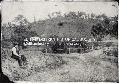
Negative - Photograph, Mr Belot smokes his pipe whilst resting at Cottle's Bridge, c.1990 (c.1890)
Copy of original photograph. The area, previously known as Back Creek, was named after Thomas Cottle, who settled in the district in the 1870s, and the original bridge over the Diamond Creek on the road to Strathewen. The original bridge (seen in the photo) was replaced with a new timber bridge at a cost of £1,500, the tender being awarded to a contractor named Birch who commenced work in June 1927. The gentleman in the photo who is resting whilst having a smoke of his pipe is a member of the Belot family.Roll of 35mm Black and White negative film, 3 strips, (1 of 14 frames)Film - Agfa Ortho 25belot, bridge, cottles bridge, cottles bridge-strathewan road, diamond creek (creek), heidelberg-kinglake road -
 Puffing Billy Railway
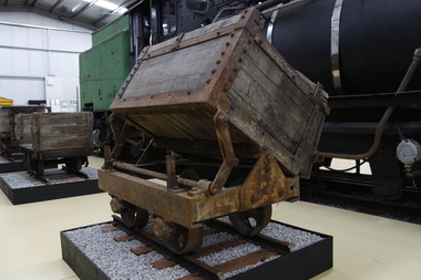
Side Tipping Timber Skip, circa 1900?
Side Tipping Timber Skip Wooden Contractors Wagon. Gauge 17 inch (430mm) Typical of the many side tipping wagons used for soil and rock disposal in construction work and mining throughout Australia and the world. The wagon would be loaded with soil and pushed along a short line to the end of track where the load would be emptied out to either side. By using a central pivot the wagon’s body can be tipped either side to allow the contents to be easily removed ready for the next load.Historic - Industrial Narrow Gauge RailwayWooden bodied, steel framed side tipping skip.puffing billy, side tipping skip, industrial narrow gauge railway -
 Lakes Entrance Historical Society
Photograph - Old Church House, Tambo Upper, Anne Macarthur, 9/10/2010 12:00:00 AM
The old Church House served the Bruthen community in 1880s when no longer required it was barged to the New Works area where it became Church and meeting hall. By the time the Entrance work was completed the contractor J R Coate had the building moved to Church Street Lakes Entrance. It was a home for various local families until abandoned then acquired by Val Northrope. After renovation by Val in Lakes Entrance it was moved again to a site beside the Northropes new home at Tambo UpperColour photograph of timber cottage surrounded by picket fence four women at gateway. Cottage situated near Bruthen Victoria. Also eight more colour photographs taken of same house showing various aspects of building. houses, land settlement, churches -
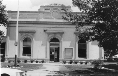
 Stawell Historical Society Inc
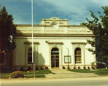
Photograph, Stawell Shire Hall 1866 c1980s -- Coloured
Colour Photo Stawell Shire Hall built 1866, c1980. The Shire Hall is in Longfield Street Stawell and has had many changes since 1866. Ronald Campbell, the Shire's second president laid the foundation of the hall on 28th April 1866. The contractors were Hutchings and Delbridge. The first Hall and office were the front part of the existing building. These rooms consisted of two 18 ft square rooms with an entrance hall separating them. The facade was almost the same as it is today. The building cost 502 pounds.Colour photograph of Stawell Shire Hall 1866. Very similar view to 0084 the photo clearly showing the two windows and arched entrance door. Landscaping outside the building is exactly the same as in 0084. stawell -
 Stawell Historical Society Inc
Photograph, Stawell Shire Hall Built in 1866
Stawell Shire Hall built 1866. These photographs of the Shire Hall, Longfield Street Stawell. This building has had many changes since 1866. Ronald Campbell, the Shire's second president laid the foundation of the hall on 28th April 1866. The contractors were Hutchings and Delbridge. The first Hall and office were the front part of the existing building. These rooms consisted of two 18 ft square rooms with an entrance hall separating them. The facade was almost the same as it is today. The building cost 502 pounds. Black and white photograph of a brick building which has been cement rendered with a parapet on top. The front of the building has 2 arched windows and arched entrance door. A glass notice board to the right of the door. Shire Hall 1866 is written on the top front of the building. Many small flower pots line either side of the front entrance with a flag post in the lawn on the left. stawell -
 Bendigo Historical Society Inc.
Document - FOR HISTORICAL SOCIETY BENDIGO BRANCH NEWSLETTER
Handwritten copy of items for the Newsletter. Included is Machinery Contractor Called to Task. He took a lot longer to do the work than he should have. Boys Will Be Boys tells of a boy who was supposed to driving the whim horse, but in the absence of the braceman, he amused himself by taking a truck out of the cage and putting it back again. Then he started stepping backwards and forwards by holding onto a rope across the shaft, then fell down the shaft. He got a severe shaking. Cheers and Groans are about the long hours the miners worked and the introduction of the 8 hour day. Primitive Shafts is about the Victoria Reef Shafts. It tells of the underground working and raising the ore, crushing and yield.document, for historical society bendigo branch newsletter, federal australian, st mungo crushing battery, a richardson, royal hotel, bendigo advertiser, angus mackay, regulation of mines 1874, victoria reef quartz co, victoria quartz, grant and co, dicker's mining record 23/11/1861 pages 9 and 10 -
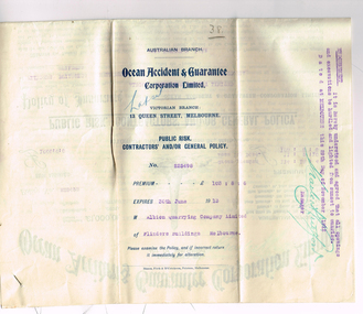 Melbourne Tram Museum
Legal record - Insurance Policy, The Ocean Accident and Guarantee Corporation Limited of London - Victorian Branch, "Public Risk Contractors and/or General Policy", 26/11/1912 12:00:00 AM
.1 - Insurance Policy - six fold - titled "Public Risk Contractors and/or General Policy" from "The Ocean Accident and Guarantee Corporation Limited of London - Victorian Branch" to the Albion Quarrying Company Limited, dated 1/12/1912, expiring 30/6/1913. Gives details of the policy, who was covered, amount, premium and conditions. Endorsed by the Insurers Manager as to the requirement that all openings and excavations be lit at night. Possibly for the Construction of the Malvern Tramway but not detailed as such. .2 - handwritten receipt on preprinted sheet No. 15101, receiving the premium for the above policy, dated 26/11/1912. Gives details of the sum assured, signatures and has a State of Victoria stamp duty stamp on the left hand side."38" in ink in top right hand corner.trams, tramways, construction, pmtt, insurance, contracts, employees, receipts -
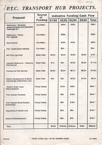 Melbourne Tram Museum
Document - Report, Public Transport Corporation (PTC), "PTC Transport Hub Projects", 1992
Reports and associated documents for the PTC Transport Hub Projects - Better Cities Funding - Commonwealth and State Government projects - 1991 through to 1995. .1 - list of projects, timing, source of funding, project description and timing - about 25 sheets. .2 - four sheets stapled - providing a timeline for the Mill Park Light Rail project and tram system overhead renewal projects. .3 - six sheets - listing the tram projects - overhead, automatic points, track renewal and giving time lines in a Gantt chart. .4 - Newspaper cutting advertising for the pre-qualification of contractors for PTC electric traction - rail and tram as part for the Transport Hub project; - The Age 20/5/1992trams, tramways, ptc, funding, mill park, overhead, trackwork -
 Warrnambool and District Historical Society Inc.
Document, Gauley contracts .1 & .2, C 1878
In 1858 a tramway was constructed to move goods between Warrnambool township and jetty on Lady Bay which was over a mile away The terminus was established on the southern side of Merri Street. and the track went around the edge of Lake Pertobe reserve. Large stores were also built near where the present railway station is situated to hold produce and carriages. These documents relate to contracts between Marion Gauley ,contractor of Warrnambool and the borough of Warrnambool for the operation of horse work with the tramway. John McDermid sadler,and William Stevens farmer of Russell's Creek are acting as surety for the contract.The tramway was an important part of Warrnambool's infrastructure and history and the documents also include names of local people. Of particular interest is the fact that the contract in this case was given to a woman which would have been a little uncommon at that time.001259.1 Pale blue lined paper with red lined outline.Hand written in black pen with names and some other words underlined in red. Two signatures on bottom right with red seal beside each. Witness signature below on left hand side. One page only 001259.2 Pale blue lined paper with red lined outline.Hand written in black pen with names and some other words underlined in red. Two signatures on bottom right with red seal beside each. Witness signature below on left hand side. Of the four pages of the document , only the first page is used. 001259.1 Signed Roady Carew and Moses Daly. Richard Daly is crossed out in the document and Marion Gauley is inserted in greylead. September 1878 001259.2 John McDermid saddler William Stevens, Marion Gauley. Ninth of December 1878. warrnambool, warrnambool tramway, marion gauley, john mcdermid, william stevens -
 Bendigo Historical Society Inc.
Document - Graylings 90 Moore Street, Bendigo, 1988
The house was designed in 1924 by Harold Desbrowe Anneal and described as ahead of its time. Born in Happy Valley, Bendigo, Victoria in 1865, Desbrowe Annear was the elder son of James Annear, mining contractor, and Eliza Ann (née Hawkins). In 1883, Desbrowe-Annear was articled to Melbourne architect William Salway and during this time his interest and knowledge of architecture grew extensively. In 1889 he chose to pursue a practice of his own having already received recognition for his architectural sketches and papers delivered to the Victorian Institute of Architects. Source Wikipedia.Letter from National Trust to new owner re the Design of the House and its importance.history, national trust bendigo collection, bendigo, harold desbrowe anneal -
 Bendigo Historical Society Inc.
Document - Bendigo Home and Hospital for the Aged, 1860-1970s
The inaugruration of the newly erected Benevolant Asylum took place on 15th March 1860. The asylum is situated on the west side of Commissioner's Gully, Barnard Street, Bendigo. The building itself is the design of Mr Robert A. Love, Architect, the Contractor is Mr Crawford and the Clerk of Works, Mr Wrigley. - from the Bendigo Advertiser 16th March 1860. In the Advertiser Dec 20 1872: the Memorial Stone was added and the design for the front elecvation was carried out as origionally planned with 12 columns of brick and cement each 36 feet high, the bases of which are granite. Typed History of the hospital, and letters regarding classification status and two A4 sized photos of the front of the building.history, national trust bendigo collection, bendigo, benevolant home bendigo, benevolant asylum bendigo, home and hospital for the aged bendigo, ann caudle centre bendigo -
 Kew Historical Society Inc
Photograph - 'Berrington', 29 Sackville Street, Kew, 1988
'Berrington' in Sackville Street was built in 1888 for Job Smith, builder, who was the first owner of this substantial two-storey house. The property was given an initial N.A. V. of £125 3 and it is possible that Smith was the contractor for his house.By the turn of the century 'Berrington' was identified as having thirteen rooms and an N.A.V. of £13 while the house remained in the hands of the Smith family until the late 1930s. The new owner at that stage was a Mrs Pederson who convened the house into three flats 6 while in 1951 it was further subdivided to become seven units. (Kew Conservation Study, 1988)Colour photographic positive of one of 'Berrington'. The building is a large two storeyed house typical of the late Victorian period. It remains substantially intact with a cast iron verandah dominating the front and side facades, that has the added distinction of a fine cast iron frieze that at ground floor level has two tiers. Behind the verandah, the facade is asymmetrical. There is a central six panelled door with a fine semicircular fanlight, and segmentally arched windows to the ground floor and on one side of the door there is a polygonal bay window that extends up the two floors. The eaves and chimneys are decorated with Italianate brackets. (Kew Conservation Study, 1988)berrington -- sackville street -- kew (vic.), job smith -
 Melton City Libraries
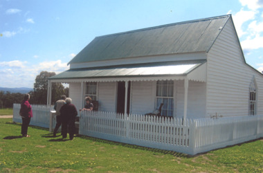
Photograph, Ned Toohey's house, McKenzie Street, 1970
Cottage of Edward Toohey (died 1898) a Shire contractor and road maker. Ned, his son worked with Frederick Myers building many of the bluestone roads in the Shire of Melton. In the background is the brick house built for Martha Myers in 1967. Martha and husband Frederick (born 1877 in Melton) resided in the Myers (Miers) house on Western Highway beside the gully near Reserve road. Frederick lived there for 86 years. The house was built in 1867 by Henri and Ann nee Dowling Myers. Demolished 1968. Martha Myers house was demolished in 2011 to become a car park. Mary and Jack Tolhurst removing roof of Ned Tooheys house (site of Senior Citizens ).local identities, misc. -
 Linton and District Historical Society Inc
Photograph, Louisa Caroline Grigg
Born at Spring Hill in 1866, Louisa Spencer married William Michael Grigg, a carrier/haulage contractor, in 1891. They lived in Ballarat where their first two children were born, then moved to Linton in about 1895. For a short period after this the family went to Western Australia, before returning to Linton in about 1900. Louisa and William Michael Grigg had five children - Georgina Myra (called Ena), Lilian Violet (called Cis), William Spencer (eventually known as "Bill Grigg Snr"), Nellie, and Spencer Lancelot. Louisa Grigg died in 1952.Black and white copy of original photograph of an older lady wearing glasses and a black hat with a feather on the left. She is wearing a light coloured outfit with a white collar and lots of buttons down the front. Louisa Caroline Grigg (Mrs. W. M. Grigg)"Mrs W Grigg, mother of Mr Billy Grigg."louisa caroline grigg (née louisa caroline spencer) -
 Whitehorse Historical Society Inc.
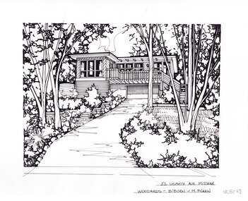
Artwork, other - Ink Line Drawing, Margaret Picken, 52 Lisbeth Ave., Mitcham, circa 1990's-2000's
A property illustration by Margaret Picken Commissioned by a real estate agency for the purpose of advertising 52 Lisbeth Ave., Mitcham Made by using Rotring ‘Rapidigraph’ drafting pens with Rotring ink on Rapidigraph polyester drafting film, double matte. Trained as a cartographic draftsman within the mining industry, Margaret Picken is an artist who worked producing property illustrations for real estate agencies in eastern suburbs of Victoria from 1983-2005. Retiring from the industry as technological changes favored coloured photography over illustrations, and commissioning companies over sole contractors.This artwork is of Historical Significance as a record of local domestic architecture.A black ink line drawing on drafters film by Margaret Picken, of 52 Lisbeth Ave., Mitcham depicting a black and white line drawing of a two story house with built in garage perched at the top of a steep driveway winding up from the centre foreground. There is garden either side, with gumtrees and shrubs. There are two holepunch holes centered just under the upper edge52 Lisbeth Ave., Mitcham Woodards - b/burn - M.Pickenwhitehorse historical society, schwerkolt cottage, housing, architecture, margaret picken, house, garden, real estate, mitcham