Showing 15695 items
matching docuents-maps-france
-
 Clunes Museum
Card
CHRISTMAS CARD SENT TO HANNAH IN 1914 FROM NORMAN THOMAS IN FRANCE W.W.1local history, docoment, christmas card, w.w.1 memorabilia -
 Dandenong/Cranbourne RSL Sub Branch
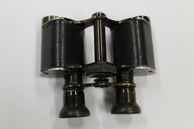
Binoculars, ETABL TS 'AFSA'
WW1 historical significanceWWI French Military Binoculars, ETABL AFSA Paris Series 6 with leather case.ETABL TS 'AFSA' Paris. Series 6 MG S2 157.51 -
Beechworth Honey Archive
Map- Everton
Map compiled from 1975 aerial photography. Printed in 1979.Map shows Everton, Ovens River, Beechworth- Wangaratta Rd, former Wangaratta- Bright railway. Scale 1:25,000. Printed colour on paper.Map labelled Everton. No. 8225-3-3.map, everton, ovens river, bright, railway, aerial, photography, paper, beechworth honey -
 Orbost & District Historical Society
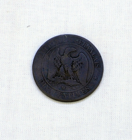
coin, 1855
Eagles on coins do not necessarily indicate that they are American eagles or coins from the United States but they are symbols of strength or power. The 10 Centimes was made at various mints and the mint mark appears as a single or double letter below the eagle.This pattern with Napoleon appears on bronze French coins from 1852 to 1865. This coin reflects the late 19th century history of France.A bronze 1855 French 10 Centimes. The denomination is on the reverse: " DIX CENTIMES" around an eagle with open wings. Above that is: "EMPIRE FRANCAIS" or French Empire. On the obverse is: "NAPOLEON III EMPEREUR BARRE 1855" around the head of man facing left.coin french-ten-centime napoleon -
Coal Creek Community Park & Museum
Pearl buttons
Rectangular piece of light green cardboard. 24 buttons attached by cotton.Extra superfine thistle brand. Made in France. -
Coal Creek Community Park & Museum
Pearl buttons
24 pearl buttons attached by cotton to light green rectangular shaped cardboard. Extra Superfine. Thistle Brand. Made in France. -
Coal Creek Community Park & Museum
Pearl buttons
24 pearl buttons attached by cotton to light green rectangular shaped cardboard. Extra Superfine. Thistle Brand. Made in France. -
Coal Creek Community Park & Museum
Pearl buttons
24 pearl buttons attached by cotton to light green rectangular shaped cardboard. Extra Superfine. Thistle Brand. Made in France. -
 Whitehorse Historical Society Inc.
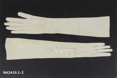
Clothing - Gloves
Long pale grey gloves with three buttons at wrist.Jays Washable Suede Made in France by Fownescostume accessories, glove accessories -
 Federation University Historical Collection
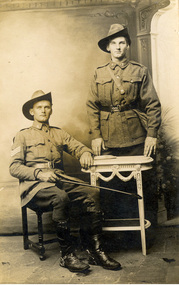
Postcard - photographic, Sergeant French and Driver French, c1916
Image of the French brothers posing from a photograph while dressed in the AIF uniform during World War One.Verso in pencil: "On the left is Sergeant French and on the right is Driver Frenchchatham family archive, chatham, holmes, world war, world war 1, world war i, world war one, france. french -
 Bendigo Military Museum
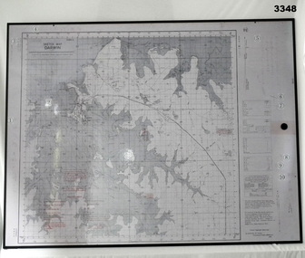
Map - MAP, MOUNTED, WW2, Possible pre WW2
This sketch map is a copy of the original found in Tokyo after the 1939 - 1945 War. Note that Japanese writing that has been added.Copy of Sketch Map of Darwin prepared by Australian Section Imperial General Staff. Mounted on board backing with laminated surface added, black border around edge, hanging strap on back. A detailed map of Darwin area giving convergence & time correction figures for artillery purposes.Top left words: “Sketch Map Darwin”map, darwin -
 Kew Historical Society Inc
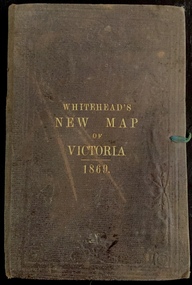
Map, Whitehead's Map of Victoria, With Alphabetical Key, 1869, 1869
When E. Whitehead's New Map of Victoria was released in 1869, an advertisement in the Bendigo Advertiser (16 July 1869) noted that: "This beautifully engraved Map has been revised and brought down to the present time; and, with the Alphabetical Key, is the most complete and the cheapest Map ever published; Price, 6d plain; 1s colored; 2s 6d in case; on linen, post free, 2d extra. E.. WHITEHEAD and CO, Publishers, 67 Collins-street east." The following year, 1870, Whitehead's promoted the edition in the Portland Guardian and Normanby General Advertiser (3 January 1870), advising that: "WHITEHEAD'S NEW MAP OF VICTORIA, 1869 ... is corrected to the latest date, and around is arranged an Alphabetical Key, with Post Towns and Money Order Olffices marked. The Map being divided into squares and numbered, by reference to the Key any place can be found immediately. Price Is beautifully colored, or mounted on linen in case, 2s 6d. Post free, 2d extra, in Victoria. B. Whitehead and C0., Puolishers, 67 Collins-street East, Melbourne". In the same edition of the Portland Advertiser, they also promoted their business generally, saying: "E WHITEHEAD and Co., Stationers, Engravers, Lithographers, 67 Collins street East, execute every description of Lithographic PRINTING, BILL-HEADS. NOTE Headings. Business Dies Engraved and Embossed on Envelopes &c. ARMS, MONOGRAMS, AND CRESTS Engraved and Embossed in Colour, superior to any other house in the Colony. Specimens, post free, 2d. Lithographers, &c, to H.R.H. the Duke of Edinburgh, and Die-inkers and Embossers to His Excellency Sir J. H. T. Manners-Sutton, K C.B. Orders executed for the Trade". Whitehead’s New Map of Victoria 1869 is is an important record of region created towards the end of the Victorian Gold Rush (1851-1869). In addition to its historical significance, this is a rare map, of which the only known copies in Australian public collections are those held at the National Library of Australia, the State Library of Victoria, State Library of New South Wales and the University of Queensland Library.Map of Victoria with gold mining areas, notes on topography, transport routes. Relief shown by hachures. List of towns with distance from Melbourne in map margin. [Melbourne] : Printed & Published by ... E Whitehead & Co ... 67 Collins Street East, 1869 1 map : col., mounted on linen ; 38.4 x 55.4 cm, folded to 18 x 12 cm.Cover "WHITEHEAD'S NEW MAP OF VICTORIA 1869"maps - victoria - 1860s, e whitehead's new map of victoria 1869, whitehead's map of victoria with alphabetical key 1869, cartography, gold rush -
 Bendigo Military Museum
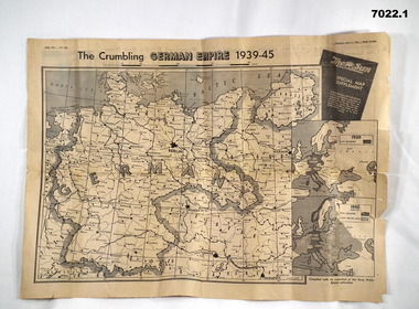
Newspaper - NEWSPAPER EXTRACTS
... Maps ...The various map extract showed the position of the German Control of Europe at the point of time in 1944 and April 1945 near the end. Was for general issue at a time when Allied Forces were on top moving towards German lines.Yellow faded paper, black writing and b & W photos. 1. Four page extract from Newspaper "The Sun" with centre pages having a detailed map of the European Theatre of War dated 11 April 1945. front and Back pages covering normal news items. 2. Four page extract from "The Sun" newspaper giving a phasing of German control of Europe over period of War and a detailed map of position as at 5th August 1944. Final page lists key dates in the history of the War.1. Map headed "The Crumbling German Empire 1939-45". 2. Maps headed "The War Map".ww2, europe, maps, newspapers -
 Federation University Historical Collection
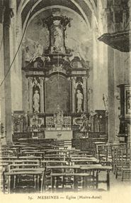
Postcard - Black and White, Messines Maitre Autel (altar), c1917
WW1 Australian soldier Holmes Famiiy memento.Black and white postcard sowing the interior of a church at Messines, France. A large altar dominated the image. chatham-holmes family collection, messines, church, altar, postcard -
 Vision Australia
Photograph - Image, Using a 3D map of Sydney
... Maps ...A blind man feels model buildings on a relief map of the Sydney CBD whilst two others look on. B/W photograph of blind man using relief mapLearning layout of City of Sydney by raised map Orientation - historical RBS XIroyal blind society of nsw, maps -
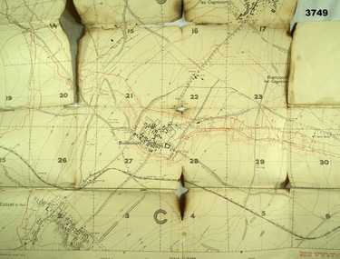 Bendigo Military Museum
Map - TRENCH MAP WW1, 1917
Areas covered on this map are, “Bullecourt, Reincourt, Hendecourt”. Item relates to William Alexander No 502 AIF. Refer Cat No 3746.3 for his service details.Trench map, France, scale 1:10,000, German trenches in red, trenches corrected to 6.4.1917, Edition 2.map, france, trench -
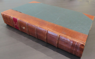 Federation University Historical Collection
Book, Denis Diderot et al, Recueil de planches sur les sciences, les arts libereaux, et les arts mechaniques avec leur explication, 1868, 1768
This book was discovered beneath the floor of a former Ballarat School of Mines office during renovations in 1970. It appears to have been placed there in safe storage, then forgotten for decades. Both State Library of Victoria and Monash University have a full run of all 10 volumes of Recueil de planches sur les sciences, les arts libereaux, et les arts mechaniques avec leur explication. This copy is the sixth volume, and contains 294 pages. School of Mines stamps are dated 1870. Etchings by Benard Fecit and Louis-Jacques Goussier (1722-99). Goussier was a French illustrator and encyclopedist.Large hard covered book of 294 beautifully printed plates on handmade paper. Each plate has descriptions written in French. Along with animals and natural history the images also include mining, metallurgy and mineralogy. Rebound in 1987 with green cloth and leather spine and corners. Gold lettering on the spine. Ballarat School of Mines stamp on the back of each image, dated 1870.printed plates, animals, natural history, metallurgy, mineralogy, mining, minerology, etching, 1768, french, science, briasson, david, le breton, sixth volume -
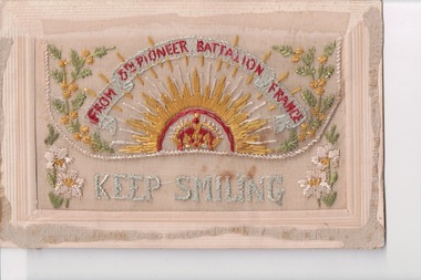 Wangaratta RSL Sub Branch
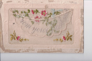
Postcard - Embroidered Postcard, c. 1917
Postcard from WWI soldier William West (1268) of the 29 Infantry Battalion, 5th Pioneers Battalion while posted in France to his family at home.Embroidered silk postcards were first made in 1900 for the Paris Exposition. The popularity of silk postcards peaked during the First World War 1914 - 1918.They were mostly embroidered by French women in their homes and then sent to the factories for cutting and mounting on cards. Many of the cards were illustrated with patriotic symbols, flags, slogans, or sentimental texts. During the First World War, many Allied officers and soldiers based in France sent silk embroidered postcards to their loved ones back homeWhite rectangular postcard with embroidered yellow rising sun, crown, banner and foliate decoration. Handwritten message on backFront: "FROM 5TH PIONEER BATTALION FRANCE" "KEEP SMILING" (embroidered) Back: "To Enid best love from Dad xxxxxx / France June 28/6/1917" "My Dear Mary / just a pc to let you know I'm still well and hope you are all the same I have not seen Joe yet is is still warm over here yet we have been out shooting to day I feel tired. I wish it was all over I full up of it. I seen Dexter the other night he is looking well on it ?? I'm beginning to think it is never going to end well this all at present love Will love from your loving husband xxx / xxxx " wwi, postcard, embroidered postcard, carte postale -
 Whitehorse Historical Society Inc.
Map - Civic Map, Subdivision of Village of Springfield, 1861
Map of the subdivision of the Springfield Estate, Nunawading, 1861. The Springfield Estate was located in the Northwest corner of Whitehorse Road and Springvale Road.Map of the subdivision of the Springfield Estate, Nunawading, 1861. Springfield Estate was located in the Northwest corner of Whitehorse Road and Springvale Road.non-fictionMap of the subdivision of the Springfield Estate, Nunawading, 1861. The Springfield Estate was located in the Northwest corner of Whitehorse Road and Springvale Road.springfield estate, whitehorse road nunawading, springvale road nunawading -
 Wangaratta RSL Sub Branch
Postcard - Embroidered Postcard, c. 1917
Postcard from WWI soldier William West (1268) of the 29 Infantry Battalion, 5th Pioneers Battalion while posted in France was sent to his wife at home, 1917.Embroidered silk postcards were first made in 1900 for the Paris Exposition. The popularity of silk postcards peaked during the First World War 1914 - 1918.They were mostly embroidered by French women in their homes and then sent to the factories for cutting and mounting on cards. Many of the cards were illustrated with patriotic symbols, flags, slogans, or sentimental texts. During the First World War, many Allied officers and soldiers based in France sent silk embroidered postcards to their loved ones back homeWhite rectangular postcard with embroidered pink flower and green foliate decoration on front. Handwritten message on the back.Front: "From your husband" (embroidered) Back: "Write soon / Best Love / to West / do not forget to / send that / France / Jan 23/1/1917 / My Dear Alice / Just a P.C. to let you know I'm still well and hope you are all the same Best love / to all from Will xxxxxxxxxxxxx"wwi, postcard, embroidered postcard, paris depose, fabrication francaise -
 Coal Creek Community Park & Museum
Razor Box
Rectangular plain black container in two parts holding a razor. Razor with metal blade that folds into black plastic handle.Marked on blade: LE GRELOT THIERS - FRANCE #2' -
 Ballan Shire Historical Society
Map - Map. Ballark, Department of Lands and Survey, Ballark. County of Grant, 31/08/1915
A map of the Ballark area within the County of Grant showing roads, waterways, property boundaries and property owners in 1915.Significant to people researching land usage and ownership. Also those researching families in the area at that time.A map of Ballark in the County of Grant. Black printing on buff coloured paper. Extra notations by hand and various coloured highlighting of certain features. Details roads, rivers, property boundaries and names of property owners and districts. The map is easily readable although there is some physical damage to the borders and some sellotape residue. Shows a scale in Chains and the number L.6030Various numbers and directional arrows added to map.bungal, borhoneyghurk, bungeeltap, ballark, beremboke, moreep, meredith, morrisons, moorarbool river -
 Greensborough Historical Society
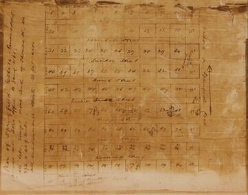
Folder, Hume Street Improvement Committee, 1958_
The Hume Street Improvement Committee was one of several 'progress associations' in the Greensborough area at the time the area was being urbanised. A typed page explains the concerns of residents when the street was being paved. Includes photographs and maps of area.These documents are concerned with the urbanisation of Greensborough in the mid 20th century while residents tried to maintain the rural feel of the area.Foolscap manilla folder containing various lists, maps and photographs.On cover "Hume Street Improvement Committee/ spare circulars/maps"greensborough, road making, brian roberts, hume street improvement committee, briar hill -
 Bendigo Military Museum
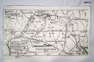
Map - MAPS FRANCE WW1, All 1918
... maps ...(.2) Areas on map relate to : The Hindenburg line on the left, from the top, Bony to Bellicourt to Bellenglise, Estrees to Brancourt. (.3) The River Somme runs through from top corner left bottom corner right. Main areas are Belloy, Picquigny, Bertangles, Montieres. The map finishes just short of “Amiens” Items in the collection relating to F.A.W Hutson No 3539 AIF. refer Cat No 922 for his service history.(.1) Map on paper showing the “Battle of August 1918”, Map C, The Advance to “Lions & Proyart”. (.2) Trench map, gauze lined, sheet 62B N.W, trenches corrected to 8.2.1918, German trenches in blue, scale 1:20,000, France. (.3) Ordnance survey map, May 1918, France, Edition 1, sheet 62 E N.E, scale 1:20,000, a canal and river runs through the centre(.2) On rear hand written “62 B N.W” (.3) On rear hand written “D.M.F 62 E N.E”august 1918, maps, somme -
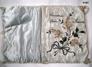
 Bendigo Military Museum
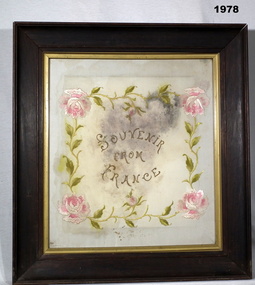
Memorabilia - LINEN CLOTH WW1, FRAMED, c.1916 - 1917
This souvenir was sent by Donald John BURNET No 2130 60th Batt to his sister Lillian. He was KIA on 25.9.1917. Refer Cat No 1973P for his full service details.Coloured woven unknown material marked Souvenir From France, surrounded with rose motif. Frame heavy timber. "Souvenir From France"military history - souvenirs, trades - carpentery, manchester - fabric, france -
 Federation University Historical Collection
Map - Geological, Tallangatta, New South Wales: 1:250,000 Geological Series, SJ 55-3, 1966, 1966
Compiled by the Geological Survey of N.S.W., Division of Regional Geology. Topographical base compiled from Snowy Mountains Hydro Electrical Authority, Department of Lands, County maps and Snowy Lease Map. Other sheet adjoin this map. There are 13 formation sections grouped into 9 - Quaternary, Tertiary, Middle Devonian, Lower to Middle Devonian, Lower Devonian, Upper Silurian, Silurian, Upper Ordovician and Ordovician.Large coloured map showing geological features, faults, bores, rivers and mineral deposits.Scale of map, longitude and latitude, river names. "Tallangatta 1:250,00" written in black pen.tallangatta, new south wales, geological survey, topographical base, snowy mountains hydro electrical authority, department of lands, snowy lease map, department of mines, quaternary, tertiary, middle devonian, lower to middle devonian, lower devonian, uper siluran, silurian, upper ordovician, ordovician -
 Waverley RSL Sub Branch
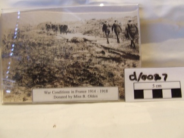
Photo France 1914-18
Sepia photo of conditions in France 1914-18label War Conditions in France donated by Miss B Olsen -
 Lara RSL Sub Branch
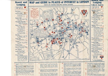
Map, Map of London
Map of London including Places of interest and Accommodation for Australian Navy, and Australian Imperial ForceMap given to Australian Navy and Imperial forces in London during WW1Map of London - YMCA - Place of Interest and Accommodation for Soldiers and Sailors in London 1917Map of London Rising Sun Badge Places of interest Accommodation for sailors and soldiers in Londonmap london ymca ww1 -
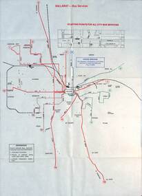 Ballarat Tramway Museum
Map - Public Transport Map - Bus, Ministry of Transport, Ballarat, Bendigo & Geelong, 1977
... maps ...Set of three maps, c1977 show the bus routes for each of Ballarat, Bendigo and Geelong along with railways. Provides information on each route, summary timetables, who operated the route and places of interest. Published by the Ministry of Transport in conjunction with the Transport Regulation Board, Bus Proprietors Association and VicRail. By comparison with the posters issued at the time of tram closure, can see the changes made to the routes in each city. See item 6813 for Ballarat, 6812 for Geelong, and 6814 for Bendigo.Demonstrates a public transport map published by the Ministry of Transport.Set of three 10 fold maps printed in colour to pocket size.On each map "7/77" in ink.buses, maps, ballarat, bendigo, geelong, timetables, railways -
 Bendigo Military Museum
Souvenir - SOUVENIR - Embroidered silk handkerchief holder, 1914-1918
Item sent home to "Dorrie" Elizabeth Dorothy Irene wood by her father, Private John Edward Wood 5239, 6th Battalion. Embarked 1/4/1916, killed in action 20/9/1917. No known grave. Name on the Menin Gate Panel 7, AWM Panel 49, Bendigo RSL Museum Roll of Honour. Headstone Eaglehawk Cemetery erected by his wife Ethel Irene Wood.Gold and green embroidered flowers on a blue silk fabric. Silk rope binding around its edges with knot on each corner. Cream silk on back and item is padded."Souvenir from France" embroidered in black/gold metal thread.souvenir, craft, textile, handkerchief holder