Showing 1502 items matching "handbook"
-
 Frankston RSL Sub Branch
Handbook, Service Book with Orders of Service, Hymns, Psalms, Etc
A hard cover printed handbook authorised for use by the Australian Military Forces. The cover is coloured blue and is inscribed with black lettering. This is a publication providing the Order for a Combined Parade Service for general use at Chuch Parades of the AMF. The Order has been approved by the Chaplains-General of the Church of England and the Methodist, Presbyterian, and United Churches of the Commonwealth of Australia and is authorised to be used at Combined Parade Services.The cover inscription is "AA Book 33 Revised May '67". The full title is "SERVICE BOOK with ORDERS OF SERVICE, HYMNS, PSALMS, Etc., for use by members of the CHURCH OF ENGLAND IN AUSTRALIA and the members of the Churches comprising the PROTESTANT DENOMINATIONS". The cover also has the footnote "AUTHORISED FOR USE BY THE AUSTRALIAN MILITARY FORCES".military, australian military forces, church, chaplain, amf, church parade, church service -
Federation University Historical Collection
Handbook, The School Paper Grades V and VI Victoria Education Department, 1964-1966
Three handbooks with green patterns on recto and verso. Linen tape is on the spine. Paper is bound by string, connected at the top and bottom. .1)This handbook is a collection of The School Paper for grades V and VI, by the Victorian Education Department for 1964. It's contents are including by not limited to poetry and short stories submitted to the paper from a variety of authors such as "Beside the Road" by Louis H. Clark, information regarding the events of the time such as Air Force Commemoration Week, writings such as piece regarding self-control while using alcohol. and sheet music for various songs, such as "God save the queen". A history of Port Melbourne is included on page 2. A history of Australia's cattle trade is included on pages 11-12. In addition, A biography of Sid Kidman, Australia's "cattle king" is included between pages 36-37. .2)This handbook is a collection of The School Paper for grades V and VI, by the Victorian Education Department for 1965. It's contents are including by not limited to poetry and short stories submitted to the paper from a variety of authors, such as "Pit-Pony" by S.A. Bainbridge, information regarding the events of the time such as the Fig Harvest at El-Flaye, and sheet music for various songs, such as "Old John Braddleum". The short story "The ANZACS at Gallipoli" includes a photograph of James Simpson Kirkpatrick with his donkey, bearing a wounded soldier (Page 33). A piece titled "A good-bye and a welcome" on pages 50-51 details the farewell to Alex McDonell, the director of Education for Victoria from 1960 to 1965, and the welcoming of Frederick H. Brooks as the new Director of Education in Victoria. A supplement is included in regards to "Scholarships and Allowances available for further education" for July 1965. A biography of Rudyard Kipling is on pages 103-105. A monthly series titled "The Seed from which they grew" detailed the history of some of Victoria's historical institutions: Victoria's Government House, The Royal Botanic Gardens, Victorian Railways, School Broadcasts, (Victorian) Public Libraries, The Forests Commission of Victoria, The Correspondence School, The Royal Mint, Her Majesty's Mail, Victoria Police, and Fire brigades. .3)This handbook is a collection of The School Paper for grades V and VI, by the Victorian Education Department for 1966. It's contents are including by not limited to poetry and short stories submitted to the paper from a variety of authors such as "The Emu" by Joan Wise, information regarding the events of the time such as Australian Literature Week, and sheet music for various songs, such as "Potatoes"'. "The Nation Builders" was a monthy series serialised in the paper about explorers who helped to found Australia, such as Matthew Flinders, Baron Sir Ferdinand Von Mueller, Patrick ("Paddy") Hannan, Charles Yelverton O'Connor, John Ridley, Thomas Sutcliffe Mort, Sir Sidney Kidman, Hugh Victor McKay,Robert Hoddle, and Charles Kingsford Smith. A supplement is included in regards to "Scholarships and Allowances available for further education" for July 1966..1) , "Grade 5 Classroom Copy" and "1964" recto. Pages 17, 32, 81, 97,113, 129 features the text "A.J. Mathieson".Page 49 has the text "Grades 5/6 Staff Copy A.J. Mathieson". Page 17 has tick marks on lower right hand corner. Registration number written on verso bounding as "11735.1" in pencil. .2)"Grade 5 Classroom Copy" and "1965" recto.Registration number written on verso bounding as "11735.2" in pencil. .3)"Classroom Copy", "1966", "5" and a black curved line in the middle of the page recto. Page 1 has "A.J. Mathieson" on the top right hand side in red marker. In the middle of Page 35, there is some text underlined, and the comment "Quote Governor King" in green ink.Registration number written on verso bounding as "11735.3" in pencil.1964, handbook, alex ball, victorian education department, school paper, grade v and vi, hymns, poetry, songs, short story, charles kingsford smith, 1965, 1966, matthew flinders, baron sir ferdinand von mueller, patrick hannan, paddy hannan, charles yelverton o'connor, john ridley, thomas sutcliffe mort, sir sidney kidman, hugh victor mckay, robert hoddle, james simpson kirkpatrick, alex mcdonell, frederick h. brooks, rudyard kipling, victorian government house,, royal botanic gardens, victorian railways, school broadcasts,, victorian public libraries, forests commission of victoria, correspondence school, royal mint, her majesty's mail, victoria police, fire brigades, port melbourne, sid kidman, cattle king, cattle trade -
 Mont De Lancey
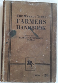
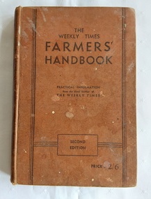
Book, Milshinock, The Weekly Times Farmers' Handbook, 1933
A handbook for farmers compiled from articles from practical information from the Rural Section of the Weekly Times in Australia. It has informed generations of farmers on the way of the land, with useful tips and invaluable advice. Few farms would have been without a well-thumbed copy.A brown hardcover book with the title printed in black text, The Weekly Times Farmer's Handbook. Compiled from the Farmers' Information Bureau with the publisher The Herald Press in a square underneath. Price - 2/6 at the bottom. Three black lines decorate both sides and across the Publisher section. Ink stains on the front. The spine has the faded title written. An index is at the back, along with advertising for farming products and equipment. 240p. Stains and foxing on the edges of the pages are visible. Some damage to the spine top and bottom.non-fictionA handbook for farmers compiled from articles from practical information from the Rural Section of the Weekly Times in Australia. It has informed generations of farmers on the way of the land, with useful tips and invaluable advice. Few farms would have been without a well-thumbed copy.farming australia, farming, the weekly times newspaper -
Federation University Historical Collection
Book - Handbooks, Monash University Handbooks, 1993-4
Federation University Australia was established on 1 January 2014. Formerly known as the University of Ballarat, its enabling legislation was the University of Ballarat Amendment (Federation University Australia) Act 2013. Although formally created as a University in 1994, the University of Ballarat had a lineage back to 1870 with the establishment of the School of Mines Ballarat, making it the third institution of higher learning to be established in Australia and the first to be established in regional Australia. On 1 January 1994, Ballarat University College became the University of Ballarat and in 1998 the University merged with three TAFE Institutes to become a dual sector institution with multiple campuses. On 1 January 2014, the University of Ballarat amalgamated with the Monash University Gippsland Campus to form Federation University Australia. The Gippsland Campus also had a long lineage dating back to 1928 with the establishment of the Yallourn Technical School which became a predecessor institution to the Gippsland College of Advanced Education formed in 1968. In 1990, it was renamed the Monash University College and in 1993 became the Gippsland Campus of Monash University. Federation University Australia, or FedUni, is Australia’s newest public University. Headquartered in Ballarat, Victoria, the University offers programs in Higher Education and Vocational Education and Training to regional Victoria and beyond. The University’s commitment to educational and social equity, teaching excellence, research distinction, environmental sustainability and regional capacity building has enabled it to develop in a way that draws on its proud heritage to inform its future. Its regional character sets a framework for the University’s priorities but does not constrain it from serving wider community interests, nationally and internationally. With campuses from Horsham in the west of the state, to Churchill in the east, the name Federation University Australia was chosen to convey the scope and capacity of an expanded regional university with a federated network of campuses contributing to a new and different Australian university.20 handbooks relating to subjects offered by Monash University in 1993-4. .1) Monash University Arts Handbook 1993 (red cover) .2) Monash University Arts Graduate Handbook 1994 (red cover) .3) Monash University Art & Design Handbook 1994 (red cover) .4) Monash University Engineering Handbook 1993 (brown cover) .5) Monash University Engineering Handbook 1994 (brown cover) .6) Monash University Education Handbook 1993 (yellow cover) .7) Monash University Education Handbook 1994 (yellow cover) .8) Monash University Economics Commerce & Management Handbook Handbook 1993 (blue cover) .9) Monash University Computing & Information Technology Handbook 1995 (green cover) .10) Monash University Business Handbook 1993 (red cover) .11) Monash University Business 7 Economics Handbook 1994 (mid blue) .12) Monash University Professional Studies Handbook 1993 (purple cover) .13) Monash University Science Handbook 1993 (green cover) .14) Monash University Science Handbook 1994 (green cover)monash university, gippsland campus, medicine, law, pharmacy, nursing, education, handbook -
 Melbourne Tram Museum
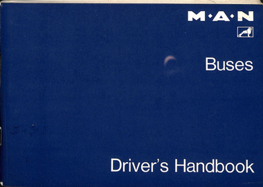
Manual, MAN, "MAN Buses - Driver's Handbook" and, "Gearbox flaw cripples bus fleet", mid 1980's
.1 - Manual - 116 pages centred stapled - titled "MAN Buses - Driver's Handbook". Has a table of contents, item reference list and electric circuit diagrams. Covers the operation, equipment, driving, cold weather operation, maintenance, lubrication, fuels, general car and maintenance. .2 - newspaper clipping from The Age ""Gearbox flaw cripples bus fleet", dated 26/3/1987, by Tony Harrington, Transport Reporter reporting on the withdrawal of 20 buses from North Fitzroy - replacement parts no longer being manufactured. Also has a loose note about the radiator capacity.trams, tramways, buses, maintenance, man, manual, gears -
 Melbourne Tram Museum
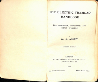
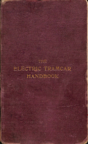
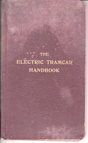
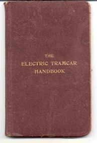
Book, W. A. Agnew, "The Electric Tramcar Handbook", 1915
Book - six sections, 134 pages + end pages + heavy card covered with a red stippled paper titled "The Electric Tramcar Handbook", 7th Edition, written by W. A. Agnew, published by H. Alabaster, Gatehouse & Co. Ludgate Hill in 1915. Right hand of sheets rounded. Has a table of contents and index at the rear. Written for Motormen, Inspectors and depot workers. Covers many aspects of the electric circuits for trams, including controller diagrams, tramways, tramcars, controllers, overhead, brakes, on the road and faults and Breakdowns. Would have been a reference guide for training staff. Scanned in three pdf files.trams, tramways, electrical engineering, electrical equipment, air compressors, brakes, instructions, maintenance, tramcars, training, controllers, overhead -
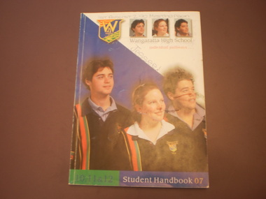
 Wangaratta High School
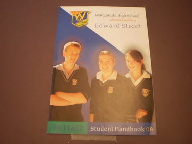
WHS Student Handbook, 2008
Paperback WHS student handbook with large colour image of three WHS students. There is a WHS logo in the top left corner and a blue and white pattern in the background.Wangaratta High School 10,11 & 12 Student Handbook 08 individual pathways Edward Street -
 Mont De Lancey
Book, Milshinock, The Weekly Times Farmers' Handbook, c 1940's
A handbook for farmers compiled from articles from practical information from the Rural Section of the Weekly Times in Australia. It has informed generations of farmers on the way of the land, with useful tips and invaluable advice. Few farms would have been without a well-thumbed copy.A brown hardcover book with the title printed in black text, The Weekly Times Farmers' Handbook on the front cover. Compiled from the Farmers' Information Bureau with Practical Information from the Rural Section of The Weekly Times. Second Edition is printed in a black rectangular shape at the bottom with the price - 2/6. Three black lines decorate both sides and across the cover information. Ink stains on the front. The spine has the faded title written. The title page is missing, but there remains A Forward and Preface. An index is at the back, along with advertising for farming products and equipment. Diagrams, illustrations are included. 286Pp. Stains and foxing on the edges of the pages are visible. Some damage to the spine top and bottom.non-fictionA handbook for farmers compiled from articles from practical information from the Rural Section of the Weekly Times in Australia. It has informed generations of farmers on the way of the land, with useful tips and invaluable advice. Few farms would have been without a well-thumbed copy.farming australia, the weekly times, farmers -
 Glen Eira Historical Society
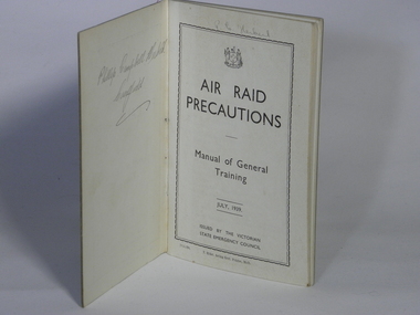
Booklet, Handbook, Victorian State Emergency Council, Air Raid Precautions - Manual of General Training - July 1939, July 1939
Air Raid Precautions organisations were established in each state in Australia during World War 2. Air Raid Precautions in Victoria were run by Civil Defense organisation. This handbook, one of a series of handbooks, used in Caulfield during World War 2.Represents the importance of air raid wardens to civilian defence to handle the threat posed thus officials issued instructions on what to do in case of an air raid. This handbook was used for the Air Raid Precautions in Caulfield during World War 2.Printed handbook has 66 pages bound in soft cover of heavy weight buff colour with red spine.On front cover contains Victoria coat of arms, stamped with 'Caulfield Historical Society' in top right hand corner, handwritten in pen '64' and in pencil 'Box 4/1'. Also includes number '7155/39' On inside cover, in pencil, 'Phillip Campbell Hubert' and on first page, in pencil, 'P.C.Hubert' air raid precautions, general training, july 1939 -
Federation University Historical Collection
Book, Ballarat School of Mines and Industries Handbook, 2004, 2004
The Ballarat School of Mines was a predecessor institution of Federation University. It was established in 1870 through initiatives of the Ballarat Mining Board which felt there was a need for such a institution because of the declining number of mine managers for the goldfields. Classes i Surveying, Mathematics and Chemistry began in 1871. With the decline in goldmining in the early part of the century, the direction of the College changed and broadened. The Art School was established in 1907, and in 1912 trade classes commenced in carpentry, fitting and turning, plumbing and telegraphy. In 1913 the Ballarat Junior Technical School became part of SMB. In 1970 the tertiary sector of the college was formed and became Ballarat College of Advanced Education when it separated from SMB in 1976. In the same year SMB became a regional College of Technical and Further Education (TAFE).White two ringed folder with an image of the Ballarat School of Mines on the cover. It contains a history of the Ballarat School of Mines and Industries, courses, apprenticeships, and further information. handbook, ballarat school of mines, trades, apprentices, tafe, ron sutton, julie schmock, ann mccaffrey, alister heighway, david flintoft, mary molloy, mark bevelander, rocky hazlett, colin mccurry -
 National Vietnam Veterans Museum (NVVM)
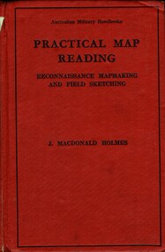
Booklet, MacDonald Holmes, J, Practical Map Rreading: Reconnaissance Mapmaking And Field Sketching, 1941
A red cardboard cover with a black line around the perimater. Top of the booklet reads Australian Military Handbooks with the title under this. Middle of the handbook reads J. MacDonald Holmeshandbook, australian military6, practical map reading, reconnaissance mapmaking, field sketching -
 Ballarat Tramway Museum
Book, W.A. Agnew, "The Electric Tramcar Handbook", 1905
Book titled "The Electric Tramcar Handbook written by W.A. Agnew. Book has dark red cloth covers, gold block titled on front only, with tipped in end papers, title page, contents pages, three introductory pages by author, 110 pages of text, five index pages and two folded sheets interspersed in book with wiring or controller diagrams. Book finished with red tinted edging. Has a index at the rear of the book. Book published by The Electrical Review Limited, London in 1905, 2nd edition. Primary contents chapters include: The Electric Circuit Electric Tramways Electric Tramcars Controllers Brakes On the Road Faults and Breakdowns. See also Reg Item 2247 for the 8th Edition.Numerous price or wage calculations on inside of rear cover.trams, tramways, tramcars, tramways, technical books, handbooks -
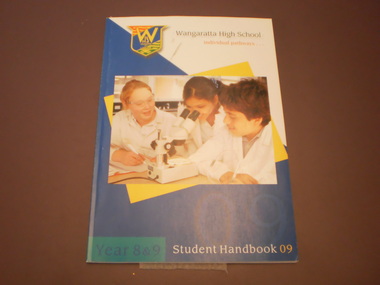 Wangaratta High School
WHS Student Handbook, 2009
paperback WHS Student handbook with large colour image of three WHS students in lab coats looking at a microscope with a WHS logo in the top left corner and a blue, white and yellow pattern in the background.Wangaratta High School Year 9 & 9 Student Handbook 09 individual pathways... -
 Melbourne Tram Museum
Book, The Electrical Review Limited, "The Electric Tramcar Handbook", 1920
Book titled "The Electric Tramcar Handbook" written by W.A. Agnew. Book has dark red cloth covers, gold block titled on front only, with tipped in end papers, title page, contents pages, three introductory pages by author, 127 pages of text, five index pages and six folded sheets interspersed in book with wiring or controller diagrams. Book finished with red tinted edging. Book published by The Electrical Review Limited, London in 1920, 8th edition. On the inside front cover has the stamp of the Australian Electric Traction Association and office stamp of "The Melbourne Electric Supply Company Limited" which has been crossed out. Primary contents chapters include: The Electric Circuit Electric Tramways Electric Tramcars Controllers Brakes On the Road Faults and Breakdowns.See images i2 and i3 showing notes and AETA stamp and MESCo stamp.trams, tramways, tramcars, tramways, technical books, handbooks, mesco -
 Warrnambool and District Historical Society Inc.
Book, Fletcher Jones Handbook, 1951
This booklet has been produced as a handbook for the employees of the Warrnambool-based clothing business of Fletcher Jones and Staff. Sir David Fletcher Jones (1895-1977) was born in Bendigo and served with the A.I.F. in World War One. He and an ex-war mate began trading in the Western District as itinerant hawkers of manchester and later Fletcher Jones continued on his own, gradually expanding the business until, in 1922, he opened a menswear and tailoring business in Warrnambool. By 1941 he was making nothing but men’s trousers, supplying retailers in over 100 outlets. In the late 1940s he turned his business into a Co-Operative and later expanded the business to include both men’s and women’s clothing. He opened a factory in Warrnambool, which, with it beautiful gardens, became a tourist attraction. The factory site was called Pleasant Hill. When he died in 1977 his business was one of the largest clothing manufacturers in Australia and possibly the world but, with the competition from imported clothing, the enterprise did not survive into the 21st century. It is presumed that Doug Ferguson was an employee of Fletcher Jones and that the gold label award was for his work or that of his department. This staff handbook for employees of the clothing business of Fletcher Jones & Staff is of major interest as this business, known nationally, was one of the most significant businesses ever to operate in Warrnambool. The handbook is of interest in itself as it has the Fletcher Jones logo, interesting material about the business philosophy of the business and Fletcher Jones himself, an autographed photograph of him and some significant photographs of the business, including indoor photographs of the factory.This is a soft cover book of 14 pages. It has a blue cover with the red and gold badge of Fletcher Jones on the front cover. The first page has handwritten material in black ink and a photograph of Fletcher Jones. There is also a gold label stuck on to the first page. There are many black and white photographs scattered throughout the text. ‘Presentation Copy. This copy is the property of Doug Ferguson, Pleasant Hill, With Best Wishes Fletcher Jones, Dec. 20 1951.’ Gold stamp: ‘Highest Award Cut, Make & Trim’ fletcher jones and staff, doug ferguson, history of warrnambool -
 8th/13th Victorian Mounted Rifles Regimental Collection
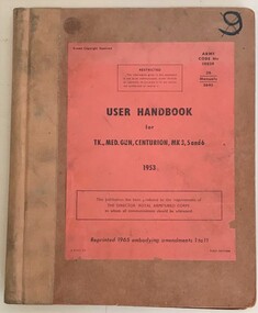
Book - Centurion tank handbook
8/13 Victorian Mounted Rifles was equipped with Centurion tanks 1955-59 and 1967-72.Hard cover booklet containing " User Handbook for Tk Med Gun Centurion Mk 3, 5 and 6"tank, centurion, handbook -
 Melbourne Tram Museum
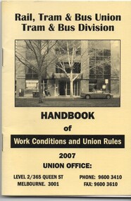
Poster, Rail Tram & Bus Union (RTBU), “RTBU Handbook of Work Conditions and Union Rules”, 2007
Book - 28 pages including manila coloured light card cover, centre stapled, titled “RTBU Handbook of Work Conditions and Union Rules”, published by the Rail Tram and Bus Union, Tram & Bus Division in 2007. Gives details of the Union Management - (see Key associations), delegates, a brief history of the tramway union, full garment of uniforms for new members, male and female, tram crews, officers and infrastructure workers, the do's an don'ts and classifications. Has a photo of the Union Management and delegates in the then new conference room - new offices in Queen St. Sponsored by the Austral Credit Union, Transport Health, Holding and Redlich with adverts for these companies and the RTBU Tramway Holiday units at Rosebud, Mile Jolly & Associates (Accountants), Consultum financial advisors, and the Retired Tramway Employee's Association of Victoria with contact details. 2nd copy added 26/6/2017 from donation of Ron Scholten.trams, tramways, rtbu, unions, handbooks -
 Glen Eira City Council History and Heritage Collection
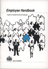
Employee Handbook
This Employee Handbook booklet from September 1992 contains information relevant for employees of the Caulfield City Council at the time. It contains a wide range of information pertaining to council staff, including a section to fill in an employees name, personal details, and emergency contacts, as well as insights into staff expectations, conduct, salaries, council organisation, general welfare and safe work practices. City of Caulfield Employee Handbook, dated September 1992. -
 Ballarat Tramway Museum
Book, W.A. Agnew, "The Electric Tramcar Handbook", 1920
Book titled "The Electric Tramcar Handbook written by W.A. Agnew. Book has dark red cloth covers, gold block titled on front only, with tipped in end papers, title page, contents pages, three introductory pages by author, 127 pages of text, five index pages and six folded sheets interspersed in book with wiring or controller diagrams. Book finished with red tinted edging. Book published by The Electrical Review Limited, London in 1920, 8th edition. On inside end paper, has ESCo Ballarat office stamp with date 30/9/1924, a glued in white sheet of paper with handwritten notation "To be returned to Mr. P. Bath Motorman No. 51, City Office 9.1.63" and on bottom left hand corner a "Tait Book Co. 90 William St. Melbourne" label that has also been glued in. Primary contents chapters include: The Electric Circuit Electric Tramways Electric Tramcars Controllers Brakes On the Road Faults and Breakdowns. See above for inside end paper.trams, tramways, tramcars, tramways, technical books, handbooks -
 Eltham District Historical Society Inc
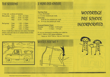
Folder, Woodridge Pre School Incorporated, 1993-2001
Contents: 1. Brochure: Woodridge Pre School Incorporated, 1997 2. Woodridge Pre-school 4 Year Old Handbook, 1999 3. Woodridge Pre-school Information Handbook 4 Year Old Program, c.2001 4. Letter: Sheryl Garbutt M.P., Member for Bundoora, 24 June 1993 about funding cuts to preschools 5. Newsclipping: Children dress up to mark kinder's 21st birthday, Diamond Valley News, 11 September 1996 6. Newsclipping: Preschool history plea, Diamond Valley Leader, 22 June 2005, p14 7. Newsclipping: Variety appeals to Kim, Diamond Valley Leader, 13 August 2008 8. Newsclipping: Preschoolers plant seeds of eductaion; My Kinder, Kylie Peckham, Diamond Valley Leader, 8 September 2010, p33 9. Newsclipping: Long-time school volunteer honoured; My Kinder, Sarah Ross, Diamond Valley Leader, 14 March 2012, p 23jenny macklin mp, kim brodribb, woodridge pre-school, steve herbert mp, sheryl garbutt mp -
NMIT (Northern Melbourne Institute of TAFE)
Handbook - CCOT, Collingwood College of Technical and Further Education Handbooks 1982, 1983, 1988, 1989, 1982-1983
The Handbook for Collingwood College of Technical and Further Education outlines the courses available and lists some staff and others associated with the school in each year. Individual volumes from 1982-1983, 1988, 1989. Collingwood Technical School was renamed Collingwood Technical College in 1972 and Collingwood College of Technical and Further Education in 1982.The official record of CCoT courses for the years 1982-1983.Individual annual volumes. Paperback. Each volume contains handbook for that year.The official record of CCoT courses for the years 1982-1983. Also 1988, 1989X2.collingwood college of technical and further education, collingwood technical college, handbooks, prospectus, nmit, -
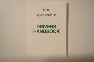 Melbourne Tram Museum
Booklet - PTC Road Vehicle Drivers Handbook, Public Transport Corporation (PTC), c.1990s
Handbook for PTC road vehicle drivers. The booklet contains important information for drivers concerning multiple aspects of operating a motor vehicle (e.g., buses).Instructional publication belonging to a now-superceded transit agency (since the 1990s). Likely well-used by staff of said agency.A small off-white booklet printed with green text. The front cover reads "P.T.C./ROAD VEHICLE/DRIVERS/HANDBOOK."public transport corporation, public transport, buses, drivers, driver training -
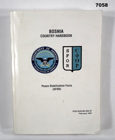 Bendigo Military Museum
Book - HANDBOOK, BOSNIA COUNTRY, USA Dept of Defence, Peace Stabilisation Force (SFOR), Feb 1991
Item in the collection re Craig Triffett. Refer Cat No. 5997.5 for his service details.This is a thick pocket size handbook. White cardboard cover. The title on front cover is in black ink - “Bosnia Country Handbook". On the left centre is the circular crest of the USA Dept of Defense (sic). On the right side is a shield shape, with the letters SFOR printed in black ink on white and on the right side of the shield is cryllic =COOP. Black ink on blue. Inside are numerous chapters of text, photos of weapon and aircraft. Flags of various nations' and unit patches.bosnian war, handbook -
4th/19th Prince of Wales's Light Horse Regiment Unit History Room
Booklet, Hazell, Watson & Viney Ltd, War Gases Learn and Live, late 1930's or early 1940's
A soft covered illustrated handbook produced for the public, civil defence services and the home guard covering the nature of war gases, gas attacks, protection, first aid and gas detection tablePrice 6dhandbook, war gases -
 Wangaratta High School
WHS Student Handbook, 2007
Paperback student handbook with an image of three year 12 students on the front cover with a blue and white pattern, a WHS logo in the top left and portraits of the tree students along the top.Wangaratta High School 10,11 &12 Student Handbook 07 individual pathways... 1st August 2:00 Mrs Thorson Jessee! -
4th/19th Prince of Wales's Light Horse Regiment Unit History Room
Book, Truck 1-Ton CT Cargo 4x4 Humber Mk I - with winch, Feb 1953
Handbook for class of vehicle used by the Regiment Soft covered loose leaf (lace bound) provisional user handbook reprint incorporating amdts 1 to 5 for the Truck, 1 Ton, CT HumberWO Code No 17765handbook, truck, humber -
Whitehorse Historical Society Inc.
Document, Mitcham Technical School, 1984-87
List of Members of School Council 1984,1985,1986 and 1987 .List of Members of School Council 1984,1985,1986 and 1987 Staff Information Handbook Staff List 1986 and 1987 and Staff Duties School Council Sub-Committees 1987.List of Members of School Council 1984,1985,1986 and 1987 .mitcham technical school, hoskin, gordon -
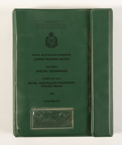 Beechworth RSL Sub-Branch
Pamphlet - Royal Australian Engineers Pocket Book - Special Techniques, 1992
Green vinyl handbook with a velcro opening, featuring a four-part ring binder that holds a paper notebook of written and illustrated information regarding weapons and practices. Front - ROYAL AUSTRALIAN ENGINEERS HANDBOOK / CORPS TRAINING NOTES / VOLUME 6 / SPECIAL TECHNIQUES / PAMPHLET NO 2 / ROYAL AUSTRALIAN ENGINEERS / POCKET BOOK / 1992 / (CTN RAE 6.2) Image - -
Port Melbourne Historical & Preservation Society
Artwork, other - Engraving, James Thomson, Port Melbourne Town Hall, 1885
Purchased on E-Bay from Jane Nicholas, who says the editor of the "Ïllustrated Handbook" states that the illustrations are taken from the "Sketcher" and the "Ïllustrated Australian News"."Port Melbourne Town Hall" - an imaginative engraving of the building which bears little resemblance, from the "Ïllustrated handbook of Victoria, Australia" prepared for the Colonial and Indian Exhibition in London. A page removed by the vendor.built environment - civic, port melbourne town hall -
 Warrnambool and District Historical Society Inc.
Booklet - Warrnambool Visitor's Handbooks 1979-2024, Collett, Bain and Gaspar, Printers, 1979-2014
This is a collection of eight Warrnambool Visitor handbooks produced between 1979 and 2014 by the City of Warrnambool Tourist Information Centre. They contain maps of Warrnambool, lists of services, accommodation and tourist attractions as well as many advertisements for local businesses.These handbooks give a useful snapshot of businesses and tourist attractions in Warrnambool for each of the years covered. (1979, 1980, 1986, 1990, 1993, 1994, 1995, 2014)[.1a] A 48 page booklet with white pages and blue printing. The front cover has a coloured photograph of Flagstaff Hill with boats on a man made lake in the foreground looking across Lake Pertobe toward South Warrnambool. [.1b] A coloured bifold brochure. The front cover has a fisherman on a cray-boat holding a crayfish in the lower section. The top quarter has a blue back ground with white printing. The rear cover is red and has small photos of the Hopkins River and the Framlingham Forest. [.2] A 48 page booklet with white pages and black printing. The front cover is white with black writing on the left hand side and a colour photograph of the Loch Ard peacock. The Warrnambool Premier Town stylised logo of seven Norfollk pines above blue waves is in the top right hand corner. There is a blank ink Warrnambool Library stamp underneath the logo. The rear cover has photographs of The Twelve Apostles and the Hopkins Falls and the Premier Town Logo [.3] A 40 page booklet with mainly black printing on white paper. There are three fold out maps of Warrnambool and the surrounding district. The glossy cover has a black background with a colour photograph of the Twelve Apostles taken at sunset. The rear cover has three small of Proudfoot's boathouse on the Hopkins River, Flagstaff Hill, and the main beach area. The front cover has black writing inside to peach coloured rectangles. The inside rear cover has a fold out coloured tour map of Western Victoria. [.4] A 40 page booklet printed on glossy white paper with coloured photographs and black and red printing. The front cover has a photograph of The Twelve Apostles surrounded by a white border. There is red writing in the upper border. There is a sandy coloured writing superimposed across the bottom of the photograph and a Victoria's Shipwreck Coast logo in the bottom right hand corner. [.5] A 44 page booklet printed on white paper with black printing. The cream coloured cover has a pale red rectangle with blue writing on the right hand facing edge and includes two stylised Norfolk pines and with waves underneath. There is is an intersecting blue rectangle with cream printing. [.6] A 48 page booklet printed on white paper with black printing. The cover is brown with a cream vertical strip containing black writing on the right hand side. There is a stylised map from Geelong to Mount Gambier showing the Great Ocean Road across the cover. [.7] A 48 page booklet printed on white paper with black print. The glossy colour cover has a photograph of a Southern Right whale fluke. There is white printing on a the blue background of the sky and sea. The bottom left hand side of the front cover has a Tourism Victoria logo made of jigsaw puzzle pieces. The back cover has a stylised coloured map of The Great Ocean Road located in a white rectangle at the top of the page. Within the rectangle is a small map of Australia locating Victoria and the part of Victoria covered by the map. [.8] A 64 page A5 coloured booklet printed on white pages with black print. The white front cover has black and grey print with a colour photograph of two people holding coffee cups watching four race horses being exercised on the beach and in the water of Lady Bay in the early morning. The bottom right hand corner has a Tourism Victoria logo. The rear cover has a mainly blue back ground with a pink orange and green colour splats contains words advertising the 2015 Fun 4 Kids Festival [.1a] Warrnambool The Heart of Victoria's Great Southwest Visitor's Handbook [.1b] Warrnambool City for all seasons; The Heart of Victoria's Great Southwest [.2] Warrnambool visitor's handbook Warrnambool Premier Town 1979-1982 [.3] Warrnambool Handbook Victoria [.4] Warrnambool The Shipwreck Coast [.5] Welcome to Warrnambool Warrnambool Visitors Handbook 1993-1994 [.6] Welcome to Warrnambool Visitors Handbook 1994-95 Rear cover: Warrnambool Centre of Victoria's Shipwreck Coast on Australia's Great Ocean Road [.7] Warrnambool Shipwreck Coast - Great Ocean Road; You'll love every piece of Victoria; Visitors Handbook [.8] Warrnambool Great Ocean Road Official Visitor Guide; It's a wonderful Warrnambool; You'll love every piece of Victoria visitvictoria.com. Rear Cover Live entertainment.Workshops.Creativity.Action 28 June - 5 July 2015 Australia's Best Children's Festival F4K The ultimate winter school holiday adventure Fun 4 kids festival Warrnambool For more information visit Fun4kids.com.au Warrnambool great Ocean Road Victoriawarrnambool, visitor handbooks, tourist information guides, warrnambool maps