Showing 938 items
matching heritage places
-
 Glen Eira Historical Society
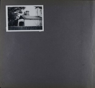
Album - Album page, Myoora, 405 Alma Road, Circa 1972
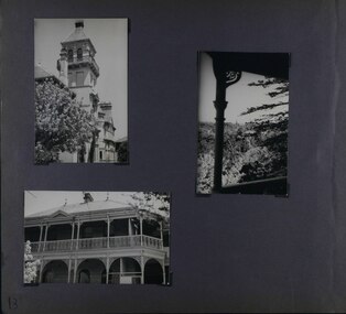
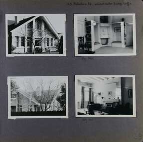
This photograph is part of the Caulfield Historical Album 1972. This album was created in approximately 1972 as part of a project by the Caulfield Historical Society to assist in identifying buildings worthy of preservation. The album is related to a Survey the Caulfield Historical Society developed in collaboration with the National Trust of Australia (Victoria) and Caulfield City Council to identify historic buildings within the City of Caulfield that warranted the protection of a National Trust Classification. Principal photographer thought to be Trevor Hart, member of Caulfield Historical Society. Most photographs were taken between 1966-1972 with a small number of photographs being older and from unknown sources. All photographs are black and white except where stated, with 386 photographs over 198 pages.Victorian Heritage Register (VHR) Number H0490 From the Victorian Heritage Register Database - Citation for Myoora https://vhd.heritagecouncil.vic.gov.au/places/275 (as at 6/10/2020) Myoora, 405 Alma Road, North Caulfield, was designed by Reed, Henderson & Smart and can be attributed to Anketell Henderson. It was built in 1886 and 1887 for Thomas Christian, who had founded the fabled gold mine, the Day Dawn at Charters Towers. He never occupied the house although his widow lived there for some time. The house was subdivided into three and later six flats. Myoora was one of many large mansions on broad acres with gardens in Caulfield. Perhaps the grandest was Labassa. The mansions date from the 1850s through to the late 1890s. The siting of Myoora on a ridge influenced its planning and composition. A central hall and corridor along the ridge is entered from the centre of the more formal north facade. The entrance is marked by an elaborately detailed tower. A stair turret provides a second accent. The western end of the building is completed by a massively detailed chimney as the service wing. The south facade enjoyed an outlook to port phillip from a two-storey cast iron verandah. Bay windows, chimneys, the tower and the turret and minor details are brought together in a sophisticated asymmetrical composition. This is reflected in the planning. The asymmetry of Myoora pivoting on the tower is the most notable feature of the building. The walls are built of cement rendered brick. The cement render has not been painted. The roof is slate. The balconies and verandah are cast iron. The footings and cellar are bluestone. The architectural firm Reed, Henderson & Smart was very prominent in Victoria in the nineteenth century. Anketell Henderson was an eminent and well respected member of the profession. He worked successfully in London and interstate as well as in Victoria. They were better known for commercial and public buildings. Myoora is an important private commission. The style of Myoora is a combination of details from the Continental and English Renaissance through the boom style and the Queen Anne style. There is also an early influence from the American Romanesque style especially in the stair turret. The latter style was important at the turn of the century and Myoora is a significant precursor. Other buildings of a similar scale survive in Caulfield and elsewhere. Labassa, the most fabulous, is quite different stylistically as are most of the other comparable mansions. Stonnington is perhaps closer but relies on different details from the Queen Anne style and lacks any American influence. For its historical associations through its owners and architects, for its style and composition and for its intactness, Myoora is significant at a State level. The craftmanship of Myoora is what could be expected of a building of the time and type. It is relatively intact and in fair condition. The main staircase has been removed, minor alterations to decorative features have occurred and additions have been made to the exterior.Page 13 of Photograph Album including three black and white photographs. Two of the photos are in a portrait orientation and arranged in the top half of the page. The other photo in landscape orientation is towards the left on the bottom section of the page.Handwritten: 13 [bottom left]caulfield north, trevor hart, alma road, mansion, myoora, tower, thomas christian, 1880's, queen anne, cement rendered brick, unpainted, balconies, verandahs, anketell henderson, continental and english renaissance, american romanesque, cast iron balconies, views, cast iron work, reed henderson & smart, flats, gardens, asymmetrical style, slate roofs -
 Glen Eira Historical Society
Album - Album page, Myoora, 405 Alma Road, Circa 1972
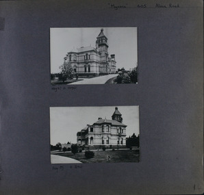
This photograph is part of the Caulfield Historical Album 1972. This album was created in approximately 1972 as part of a project by the Caulfield Historical Society to assist in identifying buildings worthy of preservation. The album is related to a Survey the Caulfield Historical Society developed in collaboration with the National Trust of Australia (Victoria) and Caulfield City Council to identify historic buildings within the City of Caulfield that warranted the protection of a National Trust Classification. Principal photographer thought to be Trevor Hart, member of Caulfield Historical Society. Most photographs were taken between 1966-1972 with a small number of photographs being older and from unknown sources. All photographs are black and white except where stated, with 386 photographs over 198 pages.Victorian Heritage Register (VHR) Number H0490 From the Victorian Heritage Register Database - Citation for Myoora https://vhd.heritagecouncil.vic.gov.au/places/275 (as at 6/10/2020) Myoora, 405 Alma Road, North Caulfield, was designed by Reed, Henderson & Smart and can be attributed to Anketell Henderson. It was built in 1886 and 1887 for Thomas Christian, who had founded the fabled gold mine, the Day Dawn at Charters Towers. He never occupied the house although his widow lived there for some time. The house was subdivided into three and later six flats. Myoora was one of many large mansions on broad acres with gardens in Caulfield. Perhaps the grandest was Labassa. The mansions date from the 1850s through to the late 1890s. The siting of Myoora on a ridge influenced its planning and composition. A central hall and corridor along the ridge is entered from the centre of the more formal north facade. The entrance is marked by an elaborately detailed tower. A stair turret provides a second accent. The western end of the building is completed by a massively detailed chimney as the service wing. The south facade enjoyed an outlook to port phillip from a two-storey cast iron verandah. Bay windows, chimneys, the tower and the turret and minor details are brought together in a sophisticated asymmetrical composition. This is reflected in the planning. The asymmetry of Myoora pivoting on the tower is the most notable feature of the building. The walls are built of cement rendered brick. The cement render has not been painted. The roof is slate. The balconies and verandah are cast iron. The footings and cellar are bluestone. The architectural firm Reed, Henderson & Smart was very prominent in Victoria in the nineteenth century. Anketell Henderson was an eminent and well respected member of the profession. He worked successfully in London and interstate as well as in Victoria. They were better known for commercial and public buildings. Myoora is an important private commission. The style of Myoora is a combination of details from the Continental and English Renaissance through the boom style and the Queen Anne style. There is also an early influence from the American Romanesque style especially in the stair turret. The latter style was important at the turn of the century and Myoora is a significant precursor. Other buildings of a similar scale survive in Caulfield and elsewhere. Labassa, the most fabulous, is quite different stylistically as are most of the other comparable mansions. Stonnington is perhaps closer but relies on different details from the Queen Anne style and lacks any American influence. For its historical associations through its owners and architects, for its style and composition and for its intactness, Myoora is significant at a State level. The craftmanship of Myoora is what could be expected of a building of the time and type. It is relatively intact and in fair condition. The main staircase has been removed, minor alterations to decorative features have occurred and additions have been made to the exterior.Page 14 of Photograph Album including two black and white photographs that are arranged in landscape orientation in the centre of the page with one beneath the other. Handwritten: "Myoora" 405 Alma Road [top right] /Neg 87 c1890 [under top photo]/ Neg 89 c1890/ [under bottom photo]/ 14 [bottom right]caulfield north, trevor hart, alma road, mansion, myoora, tower, thomas christian, 1880's, queen anne, cement rendered brick, unpainted, balconies, verandahs, anketell henderson, continental and english renaissance, american romanesque, cast iron balconies, gardens, views, cast iron work, reed henderson & smart, flats, asymmetrical style, slate roofs -
 Glen Eira Historical Society
Album - Album page, Myoora, 405 Alma Road, Circa 1972
This photograph is part of the Caulfield Historical Album 1972. This album was created in approximately 1972 as part of a project by the Caulfield Historical Society to assist in identifying buildings worthy of preservation. The album is related to a Survey the Caulfield Historical Society developed in collaboration with the National Trust of Australia (Victoria) and Caulfield City Council to identify historic buildings within the City of Caulfield that warranted the protection of a National Trust Classification. Principal photographer thought to be Trevor Hart, member of Caulfield Historical Society. Most photographs were taken between 1966-1972 with a small number of photographs being older and from unknown sources. All photographs are black and white except where stated, with 386 photographs over 198 pages.Victorian Heritage Register (VHR) Number H0490 From the Victorian Heritage Register Database - Citation for Myoora https://vhd.heritagecouncil.vic.gov.au/places/275 (as at 6/10/2020) Myoora, 405 Alma Road, North Caulfield, was designed by Reed, Henderson & Smart and can be attributed to Anketell Henderson. It was built in 1886 and 1887 for Thomas Christian, who had founded the fabled gold mine, the Day Dawn at Charters Towers. He never occupied the house although his widow lived there for some time. The house was subdivided into three and later six flats. Myoora was one of many large mansions on broad acres with gardens in Caulfield. Perhaps the grandest was Labassa. The mansions date from the 1850s through to the late 1890s. The siting of Myoora on a ridge influenced its planning and composition. A central hall and corridor along the ridge is entered from the centre of the more formal north facade. The entrance is marked by an elaborately detailed tower. A stair turret provides a second accent. The western end of the building is completed by a massively detailed chimney as the service wing. The south facade enjoyed an outlook to Port Phillip from a two-storey cast iron verandah. Bay windows, chimneys, the tower and the turret and minor details are brought together in a sophisticated asymmetrical composition. This is reflected in the planning. The asymmetry of Myoora pivoting on the tower is the most notable feature of the building. The walls are built of cement rendered brick. The cement render has not been painted. The roof is slate. The balconies and verandah are cast iron. The footings and cellar are bluestone. The architectural firm Reed, Henderson & Smart was very prominent in Victoria in the nineteenth century. Anketell Henderson was an eminent and well respected member of the profession. He worked successfully in London and interstate as well as in Victoria. They were better known for commercial and public buildings. Myoora is an important private commission. The style of Myoora is a combination of details from the Continental and English Renaissance through the boom style and the Queen Anne style. There is also an early influence from the American Romanesque style especially in the stair turret. The latter style was important at the turn of the century and Myoora is a significant precursor. Other buildings of a similar scale survive in Caulfield and elsewhere. Labassa, the most fabulous, is quite different stylistically as are most of the other comparable mansions. Stonnington is perhaps closer but relies on different details from the Queen Anne style and lacks any American influence. For its historical associations through its owners and architects, for its style and composition and for its intactness, Myoora is significant at a State level. The craftmanship of Myoora is what could be expected of a building of the time and type. It is relatively intact and in fair condition. The main staircase has been removed, minor alterations to decorative features have occurred and additions have been made to the exterior.Page 16 of Photograph Album including three black and white photographs. Two are arranged in landscape orientation on the right hand side of the page with the other photo in portrait mode on the left hand side. Handwritten: views from "Myoora" 405 Alma Road [top right] / Neg 181 Dec 1972 [under left side photo] / Neg 189 Dec 1972 [under bottom right photo] / 16 [bottom right]caulfield north, trevor hart, alma road, mansion, myoora, tower, thomas christian, 1880's, queen anne, cement rendered brick, unpainted, balconies, verandahs, anketell henderson, continental and english renaissance, american romanesque, cast iron balconies, panoramic views, streetscapes, cast iron work, reed henderson & smart, gardens, asymmetrical style, slate roofs, chimneys -
 Glen Eira Historical Society
Album - Album page, Myoora, 405 Alma Road, Circa 1972
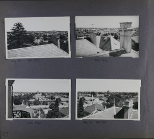
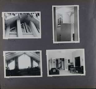
This photograph is part of the Caulfield Historical Album 1972. This album was created in approximately 1972 as part of a project by the Caulfield Historical Society to assist in identifying buildings worthy of preservation. The album is related to a Survey the Caulfield Historical Society developed in collaboration with the National Trust of Australia (Victoria) and Caulfield City Council to identify historic buildings within the City of Caulfield that warranted the protection of a National Trust Classification. Principal photographer thought to be Trevor Hart, member of Caulfield Historical Society. Most photographs were taken between 1966-1972 with a small number of photographs being older and from unknown sources. All photographs are black and white except where stated, with 386 photographs over 198 pages.Victorian Heritage Register (VHR) Number H0490 From the Victorian Heritage Register Database - Citation for Myoora https://vhd.heritagecouncil.vic.gov.au/places/275 (as at 6/10/2020) Myoora, 405 Alma Road, North Caulfield, was designed by Reed, Henderson & Smart and can be attributed to Anketell Henderson. It was built in 1886 and 1887 for Thomas Christian, who had founded the fabled gold mine, the Day Dawn at Charters Towers. He never occupied the house although his widow lived there for some time. The house was subdivided into three and later six flats. Myoora was one of many large mansions on broad acres with gardens in Caulfield. Perhaps the grandest was Labassa. The mansions date from the 1850s through to the late 1890s. The siting of Myoora on a ridge influenced its planning and composition. A central hall and corridor along the ridge is entered from the centre of the more formal north facade. The entrance is marked by an elaborately detailed tower. A stair turret provides a second accent. The western end of the building is completed by a massively detailed chimney as the service wing. The south facade enjoyed an outlook to port phillip from a two-storey cast iron verandah. Bay windows, chimneys, the tower and the turret and minor details are brought together in a sophisticated asymmetrical composition. This is reflected in the planning. The asymmetry of Myoora pivoting on the tower is the most notable feature of the building. The walls are built of cement rendered brick. The cement render has not been painted. The roof is slate. The balconies and verandah are cast iron. The footings and cellar are bluestone. The architectural firm Reed, Henderson & Smart was very prominent in Victoria in the nineteenth century. Anketell Henderson was an eminent and well respected member of the profession. He worked successfully in London and interstate as well as in Victoria. They were better known for commercial and public buildings. Myoora is an important private commission. The style of Myoora is a combination of details from the Continental and English Renaissance through the boom style and the Queen Anne style. There is also an early influence from the American Romanesque style especially in the stair turret. The latter style was important at the turn of the century and Myoora is a significant precursor. Other buildings of a similar scale survive in Caulfield and elsewhere. Labassa, the most fabulous, is quite different stylistically as are most of the other comparable mansions. Stonnington is perhaps closer but relies on different details from the Queen Anne style and lacks any American influence. For its historical associations through its owners and architects, for its style and composition and for its intactness, Myoora is significant at a State level. The craftmanship of Myoora is what could be expected of a building of the time and type. It is relatively intact and in fair condition. The main staircase has been removed, minor alterations to decorative features have occurred and additions have been made to the exterior.Page 17 of Photograph Album including four black and white photographs. All are arranged in landscape orientation with two on the top half of the page and the other two below.Handwritten: Neg 185 Dec 1972 [under top left photo] / Dec 1972 [under top right photo] / Dec 1972 [under bottom left photo] / Neg 153 Dec 1972 [under bottom right photo] / 17 [bottom left]caulfield north, trevor hart, alma road, mansion, myoora, tower, thomas christian, 1880's, queen anne, cement rendered brick, unpainted, balconies, verandahs, anketell henderson, continental and english renaissance, american romanesque, cast iron balconies, panoramic views, streetscapes, cast iron work, reed henderson & smart, gardens, asymmetrical style, slate roofs -
 Glen Eira Historical Society
Album - Album page, Myoora, 405 Alma Road, Circa 1972
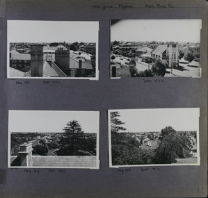
This photograph is part of the Caulfield Historical Album 1972. This album was created in approximately 1972 as part of a project by the Caulfield Historical Society to assist in identifying buildings worthy of preservation. The album is related to a Survey the Caulfield Historical Society developed in collaboration with the National Trust of Australia (Victoria) and Caulfield City Council to identify historic buildings within the City of Caulfield that warranted the protection of a National Trust Classification. Principal photographer thought to be Trevor Hart, member of Caulfield Historical Society. Most photographs were taken between 1966-1972 with a small number of photographs being older and from unknown sources. All photographs are black and white except where stated, with 386 photographs over 198 pages.Victorian Heritage Register (VHR) Number H0490 From the Victorian Heritage Register Database - Citation for Myoora https://vhd.heritagecouncil.vic.gov.au/places/275 (as at 6/10/2020) Myoora, 405 Alma Road, North Caulfield, was designed by Reed, Henderson & Smart and can be attributed to Anketell Henderson. It was built in 1886 and 1887 for Thomas Christian, who had founded the fabled gold mine, the Day Dawn at Charters Towers. He never occupied the house although his widow lived there for some time. The house was subdivided into three and later six flats. Myoora was one of many large mansions on broad acres with gardens in Caulfield. Perhaps the grandest was Labassa. The mansions date from the 1850s through to the late 1890s. The siting of Myoora on a ridge influenced its planning and composition. A central hall and corridor along the ridge is entered from the centre of the more formal north facade. The entrance is marked by an elaborately detailed tower. A stair turret provides a second accent. The western end of the building is completed by a massively detailed chimney as the service wing. The south facade enjoyed an outlook to port phillip from a two-storey cast iron verandah. Bay windows, chimneys, the tower and the turret and minor details are brought together in a sophisticated asymmetrical composition. This is reflected in the planning. The asymmetry of Myoora pivoting on the tower is the most notable feature of the building. The walls are built of cement rendered brick. The cement render has not been painted. The roof is slate. The balconies and verandah are cast iron. The footings and cellar are bluestone. The architectural firm Reed, Henderson & Smart was very prominent in Victoria in the nineteenth century. Anketell Henderson was an eminent and well respected member of the profession. He worked successfully in London and interstate as well as in Victoria. They were better known for commercial and public buildings. Myoora is an important private commission. The style of Myoora is a combination of details from the Continental and English Renaissance through the boom style and the Queen Anne style. There is also an early influence from the American Romanesque style especially in the stair turret. The latter style was important at the turn of the century and Myoora is a significant precursor. Other buildings of a similar scale survive in Caulfield and elsewhere. Labassa, the most fabulous, is quite different stylistically as are most of the other comparable mansions. Stonnington is perhaps closer but relies on different details from the Queen Anne style and lacks any American influence. For its historical associations through its owners and architects, for its style and composition and for its intactness, Myoora is significant at a State level. The craftmanship of Myoora is what could be expected of a building of the time and type. It is relatively intact and in fair condition. The main staircase has been removed, minor alterations to decorative features have occurred and additions have been made to the exterior.Page 18 of Photograph Album including four black and white photographs. All are arranged in landscape orientation with two on the top half of the page and the other two below.Handwritten: views from "Myoora" 405 Alma Road / [top right hand] / Neg 188 Dec 1972 [under top left photo] / Dec 1972 [under top right photo] / Neg 184 Dec 1972 [under bottom left photo] / Neg 168 Dec 1972 [under bottom right photo] / 18 [bottom right]caulfield north, trevor hart, alma road, mansion, myoora, tower, thomas christian, 1880's, queen anne, turret, cement rendered brick, unpainted, balconies, verandahs, anketell henderson, continental and english renaissance, american romanesque, cast iron balconies, panoramic views, streetscapes, cast iron work, reed henderson & smart, asymmetrical style, gardens, slate roofs -
 Glen Eira Historical Society
Album - Album page, Balaclava Road, 45, Circa 1972
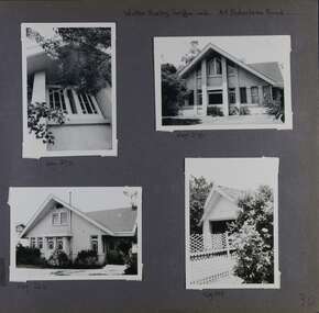
This photograph is part of the Caulfield Historical Album 1972. This album was created in approximately 1972 as part of a project by the Caulfield Historical Society to assist in identifying buildings worthy of preservation. The album is related to a Survey the Caulfield Historical Society developed in collaboration with the National Trust of Australia (Victoria) and Caulfield City Council to identify historic buildings within the City of Caulfield that warranted the protection of a National Trust Classification. Principal photographer thought to be Trevor Hart, member of Caulfield Historical Society. Most photographs were taken between 1966-1972 with a small number of photographs being older and from unknown sources. All photographs are black and white except where stated, with 386 photographs over 198 pages. While the page heading says "architect: Walter Burley Griffin", in fact Edward F. Billson designed it.From the Victorian Heritage Register Database - Citation for 45 Balaclava Road https://vhd.heritagecouncil.vic.gov.au/places/35562 (as at 12/10/2020) The house at 45 Balaclava Road, Caulfield North has architectural importance as an early example of the work of Edward F. Billson, whose work demonstrated the influence of the internationally distinguished American architect Frank Lloyd Wright and his one time colleague, Walter Burley Griffin with whom Billson worked in partnership for a period. It is presumed to be the earliest important example Billson's work and attains special importance as an early example of modern architecture in Australia, the earliest work of Griffin preceding it by only five years.Page 28 of Photograph Album with four photographs - two interior and two exterior photographs.Hand written: 45 Balaclava Rd architect Walter Burley Griffin [top right] / Neg 265 [under top right photo] / Neg 266 [under right bottom photo] / 28[bottom right]trevor hart, caulfield north, balaclava road, edward f. billson, frank lloyd wright, walter burley griffin, modern architecture, 1910's, gables, double storey houses, attics, windows -
 Glen Eira Historical Society
Album - Album page, Balaclava Road, 45, Circa 1972
This photograph is part of the Caulfield Historical Album 1972. This album was created in approximately 1972 as part of a project by the Caulfield Historical Society to assist in identifying buildings worthy of preservation. The album is related to a Survey the Caulfield Historical Society developed in collaboration with the National Trust of Australia (Victoria) and Caulfield City Council to identify historic buildings within the City of Caulfield that warranted the protection of a National Trust Classification. Principal photographer thought to be Trevor Hart, member of Caulfield Historical Society. Most photographs were taken between 1966-1972 with a small number of photographs being older and from unknown sources. All photographs are black and white except where stated, with 386 photographs over 198 pages. While the page heading says "architect: Walter Burley Griffin", in fact Edward F. Billson designed it.From the Victorian Heritage Register Database - Citation for 45 Balaclava Road https://vhd.heritagecouncil.vic.gov.au/places/35562 (as at 12/10/2020) The house at 45 Balaclava Road, Caulfield North has architectural importance as an early example of the work of Edward F. Billson, whose work demonstrated the influence of the internationally distinguished American architect Frank Lloyd Wright and his one time colleague, Walter Burley Griffin with whom Billson worked in partnership for a period. It is presumed to be the earliest important example Billson's work and attains special importance as an early example of modern architecture in Australia, the earliest work of Griffin preceding it by only five years.Page 29 of Photograph Album with four photographs of close up views of architectural details of a window and doors including three interiors and one exterior view.Hand written: Neg 263 [under top left photo] / Neg 269[under top right photo] / Neg 261 [under bottom left photo] / Neg 267 [under bottom right photo] / 29 [bottom left]trevor hart, caulfield north, balaclava road, edward f. billson, frank lloyd wright, walter burley griffin, modern architecture, 1910's, gables, double storey houses, windows -
 Glen Eira Historical Society
Album - Album page, Balaclava Road, 45, Circa 1972
This photograph is part of the Caulfield Historical Album 1972. This album was created in approximately 1972 as part of a project by the Caulfield Historical Society to assist in identifying buildings worthy of preservation. The album is related to a Survey the Caulfield Historical Society developed in collaboration with the National Trust of Australia (Victoria) and Caulfield City Council to identify historic buildings within the City of Caulfield that warranted the protection of a National Trust Classification. Principal photographer thought to be Trevor Hart, member of Caulfield Historical Society. Most photographs were taken between 1966-1972 with a small number of photographs being older and from unknown sources. All photographs are black and white except where stated, with 386 photographs over 198 pages. While the page heading says "Walter Burley Griffin arch", in fact Edward F. Billson designed it.From the Victorian Heritage Register Database - Citation for 45 Balaclava Road https://vhd.heritagecouncil.vic.gov.au/places/35562 (as at 12/10/2020) The house at 45 Balaclava Road, Caulfield North has architectural importance as an early example of the work of Edward F. Billson, whose work demonstrated the influence of the internationally distinguished American architect Frank Lloyd Wright and his one time colleague, Walter Burley Griffin with whom Billson worked in partnership for a period. It is presumed to be the earliest important example Billson's work and attains special importance as an early example of modern architecture in Australia, the earliest work of Griffin preceding it by only five years.Page 30 of Photograph Album with three photographs of the exterior of this double storey house and one photograph of a carport.Handwritten: Walter Burley Griffin arch. 45 Balaclava Road [top right] / Neg 272 [under top left photo] / Neg 270 [under top right photo] / Neg 262 [under bottom left photo] / Neg 264 [under bottom right photo] / 30 [bottom right] trevor hart, caulfield north, balaclava road, edward f. billson, frank lloyd wright, walter burley griffin, modern architecture, 1910's, gables, double storey houses, windows, attics, carports, gardens -
 Glen Eira Historical Society
Album - Album page, Halstead, Bambra Road, Circa 1972
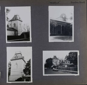
This photograph is part of the Caulfield Historical Album 1972. This album was created in approximately 1972 as part of a project by the Caulfield Historical Society to assist in identifying buildings worthy of preservation. The album is related to a Survey the Caulfield Historical Society developed in collaboration with the National Trust of Australia (Victoria) and Caulfield City Council to identify historic buildings within the City of Caulfield that warranted the protection of a National Trust Classification. Principal photographer thought to be Trevor Hart, member of Caulfield Historical Society. Most photographs were taken between 1966-1972 with a small number of photographs being older and from unknown sources. All photographs are black and white except where stated, with 386 photographs over 198 pages.From the Victorian Heritage Register Database - Citation for Halstead, 23 Bambra Road as at (as at 12/10/2020) https://vhd.heritagecouncil.vic.gov.au/places/276 Halstead is believed to be the oldest standing residence in Caulfield constructed in 1857 with subsequent additions during the 19th Century. The house was built for and owned by James Dickson, a stock agent, until his death in 1880. Although on a much reduced parcel of land, Halstead is one of the few remaining remnants of Caulfield when it was an area of mansion houses occupied by town residing squatters, professional and business men. It is important for its place in the socio-economic history of south eastern suburban Melbourne, the inland pattern of development stretching from Malvern through Murrumbeena. Architecturally the single storey building displays a history of alteration and addition. Its main front presents with a single storey cast iron verandah across the full width, including the two pavilion wings at each end. Located towards the rear on the Halstead Street side is the substantial three storey tower with its Mansard roof and cast-iron balustrade which makes the house clearly visible from Halstead Street and Bambra Road. Because of internal alteration the importance of the building relates to the exterior only of the main house. Halstead is believed to be the oldest standing residence in the city of Caulfield. https://vhd.heritagecouncil.vic.gov.au/places/43645 "Halstead" is regionally important as a surviving large villa from the early Victorian (1850's) period, offering insights into the lifestyles of the privileged in Caulfield at that time. The later tower is of architectural interest for its use of Medieval Romanesque enrichment.Page 32 of Photograph Album with four photographs of the exterior of this double storey house, focussing on different angles for the house's tower.Hand written: "Halstead" Bambra Road [top right] / 32 [bottom right] trevor hart, caulfield north, bambra road, 1850's, halstead, james dickson, mansion, villa residence, cast iron verandah, pavillion wings, halstead street, victorian, tower, balustrading, decorative brackets, mansard roof, brick, cast iron, slate roof, curved windows, single storey mansions, streetscapes, medieval romanesque style, slate roofs, gardens, cast iron work -
 Glen Eira Historical Society
Album - Album page, Halstead, Bambra Road, Circa 1972
This photograph is part of the Caulfield Historical Album 1972. This album was created in approximately 1972 as part of a project by the Caulfield Historical Society to assist in identifying buildings worthy of preservation. The album is related to a Survey the Caulfield Historical Society developed in collaboration with the National Trust of Australia (Victoria) and Caulfield City Council to identify historic buildings within the City of Caulfield that warranted the protection of a National Trust Classification. Principal photographer thought to be Trevor Hart, member of Caulfield Historical Society. Most photographs were taken between 1966-1972 with a small number of photographs being older and from unknown sources. All photographs are black and white except where stated, with 386 photographs over 198 pages.From the Victorian Heritage Register Database - Citation for Halstead, 23 Bambra Road as at (as at 12/10/2020) https://vhd.heritagecouncil.vic.gov.au/places/276: Halstead is believed to be the oldest standing residence in Caulfield constructed in 1857 with subsequent additions during the 19th Century. The house was built for and owned by James Dickson, a stock agent, until his death in 1880. Although on a much reduced parcel of land, Halstead is one of the few remaining remnants of Caulfield when it was an area of mansion houses occupied by town residing squatters, professional and business men. It is important for its place in the socio-economic history of south eastern suburban Melbourne, the inland pattern of development stretching from Malvern through Murrumbeena. Architecturally the single storey building displays a history of alteration and addition. Its main front presents with a single storey cast iron verandah across the full width, including the two pavilion wings at each end. Located towards the rear on the Halstead Street side is the substantial three storey tower with its Mansard roof and cast-iron balustrade which makes the house clearly visible from Halstead Street and Bambra Road. Because of internal alteration the importance of the building relates to the exterior only of the main house. Halstead is believed to be the oldest standing residence in the city of Caulfield. https://vhd.heritagecouncil.vic.gov.au/places/43645: "Halstead" is regionally important as a surviving large villa from the early Victorian (1850's) period, offering insights into the lifestyles of the privileged in Caulfield at that time. The later tower is of architectural interest for its use of Medieval Romanesque enrichment.Page 33 of Photograph Album with one landscape photograph of the exterior of Halstead, taken from the street.Hand written: 33 [bottom left] trevor hart, caulfield north, bambra road, 1850's, halstead, james dickson, mansion, villa residence, cast iron verandah, pavillion wings, halstead street, victorian, tower, balustrading, decorative brackets, mansard roof, brick, slate roof, curved windows, single storey mansions, cast iron work, medieval romanesque style, slate roofs, gardens -
 Glen Eira Historical Society
Album - Album page, Kynaston now Kahlyn, Bambra Road, Circa 1972
This photograph is part of the Caulfield Historical Album 1972. This album was created in approximately 1972 as part of a project by the Caulfield Historical Society to assist in identifying buildings worthy of preservation. The album is related to a Survey the Caulfield Historical Society developed in collaboration with the National Trust of Australia (Victoria) and Caulfield City Council to identify historic buildings within the City of Caulfield that warranted the protection of a National Trust Classification. Principal photographer thought to be Trevor Hart, member of Caulfield Historical Society. Most photographs were taken between 1966-1972 with a small number of photographs being older and from unknown sources. All photographs are black and white except where stated, with 386 photographs over 198 pages.https://vhd.heritagecouncil.vic.gov.au/places/35575 From: Glen Eira Heritage Management Plan (1996) by Andrew Ward and Associates Significance: "Kynaston" is locally important as a large late Victorian villa residence, demonstrating something of the lifestyle to which a senior government bureaucrat could aspire during the late nineteenth century boom period. The design of the verandah, though defaced, is unusual in Caulfield and, therefore, important. A substantial late Victorian stuccoed Bool11 style villa residence with tower surmounting the entrance porch, fluted columns to the ground level verandah and parapeted balcony over, now built in with a sympathetic addition at the north-west corner. The principal rooms and staircase are intact and representative of the period.Page 34 of Photograph Album with two portrait photographs of exterior of Kynaston - 2 views highlighting the front of the mansionHand written: "Kynaston" now "Kahlyn" Bambra Road [top right] / 34 [bottom right] trevor hart, caulfield north, bambra road, 1850's, mansion, villa residence, cast iron verandah, victorian, decorative brackets, slate roof, curved windows, 1880's, kynaston, kynaston l murray, kahlyn private hospital, kahlyn, return verandah, enclosed verandah, cast iron work, double storey mansions, towers, balconies -
 Glen Eira Historical Society
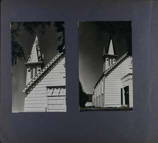
Album - Album page, St Mary's Anglican Church, Glen Eira Road, Circa 1972
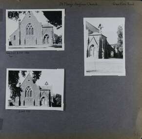
This photograph is part of the Caulfield Historical Album 1972. This album was created in approximately 1972 as part of a project by the Caulfield Historical Society to assist in identifying buildings worthy of preservation. The album is related to a Survey the Caulfield Historical Society developed in collaboration with the National Trust of Australia (Victoria) and Caulfield City Council to identify historic buildings within the City of Caulfield that warranted the protection of a National Trust Classification. Principal photographer thought to be Trevor Hart, member of Caulfield Historical Society. Most photographs were taken between 1966-1972 with a small number of photographs being older and from unknown sources. All photographs are black and white except where stated, with 386 photographs over 198 pages.From the Victorian Heritage Register Database - Citation for St Mary's Anglican Church https://vhd.heritagecouncil.vic.gov.au/places/43715 (as at 14/10/2020) St Mary's has architectural significance as a representative example of French influenced Low and Mixed Gothic (see stylistic Typology in National Trust's Historic Churches Study) and is further distinguished by its use of bluestone, entirely without relief. French influence is demonstrated by the high nave, apsidal sanctuary, spirelet and trumeau. The building is locally important as a historic focus for Anglican worship and early mission activity whilst its architectural grandeur is expressive of mid Victorian Caulfield's status as a suburban location for the Metropolis gentry.Page 56 of Photograph Album with three exterior photographs (two portrait and one landscape) of St Mary's Anglican Church.Hand written: St Mary's Anglican Church Eira Road [top right] / Neg 235 8 Oct 1966 [under top left photo] / 3 Sep 1972 [under bottom left photo] / 56 [bottom right] trevor hart, 1880's, elsternwick, glen eira road, st kilda east, church of england, gothic, st mary's, bluestone, apsidal sanctuary, spirelet, trumeau, anglican, 1870's, caulfield north, french-influenced low and mixed gothic style -
 Glen Eira Historical Society
Album - Album page, St Mary's Church Hall, Glen Eira Road, Circa 1972
... Victoria’s Jubilee. Victorian Heritage Database https ...This photograph is part of the Caulfield Historical Album 1972. This album was created in approximately 1972 as part of a project by the Caulfield Historical Society to assist in identifying buildings worthy of preservation. The album is related to a Survey the Caulfield Historical Society developed in collaboration with the National Trust of Australia (Victoria) and Caulfield City Council to identify historic buildings within the City of Caulfield that warranted the protection of a National Trust Classification. Principal photographer thought to be Trevor Hart, member of Caulfield Historical Society. Most photographs were taken between 1966-1972 with a small number of photographs being older and from unknown sources. All photographs are black and white except where stated, with 386 photographs over 198 pages. The Jubilee School on the corner of Hood Crescent and Glen Eira Road was built in 1887 AD to commemorate Queen Victoria’s Jubilee.Victorian Heritage Database https://vhd.heritagecouncil.vic.gov.au/places/43705 The former St Mary's Jubilee School is locally significant as an early purpose built church school, associated with St Mary's Church. Its use of polychrome brick is locally conspicuous whilst the adoption of the Gothic Style not only underlines its Christian foundations but relates to the comparable schools of the Public Works Department of the same period.Page 57 of Photograph Album with four exterior photographs (2 portrait and 2 landscape) of St Mary's Church Hall. Bottom right photograph is a photo of a photo.Hand written: St Mary's Church Hall - Glen Eira Road [top left] / Neg 233 8 Oct 1966 [under top left photo] / 3 Sept 1972 [under bottom left photo] / bottom right photo titled "St Mary's Sunday School" / 57 [bottom left] trevor hart, 1880's, elsternwick, glen eira road, st kilda east, church of england, st mary's, caulfield north, st mary's anglican church hall, hood crescent, jubilee school, polychrome brickwork, curved windows, church hall, queen victoria’s jubilee, victorian, sunday schools, st mary's jubilee school, gothic style -
 Glen Eira Historical Society
Album - Album page, Glenferrie Street, 4, Circa 1972
... at the State level is strengthened by its place as the home ...This photograph is part of the Caulfield Historical Album 1972. This album was created in approximately 1972 as part of a project by the Caulfield Historical Society to assist in identifying buildings worthy of preservation. The album is related to a Survey the Caulfield Historical Society developed in collaboration with the National Trust of Australia (Victoria) and Caulfield City Council to identify historic buildings within the City of Caulfield that warranted the protection of a National Trust Classification. Principal photographer thought to be Trevor Hart, member of Caulfield Historical Society. Most photographs were taken between 1966-1972 with a small number of photographs being older and from unknown sources. All photographs are black and white except where stated, with 386 photographs over 198 pages. From Glen Eira Heritage Management Plan 1996 by Andrew Ward: In 1905, most of portion 27 was vacant land, however Glenferrie Street had been formed and the land subsequently subdivided. In 1906, Robert Joseph Haddon, architect and painter, designed and built for his private residence, a brick house on the west side. Haddon named the house "Anselm". Also built on the property were a garage and fibro cement studio. "Anselm" is architecturally important at the State level as a substantially intact, highly personalised and boldly expressed house expressive the Arts and Crafts movement and incorporating Art Nouveaux enrichment in a variety of forms, the use of ornamental terra cotta tiles to the comer tower being of special note. Its importance at the State level is strengthened by its place as the home of the noted architect and Melbourne's most influential exponent (Freeland, J.M., Architecture in Australia, p. 213) of the Art Nouveaux movement.https://vhd.heritagecouncil.vic.gov.au/places/4442 Victorian Heritage Register: What is significant? Anselm was designed by noted English born architect Robert Joseph Haddon(1866-1929) as his own house and constructed in 1906. A single storey Arts and Crafts influenced red brick house with attic, Anselm has a pyramidal slate roof with prominent chimney stacks. There is a octagonal corner tower with saucer shaped domed roof surmounted by a weather vane, and the tower has decorative terracotta panels immediately below the eaves line. The front door opens immediately into a large living or common room, screened from view by a timber and bottle glass screen. The large room was designed to function as a drawing and dining room. The house is rich with hand crafted details including door and window furniture, wrought iron gutter brackets, fireplaces (one with built in wood box), and fire tools. The interior decoration includes hand painted frieze of Port Phillip in the study, and a hand painted frieze of turbulent sea with sailing boats in the tiled bathroom. There is a small hand painted tile at the base of the tower which states ?This building was erected AD1906 from designs by Robt J Haddon FRIBA,Lond FRIVA Melb Architect?. He also designed an attic addition which was constructed in 1927. Anselm is substantially intact although the double casement window immediately to the south of the front door was originally circular....Page 60 of Photograph Album with three exterior photographs (one portrait and two landscape) of Anselm.Hand written: 4 Glenferrie Street [top right] / ANSELM 4 Glenferrie St [under top photo] / 60 [bottom right] trevor hart, anselm, art nouveaux, arts and crafts, tower, bay window, glenferrie street, robert joseph haddon, 1900's, terra cotta tiles, double storey, caulfield north, corner tower, gates, cast iron work -
 Glen Eira Historical Society
Album - Album page, Glenferrie Street, 4, Circa 1972
... at the State level is strengthened by its place as the home ...This photograph is part of the Caulfield Historical Album 1972. This album was created in approximately 1972 as part of a project by the Caulfield Historical Society to assist in identifying buildings worthy of preservation. The album is related to a Survey the Caulfield Historical Society developed in collaboration with the National Trust of Australia (Victoria) and Caulfield City Council to identify historic buildings within the City of Caulfield that warranted the protection of a National Trust Classification. Principal photographer thought to be Trevor Hart, member of Caulfield Historical Society. Most photographs were taken between 1966-1972 with a small number of photographs being older and from unknown sources. All photographs are black and white except where stated, with 386 photographs over 198 pages. From Glen Eira Heritage Management Plan 1996 by Andrew Ward: In 1905, most of portion 27 was vacant land, however Glenferrie Street had been formed and the land subsequently subdivided. In 1906, Robert Joseph Haddon, architect and painter, designed and built for his private residence, a brick house on the west side. Haddon named the house "Anselm". Also built on the property were a garage and fibro cement studio. "Anselm" is architecturally important at the State level as a substantially intact, highly personalised and boldly expressed house expressive the Arts and Crafts movement and incorporating Art Nouveaux enrichment in a variety of forms, the use of ornamental terra cotta tiles to the comer tower being of special note. Its importance at the State level is strengthened by its place as the home of the noted architect and Melboume's most influential exponent (Freeland, J.M., Architecture in Australia, p. 213) of the Art Nouveaux movement. Victorian Heritage Register https://vhd.heritagecouncil.vic.gov.au/places/4442 What is significant? Anselm was designed by noted English born architect Robert Joseph Haddon(1866-1929) as his own house and constructed in 1906. A single storey Arts and Crafts influenced red brick house with attic, Anselm has a pyramidal slate roof with prominent chimney stacks. There is a octagonal corner tower with saucer shaped domed roof surmounted by a weather vane, and the tower has decorative terracotta panels immediately below the eaves line. The front door opens immediately into a large living or common room, screened from view by a timber and bottle glass screen. The large room was designed to function as a drawing and dining room. The house is rich with hand crafted details including door and window furniture, wrought iron gutter brackets, fireplaces (one with built in wood box), and fire tools. The interior decoration includes hand painted frieze of Port Phillip in the study, and a hand painted frieze of turbulent sea with sailing boats in the tiled bathroom. There is a small hand painted tile at the base of the tower which states ?This building was erected AD1906 from designs by Robt J Haddon FRIBA,Lond FRIVA Melb Architect?. He also designed an attic addition which was constructed in 1927. Anselm is substantially intact although the double casement window immediately to the south of the front door was originally circular....Page 61 of Photograph Album with one exterior photograph (portrait) of Anselm.Hand written: 61 [bottom left] trevor hart, anselm, art nouveaux, arts and crafts, tower, bay window, glenferrie street, robert joseph haddon, 1900's, terra cotta tiles, double storey, caulfield north, corner tower, brick house, attics -
 Glen Eira Historical Society
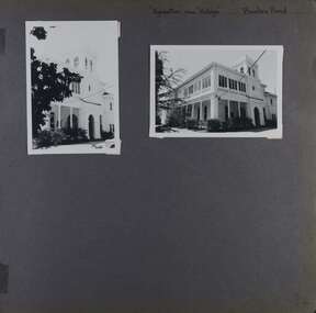
Album - Album page, Booran Road, 30, Circa 1972
... , Proud, Future and Lord. Victorian Heritage Register https ...This photograph is part of the Caulfield Historical Album 1972. This album was created in approximately 1972 as part of a project by the Caulfield Historical Society to assist in identifying buildings worthy of preservation. The album is related to a Survey the Caulfield Historical Society developed in collaboration with the National Trust of Australia (Victoria) and Caulfield City Council to identify historic buildings within the City of Caulfield that warranted the protection of a National Trust Classification. Principal photographer thought to be Trevor Hart, member of Caulfield Historical Society. Most photographs were taken between 1966-1972 with a small number of photographs being older and from unknown sources. All photographs are black and white except where stated, with 386 photographs over 198 pages. From Glen Eira Heritage Management Plan 1996 by Andrew Ward: In 1888, John Leek, a trainer, owned Lot 15, measuring one and three quarter acres, in Booran Road, north side between Glen Eira and Neerim Roads. The land backed onto the Caulfield Racecourse Reserve. NAV was £45. In 1890 Leek built for his residence, a ten roomed brick house on the site. NAV was £200. Leek was the owner/trainer of "Ingliston" who won the Caulfield Cup in 1900. Upon the horse's death in 1901, Leek is understood to have defied tradition by spending £20 on boots for the "ragged urchins in Bourke Street" instead of "shouting" at the bar. By 1899, the property was owned and occupied by Alfred Merrill, a dentist and was known as "Andover". NA V had decreased to £ll0. By 1910, Leslie Macdonald, a gentleman had purchased the property and renamed it "Moidart". In 1910-11 Macdonald sold it to John Robertson. The property had extensive wood stables on its north-east boundary and several other outbuildings. The house continued to be described as "Brick, ten rooms" as it was in 1926 when it was owned and occupied by John Arthur, a managing director. The land measured la.2r.31p. and had a NAV of £235. Nine people lived there. In 1926, Arthur also owned the adjoining Lot 16. Other racehorses of note, known to have been stabled here include Sobar, Havelock, Proud, Future and Lord.Victorian Heritage Register https://vhd.heritagecouncil.vic.gov.au/places/13532 What is significant? Lord Lodge is a thoroughbred racehorse training complex adjacent to Caulfield Racecourse, established in 1890. The area immediately around the racecourse has been associated with horse racing activities and businesses servicing the industry since the development of the racecourse in late the 19th century. Lord Lodge was named by the present occupants after the champion racehorse Lord who was stabled there in the 1950s. In the early 20th century the property was known as 'Andover' and subsequently 'Moidart'. The site consists of a single storey brick Italianate villa, jockeys' quarters, stables and open day yards with direct access to Caulfield racecourse from the rear of the property. The villa of 10 rooms on bluestone foundations was constructed in 1890 by John Leek, a horse trainer who purchased the newly subdivided land in 1888. The house has many Victorian Italianate or Boom Style features although it is more modest than many villas of its style. It has an asymmetrical facade with a faceted bay window and a prominent central tower with low pitch pyramidal roof that provides a clear view of the racecourse. Other characteristic features include stilted segmented arches, bracketed eaves, stucco wall finish and cast cement ornamentation. A room has been added on the north-facing verandah in sympathetic style and finish. Internally the rooms are substantially intact with original marble fireplaces and intricate ceiling roses and cornices. An entrance toward the rear of the southern side of the house is said to be where the stable hands, jockeys and other staff lined up for their meals. In the southeast corner of the property, backing directly on to Caulfield racecourse, is a substantial late Victorian timber stable, probably constructed in the 1890s but first appearing on the property title in 1910. The stable has 12 stalls, a loft and brick pavement and jerkin head roof form with varnished pine-lined ceiling carried on a chamfered timber frame. It has an original roof lantern. The doors of the stalls are not the original sliding doors but swing doors obtained from a barn at Epsom Racecourse in Mordialloc prior to demolition. Outside the gambrel roof has fretted barges but the building is otherwise utilitarian. Timber throughout the stalls has been worn by chewing and rubbing of horses over the century of its use. In the southern half of the property are open day yards where the racehorses are kept during the day. The red brick, single storey jockeys' quarters to the rear of the villa were probably built around 1950. A small brick, possibly late Victorian structure on the eastern boundary thought to have originally been a gardening shed, has been converted to a stable of two stalls. Modern concrete brick stables fill the northeast portion of the property. At the front of the property two Moreton Bay Figs (Ficus macrophylla), probably planted in the late 19th century, provide shade for horses in the day yards. In the 1890s John Leek sold the property, relocating his training facility to one of the newly established racecourses at Mentone or Mordialloc (Epsom). By 1899, the property was owned and occupied by Alfred Merrill, a dentist, who named the property 'Andover'. In 1910 it was purchased by Leslie McDonald, a gentleman, and renamed 'Moidart'; sold in 1910-1911 to John Robertson; and again in 1926 to John Arthur, a racehorse owner. The Victorian Amateur Turf Club purchased the property in the late 1930s and since this time has been leased to racehorse trainers. It is unclear whether the property operated as a training facility between 1899 - 1926. Several notable trainers and jockeys are associated with Lord Lodge. The best known is Arthur 'Scobie' Breasley, Australia's most successful jockey who was apprenticed to trainer Pat Quinlan at Lord Lodge (then 'Moidart') from 1928 - 1935. Breasley rode winners of the Caulfield Cup in four successive years 1942-45 and again in 1952. John Leek, the original owner of Lord Lodge trained Ingliston, the 1900 Caulfield Cup winner. Along with 'Lord' a number of well known racehorses including Sobar, Havelock, Proud and Future were trained at Lord Lodge .....Page 40 of Photograph Album with three landscape photographs of the exterior of this house.Handwritten: 30 Booran Road [top right hand corner] / 40 [bottom right]trevor hart, jenny o'donnell, booran road, mansion, caulfield east, ingliston, sobar, havelock, proud, future, lord, andover, moidart, lord lodge, grace darling, caulfield racecourse reserve, victorian amateur turf club, historic buildings register, national estate register, caulfield cup, horses, stables, horse racing, racehorses, outbuildings, racehorse trainers, depression, 1890s, brick houses, mansions, towers, verandahs, stained glass, italianate style, victorian style, architectural features, architectural styles, john leek, leslie macdonald, john arthur, john robertson, alfred merrill, jenny odonnell -
 Glen Eira Historical Society
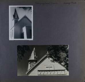
Album - Album page, Congregational Church, Grange Road, Circa 1972
This photograph is part of the Caulfield Historical Album 1972. This album was created in approximately 1972 as part of a project by the Caulfield Historical Society to assist in identifying buildings worthy of preservation. The album is related to a Survey the Caulfield Historical Society developed in collaboration with the National Trust of Australia (Victoria) and Caulfield City Council to identify historic buildings within the City of Caulfield that warranted the protection of a National Trust Classification. Principal photographer thought to be Trevor Hart, member of Caulfield Historical Society. Most photographs were taken between 1966-1972 with a small number of photographs being older and from unknown sources. All photographs are black and white except where stated, with 386 photographs over 198 pages. This church has since become the Greek Orthodox Church. From Victorian Heritage Database: Citation for Greek Orthodox Church HO84 https://vhd.heritagecouncil.vic.gov.au/places/43587 (as at 19/10/2020) The former Primitive Methodist, later Congregational, church at 152 Grange Road, Glenhuntly, is a small timber building, erected in 1885 (89?) in South Melbourne and relocated to Glenhuntly in 1909. It is a highly individual picturesque timber structure with distinctive spire and timber enrichment. It has aesthetic, historical and social significance. Its aesthetic value is derived from the choice of materials and picturesque Gothic Revival character showing American influence. Its historical value is derived from its survival as a rare example of a Primitive Methodist Church building whilst its social value hinges on its early roles as a place of worship for the Primitive Methodists in South Melbourne and the Congregationalists in Glenhuntly.Page 72 of Photograph Album with two photographs (one portrait and one landscape) of the upper exterior and tower of the Congregational Church on Grange RoadHand written: Congregational Church, Grange Road [top right] / 72 [bottom right] trevor hart, congregational church, grange road, gothic revival, carnegie, glen huntly, glenhuntly, greek orthodox church, primitive methodist church, spire, timber buildings -
 Glen Eira Historical Society
Album - Album page, Congregational Church, Grange Road, Circa 1972
This photograph is part of the Caulfield Historical Album 1972. This album was created in approximately 1972 as part of a project by the Caulfield Historical Society to assist in identifying buildings worthy of preservation. The album is related to a Survey the Caulfield Historical Society developed in collaboration with the National Trust of Australia (Victoria) and Caulfield City Council to identify historic buildings within the City of Caulfield that warranted the protection of a National Trust Classification. Principal photographer thought to be Trevor Hart, member of Caulfield Historical Society. Most photographs were taken between 1966-1972 with a small number of photographs being older and from unknown sources. All photographs are black and white except where stated, with 386 photographs over 198 pages. This church has since become the Greek Orthodox Church. From Victorian Heritage Database: Citation for Greek Orthodox Church HO84 https://vhd.heritagecouncil.vic.gov.au/places/43587 (as at 19/10/2020) The former Primitive Methodist, later Congregational, church at 152 Grange Road, Glen Huntly, is a small timber building, erected in 1885 (89?) in South Melbourne and relocated to Glenhuntly in 1909. It is a highly individual picturesque timber structure with distinctive spire and timber enrichment. It has aesthetic, historical and social significance. Its aesthetic value is derived from the choice of materials and picturesque Gothic Revival character showing American influence. Its historical value is derived from its survival as a rare example of a Primitive Methodist Church building whilst its social value hinges on its early roles as a place of worship for the Primitive Methodists in South Melbourne and the Congregationalists in Glenhuntly.Page 73 of Photograph Album with two photographs (both portrait) of front and side views of the spire of the Congregational Church on Grange RoadHand written: 73 [bottom left] trevor hart, congregational church, grange road, gothic revival, carnegie, glen huntly, glenhuntly, greek orthodox church, primitive methodist church, spire, timber buildings -
 Glen Eira Historical Society
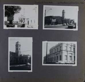
Album - Album page, Caulfield Town Hall cnr Hawthorn & Glen Eira Rds, Circa 1972
This photograph is part of the Caulfield Historical Album 1972. This album was created in approximately 1972 as part of a project by the Caulfield Historical Society to assist in identifying buildings worthy of preservation. The album is related to a Survey the Caulfield Historical Society developed in collaboration with the National Trust of Australia (Victoria) and Caulfield City Council to identify historic buildings within the City of Caulfield that warranted the protection of a National Trust Classification. Principal photographer thought to be Trevor Hart, member of Caulfield Historical Society. Most photographs were taken between 1966-1972 with a small number of photographs being older and from unknown sources. All photographs are black and white except where stated, with 386 photographs over 198 pages. Caulfield Town Hall is now known as Glen Eira Town Hall.From Victorian Heritage Database: Citation for Town Hall, Corner Glen Eira and Hawthorn Roads - HO106 https://vhd.heritagecouncil.vic.gov.au/places/43613 as at (19/10/2020) The former City of Caulfield (now City of Glen Eira) Municipal Offices, located at the south-west corner of Hawthorn and Glen Eira Roads, Caulfield South, were commenced for the Borough of Caulfield in 1884 when they also included a Post and Telegraph Office and Court of Petty Sessions. They were designed by the Borough surveyor, Sydney Smith. The hall was completed in 1890 to the design of Alexander Rankin and the present hall, foyer and portico completed to the design of Goldsmith and Jenkin, architects, in 1931. The complex is historically, aesthetically and socially significant. It is historically significant {Criterion A) as the centre of Local Government services in the area since 1885 and as a centre of post and telegraph and legal services for a period. Its association with architect and Borough surveyor, Sydney W. Smith is important in that the east elevation and facade (ground floor level only)as far west as the tower (lower two stages) survive as evidence of his work, the practice which his son continued after his death in 1886, becoming highly successful. The work of Goldsmith and Jenkin is historically important in that it indirectly demonstrates the growth of the City sustained during the Inter-war period, the work proceeding in spite of the Depression. It compares with other similar work of that time including the refurbishment of the Malvern Municipal Offices and Hall in 1927 (Hudson and Wardrop), the Melbourne Corporation Offices and Hall in 1925-28 (Stephenson and Meldrum, A. and K. Henderson) and the Camberwell Offices and Council Chamber in 1924 (Leighton Irwin and Roy Stevenson), other comparable municipal projects being undertaken during the 1930s. Finally, the Goldsmith and Jenkin works are important as a project of the Depression years organised specifically to alleviate unemployment problems in the Municipality. The complex is aesthetically important (Criterion E) as a prominent and imposing Classically derived complex of its type with individually noteworthy interior spaces being the entry hall and staircase, main Hall, Foyer and Council Chamber. The Adamesque plasterwork, timber panelling and furniture, Art Nouveaux enrichment and Classically derived treatment with sparing use of Australian decorative motifs are contributory elements. Exterior .elements of note include the remains of the original design prepared by Sydney Smith and the clock tower and portico which have come to symbolise important Municipal complexes erected prior to the Second World War. The complex is socially important (Criterion G) for the value placed on it by the community which has made use of it for activities including that of Local government for well over a century.Page 74 of Photograph Album with four photographs (three portrait and one landscape) of different views of the Caulfield Town Hall.Hand written: Caulfield Town Hall cnr Hawthorn & Glen Eira Rds [top right] / 74 [bottom right] trevor hart, caulfield, glen eira, caulfield town hall, sydney smith, sydney w smith, municipal, adamesque plasterwork, adamesque, art nouveaux, portico, council chambers, alexander rankin, foyer, local government, timber panelling, tower, unemployment, clock tower, hawthorn road, glen eira road, city of glen eira, municipal offices, post and telegraph office, goldsmith and jenkin, courthouses, surveyors, architects, classical architectural style, streetscapes, gardens, cars, glen eira town hall, depression 1929-1939 -
 Glen Eira Historical Society
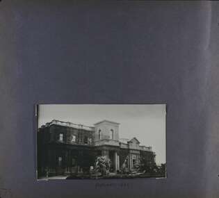
Album - Album page, Caulfield Town Hall cnr Hawthorn & Glen Eira Rds, Circa 1972
This photograph is part of the Caulfield Historical Album 1972 but is noted as taken in 1922. This album was created in approximately 1972 as part of a project by the Caulfield Historical Society to assist in identifying buildings worthy of preservation. The album is related to a Survey the Caulfield Historical Society developed in collaboration with the National Trust of Australia (Victoria) and Caulfield City Council to identify historic buildings within the City of Caulfield that warranted the protection of a National Trust Classification. Principal photographer thought to be Trevor Hart, member of Caulfield Historical Society. Most photographs were taken between 1966-1972 with a small number of photographs being older and from unknown sources. All photographs are black and white except where stated, with 386 photographs over 198 pages. Caulfield Town Hall is now known as Glen Eira Town Hall.From Victorian Heritage Database: Citation for Town Hall, Corner Glen Eira and Hawthorn Roads - HO106 https://vhd.heritagecouncil.vic.gov.au/places/43613 as at (19/10/2020) The former City of Caulfield (now City of Glen Eira) Municipal Offices, located at the south-west corner of Hawthorn and Glen Eira Roads, Caulfield South, were commenced for the Borough of Caulfield in 1884 when they also included a Post and Telegraph Office and Court of Petty Sessions. They were designed by the Borough surveyor, Sydney Smith. The hall was completed in 1890 to the design of Alexander Rankin and the present hall, foyer and portico completed to the design of Goldsmith and Jenkin, architects, in 1931. The complex is historically, aesthetically and socially significant. It is historically significant {Criterion A) as the centre of Local Government services in the area since 1885 and as a centre of post and telegraph and legal services for a period. Its association with architect and Borough surveyor, Sydney W. Smith is important in that the east elevation and facade (ground floor level only)as far west as the tower (lower two stages) survive as evidence of his work, the practice which his son continued after his death in 1886, becoming highly successful. The work of Goldsmith and Jenkin is historically important in that it indirectly demonstrates the growth of the City sustained during the Inter-war period, the work proceeding in spite of the Depression. It compares with other similar work of that time including the refurbishment of the Malvern Municipal Offices and Hall in 1927 (Hudson and Wardrop), the Melbourne Corporation Offices and Hall in 1925-28 (Stephenson and Meldrum, A. and K. Henderson) and the Camberwell Offices and Council Chamber in 1924 (Leighton Irwin and Roy Stevenson), other comparable municipal projects being undertaken during the 1930s. Finally, the Goldsmith and Jenkin works are important as a project of the Depression years organised specifically to alleviate unemployment problems in the Municipality. The complex is aesthetically important (Criterion E) as a prominent and imposing Classically derived complex of its type with individually noteworthy interior spaces being the entry hall and staircase, main Hall, Foyer and Council Chamber. The Adamesque plasterwork, timber panelling and furniture, Art Nouveaux enrichment and Classically derived treatment with sparing use of Australian decorative motifs are contributory elements. Exterior .elements of note include the remains of the original design prepared by Sydney Smith and the clock tower and portico which have come to symbolise important Municipal complexes erected prior to the Second World War. The complex is socially important (Criterion G) for the value placed on it by the community which has made use of it for activities including that of Local government for well over a century.Page 75 of Photograph Album with one portrait photograph of the exterior of Caulfield Town Hall taken in 1922.Hand written: FEBRUARY 1922 [under photo] / 75 [bottom left] trevor hart, caulfield, glen eira, caulfield town hall, sydney smith, sydney w smith, adamesque plasterwork, art nouveaux, portico, council chambers, alexander rankin, foyer, local government, timber panelling, tower, unemployment, clock tower, hawthorn road, glen eira road, city of glen eira, municipal offices, palms, gardens, post and telegraph offices, goldsmith and jenkin, architects, city of caulfield, ivy clad walls, surveyors, depression 1929-1939, glen eira town hall -
 Glen Eira Historical Society
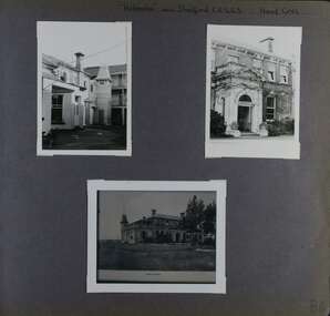
Album - Album page, Helenslea now Shelford CEGGS, Hood Crescent, Circa 1972
This photograph is part of the Caulfield Historical Album 1972. This album was created in approximately 1972 as part of a project by the Caulfield Historical Society to assist in identifying buildings worthy of preservation. The album is related to a Survey the Caulfield Historical Society developed in collaboration with the National Trust of Australia (Victoria) and Caulfield City Council to identify historic buildings within the City of Caulfield that warranted the protection of a National Trust Classification. Principal photographer thought to be Trevor Hart, member of Caulfield Historical Society. Most photographs were taken between 1966-1972 with a small number of photographs being older and from unknown sources. All photographs are black and white except where stated, with 386 photographs over 198 pages. The mansion has been the site of Shelford Church of England Girls’ Grammar School - now Shelford Girls’ Grammar School - since circa 1922.From Victorian Heritage Database citation for HO115: "Helenslea" 3 Hood Crescent, Caulfield North https://vhd.heritagecouncil.vic.gov.au/places/35212 as at 21/10/2020 ''Helenslea'' was built for Sir George Stephen, MLA, barrister and mining investor by 1863. It was built with an address to Glen Eira Road with the driveway gates close by the present Helenslea Road corner. The present address is no. 3 Hood Crescent, Caulfield North. It is historically, aesthetically and socially significant. It is historically significant (Criterion A) as the home of Sir George Stephen, MLA for Collingwood, barrister and mining investor and for its capacity to demonstrate Caulfield's early attraction as a residential retreat for Melbourne's eminent citizens. It is aesthetically significant (Criterion E) as a villa residence characteristic of the mid Victorian period, predating the use of cast iron and comparing in this respect with Charles Webb's "Farleigh" (1865) at 6 Farleigh Grove, Brighton. Its substantial nature causes it to be the earliest surviving mansion house in the Municipality. The porch, external austerity and opulent entrance hall and staircase are important contributory elements whilst the survival of the exterior surfaces predominantly in an unpainted state enhances its level of integrity. It is socially significant (Criterion G) for its association with Shelford C.E.G.G.S. since 1922. Page 86 of Photograph Album with three photographs (two portrait and one landscape ) of different views of Helenslea. One is a photo of a photograph.Handwritten: "Helenslea" now C.E.G.G.S Hood Cres [top right] / third photo is of a photograph titled "Shelford" / 86 [bottom right]trevor hart, hood crescent, helenslea, c.e.g.g.s., school, 1860's, sir george stephen, unpainted, mansion, shelford, villa residence, mid victorian, glen eira road, helenslea road, ceggs, porches, stairs, caulfield north, entrances, shelford church of england girls' grammar school, shelford girl's grammar, ivy -covered walls, caulfield -
 Glen Eira Historical Society
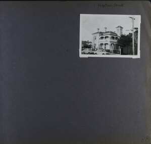
Album - Album page, Hopetoun Street, Circa 1972
This photograph is part of the Caulfield Historical Album 1972. This album was created in approximately 1972 as part of a project by the Caulfield Historical Society to assist in identifying buildings worthy of preservation. The album is related to a Survey the Caulfield Historical Society developed in collaboration with the National Trust of Australia (Victoria) and Caulfield City Council to identify historic buildings within the City of Caulfield that warranted the protection of a National Trust Classification. Principal photographer thought to be Trevor Hart, member of Caulfield Historical Society. Most photographs were taken between 1966-1972 with a small number of photographs being older and from unknown sources. All photographs are black and white except where stated, with 386 photographs over 198 pages.HO35 Hopetoun Private Hospital, Part of 2 - 6 Hopetoun Street in the City of Glen Eira From Victorian Heritage Database citation for Hopetoun Private Hospital https://vhd.heritagecouncil.vic.gov.au/places/43647 as at (21/10/2020) "Melrose" is of regional importance as a surviving and substantially intact example of a large villa residence designed by the noted Melbourne architect, Charles Webb. Its importance is enhanced by the use of unusually fine cast iron balustrading. As a surviving large villa designed by Charles Webb, it compares with his own home "Farleigh" (1865), in Brighton whilst the tower compares with his first home "Chilton" (c.l853)Page 88 of Photograph Album with one landscape photograph of a double storey mansion.Handwritten: Hopetoun Street [top right] / 88 [bottom left]trevor hart, elsternwick, hopetoun street, melrose, hospital, private hospital, victorian, charles webb, cast iron lacework, villa residence, tower, verandah, cars, curved windows, balcony, decorative brackets, cast iron work, mansions, architects -
 Glen Eira Historical Society
Album - Album page, Ripponlea, 192 Hotham Street, Circa 1972
This photograph is part of the Caulfield Historical Album 1972. This album was created in approximately 1972 as part of a project by the Caulfield Historical Society to assist in identifying buildings worthy of preservation. The album is related to a Survey the Caulfield Historical Society developed in collaboration with the National Trust of Australia (Victoria) and Caulfield City Council to identify historic buildings within the City of Caulfield that warranted the protection of a National Trust Classification. Principal photographer thought to be Trevor Hart, member of Caulfield Historical Society. Most photographs were taken between 1966-1972 with a small number of photographs being older and from unknown sources. All photographs are black and white except where stated, with 386 photographs over 198 pages.From Victorian Heritage Database citation for Rippon Lea H0614 https://vhd.heritagecouncil.vic.gov.au/places/427(as at 23/10/2020) Rippon Lea was commenced in 1868 by Frederick Sargood, a most successful politician and merchant. He was born in England in 1834 and arrived in Melbourne in 1850. He soon joined his father's wholesale soft goods firm, spending some time as its manager on the goldfields. Sargood entered the Legislative Council in 1874. He was Victoria's first Minister for Defence in 1883. Sir Frederick Sargood was created CMG. In 1885 and KCMG in 1890 as a reward for his contribution to public life. He died suddenly in 1903. Rippon Lea was designed by the leading firm of architects, Reed and Barnes. Joseph Reed had travelled in Europe in 1863, including northern Italy. When he returned he introduced the use of polychromy. While not the first examples, Rippon Lea and the Independent Church in Collins Street were the best and set a fashion which became a distinctly Melbourne style, particularly used for houses and churches. Its popularity was possible because of the new availability of different coloured bricks. Reed's fine Lombardic Romanesque details soon became debased by others. As Sargood's family grew and his fortunes prospered, Rippon Lea was extended to include 33 rooms - a complete mansion. The cast iron porte cochere and the northern conservatory were added in 1897. The architects were Taylor and Fitts. The ballroom was added in 1882 and remodelled in 1889. Many alterations have changed the interior and exterior during the ownerships of Benjamin Nathan and later his daughter Mrs Louisa Jones in the 1930s and are in their own right of significance. Sir Thomas Bent owned the property from 1903 until 1911 but never lived there. He subdivided much of the land. The original garden dates from about 1868, and it seems that William Guilfoyle of the Botanic Gardens was involved. It was redesigned in a more natural style in the 1880s by Sargood and his head gardener, Adam Anderson. The lake, waterfalls, fernery, hill and grotto are balanced by mighty deciduous trees and conifers. These are interspersed with, but never dominated by Australian species such as eucalyptus and other exotics. The sinuous drive with its carefully prepared approach to the house is notable. The original vegetable gardens, orchard and outer paddocks no longer survive. The shade house is important as the largest known in Australia and possibly the world. Its curved plan and form of construction are particularly notable. It was built about 1884.Page 90 of Photograph Album with five photographs (one landscape and 4 portrait) of Ripponlea - two different views of the front entrance to the mansion, one of the front gates and two different views of the main residence.Handwritten: "Ripponlea" 192 Hotham Street [top right] / North [under top left photo] / Neg 255 Dec 1972 MAIN DRIVE [under bottom left photo] / Neg 238 8 OCT 1966 [under middle right photo] / 88 [bottom right]trevor hart, elsternwick, mansion, hotham street, frederick sargood, reed and barnes, cast iron porte cochere, conservatory, 1860's, 1890's, ballroom, 1880's, benjamin nathan, louisa jones, thomas bent, sir thomas bent, william guilfoyle, adam anderson, lake, grotto, shade house, portico, ripponlea, victorian, sir frederick sargood, architects, polychrome bricks, lombardic romanesque architectural style, rippon lea, taylor and fitts, land subdivisions, gardens, drives, vegetable gardens, orchards -
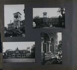 Glen Eira Historical Society
Album - Album page, Ripponlea, 192 Hotham Street, Circa 1972
This photograph is part of the Caulfield Historical Album 1972. This album was created in approximately 1972 as part of a project by the Caulfield Historical Society to assist in identifying buildings worthy of preservation. The album is related to a Survey the Caulfield Historical Society developed in collaboration with the National Trust of Australia (Victoria) and Caulfield City Council to identify historic buildings within the City of Caulfield that warranted the protection of a National Trust Classification. Principal photographer thought to be Trevor Hart, member of Caulfield Historical Society. Most photographs were taken between 1966-1972 with a small number of photographs being older and from unknown sources. All photographs are black and white except where stated, with 386 photographs over 198 pages.From Victorian Heritage Database citation for Rippon Lea H0614 https://vhd.heritagecouncil.vic.gov.au/places/427(as at 23/10/2020) Rippon Lea was commenced in 1868 by Frederick Sargood, a most successful politician and merchant. He was born in England in 1834 and arrived in Melbourne in 1850. He soon joined his father's wholesale soft goods firm, spending some time as its manager on the goldfields. Sargood entered the Legislative Council in 1874. He was Victoria?s first Minister for Defence in 1883. Sir Frederick Sargood was created CMG. In 1885 and KCMG in 1890 as a reward for his contribution to public life. He died suddenly in 1903. Rippon Lea was designed by the leading firm of architects, Reed and Barnes. Joseph Reed had travelled in Europe in 1863, including northern Italy. When he returned he introduced the use of polychromy. While not the first examples, Rippon Lea and the Independent Church in Collins Street were the best and set a fashion which became a distinctly Melbourne style, particularly used for houses and churches. Its popularity was possible because of the new availability of different coloured bricks. Reed's fine Lombardic Romanesque details soon became debased by others. As Sargood's family grew and his fortunes prospered, Rippon Lea was extended to include 33 rooms - a complete mansion. The cast iron porte cochere and the northern conservatory were added in 1897. The architects were Taylor and Fitts. The ballroom was added in 1882 and remodelled in 1889. Many alterations have changed the interior and exterior during the ownerships of Benjamin Nathan and later his daughter Mrs Louisa Jones in the 1930s and are in their own right of significance. Sir Thomas Bent owned the property from 1903 until 1911 but never lived there. He subdivided much of the land. The original garden dates from about 1868, and it seems that William Guilfoyle of the Botanic Gardens was involved. It was redesigned in a more natural style in the 1880s by Sargood and his head gardener, Adam Anderson. The lake, waterfalls, fernery, hill and grotto are balanced by mighty deciduous trees and conifers. These are interspersed with, but never dominated by Australian species such as eucalyptus and other exotics. The sinuous drive with its carefully prepared approach to the house is notable. The original vegetable gardens, orchard and outer paddocks no longer survive. The shade house is important as the largest known in Australia and possibly the world. Its curved plan and form of construction are particularly notable. It was built about 1884.Page 91 of Photograph Album with four photographs (two portrait and two landscape) of various external views of Ripponlea.Handwritten: SOUTH [under top left photo] / SOUTH [under top right photo] / WEST [under bottom left photo] / 91 [bottom left]trevor hart, elsternwick, mansion, hotham street, frederick sargood, reed and barnes, cast iron porte cochere, conservatory, 1860's, 1890's, ballroom, 1880's, benjamin nathan, louisa jones, thomas bent, sir thomas bent, william guilfoyle, adam anderson, lake, grotto, shade house, portico, ripponlea, victorian, sir frederick sargood, architects, taylor and fitts, rippon lea, polychrome bricks, lombardic romanesque style -
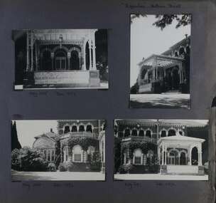 Glen Eira Historical Society
Album - Album page, Ripponlea, Hotham Street, Circa 1972
This photograph is part of the Caulfield Historical Album 1972. This album was created in approximately 1972 as part of a project by the Caulfield Historical Society to assist in identifying buildings worthy of preservation. The album is related to a Survey the Caulfield Historical Society developed in collaboration with the National Trust of Australia (Victoria) and Caulfield City Council to identify historic buildings within the City of Caulfield that warranted the protection of a National Trust Classification. Principal photographer thought to be Trevor Hart, member of Caulfield Historical Society. Most photographs were taken between 1966-1972 with a small number of photographs being older and from unknown sources. All photographs are black and white except where stated, with 386 photographs over 198 pages.From Victorian Heritage Database citation for Rippon Lea H0614 https://vhd.heritagecouncil.vic.gov.au/places/427(as at 23/10/2020) Rippon Lea was commenced in 1868 by Frederick Sargood, a most successful politician and merchant. He was born in England in 1834 and arrived in Melbourne in 1850. He soon joined his father's wholesale soft goods firm, spending some time as its manager on the goldfields. Sargood entered the Legislative Council in 1874. He was Victoria?s first Minister for Defence in 1883. Sir Frederick Sargood was created CMG. In 1885 and KCMG in 1890 as a reward for his contribution to public life. He died suddenly in 1903. Rippon Lea was designed by the leading firm of architects, Reed and Barnes. Joseph Reed had travelled in Europe in 1863, including northern Italy. When he returned he introduced the use of polychromy. While not the first examples, Rippon Lea and the Independent Church in Collins Street were the best and set a fashion which became a distinctly Melbourne style, particularly used for houses and churches. Its popularity was possible because of the new availability of different coloured bricks. Reed's fine Lombardic Romanesque details soon became debased by others. As Sargood's family grew and his fortunes prospered, Rippon Lea was extended to include 33 rooms - a complete mansion. The cast iron porte cochere and the northern conservatory were added in 1897. The architects were Taylor and Fitts. The ballroom was added in 1882 and remodelled in 1889. Many alterations have changed the interior and exterior during the ownerships of Benjamin Nathan and later his daughter Mrs Louisa Jones in the 1930s and are in their own right of significance. Sir Thomas Bent owned the property from 1903 until 1911 but never lived there. He subdivided much of the land. The original garden dates from about 1868, and it seems that William Guilfoyle of the Botanic Gardens was involved. It was redesigned in a more natural style in the 1880s by Sargood and his head gardener, Adam Anderson. The lake, waterfalls, fernery, hill and grotto are balanced by mighty deciduous trees and conifers. These are interspersed with, but never dominated by Australian species such as eucalyptus and other exotics. The sinuous drive with its carefully prepared approach to the house is notable. The original vegetable gardens, orchard and outer paddocks no longer survive. The shade house is important as the largest known in Australia and possibly the world. Its curved plan and form of construction are particularly notable. It was built about 1884.Page 92 of Photograph Album with four photographs (three landscape and one portrait) of Ripponlea - views of entrance and left front of mansion.Handwritten: "Ripponlea" Hotham Street [top right] / Neg 245 Dec 1972 [under top left photo] / Neg 246 Dec 1972 [under bottom left photo] / Neg 247 Dec 1972 [under bottom right photo] / 92 [bottom right]trevor hart, elsternwick, mansion, hotham street, frederick sargood, reed and barnes, lombardic, romanesque, cast iron porte cochere, conservatory, 1860's, 1890's, ballroom, 1880's, benjamin nathan, louisa jones, thomas bent, sir thomas bent, william guilfoyle, adam anderson, lake, grotto, shade house, portico, ripponlea, victorian, sir frederick sargood, architects, polychrome bricks, lombardic romanesque style, rippon lea, entrances -
 Glen Eira Historical Society
Album - Album page, Ripponlea, Hotham Street, Circa 1972
This photograph is part of the Caulfield Historical Album 1972. This album was created in approximately 1972 as part of a project by the Caulfield Historical Society to assist in identifying buildings worthy of preservation. The album is related to a Survey the Caulfield Historical Society developed in collaboration with the National Trust of Australia (Victoria) and Caulfield City Council to identify historic buildings within the City of Caulfield that warranted the protection of a National Trust Classification. Principal photographer thought to be Trevor Hart, member of Caulfield Historical Society. Most photographs were taken between 1966-1972 with a small number of photographs being older and from unknown sources. All photographs are black and white except where stated, with 386 photographs over 198 pages.From Victorian Heritage Database citation for Rippon Lea H0614 https://vhd.heritagecouncil.vic.gov.au/places/427(as at 23/10/2020) Rippon Lea was commenced in 1868 by Frederick Sargood, a most successful politician and merchant. He was born in England in 1834 and arrived in Melbourne in 1850. He soon joined his father's wholesale soft goods firm, spending some time as its manager on the goldfields. Sargood entered the Legislative Council in 1874. He was Victoria?s first Minister for Defence in 1883. Sir Frederick Sargood was created CMG. In 1885 and KCMG in 1890 as a reward for his contribution to public life. He died suddenly in 1903. Rippon Lea was designed by the leading firm of architects, Reed and Barnes. Joseph Reed had travelled in Europe in 1863, including northern Italy. When he returned he introduced the use of polychromy. While not the first examples, Rippon Lea and the Independent Church in Collins Street were the best and set a fashion which became a distinctly Melbourne style, particularly used for houses and churches. Its popularity was possible because of the new availability of different coloured bricks. Reed's fine Lombardic Romanesque details soon became debased by others. As Sargood's family grew and his fortunes prospered, Rippon Lea was extended to include 33 rooms - a complete mansion. The cast iron porte cochere and the northern conservatory were added in 1897. The architects were Taylor and Fitts. The ballroom was added in 1882 and remodelled in 1889. Many alterations have changed the interior and exterior during the ownerships of Benjamin Nathan and later his daughter Mrs Louisa Jones in the 1930s and are in their own right of significance. Sir Thomas Bent owned the property from 1903 until 1911 but never lived there. He subdivided much of the land. The original garden dates from about 1868, and it seems that William Guilfoyle of the Botanic Gardens was involved. It was redesigned in a more natural style in the 1880s by Sargood and his head gardener, Adam Anderson. The lake, waterfalls, fernery, hill and grotto are balanced by mighty deciduous trees and conifers. These are interspersed with, but never dominated by Australian species such as eucalyptus and other exotics. The sinuous drive with its carefully prepared approach to the house is notable. The original vegetable gardens, orchard and outer paddocks no longer survive. The shade house is important as the largest known in Australia and possibly the world. Its curved plan and form of construction are particularly notable. It was built about 1884.Page 93 of Photograph Album with four photographs (two landscape and two portrait) of Ripponlea - lake and gardens.Handwritten: Neg 239 Dec 1973 LAKE [under top left photo] / Neg 242 Dec 1973 FERN HOUSE [under top right photo] / Neg 243 Dec 1972 FERN HOUSE [under bottom left photo] / Neg 241 Dec 1972 LAKE [under bottom right photo] / 93 [bottom left]trevor hart, elsternwick, mansion, hotham street, frederick sargood, sargood, reed and barnes, 1860's, 1890's, 1880's, benjamin nathan, nathan, louisa jones, thomas bent, sir thomas bent, william guilfoyle, adam anderson, lake, grotto, shade house, portico, ripponlea, victorian, sir frederick sargood, architects, taylor and fitts, rippon lea, gardens, ferns, bridges, walking trails -
 Federation University Historical Collection
Book, University of Ballarat Annual Report, 2011, 2011
Federation University Australia was established on 1 January 2014. Formerly known as the University of Ballarat, its enabling legislation was the University of Ballarat Amendment (Federation University Australia) Act 2013. Although formally created as a University in 1994, the University of Ballarat had a lineage back to 1870 with the establishment of the School of Mines Ballarat, making it the third institution of higher learning to be established in Australia and the first to be established in regional Australia. On 1 January 1994, Ballarat University College became the University of Ballarat and in 1998 the University merged with three TAFE Institutes to become a dual sector institution with multiple campuses. On 1 January 2014, the University of Ballarat amalgamated with the Monash University Gippsland Campus to form Federation University Australia. The Gippsland Campus also had a long lineage dating back to 1928 with the establishment of the Yallourn Technical School which became a predecessor institution to the Gippsland College of Advanced Education formed in 1968. In 1990, it was renamed the Monash University College and in 1993 became the Gippsland Campus of Monash University. Federation University Australia, or FedUni, is Australia’s newest public University. Headquartered in Ballarat, Victoria, the University offers programs in Higher Education and Vocational Education and Training to regional Victoria and beyond. The University’s commitment to educational and social equity, teaching excellence, research distinction, environmental sustainability and regional capacity building has enabled it to develop in a way that draws on its proud heritage to inform its future. Its regional character sets a framework for the University’s priorities but does not constrain it from serving wider community interests, nationally and internationally. With campuses from Horsham in the west of the state, to Churchill in the east, the name Federation University Australia was chosen to convey the scope and capacity of an expanded regional university with a federated network of campuses contributing to a new and different Australian university.Soft covered annual report of 152 pages with a photo of a building under construction on the cover. Photographs include Y Building (Science) under construction, University of Ballarat Pipe Band, Ted Ballieu, Julia Gillard, Honorary Doctorate to Jeremy Johnson; Grant Petch, Khoa Do, Sonia Tuner, Lisa Marshall, Danielle Button, Rana Stollery, Christopher Schliefort Inscriptions and Markings peter hall, robert smith, ebony place, michael thurston, roger donaldson, heather ridout, petch, khoa do, sonia turner, colin marshall, university of ballarat act, sizer, quigley, walker, wilson, mcquilton, simmons, doig, hobday, douglas, hemming, paul hemming, coutts, holmes, battersby, david battersby, reconciliation, reconciliation action plan, atkinson, fagan, balliue, gillard, prime minister, premier, pipe band, university of ballarat pipe band, pipe band championships, jeremy johnson, sovereign hill scholarships, foundation. chancellor's circle, robert h.t. smith, bonnie fagan, bonnie chew, ashlee rodgers, shanaya sheridan, alinta edwards, deanne gilson, ben atkinson, ted ballieu, julia gillard, nick maxwell, e.j. barker, jeanetta kerr-grant, grant petch, sonia tuner, lisa marshall, danielle button, rana stollery, mt rowan equine centre, christopher schliefort, honorary doctorate, university of ballarat -
 Federation University Historical Collection
Photograph, Paul Lambeth, Ballarat East Gardens, 1992
... This is a photograph taken during Paul Lambeth's Ballarat East Heritage Project ...This is a photograph taken during Paul Lambeth's Ballarat East Heritage Project. Black and white photograph showing the Ballarat East Gardens.in pencil on verso "Ballarat East Gardens PLACE Commission ..."ballarat east, place, ballarat east gardens, ballarat east botanical gardens, ballarat eastern gardens, ballarat east town hall gardens, east ballarat heritage project, paul lambeth, parks and gardens, landscape -
 Flagstaff Hill Maritime Museum and Village
Ceramic - Saucer, 1920s
This saucer is part of a four-piece place setting, comprising a teacup, saucer and plates, from a tea set. The tea set was given by Eva Carmichael, one of only two survivors of the ship Loch Ard which was wrecked near Port Campbell in 1878, to Jane Shields, the young woman who supported Eva during her recovery from the ordeal. Ms Shields was Eva’s close companion while she was convalescing at Glenample Homestead. The friendship between the two women continued after Eva Carmichael returned to her home in Britain, became Mrs Townsend, and had three sons. Jane Shields also married, becoming Mrs John Osborne and bearing four daughters and two sons. n 1926-27, almost forty-eight years after the shipwreck, one of Jane’s daughters (Ella Marie Schulz nee Osborne) visited Eva in England. Eva gave her the tea set to take back home to her mother. Jane died in 1932 and her tea set was inherited by her daughters, who divided it between themselves, a four-piece place setting for each of them. This blue ceramic tea set, comprising a teacup, saucer and two plates, is of high significance as it is closely connected to the wreck of the Loch Ard, and one of only two survivors, Eva Carmichael. Memorabilia connected to Eva Carmichael are precious and rare. The Loch Ard shipwreck is significant for Victoria and is registered on the Victorian Heritage Register (S 417). Flagstaff Hill has a varied collection of artefacts from Loch Ard and its collection is significant for being one of the largest accumulations of artefacts from this notable Victorian shipwreck. The collection gives a snapshot of history, enabling us to interpret the story of this tragic event and the lives of the people involved. The collection is also archaeologically significant as it represents aspects of Victoria's shipping history that allow us to interpret Victoria's social and historical themes of the time. The collection's historical significance is that it is associated unfortunately with the worst and best-known shipwreck in Victoria's history.Saucer; this saucer is part of a ceramic tea set place setting, comprising a cup, saucer and two plates of slightly different sizes. The saucer is royal blue with a gold rim.warrnambool, maritime-museum, flagstaff-hill-maritime-village, loch ard, shipwreck, tea set, ceramic, flagstaff hill, flagstaff hill maritime museum and village, shipwreck coast, great ocean road, royal blue china, eva carmichael, jane shields, glenample, place setting, saucer, ceramic tea set -
 Flagstaff Hill Maritime Museum and Village
Ceramic - Plate, 1920s
This plate is part of a four-piece place setting, comprising a teacup, saucer and plates, from a tea set. The tea set was given by Eva Carmichael, one of only two survivors of the ship Loch Ard which was wrecked near Port Campbell in 1878, to Jane Shields, the young woman who supported Eva during her recovery from the ordeal. Ms Shields was Eva’s close companion while she was convalescing at Glenample Homestead. The friendship between the two women continued after Eva Carmichael returned to her home in Britain, became Mrs Townsend, and had three sons. Jane Shields also married, becoming Mrs John Osborne and bearing four daughters and two sons. In 1926-27, almost forty-eight years after the shipwreck, one of Jane’s daughters (Ella Marie Schulz nee Osborne) visited Eva in England. Eva gave her the tea set to take back home to her mother. Jane died in 1932 and her tea set was inherited by her daughters, who divided it between themselves, a four-piece place setting for each of them. This blue china tea set, comprising a teacup, saucer and two plates, is of high significance as it is closely connected to the wreck of the Loch Ard, and one of only two survivors, Eva Carmichael. Memorabilia connected to Eva Carmichael are precious and rare. The Loch Ard shipwreck is significant for Victoria and is registered on the Victorian Heritage Register (S 417). Flagstaff Hill has a varied collection of artefacts from Loch Ard and its collection is significant for being one of the largest accumulations of artefacts from this notable Victorian shipwreck. The collection gives a snapshot of history, enabling us to interpret the story of this tragic event and the lives of the people involved. The collection is also archaeologically significant as it represents aspects of Victoria's shipping history that allow us to interpret Victoria's social and historical themes of the time. The collection's historical significance is that it is associated unfortunately with the worst and best-known shipwreck in Victoria's history. Plate; this plate is part of a ceramic tea set place setting, comprising a cup, saucer and two plates of slightly different sizes. The plate is a royal blue colour with a gold rim.flagstaff hill, warrnambool, flagstaff hill maritime museum and village, shipwreck coast, great ocean road, ceramic tea set, plate, tea set, royal blue china, eva carmichael, jane shields, glenample, loch ard, place setting, coffee cup plate