Showing 349 items matching "homestead road"
-
 Pyrenees Shire Council
painting, The Firs, Raglan Road, Beaufort by Sue Jarvis, 1993
... : THE FIRS, RAGLAN ROAD, BEAUFORT SUE JARVIS 1993 55 BRANTOME ST ...significant as a work of art by local Pyrenees artist, locally significant to the Central Highlands Region of Victoria as a representation of local landscape and/or culture painting of homestead"Signed: JARVIS Verso: THE FIRS, RAGLAN ROAD, BEAUFORT SUE JARVIS 1993 55 BRANTOME ST GISBORNE 3437 PH 054282674 OR BLACKWOOD LANE STUDIO 24 BLACKWOOD LANE GENBROOKN3738 PH 059 681 567 $525" -
City of Kingston
Photograph - Black and white, 27 February 1964
Cheltenham is a suburb in the City of Kingston that was originally established as a rural market gardening community. The area is bordered by Highett. The previous market gardens, farms and paddocks have gradually been sub-divided into housing and industrial estates. The Methodist Children's Home Methodist Homes for Children and St John of God Training Centre on the site of the future Southland shopping centre has not yet been demolished. The recently built Cheltenham High School is visible and the increased urbansation of the area is evident. Some farmland remains including the Le Page homestead.The developing urban area of Cheltenham within the City of Kingston. This image illustrates the mid-century urban sprawl of of Cheltenham and the subdivision of market gardens within the municipality and the changing demographic of the district as new houses are constructed and infrastructure established.Aerial photograph of the suburbs of Cheltenham and Highett within the City of Kingston. Highett Gas Works (top left); Bernard Street, Cheltenham (top right); Weatherall Road (bottom left): Elliott and Cobham Streets Cheltenham (bottom right).White handwritten: X Vic.1831 White type: MELBOURNE 1963 PROJECT RUN23 [underlined] 27-2-64 LENS 205 152-70 M/M 5.150 [arrow] White handwritten: X 166 cheltenham, highett, urbanisation -
 Lakes Entrance Historical Society
Photograph - Nyerimilang, 1999
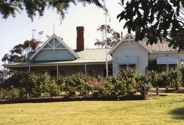
Nyerimilang Homestead is in public ownership, managed by Parks Victoria.Colour photograph of Nyerimilang Homestead showing front view, including rose garden. Situated off Kalimna West Road, Nungurner, it is a large white painted timber homestead, corrugated iron roof of hips and gables, painted green, five internal brick chimneys. Situated above the lake with views of Fraser Island and Flannagan Island, outer barrier and distant ocean. Nungurner Victoriahistoric buildings, local history -
 Sunbury Family History and Heritage Society Inc.
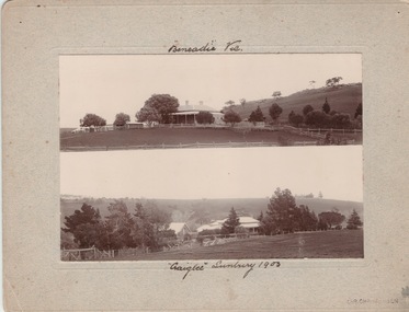
Photograph, Vineyards - Ben Eadie and Craiglee, 1903
The two homesteads are Ben Eadie and Craiglee, which were two of Sunbury's earliest vineyards that were established in Sunbury. James Stewart Johnson designed and built his concrete home, Craiglee, in 1865 where the previous year he had planted out his vineyard on the surrounding 26 acres of land.The property was on the east side of Jacksons Creek on Macedon Road. He concentrated growing Riesling and Hermitage grapes. After his death in 1896, his son Wilfred continued to produce wines until the late 1920s, when he pulled out the vines and concentrated on raising sheep for wool and meat. The Carmody family purchased the property in 1961 and in 1976 decided to replant the vineyard. Ben Eadie was built some time in 1863 and settled by the Eadie family who also were millers. The winery was built into the side of a hill close to the house but the Eadie family tended to concentrate on milling and retailing.In the earliest days of European settlement many wineries were established in the Sunbury area.Two non-digital sepia photographs have been mounted on cardboard. They are photographs of two homesteads with bare hills in the background. They were built in Sunbury in the early days off European settlementBen Eadie Vic. Craiglee Sunbury 1903john eadie, ben eadie winery, james stewart johnson, craiglee, wineries, vineyards -
 Heidelberg Golf Club
Photograph, Bryn Teg 1927, 1927
Photograph of Mrs Thomas' homestead Bryn Teg around the time it ws acquired by the Heidelberg Golf House Company. It is now the entrance to the Heidelberg Golf Club. The building has been altered over the years but retains some original features.Black and white photograph, possibly a copy of the originalheidelberg golf club, bryn teg -
 Working Heritage Crown Land Collection
Domestic object - Key, Former Wollert Church Key
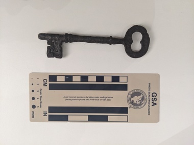
The key was found in the subsurface context adjacent to the original location of the former Wollert Church on the corner of Lehmanns and Epping roads in Wollert in May 2022. The City of Whittlesea gifted the Key to Working Heritage on 2 April 2023.Corroded iron key for church doorfaith, religion, church, wollert church, carome homestead -
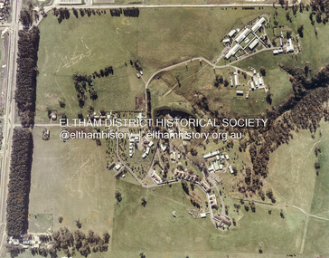
 Eltham District Historical Society Inc
Photograph - Digital Photograph, Alan King, Kangaroo Ground General Store, Eltham-Yarra Glen Road, 28 December 2007
The present store was built circa 1900 to replace another which had been destroyed by fire in 1898, which had replaced a predecessor on the opposite side of the road in 1865. The store was also used as a post office until early 2000s. The general store is historically significant because it has a long association with Kangaroo Ground and has been an important centre of community life for more than 120 years - Council meetings used to be conducted in the front room of the store at a time when Kangaroo Ground rivalled Eltham as the major centre of the Shire. The general store is historically and aesthetically significant as one of a group of three well preserved public buildings in the Kangaroo Ground hamlet and as a major heritage component of Kangaroo Ground which was one of the earliest settled areas of the Shire and which has the character of an English village rather than an Australian settlement. Covered under Heritage Overlay, Nillumbik Planning Scheme. Published: Nillumbik Now and Then / Marguerite Marshall 2008; photographs Alan King with Marguerite Marshall.; p77 Today the general store is an uncommon form of trade but the one at Kangaroo Ground continues a long tradition of friendliness and service. For more than 100 years it has been a centre of community life. In the settlement’s early days a previous general store, on the same site, was the meeting place for the Eltham District Road Board, precursor to the Eltham Shire Council. For years Kangaroo Ground rivalled Eltham as the shire’s major centre. It developed very differently from the rest of the shire as its rich soil attracted prosperous Presbyterian Scots who had large agricultural properties.1 The present store was built to replace another one, which had burnt down in 1898, after replacing a predecessor on the other side of the road in 1865. The store retains its outward character and its cellar, although inside it has changed considerably. It now includes a café and offers local produce, milk bar products, grocery items, gas and other fuel. Until early this century the store was also used as a post office. Kangaroo Ground’s first postmaster was Andrew Ross, who first operated from the school opposite, then from his hotel next to the present tennis court site. The first postmaster at this store was Edward Weller, followed in 1868 by James Anderson. At that time a mail coach ran three times a week between Eltham and Woods Point through Kangaroo Ground, Yarra Flats, Healesville, Fernshaw, Marysville and Matlock. Some early postmasters were Rodger, McLaughlin, Greenway and Burns.2 Burns was the only postmaster operating from the store. The others operated from Andrew Ross’s hotel. The mail service improved in 1892 when coaches ran from Melbourne to Queenstown (now known as St Andrews) and changed horses at Kangaroo Ground twice daily. The only telegraph office in the district at that time was at the Kangaroo Ground Post Office. Telegrams to outlying areas such as Queenstown and Kinglake had to be sent by hand. A local resident in the early 1900s often rode his pony to deliver telegrams and was paid one shilling a mile porterage. The store has also contributed to the lighter side of Kangaroo Ground life. During the years that Con Wraight owned the store, between 1906 and 1946, a new piano was needed for the Kangaroo Ground Hall, so monthly dances were held to raise money. When the piano was bought, a grand ball was held in the Kangaroo Ground Hall to celebrate the occasion and supper followed at Mr Wraight’s barn, cleaned especially for the occasion. Every New Year’s Eve, a Scottish piper would set off from between the store and the schoolhouse, playing his pipes, and march to Cameron’s Pigeon Bank homestead on the Kangaroo Ground-Warrandyte Road. Between 1914 and 1922, the store was a station for the Kangaroo Ground Bush Fire Brigade’s tanker. It consisted of a wooden barrel on a cart, fitted with a hand-pump, and stood on the side of the road outside the store. Joy Ness, who belonged to an early Kangaroo Ground family, moved here in 1940 and recalled her impressions of the store at that time: ‘It was a very dark shop stained in a dark colour and on the walls just below the ceiling hung hurricane lamps, ropes, kitchen utensils and other goods for sale. ‘Goods were weighed on a brass scale with weights, on which mothers also weighed their babies, because the nearest Infant Welfare Centre was at Greensborough. The bacon was cut with a hand slicer and later a pot-bellied stove warmed the store. Farmers and other locals used to gossip around it as they collected their daily mail. In those days the butter and cheese were kept in the cellar as no ice was delivered for cooling.’This collection of almost 130 photos about places and people within the Shire of Nillumbik, an urban and rural municipality in Melbourne's north, contributes to an understanding of the history of the Shire. Published in 2008 immediately prior to the Black Saturday bushfires of February 7, 2009, it documents sites that were impacted, and in some cases destroyed by the fires. It includes photographs taken especially for the publication, creating a unique time capsule representing the Shire in the early 21st century. It remains the most recent comprehenesive publication devoted to the Shire's history connecting local residents to the past. nillumbik now and then (marshall-king) collection, eltham-yarra glen road, kangaroo ground general store -
 Eltham District Historical Society Inc
Photograph - Digital Photograph, Alan King, Edendale Farm Homestead, 29 January 2008
Edendale Farm is Nillumbik Shire Council's environment centre situated in Gastons Road, Eltham between the railway and the Diamond Creek. The homestead on the property was built in 1896 and is of historical significance, being the subject of a Heritage Overlay under the Nillumbik Planning Scheme. The Edendale property was originally part of an extensive land purchase in 1852 from the Crown by pioneer Eltham farmer Henry Stooke. He initially purchased 51 acres and later expanded his holdings by purchasing another three adjacent Crown allotments extending northerly from Josiah Holloway's Little Eltham subdivision. Despite clearing the land, Stooke did not build on this property, choosing to live on his property "Rosehill" at Lower Plenty. In 1896 Thomas Cool, Club Manager of the Victoria Coffee Palace in Melbourne purchased 7 acres of the original Stooke land and built the house now known as Edendale. Cool did not farm the land, instead using it as a gentleman’s residence, retiring to Eltham at weekends. In 1918 he purchased an additional 7 acres but in 1919 he sold the property. Later owners included J.W. Cox, the Gaston family and D. Mummery. In the 1980s the Eltham Shire Council purchased the site for use as a Council depot, but this use did not proceed. Subsequently, it was used as the Council pound. The Edendale Farm Pet Education and Retention Centre was established in the summer of 1988/1989 and was set up to replace the existing dog kennels with a high standard pet retention centre. The design style of the building was established to compliment the features of the existing house. It was equipped with 10 retention pens, a veterinary room and a pet education area where school children and other interested parties learnt about pet care procedures. It was later developed into a community farm and was run by an advisory committee and in 2000 it became an Environment Centre. In early 2006 an advisory committee was established for the development of a master plan for future development at Edendale Farm. The committee included Russell Yeoman, a former long-time shire planner and founding member of the Eltham District Historical Society. At the time of filming the Master Plan and future for Edendale was about continuing to develop Edendale as a centre of environment learning and looking at expanding displays and school program, running a lot more of life-long learning and workshops around sustainable living. Covered under Heritage Overlay, Nillumbik Planning Scheme. Published: Nillumbik Now and Then / Marguerite Marshall 2008; photographs Alan King with Marguerite Marshall.; p101 A sharp turn from busy Wattletree Road by the railway line, brings a surprise. Only 1.4 km from Eltham’s centre, sheep feed, blissfully unaware of the hectic suburban activity so close by. At the entrance to the 5.6ha Edendale Farm is another surprise. A work of art that looks like huge tree trunks transformed into bowler and top-hatted men. The Fences Act 1968 by Tony Trembath with Mark Cain and John Doyle, 1996, is classified by the National Trust of Australia as having Regional Significance. The title refers to a government act on disputes between neighbors over the placement of fences and boundaries. This takes a ‘wry swipe’ at a community divided by trivial squabbles. It also celebrates making do with limited resources.1 Further along on the left, the office wall is decorated with a massive Eltham Copper Butterfly, designed by Robert Tickner and made by school children with used plastic bottles and other waste material. Nillumbik Council runs Edendale as an Environmental Education Centre, to help preserve and enhance the local environment. As early as 1988 the former Eltham Shire Council realised Edendale’s importance in meeting people’s needs, particularly of children, to enjoy farmland. The centre, with the Eltham North Reserve to the north - including remnant bushland and open parkland - makes up the major part of the public open space for this area. The council considers this area will become increasingly important to the local community for recreational use.2 Educational programs aim to encourage community involvement to ensure the long-term rehabilitation and protection of natural bushland areas. Edendale is used by people of all ages - from school children to adults - for environmental programs and workshops, as well as for recreation, to enjoy the domestic animals and to picnic. Edendale is also home to the Environmental Works staff who manage reserves and roadsides and support Nillumbik Friends environmental groups. The Friends propagate plants at the nursery, which grows indigenous plants and sells these to the public.3 The centre demonstrates the sustainable living the farm teaches, with features like solar hot water and drive lighting and for the fireplace, logs of recycled cardboard. Edendale has had a varied history as a dog pound and even as a retreat for Thomas Cool, Club Manager of the Victoria Coffee Palace in Melbourne. His single-storey weatherboard house built in 1896, which still stands, was grander than most homes in Eltham. Although such buildings were common in many other parts of Melbourne, Eltham’s poverty and remoteness did not encourage such construction. The Victorian rectangular-shaped house, with a corrugated iron roof and veranda, has elegant large rooms, leadlight windows, ceiling roses, two bay windows and ornately carved wooden fireplace surrounds. Cool bought seven acres (2.8ha) from pioneer Eltham farmer Henry Stooke’s 200 acre (81ha) farm, which he had bought from the Crown in 1852. In 1918 Cool bought an extra seven acres (2.8ha) but in 1919 sold the estate to farmer John Cox. In 1933 Cox sold Edendale to Mrs Elizabeth Gaston, after whom the road leading to the centre was named. The property was owned by several Gaston family members, who called it Edendale, then by a police constable, Douglas Mummery, until the Shire of Eltham bought it in 1970. Oddly Edendale was known as Mummery’s for almost 20 years, although Mummery owned it only for a short time.4 The shire used Edendale as a dog pound until amalgamation with other municipalities in 1996. The pound then moved to the Yan Yean Road, Plenty site, which had been used by the former Diamond Valley Shire Council. To the west and north the centre is bounded by Diamond Creek and on the east by the Melbourne-Hurstbridge railway line. Part of the Research creek forms the centre’s southern boundary.This collection of almost 130 photos about places and people within the Shire of Nillumbik, an urban and rural municipality in Melbourne's north, contributes to an understanding of the history of the Shire. Published in 2008 immediately prior to the Black Saturday bushfires of February 7, 2009, it documents sites that were impacted, and in some cases destroyed by the fires. It includes photographs taken especially for the publication, creating a unique time capsule representing the Shire in the early 21st century. It remains the most recent comprehenesive publication devoted to the Shire's history connecting local residents to the past. nillumbik now and then (marshall-king) collection, edendale farm -
Glen Eira Historical Society
Document - Christian Family
Six documents on the Christian Family. Nine typed pages by Robert Trumble dated 08/02/1974. Extracts taken from two books written by him about the Christian family in Australia. Three pages about Thomas Christian and Myoora from Caulfield Historical Society Newsletter April/June 1974. Handwritten notes on Thomas and Violet Christian from 1886-1891, possibly taken from Rate Books, unsigned and undated. Handwritten information from the Public Record Office Victoria giving extract of register of Wills, Vol.W1, page 39 Christian, Thomas. Unsigned and undated. Photocopied UK incoming passenger list dated 28/04/1899 showing Mrs. Christian, eight children and maid on the ship Wakool, from Ancestry.com.au Newspaper item dated 26/01/2013 from the Saturday Age mentioning Coolart Homestead, late Victorian mansion, owned at one stage by Tom Luxton who was married to Gertrude Christian.christian thomas, christian violet mary, christian dorothy, christian emily, barclay frank, baker blanch miss, christian florence, trumble hugh, christian arthur james, christian may, player charles dr., llaneast, house names, player janet, player alison, player dorothy, myoora, christian gertrude, christian grace, richards henry caselli, richards harry, trumble robert, trumble kathleen, christian dorothy, dandenong road, caulfield, luxton thomas j., trumble ken, christian edgar john, emery irene, the golden age of cricket, the trumble family in australia, dunstan john r., o’donnell j., caulfield historical society, alma road, hawthorn road, dandenong road, craigellachie, orrong road, p.c. day dawn, p.c. gold mining company ltd., charters towers, mines and mining, gold mining, balconies, verandahs, cast iron work, towers, stained glass, mansions, ievers william, pfeiffer frederick, newmann violet mary, lloyd john charles, architects, brooke family, servants, stairs, teacher work, cellars, flats, slate tiles, roofs, chimneys, fireplaces, land subdivision, coach houses, reed henderson and smart (architects), wills, ships, wakool, henderson anketell -
 Phillip Island and District Historical Society Inc.
Photograph, 1978/79
The Chicory Kiln shown in the photograph is situated on land owned by the McIlwraith family in the 1870s. It is at Heath Hill on the Rhyll-Newhaven Road and is one of the oldest on Phillip Island.Coloured photograph showing a Chicory Kiln on the property which belonged to the McIlwraith family.local history, photographs, buildings - historical, housing, rural industry, coloured photograph, john cook, phillip island, mcilwraith homestead -
 Kiewa Valley Historical Society
Photos - Collection published in 'A History of the Kiewa Valley', By Esther Temple and David Lloyd
Pg. 33 Crawford and Connelly's mail coaches station to change horses and provide 'free bag' mail service x3 weekly to Kiewa, Tangambalanga, Bungoona (Huon). All photos are published in the Kiewa Valley Book "A History of the Kiewa Valley' by Esther Temple and David LloydHistorical photos of the Kiewa ValleyBlack and white photos, varying sizes, published in KVHS history book. In order of appearance: 1. Generic photo of 'Aboriginal Man' Page 9 2. Crawford and Connelly, Royal Mail Coach. pg. 29 3. Early postcard of Kiewa - trees, road, homes pg 76 4. George Le Fevre and School Bus pg 77 5. Kergunyah Creamery pg 80 6. Gundowring Homestead: Built by Charles Barber, pgs 82,83 7. Bogong Hotel 1925 pg 103,104 8. The Junction September 1940 pg 119 9. Mt Beauty pg 119royal mail coach, kiewa, school bus, kergunyah creamery, gundowring homestead, charles barber, bogong hotel 1925, junction camp bogong, mt beauty 1950 -
 Canterbury History Group
Photograph - Monomeath Homestead, c1880
Front of Monomeath with two ladies and a man walking in the garden and another lady sitting on the front verandah.Black and white photocanterbury, monomeath avenue, monomeath, snowden> e.g, canterbury road -
 Bendigo Historical Society Inc.
Document - LONG GULLY HISTORY GROUP COLLECTION: HISTORICAL GUIDE TO BENDIGO
Brochure with an invitation to visit Historical and Mining Museum in Mechanic's Institute, Eaglehawk. Drawing of poppet legs on the front with The Royal Historical Society of Victoria Bendigo Branch. Historical Guide to Bendigo including Self Tours of Bendigo's Famous Goldfields. Forward by John Hattam. Contributors are: H Biggs, Miss L J Parry, A Richardson, L C Bennetts and Edith Checcucci. Credits - The Bendigo Advertiser, Cambridge Press, Mines Department (Bendigo) and J R W Purves. Items include Bendigo Tramways Compiled by H Biggs, Early Bendigo Hotels Compiled by L C Bennetts, Eaglehawk Compiled by H Biggs, Noted Events Compiled by June Parry, The Bendigo Post Office Compiled by LC Bennetts, The Bendigo Goldfield. Introduction to Field and Guide to Some Famous Mines Compiled by A Richardson. Photos include: Pall Mall Bendigo, Ravenswood Homestead, An Early Battery at Kangaroo Flat, Historic High Street Golden Square, The Lonely Grave, Battery Tram c1888, Steam Tram c1892, Electric Tram c1903, The New Chum Railway Golden Square, United Hustlers and Redan Mine Sandhurst Road, Central Deborah Violet Street, Deborah Mine Quarry Hill, Deborah Mine 1000 ft level, First Motion Winding Engine at Central Deborah, Victoria Hill Area, and Looking south from New Chum Hill in 1890's. Also 11010.254, 255, 268, 288a, 288b, and 289.bendigo, history, long gully history group, the long gully history group - historical guide to bendigo, the royal historical society of victoria bendigo branch, historical and mining museum, mechanic's institute eaglehawk, librarian mechanic's institute, miss j parry, john hattam, h biggs, a richardson, l c bennetts, edith checcucci, bendigo advertiser, cambridge press, mines department (bendigo), j r w purves, mr a o'keefe, shire of marong, the sandhurst and eaglehawk tramway company, mr j taylor, mr j hanson, the bendigo tramway company, electric supply company, coliban water suply, juvenile industrial exhibition, geo lansell, cr a harkness, salvation army, vine and fruitgrowers association, decentralisation league, constable thomas ryan, miners association, art gallery, post office, miss broadfoot, bendigo hospital, opera company, bendigo development league, victorian women's franchise league, ana hall, the bendigonian, law courts, temperance hall, trades hall (old wardens court), roman catholic cathedral, shamrock hotel, bendigo philosophical society, old bendigonian society, bendigo fire brigade, bendigo volunteers to south african war, hawkins, porcupine inn, criterion hotel, royal hotel, bendigo hotel, black swan hotel, gillies bakery, hibernian hotel, sandhurst hotel, freemasons hotel, courthouse hotel, shamrock hotel, governor hotham, heffernan & crowley, new chum railway, victoria quartz, shenandoah, shamrock mine, hercules no 1 (originally pearl east), hercules new chum (late pearl), carlisle mine, mr arblaster, meurer, sandhurst bee, benevolent asylum, bendigo gas company, a lloyd, coliban water supply scheme, cr w v simons, eaglehawk council, j mouat, sir henry barkly, agricultural and horticultural exhibition, sandhurst and eaglehawk boroughs, cr john mcintyre, latham and watson's mine, galatea (model ship), st paul's church of england, rev g p despard, fine arts exhibition and exposition, bendigo rifle association, strathfieldsaye shire hall, corporate high school, bendigonian society, richard andrews, easter fair, g aspinall, j burnsides, sir h manners sutton, beehive stores, mining exchanges, bendigo water works, city family hotel, bendigo united friendly society medical institute and dispensary, benevolent asylum, jewish synagogue, masonic hall, school of mines, mr j h abbott, australian natives association, royal princess theatre, albion hall, central state school, high school, gravel hill state school, electricity commission, james mouat, warring natives, the rocks, joseph crook, gold discovery, marong district roads board, camp hotel, mr charles sherratt, city of bendigo, mt alexander north run, grice and heape, ravenswood, gibson and fenton, mrs john kennedy, mrs patrick farrel, mr j a paton, mr lachlan mclachlan, theatre royal, sir charles and lady hotham, harney's bridge, e j ennor, sandhurst fire brigade, the health of towns act, mr townsend, cornish & co, bendigo pottery, bendigo agricultural society, pike or pyke, baby health centre, sandhurst post office, government survey office, sandhurst trustees company, mr h b briston, savings bank, telegraph office, sir henry brougham lock, hon sir john nimmo, sandhurst public offices, the new prince of wales mine, new prince of wales no 2, the whip and jersey, lansell's big 180, new chum and victoria mine and battery, new chum railway, koch's pioneer, south new moon, catherine reef united, new moon, virginia mine, south belle vue, new chum railway, central nell gwynne, north nell gwynne, ironbark mine, new chum syncline, hercules, herculesl energetic, roberts & sons, harkness & co, horwoods, great southern, ulster, carlisle, cornish, new st mungo, duchess tribute, south devonshire, hopewell mine, saxby mine, mcnair & co, mr king, bourke and wills, sandhurst hotel, the dascombe nugget, victoria nugget, r r haverfield, ballerstedt, rae, wittscheibe, lazarus, cave and amos, bendigo amalgamated goldfields, bendigo mines limited, the deborah, north deborah, central deborah, the new red white and blue consolidated (big blue), union, lansell's new red white and blue 9later no 3 shaft), h harkness & co, thompson & co, central deborah, lansell's bendigo battery, north red white and blue, central red white and blue, roberts and sons, little 180 (originally lansell's 180 no 2 shaft), john brown knitwear factory, south ironbark originally victoria consols east shaft, ironbark (originally ironbark east shaft), manchester arms hotel, wattle gully mine chewton, hercules, old wheal-owl, central nell gwynne, gold mines hotel, bendigo city council, jack barker, the new chum syncline, the courier of the mines, telegraph office, bendigo cemetery, white hills cemetery, eaglehawk cemetery, kangaroo flat cemetery, new moon, suffolk united, north new moon, fortuna hustlers, buckell & jeffrey's, royal hustlers reserve no 2 (city and park shafts), jonathan harris, latham and watson, great hustlers, great extended hustlers, j hustler, latham, watson, tribute or pups shaft, bendigo's worst mining disaster, hustlers reef (old hustlers), hustlers reef no 1, lansell's comet, the old comet (cooper's claim), united hustlers and redan, comet hill state school, k k shaft, north or new hustlers (agnew hustler), johnson's no 3, south johnson's, lansell's sandhurst needle, cleopatra needle top, british american, collman and tacchi, south virginia, saddle reefs and spurs, pall mall bendigo, ravenswood homestead, an early battery at kangaroo flat, historic high street golden square, the lonely grave, battery tram c1888, steam tram c1892, electric tram c1903, teh new chum railway golden square, united hustlers and redan mine sandhurst road, central deborah violet street, deborah mine quarry hill, deborah mine 1000 ft level, first motion winding engine at central deborah, victoria hill area, looking south from new chum hill in 1890's -
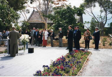 Sunbury Family History and Heritage Society Inc.
Photograph, Veronica Burgess, Rose Garden opening, 12 December 1999
The Mayor of Hume City Council, Jack Ogilvie, was addressing local 12th December 1999 in the grounds of the former Bulla Roads Board building. St. Mary's Church of England is adjacent to the Rose Garden. Alister Clark, a former Bulla resident and a rosarian, developed many different species of roses at his Glenara property. The garden in Bulla has been erected in his memory.Alister Clark developed many rose varieties that could withstand Australia's climate. Many of them, such as the Lorraine Lee, have become a popular addition in gardensA non-digital coloured photograph of a man standing in front of a lectern addressing a group of people who are standing in a garden. A small bluestone church is on the adjacent property.alister clark, 'glenara' homestead, bulla, alister clark memorial rose garden, roses, jack ogilvie -
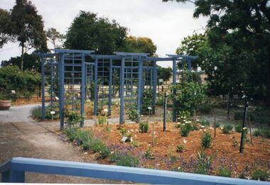 Sunbury Family History and Heritage Society Inc.
Photograph, Veronica Burgess, Alister Clark Rose Garden, 12th December 1999
The garden in the photograph is a section of the newly designed and planted Alister Clark Memorial Rose Garden situated in the grounds of the former Bulla Roads Board property. The garden was officially opened on 12th December 1999 in the grounds of the former Shire of Bulla Office building.The garden honours the work of Alister Clarke, who developed many different of rose varieties suited to Australia's climate at his 'Glenara' property in Bulla.A non-digital coloured photograph of a newly landscaped garden with a series of trellises in the garden bed and young rose bushes. Some mature trees are growing in the background.rose gardens, roses, alister clark memorial rose garden, glenara homestead, bulla -
 Stawell Historical Society Inc
Photograph, Four Posts Inn in Glenorchy -- Building no longer exists
Four Posts Inn. Glenorchy built about 1841 by John Gleeson on the Wimmera River at Glenorchy. Building no longer exists as burnt down in 1944. Located on the site now known as Glenorchy (Victoria). Glenorchy is approximately 20Km from the former Ashen's pastoral run occupied by Dugald McPherson. The Four post Inn was a "Staging Camp" for the police escort route during the transportation of gold by road from Mount Alexander gold fields (Bendigo) to Adelaide South Australia in 1852-53. The police escort is known to have called in at Ashens homestead to visit Dugald McPherson. The Four Post Inn was the scene on the occasion of and encounter between the police escort and bushrangers. At a later date The Four Post Inn was a staging camp for the horse drawn coach service between Stawell and Horsham.Small weatherboard building with no verandah and tree blocking the view. Cat in front of doorway.stawell -
 Linton and District Historical Society Inc
Photograph, 'Glenfine' Shearing Shed, 1890
In July 1840, Glenfine, consisting of 31,440 acres, was acquired by Thomas Downie. In March 1842 the 'Right of Run' was taken up by Thomas Chirnside who with an imported stallion 'Delapre' ran a horse stud. He apparently lived here for ten years and employed a gardener with a wife and five children from Hobart, Tasmania. Only some blocks of stone and a few trees remain of their homestead. In 1853 the property was transferred to Dr. John Chirnside, an elder brother of Thomas Chirnside. In 1857, William Rowe of Naringal purchased Glenfiine where he and his family lived until 1904 when it was bought by Richard Howell's estate. It was then 39,000 acres. The present house was built by the Rowes in 1872 of bluestone quarried on the property with a cement render overall. The architect was H.R. Casselli. Gold was found on the property and by 1898 the township of Hollybush was first reported, situated at either side of the front entrance, on the Cressy Road. The land for the township was given by William Rowe. In 1911 R.C. Howell, son of Richard Howell, became the owner, followed by his son in 1960. By 1990 Hollybush had a population of 426 persons. All of the early history of Glenfine, documents etc., were destroyed when Naringal homestead was burnt down in 1944. Glenfine was classified by the National Trust in 1974 and is on the Heritage Commission Register. Mounted black and white image of a large group of men and boys in front of a weatherboard shearing shed. The men are each holding a pair of hand shears. One young man is kneeling on top of a wool bale. A small blue biro 'x' identifies W. Todd. Glenfine was a pastoral station, and the original homestead still stands.shearing sheds, shearers, rural activity, william todd, glenfine pastoral station, thomas chirnside, thomas downie, richard howell, william thomas rowe -
 Eltham District Historical Society Inc
Photograph - Colour Print, Janefield, Bundoora, c.1982
The photo encompasses what is present-day University Hill shopping complex and the Janefield Wetlands. Plenty Road is just visible to the left of the photo. Janefield was an area 18 km north-east of central Melbourne that is now part of Bundoora. In 1842 a flour mill, powered by the Plenty River, was built at Janefield, although the locality was not known by that name at that time. It seems that the name Springfield was used in the late 1840s, after a Springfield homestead, and this was changed to Janefield possibly upon the death of Jane Brock in 1847. She was the wife of James Brock, a local landowner and son of the purchaser of the flour mill. This photo is not strictly within the area of interest for EDHS but overlaps do occur at times with other Society’s interests through families and other associated connections. Eltham District Historical Society member (and Greensborough Historical Society member), Peter Van Eeken was undertaking research into this photo and approached the Local History Librarian at Yarra Plenty Regional Library to enquire about digitising the large print copy to facilitate research. Approaches were made to EDHS who had suitable facilities and were willing to accommodate and all parties agreed to add the image as part of their respective collections in partnership. Michael Lanigan, started work as a message boy at Mont Park when he left school at age 14. He worked his way up the system to become farm manager at Mont Park and Janefield Special School. He was one of the last people to drive a herd of cattle (in 1964) between the two locations along Plenty Road. He retired when the school closed around 1993. Mick pointed out the location of three remnant farm houses of the 1800s. The Brock House being the main one. Peter has been unable to find any photos of the Brock House, which what built in the late 1850s, severely burnt in the 1930s and demolished in the mid 1960s. The tree plantation along Plenty Road was established in 1930 and cut down in the mid 1980s. The Victorian Government established tree plantations at about 350 schools in the early 1930s. Briar Hill School had one but Peter is not sure about any other local schools having a tree plantation. Mick informed Peter that it was his job to remove the 14 acres of pine tree roots, after the trees were cut down (due to old age and an infestation of sap sucking insects). For Mick, this was an impossible job, so he arranged a contract, to house all the soil removed from works associated with the construction of the Greensborough Bypass, which needed temporary storage as it was too valuable, and would be great for use in road construction. The contract to store the soil was important to Mick, as the contract stipulated that when the soil was eventually removed, the tree roots had to be removed too. Which got rid of Mick's headache. Apparently, the huge mound of soil that covered the roots in the late 1980s could be seen from Briar Hill. Based on this, the photo is most likely to have been taken 1982 or 1983. The key to a final date is working out when the Board of Works Office opened but so far no information has come to light. (It was purchased by La Trobe University in 1991). The Office existed, or is hinted at, in the photo at the extreme north of the photo, opposite McKimmies Road, on the eastern side of Plenty Road. Photo on loan from Michael Lanigan via Peter Van Eeken. He cannot recall why it was taken. brock family, janefield, janefield drive, janefield wetlands, plenty road, university hill -
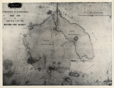 Federation University Historical Collection
Document - Documents, History of the Coghill Family
History of the Coghill Family from the 1700s.Typed and handwritten papers relating to the Coghill Family. Part ot the handwritten history "The Coghill Family - 13-9-40 Statement by Mr Henry Holmes of Essendon" includes the following: (Page 1) "The original Captain Coghill owned Glendaruel and Glendonald Stations (the homestead of the latter was Andrew Munro's original home.) He had five sons and two daughters ... William Coghill Jnr, a son of Captain Coghill married Miss Catherine Dorothy Holmes. They had no family and they adopted William and Henry Holmes, their nephews, who were the sons of Edward Carter Holmes, brother of Mrs William Coghill Jnr. (Page 2 - does not run on from page1) "The family, and descendants of Edward Carter Holmes, via the William Holmes lineage, lived at "Sauchiburn" Ascot, Vic. The property, fronting what was to become known as Lesters Road, was sold by the family in the 1980's. The namesake of Lesters Road, Mrs Helen Lester (nee Coghill), had also descended from the original Coghill settlers. During my 1960 - 1970 childhood in the area, the Lesters lived opposite "Sauchieburn" on a property called "Burnside". In 1950 a stone cairn commemorating the original Coghill settlers had been sited on the roadside common between both properties by descendants of the Coghill Holmes family. https://victoriancollections.net.au/items/5b0e196821ea69108c477463. The Lester property was subsequently purchased by another Edward Carter Holmes descendant, Graeme Spittle from "Mount Cavern" Ascot, and David Glenn and Chris Canning https://lambley.com.au/visit/ I believe descendants via my mother's, Elizabeth Chatham (nee Holmes), lineage continue to farm and /or reside in the adjacent Ascot vicinity on the "Launchley", "Gleno" and "Hazeldean" properties. Interestingly, "Hazeldean" had been originally owned by Robert Reid and his wife Adelaide Helen Reid (nee Holmes). Adelaide and Catherine Coghill (nee Holmes) were sisters." [Memory of Jane Dyer (nee Chatham) 2025] coghill, pioneer family, land settlement in victoria, new south wales, captain john coghill, donald john coghill, will of william coghill senior, indenture agreement, david coghill, william baldwin, talbot, elizabeth coghill, margaret coghill, christina coghill, george coghill, helen coghill, john coghill, catherine dorothy holmes