Historical information
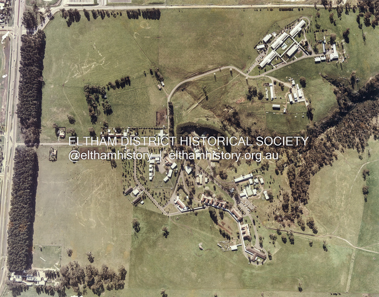
The photo encompasses what is present-day University Hill shopping complex and the Janefield Wetlands. Plenty Road is just visible to the left of the photo.
Janefield was an area 18 km north-east of central Melbourne that is now part of Bundoora.
In 1842 a flour mill, powered by the Plenty River, was built at Janefield, although the locality was not known by that name at that time. It seems that the name Springfield was used in the late 1840s, after a Springfield homestead, and this was changed to Janefield possibly upon the death of Jane Brock in 1847. She was the wife of James Brock, a local landowner and son of the purchaser of the flour mill.
This photo is not strictly within the area of interest for EDHS but overlaps do occur at times with other Society’s interests through families and other associated connections.
Eltham District Historical Society member (and Greensborough Historical Society member), Peter Van Eeken was undertaking research into this photo and approached the Local History Librarian at Yarra Plenty Regional Library to enquire about digitising the large print copy to facilitate research. Approaches were made to EDHS who had suitable facilities and were willing to accommodate and all parties agreed to add the image as part of their respective collections in partnership.
Michael Lanigan, started work as a message boy at Mont Park when he left school at age 14. He worked his way up the system to become farm manager at Mont Park and Janefield Special School. He was one of the last people to drive a herd of cattle (in 1964) between the two locations along Plenty Road. He retired when the school closed around 1993. Mick pointed out the location of three remnant farm houses of the 1800s. The Brock House being the main one.
Peter has been unable to find any photos of the Brock House, which what built in the late 1850s, severely burnt in the 1930s and demolished in the mid 1960s.
The tree plantation along Plenty Road was established in 1930 and cut down in the mid 1980s. The Victorian Government established tree plantations at about 350 schools in the early 1930s. Briar Hill School had one but Peter is not sure about any other local schools having a tree plantation.
Mick informed Peter that it was his job to remove the 14 acres of pine tree roots, after the trees were cut down (due to old age and an infestation of sap sucking insects). For Mick, this was an impossible job, so he arranged a contract, to house all the soil removed from works associated with the construction of the Greensborough Bypass, which needed temporary storage as it was too valuable, and would be great for use in road construction.
The contract to store the soil was important to Mick, as the contract stipulated that when the soil was eventually removed, the tree roots had to be removed too. Which got rid of Mick's headache. Apparently, the huge mound of soil that covered the roots in the late 1980s could be seen from Briar Hill.
Based on this, the photo is most likely to have been taken 1982 or 1983. The key to a final date is working out when the Board of Works Office opened but so far no information has come to light. (It was purchased by La Trobe University in 1991). The Office existed, or is hinted at, in the photo at the extreme north of the photo, opposite McKimmies Road, on the eastern side of Plenty Road.
Photo on loan from Michael Lanigan via Peter Van Eeken. He cannot recall why it was taken.
Physical description
Digital scan of hard copy print on cardboard approx 60 cm sq