Showing 2735 items
matching otway-reef
-
 Robin Boyd Foundation
Slide, Robin Boyd, 1966
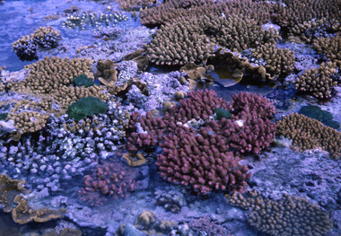
Robin Boyd was appointed Exhibits Architect for the Australian Pavilion at Expo ‘67 in Montreal. In 1966 Boyd travelled to Far North Queensland and the Northern Territory for research – the Expo exhibits included a coral display and native plant garden.Colour slide in a mount. Great Barrier Reef, Queensland, AustraliaMade in Australia / 4 / MAR 66M1queensland, slide -
 Robin Boyd Foundation
Slide, Robin Boyd, 1966
Robin Boyd was appointed Exhibits Architect for the Australian Pavilion at Expo ‘67 in Montreal. In 1966 Boyd travelled to Far North Queensland and the Northern Territory for research – the Expo exhibits included a coral display and native plant garden.Colour slide in a mount. Great Barrier Reef, Queensland, AustraliaMade in Australia / 6 / MAR 66M1queensland, slide -
 Stawell Historical Society Inc
Photograph, Stawell Gold Mine
looking across mine toward Reefs Road big Hillgold mining -
 Queenscliffe Maritime Museum
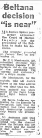
Newspaper - Various newspaper clipping re Beltana wreck, Locals & other news articles, c1963
shipwreckscoastal shipwrecksnews clipping re the BELTANA aground on Corsair Reef, 1963Reverse " NIL ".historical references -
 Stawell Historical Society Inc
Map, Plan Shewing Auriferous Deposits and Reefs (Map of Water Races), c1878
Plan Shewing Auriferous Deposits and Reefs (Map of Water Races)stawell, water -
 Bendigo Historical Society Inc.
Archive - HUSTLERS REEF RESERVE, December 2011
DVD. Hustlers Reef Reserve, CMP Final Draft.December 2011. -
 Bendigo Historical Society Inc.
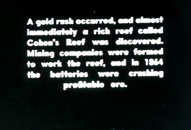
Slide - DIGGERS & MINING. DIGGERS AND MINERS, c1864
Diggers & Mining. Diggers and miners. Walhalla - Gold Town. A gold rush occurred, and almost immediately a rich reef called Cohen's Reef was discovered. Mining companies were formed to work the reef, and in 1864 the batteries were crushing profitable ore. Markings: 12 995 WAL. Used as a teaching aid.hanimounteducation, tertiary, goldfields -
 Otway Districts Historical Society
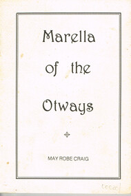
Book, Marella of the Otways, 1985
Marella of the Otways: bush stories and verse. May Robe Craig. E.Ross Gordon (illus.) 1st ed. No location; May Robe Craig; 1985.84 p.; illus. Soft cover.marella; otways; bush stories; bush verse; melligig waters; tomahawk creek; heytesbury; -
 Australian National Surfing Museum
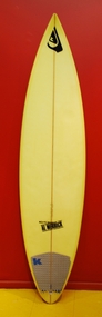
Surfboard, 1/1/1996 (estimated)
Kelly Slater is contemporary surfing's dominant competitive presence and a truly inspirational surfer. By the end of 2009 Kelly had won a record 9 professional World Surfing Championships. This surfboard is one of Kelly's from 1996 shaped by world renowmed shaper Al Merick from Channel Island Surfboards, Santa Barbara, California. This board was ridden by Kelly in Indonesia in 1996 and featured on the cover of Surfer Magazine in November 1996 in a sequence shot at speed reef Grajagan.This surfboard was ridden by Kelly Slater throughout 1996 and most famously featured on the cover of Surfer Magazine. In 1996 Kelly Slater was at the peak of his surfing powers. During this year he won his 4th World Professional Surfing championship equalling the record held by Australian Mark Richards. This surfboard has international significance and represents a number of innovative design trends during this period.Kelly Slater surfboard shaped by Al Merrick (Channel Island Surfboards)in 1996. The surfboard is a three fin, 6' 6" rounded pin, colour yellow. The board, with Kelly riding it, featured on the cover of Surfer magazine in November 1996 in a sequence, shot in Indonesia at speed reef Grajagan.Deck - Quiksilver, Al Merrick logo Bottom - 'Glasscraft by Bob Haakenson Santa Barbara' behind last fin. Al Merrick logo 63921A Kelly on stringerkelly slater, al merrick, surfer magazine, grajagan, channel island surfboards, quiksilver -
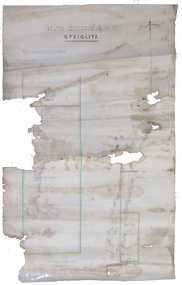 Federation University Historical Collection
Plan, South Dividend Quartz Mining Company Plan
A hand drawn and coloured plan showing the position of the following gold mines in Steiglitz - South Dividend Company, the Marquis of Lorne Company, New Year's Reef, Malekoff Company and the Brazilian Reef.steiglitz, south dividend company, marquis of lorne company, new year's reef, malekoff company, brazilian reef, t. woolgrove -
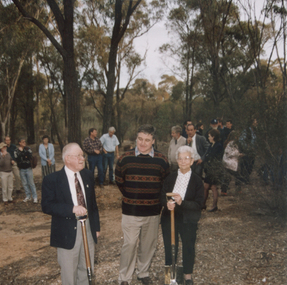 Tarnagulla History Archive
Photograph: Havelock Reef Ceremony, 28th April, 1995
Donald Clark Collection. A colour photograph depicting Don Clark, Dick Sandner and Lorna Goltz at a ceremony to open drive to tunnel under the hill, Havelock Reef, South Poverty Reef, Tarnagulla. Original photograph. -
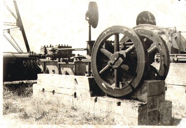 Bendigo Historical Society Inc.
Photograph - NELL GWYNE MINING, c1900s approximate
Nell Gwynne Reefs Air compressor. Unmounted, Black and white Print. Physical condition: Loose photograph. Inscriptions on back: Hand written on back 'Nell Gwyne Reefs / Air Compressor'organization, business, nell gwynne reefs mine -
 Bendigo Historical Society Inc.
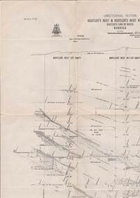
Map - HUSTLER'S REEF & HUSTLER'S REEF NO 1 MINES - PLAN OF THE HUSTLER'S REEF & HUSTLER'S REEF NO 1 MINES
Plan of the Hustler's Reef & Hustler's Reef No 1 Mines on the Hustler's Line of Reefs Bulletin No 33, Plate No XVII. Two drawings with different levels on each for clarity. Shows depth and some geographical features. Geological Survey of Victoria emblem. Signed by H A Whitelaw Underground Survey Office Bendigo, September 1913. mining, parish map, hustler's reef & hustler's reef no 1 mines, hustler's line of reefs, geological survey of victoria, underground survey office bendigo, h a whitelaw -
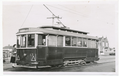 Ballarat Tramway Museum
Photograph - Black & White Photograph/s, Digital Image, Wal Jack, 27/06/1957 12:00:00 AM
Yields information about Ballarat Trams and streetscapes early 1960's and the details of the Victoria St terminus, Yields information about Ballarat Trams and streetscapes early 1960's and the details of the Victoria St terminusBlack and white print of Ballarat 17, in Victoria Street, at Otway St photographed by Wal Jack, 27/6/1957. Two copies. A lady is standing at the back of the tram, possibly talking to the conductor. Tram has the destination of Gardens via Sturt St West. Has the Convent building in background. Photo print courtesy of Port Dock Railway Museum, now the National Railway Museum. See worksheet 4311 for letter and details of prints sent to Bill Scott, 19/10/2001. Any photo credit to mention NRM Collection. 4412.1 - Digital image from the Wal Jack Ballarat Album of the same photograph. See i3 for details of the rear of the photograph.On rear of copy 1 "SEC Ballarat / 17 / Victoria / 27/6/57 / Wal Jack" Copy 2 "DAC" in ink, bottom right hand corner. 4412.1 - on rear of photo in ink, "SEC Ballarat, No. 17 Victoria St at Otway St, Ballarat East 25 June '57" and "W. Jack photo Neg. to D. Colquhoun"trams, tramways, victoria st, tram 17 -
 Bendigo Historical Society Inc.
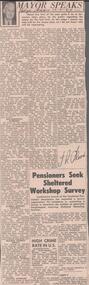
Newspaper - ALBERT RICHARDSON COLLECTION: THE MAYOR SPEAKS: MINE SITES
Newspaper article 'The Mayor Speaks' dated 12th August 1967, Bendigo Advertiser. Article by J.R. Flood. Mayor of Bendigo, detailing the location of mines including the Duchess of Edinburgh on the New Chum line, the mines on the Christmas line of reef, the Deborah reef mines, and the Sheepshead reef. Mine reclamation schemes are also addressed in the articlebendigo, mining, reef lines and mines -
 Bendigo Historical Society Inc.
Map - HUSTLER'S LINE OF REEFS, September 1913
Map, Hustler's Line of Reefs, Hustler's Reef & Hustler's Reef No. ! Mines, Bendigo, Longitudinal Section,Plate No.XX (20). NOTE-- Plates 4,8,13,20,26 & 31 form a Logitudinal Section from Fortuna Hustler's to Hustler's Consols Mine.Bulletin No 33 Signed H.A.Whitelaw. Drawing shows the vertical shaft descending to over 1601 feetUnderground Survey Office, Bendigo,map, bendigo, hustler's reef & hustler's reef 1 -
 Otway Districts Historical Society
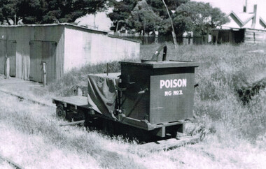
Photograph, R. Preston, Beech Forest: poison trolley, 1958, 8 January 1958
B/W. Poison trolley NG No.1 on the Gang Shed siding at Beech Forest on 8 January 1958. The Gang Shed is shown. In the right background the Otway Shire Secretary's house.beech forest; railways; -
 Stawell Historical Society Inc
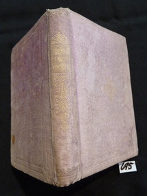
Book, Society for Promoting Christian Knowledge, Arthur or The Chorister's Rest, 1870
Master R H Dane Church of England Sunday School Reefs Jan 17th 1870stawell religion -
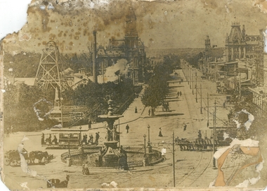 Bendigo Historical Society Inc.
Photograph - PURDY COLLECTION: PALL MALL PHOTO
Sepia image of Pall mall, taken from just south of the Alexandra Fountain. Shows horse drawn vehicles, people walking. Women dressed in long dresses, tramline on road, tram heading up towards View Street. Poppet head and mining chimney of Royal Reserve mine on LH side of Pall Mall. Post Office and Shamrock buildings on either side in mid-ground. On back of image in biro 'Royal Reserve G.M., Hustlers line of reef, Pall Mall, Bendigo.'bendigo, streetscape, pall mall -
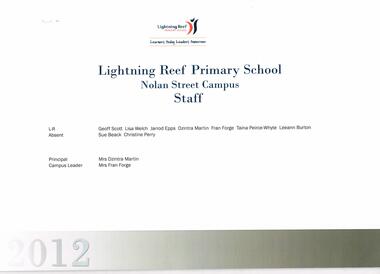 Bendigo Historical Society Inc.
Document - BENDIGO NORTH P.S. COLLECTION: STAFF LIST 2012
Lightning Reef Primary School Staff, Nolan Street Campus. 2012education, primary, lightning reef primary school -
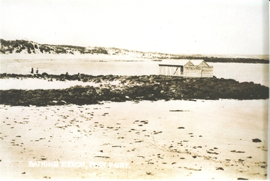 Port Fairy Historical Society Museum and Archives
Photograph, Bathing Beach Port Fairy
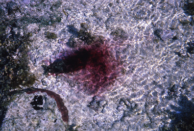
Photograph of v shaped stone reef with bathing boxes perched on topBathing Beach Port Fairybathing box, south beach, ocean, sea, rock, reef -
Tarnagulla History Archive
Research file: New Chum Claim, Poverty Reef, August 1995
David Gordon Collection. Research file: New Chum Claim, Poverty Reef by Eric WIlkinson.mining -
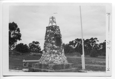 Tarnagulla History Archive
Photograph depicting the Poverty Reef Mine Monument, Tarnagulla, c. 1960s
Murray Comrie Collection. This is an original photograph. Sepia photo-postcard depicting the Poverty Reef Mine Monument, TarnagullaMarked in pen to indicate height of monument.tarnagulla, poverty mine, monuments, king street -
 Tarnagulla History Archive
Photograph depicting the Poverty Reef Mine Monument, Tarnagulla, c. 1960s
Murray Comrie Collection. This is an original photograph. Sepia photo-postcard depicting the Poverty Reef Mine Monument, Tarnagullatarnagulla, poverty mine, monuments, king street -
 Bendigo Historical Society Inc.
Document - LUCY HILL COLLECTION: BENDIGO MINING FIELD, 1860-1951 approx
Articles by Lucy Hill: Articles about the reefs and whims around Bendigodocument, gold, mining in bendigo, lucy hill collection - from the manuscript of the late lucy hill and published in the bendigo advertiser - compiled by john hattam -
Bendigo Historical Society Inc.
Archive - MCCOLL, RANKIN AND STANISTREET COLLECTION: NAPOLEON REEF MINING BOX
Mining Box: metal box, painted dark blue, formerly box number 489 - Now Napoleon Reef Mining Box 5. Tag affixed to front ' box 489' Printed on door in white paint ' Napoleon Reef'. Box contains various documents relating to Napoleon Reef Mine. Documents are individually catalogued within box.mining, parish map, mccoll, rankin & stanistreet, mccoll rankin & stanistreet, mining, gold mining, napoleon reef -
 Bendigo Historical Society Inc.
Document - VICTORIA QUARTZ - NOTES ON THE VICTORIA QUARTZ MINE
Handwritten notes on the Victoria Quartz Mine. Notes mention length of claim along the reef, amalgamation of claims, depths the gold was found, value of gold, dividends paid and calls, where the gold was found on the reef and the type of stone encountered. Also mentions the returns of the reef for the years 1896 to 1898, not including pyrites And amount of gold from loads.document, gold, victoria quartz, victoria quartz, notes on the victoria quartz mine, mr william rae, mr lansell, 180 mine, victoria reef, great central victoria, new chum united, j h craig, a m s special edition -
Bendigo Historical Society Inc.
Document - Digital, KEN BICE COLLECTION: STOPES ON CATHERINE REEF
Copy of photo: written on back stopes on the Catherine Reef, spurs, Catherine Reef United Mine, Eaglehawk, 1905. Image shows four men underground with picks, working in a stope. This is a digital only photograph.bendigo, mining, catherine reef, catherine reef, bendigo, stopes, miners, mining -
 Bendigo Historical Society Inc.
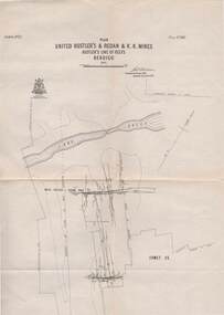
Map - STRUGNELL COLLECTION: UNITED HUSTLER'S & REDAN & K.K.MINES, September 1913
Map, Hustler's Line of Reefs, Bendigo, United Hustler's & Redan, & K.K.Mines, Plate No.XXV11 (27), Long Gully, Lightning Hill Line of Reefs at surface.Dated September 1913 //Bulletin 33.Signed H.A.Whitelaw.Underground Survey Office,Bendigo,map, bendigo, united hustler's, redan, k.k.mines -
 Bendigo Historical Society Inc.
Document - ALBERT RICHARDSON COLLECTION: VICTORIA REEF, TRY ME WELL REEF AND HERCULES REEF
Three page handwritten document transcribed by Albert Richardson. On top of document: The Victoria Reef, Victoria Spurs, East Victoria Reef, Try McWell Reef and the Hercules Reef. Reference Dickers Mining Record, Vol 1, No. 1 Page g. November 23, 1861. Document details the location of the reef lines and some of the mines and claims along them. For example, page one: 'The main Victoria, really a continuation of the South Victoria, commences at a point to the west of the Mt Korong Road, where the high portion of the ranges is intersected by the head of the Iron Bark Gully, the southern most claim being Ballerstedt and Son's. This line of reef is remarkable from the extraordinary richness of the lodes, not less than from the singular manner in which the gold has been distributed'.Albert Richardsonbendigo, mining, victoria reef line