Showing 432 items matching "quarry road"
-
 Glenelg Shire Council Cultural Collection
Photograph - Photograph - Cape Grant Quarry, Portland, n.d
Port of Portland Authority Archivesport of portland archives, aerial photography, portland harbour, cape grant quarry -
Glenelg Shire Council Cultural Collection
Photograph - Photograph - Cape Grant Quarry, Portland, n.d
Port of Portland Authority Archivesport of portland archives, cape grant quarry, machinery, bulldozer, harbour development -
Glenelg Shire Council Cultural Collection
Photograph - Photograph - Cape Grant Quarry, Portland, n.d
Port of Portland Authority ArchivesFront: Back- '40 cms wide'- pencilport of portland archives, cape grant quarry, portland harbour, harbour development -
Glenelg Shire Council Cultural Collection
Photograph - Photograph - Cape GRant Quarry, Portland, n.d
Port of Portland Authority Archivesport of portland archives, cape grant quarry, harbour development -
Glenelg Shire Council Cultural Collection
Photograph - Photograph - Cape Grant Quarry, Portland, n.d
Port of Portland Authority Archivesport of portland archives, cape grant quarry, portland harbour, harbour development -
Glenelg Shire Council Cultural Collection
Photograph - Photograph - Cape Grant Quarry, Portland, n.d
Port of Portland Authority Archivesport of portland archives, aerial photography, portland harbour, cape grant quarry -
Glenelg Shire Council Cultural Collection
Photograph - Photograph - Cape Grant Quarry, Portland, 03/08/1953
Port of Portland Authority Archives. From the Port of Portland website: Just 6km south of Portland, the Cape Grant Quarry is located on the eastern cliff of Cape Sir William Grant. This cape represents the core of a volcanic complex between two collapse calderas which underlie Nelson and Grant Bays to the west and east respectively. The Cape Grant quarry supplied an inexhaustible quantity of bluestone for the building of the new Portland harbour. The first stone was tipped at the root of the main breakwater on 17 November 1952. A small band of interested citizens were there to see the historic event. In the building, the breakwater was consolidated by the heavy traffic of Euclid’s and bulldozers and was further solidified by several storms that swept over it. Nowadays, blasting at the quarry is heavily regulated and carried out under the instructions of a qualified “powder monkey.” The days of seeing large explosions, along with the deep long loud BOOM are long gone with techniques of controlled blasting now improving overall environmental and safety standards.Front: Back- Purple PHT Stampport of portland archives, cape grant quarry, harbour development, construction -
Glenelg Shire Council Cultural Collection
Photograph - Photograph - Blacknose Quarry Portland, 21/10/1952
Port of Portland Authority ArchivesFront: Front- Blacknose Quarry face 21/10/52 looking south showing rock brought down by trial blast'- Printed in bottom frame Back- Purple PHT Stamp 5/3- Ink, top leftport of portland -
Glenelg Shire Council Cultural Collection
Photograph - Photograph - Cape Grant Quarry, Quarry, Cape Grant, 01/11/1956
Port of Portland Authority ArchivesFront: Back- Border ruled around in pencil. Cape Grant Quarry 1/11/56 'View to south east showing excavtor on limestone level, quarry master on 70ft level and box blast result on 40ft level in foreground. Note rock fave obscured by over burden material' - Pencil '5 x 3/4 approx' - pencilport of portland archives -
Glenelg Shire Council Cultural Collection
Photograph - Photograph - Cape Grant Quarry, n.d
Port of Portland Authority Archivesport of portland archives, cape grant quarry -
Glenelg Shire Council Cultural Collection
Photograph - Photograph - Cape Grant Quarry, n.d
Port of Portland Authority Archivesport of portland archives, cape grant, euclid -
Glenelg Shire Council Cultural Collection
Photograph - Photograph - Quarry, Cape Grant, n.d
Port of Portland Authority Archivesport of portland archives -
Glenelg Shire Council Cultural Collection
Photograph - Photograph - Cape Grant Quarry, n.d
Port of Portland Authority Archivesport of portland archives, cape grant quarry -
Glenelg Shire Council Cultural Collection
Photograph - Photograph - Cape Grant Quarry, n.d
Port of Portland Authority Archivesport of portland archives, cape grant quarry -
Glenelg Shire Council Cultural Collection
Photograph - Photograph - Quarry, Cape Grant, n.d
Port of Portland Authority Archivesport of portland archives -
Glenelg Shire Council Cultural Collection
Photograph - Photograph - Quarry, Cape Grant, n.d
Port of Portland Authority Archivesport of portland archives, cape grant quarry -
 City of Moorabbin Historical Society (Operating the Box Cottage Museum)
Photograph - Map of Dendy's Special Survey, 1852 Map of Henry Dendy's Special Survey of 1841, 19th Century
A Map drawn in 1852 that shows the 5,120 acres that formed Dendy's Special Survey of 1841. In 1840 Henry Dendy, a farmer in Surrey, England acquired a "Special Survey" from the Commissioners for Land and Emigration which gave Dendy the right to choose land in Port Phillip for the "bargain basement" price of only £1 per acre for 5120 acres, (an area of 8 square miles). The Special Survey also included the right to "the shipment of a worker for every £20 spent on land, whose free passage was paid by the Crown, equalling a total of 100 workers ". Accordingly Dendy sold his English holdings and paid the required £5120 and arrived in Melbourne in February 1841. However by this time land in the new colony was selling for £5 - £40 per acre. Because Henry Dendy possessed the order from the Colonial Office in London he was able to successfully oppose Governor LaTrobe's attempts to alter the price of the land. Dendy appointed Jonathan Were, (an entrepreneur, who had arrived in 1839), as his Manager and who later became a partner. Together, Dendy and Were decided on an area 5 miles south from Melbourne, bounded by North Road, East Boundary Road, South Road and to the west by Port Phillip Bay. Were and Dendy pitched their tents in the area now known as ' Park St, Brighton' and sank a well near the corner of 'St Andrew's St and Wells St'. By 1845 J.B Were and Company had bought almost half of Dendy's land and Were built himself "Moorabbin House" in Were St Brighton made from stone, quarried from local cliffs. It was still standing in 1924. Legend records Moorabbin is named after the Aboriginal word for ' Mother's Milk ' The soil is very fertile and well supplied with water especially in the area called 'East Brighton' - now known as Bentleigh and East Bentleigh - By 1850 the area had developed with numerous market gardens, dairy farms, fruit gardens and vineyards supplying food for the growing population of Melbourne.This Map shows the birth of the Brighton and Moorabbin area. On 18th January1859 Brighton was proclaimed a Municipality and a Borough by October 1863. Meanwhile, following a Petition, the area of East and South Brighton, incorporating Mordialloc, Cheltenham, Mentone, Sandringham and Oakleigh separated from Brighton to form the Moorabbin District Roads Board becoming the first Local Government Authority. Col. William Mair was elected as the first Chairman of the Moorabbin Roads Board. Moorabbin Shire 1871 developed further and was declared a City in1934. The City of Moorabbin was the largest Municipality in Melbourne before the Amalgamation of Councils in 1994 when it was divided in the south to City of Kingston and in the north to City of Glen Eira A Photo-lithographed 1852 Map showing the 5,120 acres that formed Dendy's Special Survey of 1841. Henry Dendy & Jonathan Were chose an area 5 miles south from Melbourne, bounded by North Road, East Boundary Road, South Road and to the west by Port Phillip Bay. Moorabbin County of Bourke / Photo-Lithographed at the department of Lands and Survey. /Melbourne. / Price 1/- brighton, moorabbin, bentleigh, cheltenham, dendy henry, bent thomas, were jonathan, special survey -
City of Moorabbin Historical Society (Operating the Box Cottage Museum)
Education kit - School Writing Slate early 20thC, 20thC
School children learned to write using a slate From 1880’s to mid 1950’s in most schools, very young children first learned to write their letters in sand trays using their fingers or a stick. When about 6, they progressed onto writing on slates . The board was made from a piece of quarry slate set in a wooden frame. A slate pencil (not chalk) was used to form the letters. This slate pencil was often sharpened on the school wall. The advantage of slates over paper was that they could be wiped clean and used again and again. Until the mid 20thC paper was expensive . After the pupil wrote on the Slate, the work was checked by the teacher and then erased for a new task Children had to bring a dampened cloth or sponge to school so that they could clean the slate and start again. The pioneer settlers in the Moorabbin Shire area valued education and established schools for their children in Cheltenham and East Brighton c1860's This writing slate is typical of the type used up to the mid 20th Century in preparatory classes.A writing slate in a wood frame used by school children from c1880s to c1950sschools, education, writing equipment, slate writing boards, victoria melbourne, market gardeners, pioneer, settlers, cheltenham state school no. 84., bentleigh east state school no. 2083, st stephens c of e school tucker road east brighton -
 Flagstaff Hill Maritime Museum and Village
Photograph - Set of Photographs, John Chance, late 1960s to early 1970s
This set of glossy black and white photographs is a set of images of Glenample Homestead circa late 1960s to early 1970s. They were taken by John Chance and are part of the John Chance Collection. The Colonial Georgian style Glenample Homestead was built from 1866 to 1869 from locally quarried sandstone. In is built on the top of a hill amongst trees. There are paddocks below and around the building. The building is basically a rectangular shape with a recessed room on the right side of the front. The pitched roof is covered in corrugated iron. The veranda, added in 1886, also has a corrugated iron room and is supported by square posts with decorative tops. It shelters three sides of the building. The edge of the veranda is decorated with scalloped shapes along the front and left side of the building. On the right is a brick wall incorporating a chimney. Another chimney on the left is contained within the building. The four-panelled outside doors are visible in some of the photos, as are the 12-paned glass windows, which are framed in contrasting stone. The veranda is trimmed with scalloped metal work on two sides and had some enclosed corners. There appears to be a cubical water tank on the roof line. Out-buildings include a toilet built against the house's brick wall. Another building appears to have two rooms with outside doors, perhaps for workers. There is the remains of a two-wheeled cart under a shelter. GLENAMPLE & the LOCH ARD Glenample Homestead became famous after the disastrous wreck of the sailing ship Loch Ard on June 1, 1878. The owners, Hugh Hamilton Gibson and Peter McArthur, were involved in the rescue and recovery of the only two survivors, as well as overseeing the salvage of items from the shipwreck and the burial of those who lost their lives. Glenample Homestead is on the Great Ocean Road at Princetown. Originally the land was part of Kennan’s Station lease, one of the district’s early settlements, circa 1847. James Murray bought Kerman’s land in 1856-57, combined it with nearby land, and named it Glenample Homestead. The ruins of huts Murray built on the property were still there until recently. Glenample was sold in 1866 to the partnership of Gibson and McArthur, who built a Georgian style house there using local sandstone, completing it by 1869. On 1st June 1878 the Loch Ard was wrecked at what is now called Loch Ard Gorge. Apprentice crewman Tom Pearce and eighteen year old passenger Eva Carmichael were the only survivors. Pearce had brought Eva ashore and sheltered her in a cave, reviving her with whiskey found amongst items washed up from the wreck. He climbed the cliffs and came across two riders from Glenample. No other survivors were found and sadly, Eva’s family members were amongst those who drowned. Hugh and Lavinia Gibson cared for Pearce and Eva at Glenample and extended their hospitality to Eva, who stayed on for about six weeks as she recovered from the ordeal physically and emotionally. Mrs Gibson introduced Eva to Jane Shields and the young ladies became lifelong friends. Years after Eva had returned to England, Jane’s daughter visited her. Eva handed her a blue china tea set to pass onto her mother as a gift. A descendant of Jane’s donated part of the tea set to Flagstaff Hill Maritime Village while another descendant donated her inherited share of the tea set to the Warrnambool and District Historical Society. In 1886 Glenample Homestead was updated to include a veranda on three sides. In 1887 Gibson sold his share to partner Peter McArthur. McArthur’s son Ernest inherited the property in 1897. Ernest established the Glenample Cheese Factory in around 1911. It was closed due to the World War and reopened in 1929 by McArthur’s sons, Robert and Colin, when they took control. In 1945 they sold Glenample and several owners followed but it was left unoccupied and became dilapidated. It was during this time that John Chance visited the property and photographed the buildings. In the 1980s the National Parks Service acquired the Glenample Homestead and began a restoration program. Work began in 1989 by Cathedral Stone, which was established in 1989 by James Charlwood, a specialist stonemason and son of maritime author Don Charlwood. This set of photographs are significant as a record of Glenample Homestead as it was from around the late 1860s to the late 1960s. The photographs are also significant as they were taken by John Chance, a diver from the wreck of the Loch Ard in the 1960s-70s. Items that come from several wrecks along Victoria's coast have since been donated to the Flagstaff Hill Maritime Village’s museum collection by his family, illustrating this item’s level of historical value. The photographs are significant as a link between Glenample, the vessel Loch Ard, and the only survivors of the Loch Ard. Glenample Homestead is of historical, social and architectural significance to the State of Victoria and is listed on the Victorian Heritage Register (VHR H0392). It is a historical example of early settlement and development of a run in the coastal land of South West Victoria, and it is constructed from locally quarried sandstone but doesn’t take away from its Georgian design. Glenample Homestead is of State significance through its unique connection with the wreck of the ship Loch Ard and the connection to its owners, Hugh and Lavinia Gibson and Peter McArthur, played a historically and socially significant role in the rescue and care of the survivors, the salvage of goods and the burial of those who lost their lives. The shipwreck of the Loch Ard itself is of significance for Victoria and is registered on the Victorian Heritage Register (S417). The set of ten rectangular black and white photographs of the Glenample Homestead, taken in the late 1960s or early 1970s, give san overview of the Glenample property. The views include the front, back and one side of the building, three outbuildings, and the situation of the homestead on the property. The details on the photographs show the materials used and the Colonial Georgian style. The photographs are also a record of the deterioration of the property over the years it was unoccupied.flagstaff hill, warrnambool, flagstaff hill maritime museum, maritime museum, shipwreck coast, flagstaff hill maritime village, great ocean road, kennans station, glenample homestead, georgian homestead, loch ard, princetown, victoria, james murray, hugh hamilton gibson, lavinia gibson, jane shields, eva carmichael, tom pearce, blue china tea set, peter mcarthur, ernest mcarthur, robert mcarthur, colin mcarthur, glenample cheese factory, cathedral stone, don charlwood, james charlwood, antique door key, glenample photographs, john chance, victorian heritage database 392 -
 Bendigo Historical Society Inc.
Newspaper - JENNY FOLEY COLLECTION: SPORTING HISTORY
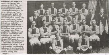
Bendigo Advertiser ''The way we were'' from Monday, December 13, 2004. Sporting history: the Quarry Hill football club, runners-up 1915. Third from left in the back row is Peter Francis Hopley, his brother, John Hopley, is sixth from the left in the front row. Peter Francis Hopley and his wife raised a family of four boys and seven girls at Spring Gully Road, Spring Gully. Three of their sons, Paddy, Frank and Bob, played football for Kennington, with Bob later playing for Golden Square. In the first year he won the best and fairest trophy. Some of the names are: Howard, McEwen and McPherson. Peter Hopley was a blacksmith and during the depression he and a couple of friends walked from Bendigo to Broken Hill to get work in the mines.newspaper, bendigo advertiser, the way we were -
 Bendigo Historical Society Inc.
Document - ALBERT RICHARDSON COLLECTION: STATE BATTERY BELLE VUE ROAD, BENDIGO
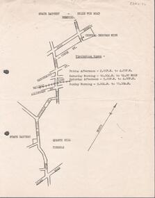
One page document with map sowing the location of the State Battery Quarry Hill. Visitation times are given, presumably it was a tourist destination.bendigo, mining, state battery -
 Coal Creek Community Park & Museum
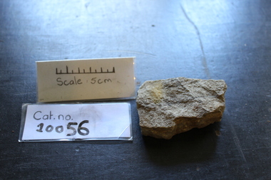
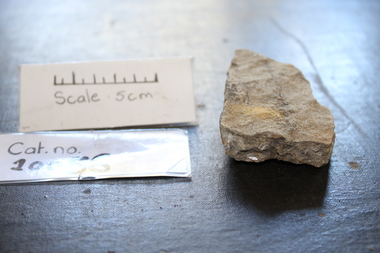
Lump of Quarried Stone
Gray, Lumpy, Crystaled -
 Coal Creek Community Park & Museum
Lump of Quarried Stone
Gray, Lumpy and Crystaled -
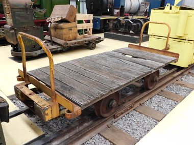
 Puffing Billy Railway
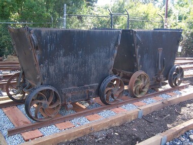
Drop Bottom Clay Trucks - 800mm gauge
These trucks are over 100 years old and are constructed to a similar design to the coke wagons used in the English Midlands region during the 1800's. The trucks were used for the cartage of clay from the quarry to the clay bins, prior to crushing and molding into bricks. These came from Fritsch, Holzer & Company, Brickworks, Hawthorn, Victoria, Australia Historic - Industrial Narrow gauge Railway Fritsch, Holzer & Company Brickworks , Hawthorn, Victoria, Australia - Rolling stock Drop Bottom Clay Trucks - Square like clay truck that has a very deep bottom floor.drop bottom, clay trucks, 2'7.5" gauge, puffing billy, fritsch, holzer & company, brickworks -
 Puffing Billy Railway
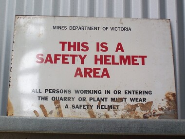
Sign - Safety Helmet Area
Sign - Safety Helmet Area, Mines Dept. of VictoriaHistoric - Safety Sign used by Mines Dept. of Victoriametal sign - Sign - Safety Helmet Area Mines Department of Victoria This is a Safety Helmet Area All persons working in or Entering The Quarry or Plant must wear A Safety Helmetpuffing billy, sign - safety helmet area,, mines dept. of victoria -
 Puffing Billy Railway
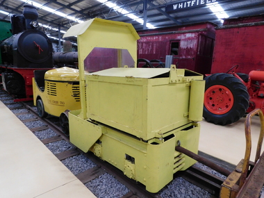
Greenbat Battery Loco, Greenwood & Batley ltd
Greenbat Battery Loco Built by Greenwood & Batley Ltd Builders No. 420363/2 This Greenbat Battery Loco has been loaned to the Museum by the Walhalla Goldfields Railway, who had acquired it in 2013 along with a large quantity of narrow gauge trollies and light rail from Orica’s now closed munitions factory in Melbourne’s western suburbs. The trolley on display was one of two in use from the 1970s. Orica - Deer Park Munitions factory Orica Deer Park in Melbourne’s west has been used since circa 1875 for various forms of manufacturing and storage of chemicals. Although the site is bounded by Ballarat Road, Station Street, Tilburn Road and the Western Ring Road, the current entry point for industrial operations is situated at Gate 6 off Tilburn Road. Operations include: • a specialty chemicals facility producing products for mining services operations • quarry services • other chemical manufacture activities. The Deer Park factory complex is of historical significance as the location of the first plant for the manufacture of high explosives in Australia and has been, for its entire history, the most important, if not only, commercial manufacturer of high explosives in Australia. It commenced operation under the importer Jones Scott and Co, and then the Australian Lithofracteur Company (Krebs Patent), a rival to Nobel's dynamite patent. The factory was producing nitro-glycerine based explosives in Australia only a couple of years after Nobel's Ardeer factory began operating in Scotland. The explosives factories complex is of historical significance for the association with the Australian Lithofracteur Company, Australian Explosives and Chemicals, the Nobel company and later ICIANZ, which grew to become one of the largest explosives, chemical and plastics manufacturers in Australia. It was the pioneer of the industry and retained its dominance through monopolistic practices, taking over most of its competitors in the Australasian region. Substantial parts of the pre-Second World War layout of the site remain which, with a number of significant buildings dating back to the 1920s and '30s, indicate past and present processes of manufacturing, the necessary safety measures required and the integrated nature of the explosives and chemical industry. The narrow gauge tramway, which ran through the explosives section, was a rare survivor of nineteenth century materials-handling methods into the 21st Century. Greenwood & Batley were a large engineering manufacturer with a wide range of products, including armaments, electrical engineering, and printing and milling machinery. They also produced a range of battery-electric railway locomotives under the brand name Greenbat. The works was in Armley, Leeds, UK. Greenbat was the trade name for the railway locomotives built by Greenwood & Batley. The company specialised in electric locomotives, particularly battery-powered types for use in mines and other hazardous environments. Historic - Industrial Narrow Gauge Railway - Battery Locomotive - Orica - Deer Park Munitions factory - Deep park, Victoria, Australia Battery Locomotive - made of iron puffing billy, greenbat battery loco, battery locomotive, industrial narrow gauge railway, orica - deer park munitions factory -
 Puffing Billy Railway
Explosives Wagon, unkown
This 2 foot 6 inch (762mm) gauge wagon was used for carrying explosives and was used with the Greenbat Battery loco. It was donated to the Walhalla Goldfields Railway on long term loan in 2013 along with a large quantity of narrow gauge trollies and light rail from Orica’s now closed munitions factory in Melbourne’s western suburbs. Orica - Deer Park Munitions factory Orica Deer Park in Melbourne’s west has been used since circa 1875 for various forms of manufacturing and storage of chemicals. Although the site is bounded by Ballarat Road, Station Street, Tilburn Road and the Western Ring Road, the current entry point for industrial operations is situated at Gate 6 of Tilburn Road. Operations include: • a specialty chemicals facility producing products for mining services operations • quarry services • other chemical manufacture activities. The Deer Park factory complex The factory complex is of historical significance for the major role it played in Australia's manufacturing and mining industries through the development of progressively more efficient and safer explosives. It also contributed to wartime production in ammunition, initiators and the development of synthetic ammonia production and construction of the Defence Explosives Annexe No 5 (later the Albion Explosives Factory) during World War Two. The factory complex is also of technical significance for the unusual and specialised design of many of the buildings and structures, both in the layout of the works and the individual design of buildings. Blast protection and safety measures such as mounds around the buildings, 'cleanways' and buffer zones between production areas were employed extensively. A characteristic of many production buildings was the elimination of cavities where explosive compounds could lodge. The combination of concrete barriers and light-weight construction was designed to direct explosion debris away from operators or other buildings. The narrow gauge tramway, which ran through the explosives section, is a rare survivor of nineteenth century materials-handling methods. Historic - Industrial Narrow Gauge Railway - Wagon for carrying Explosives at the Orica - Deer Park Munitions factory, Deer park, Victoria, Australia Wagon for carrying explosives made from Timber and steelwagon for carrying explosives, puffing billy, industrial narrow gauge railway, orica - deer park munitions factory, explosives wagon -
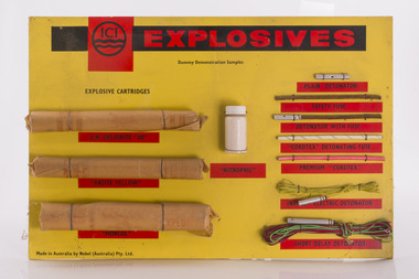 Forests Commission Retired Personnel Association (FCRPA)
ICI Explosives Sampler
The Forests Commission had a large and active engineering branch which was often called upon for major demolition or quarry work. Most overseers, as well as some foresters, were trained in the use of explosives to “blow stuff up” such as removing stumps and rocks from roads. Districts usually had a small powder magazine tucked away in the bush for storage of gelignite and detonators.Sample board showing examples of explosives and detonatorsroad construction and maintenance. -
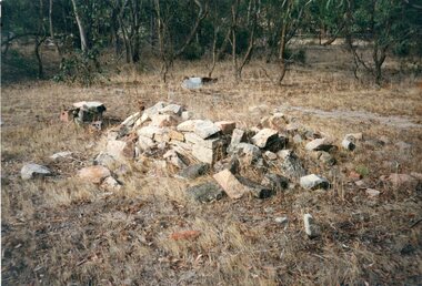 Stawell Historical Society Inc
Photograph, Black Range Quarry Site
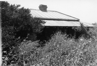
Black Range Quarry SiteOn Reverse Bullocky Mary's House (Mary Honan) On Bullocky Mary Road. Remains of Residence are nearly to Mr Snooks Fence.stawell -
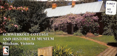 Whitehorse Historical Society Inc.
Pamphlet, Schwerkolt Cottage and Historical Museum, 1/06/1998
Whitehorse City Council publicity pamphlet giving the history of the cottage and the Schwerkolt family. Includes the farm in Separation Street, Northcote. In Mitcham the farm was a 'mixed' one with fruit trees, vines, dairying, poultry, bee hives, wine making and a stone quarry. Includes details of the museum, coloured photographs and locality and site plans.jackschowsky, mary elizabeth, schwerkolt, johann august, richter, paulina, oppel, maria catherina wilhelmine, deep creek road, mitcham, city of whitehorse, nunawading and district historical society inc, city of nunawading, delacombe, rohan (sir), schwerkolt cottage