Showing 342 items
matching reservoir road
-
 Melbourne Tram Museum
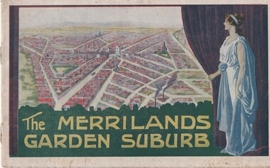
Book, T. M. Burke, "The Merrilands Garden Suburb", late 1919
Book - 12 pages with a fold out double page centre map, centre stapled, titled "The Merrilands Garden Suburb", a real estate marketing brochure for area to the west of the Reservoir rail line, known locally as Merrilands. Marketed on being a gardens suburb to the then Town Planning situation. Contains a suggested loop tram system. Has sales conditions, general information. Marketed by T. M. Burke of 340 Collin St Melbourne. Fold out surveyors map, by Saxil Tuxen, Licensed Surveyor date Oct. 1919. Shows suggested tram routes, reserves, and civic centre.trams, tramways, real estate, reservoir, proposals, new tramway, land -
 Melbourne Tram Museum
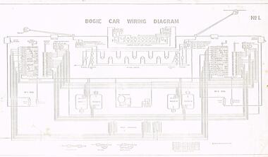
Drawing, Victorian Railways, Bogie Car wiring diagram, c1950's
Set of four drawings of electrical and brake equipment on VR Tramcars. .1 - No. 1 - Bogie car wiring diagram - shows all equipment including lights, compressors, motors and switches. Has a different lighting circuit for the 52 to 54. 4 copies held. .2 - No. 2 - Air and Brake Equipment (Excluding one-man car) - shows all equipment including wipers, conductor's brake valve .3 - No. 3 - Pneumatic Equipment for One-man car - shows all equipment including door engines, emergency valves, emergency reservoirs, door valves and links to controller. .4 - No. 4 - Pneumatic Door Equipment - cars 52 to 54 - including door controller valve positions.trams, tramways, vr class tramcars, victorian railways, brakes, wiring diagrams, one man trams, air compressors -
 Melbourne Tram Museum
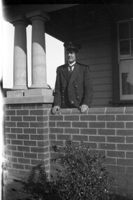
Negative - Set of 2, Ellis Collection, c1940
Set of two Negatives of Inspector W. H. Ellis and his son? at a home in Melbourne. Name from the list of negatives provided. Not known whether this is the same person as other photographs or a relative. See image htd3607 for a photo of the family on a grip car at Edwards Park Reservoirtrams, tramways, inspectors, personnel -
 Melbourne Tram Museum
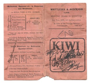
Ephemera - Timetable, Victorian Railways, "Whittlesea & Reservoir Line", Dec. 1926
Timetable - folded brown card titled "Whittlesea & Reservoir Line" dated 6/12/1926 detailing train services on the Reservoir (Whittlesea, currently Mernda) rail line. Shows the trains that ran via Royal Park, or Clifton Hill. The Royal Park services were in effective competition with the tramways. Has an advert for Kiwi Boot Polish.trams, tramways, timetables, vr, reservoir, clifton hill, royal park, inner circle -
 Melbourne Tram Museum
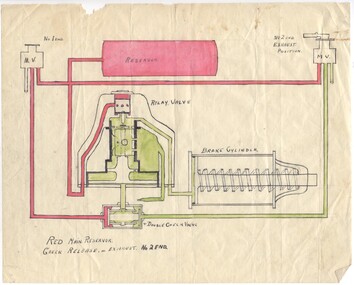
Drawing - air brake system on a Melbourne tram using a self lapping brake and relay valve, Melbourne & Metropolitan Tramways Board (MMTB), 1960's?
Drawing of the air brake system on a Melbourne tram using a self lapping brake and relay valve - the charging and release positions. 89.1 - shows the relay valve in the exhaust position 89.2 - shows the valve in the applied position. Has been drawn in ink on a piece of paper, and the coloured red or green as necessary to show the various positions and state of the valves, reservoir, brake cylinder and pipes.trams, tramways, mmtb, braking, brake valves -
 Bendigo Historical Society Inc.
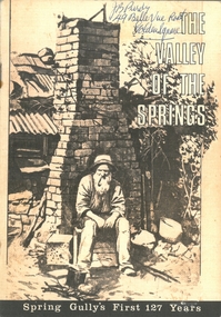
Document - PURDY COLLECTION: VALLEY OF THE SPRINGS
Booklet: 'The Valley of the Springs' a booklet produced to celebrate Spring Gully's First 127 Years. Contains poem about Spring Gully by J.C. Hattam, Photos: St. Phillips Spring Gully, choir practice; garden party to raise funds for St. Phillips, taken on Keck's verandah, Abbotts Tannery, Tannery Lane, school photos, opening of tower on One Tree Hill, a mine at Diamond Hill (un-named) horse drawn vehicles, wood carter, Spring Gully reservoir being enlarged. Written on front in biro 'J.B. Purdy, 49 Bellevue Road, Golden Square. bendigo, history, spring gully -
 Bendigo Historical Society Inc.
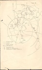
Map - PETER ELLIS COLLECTION: MAP OF WHIPSTICK
Two maps of the Whipstick - Sheet A and Sheet B. Sheet A shows the Whipstick in relation to Bendigo and some surrounding places. Bitumen roads, gravel, forest tracks, Mallee Areas, Flagstaff Hill, fenced in reservations and reservoirs are marked. Also, a circle and part circles of 5-, 10-, 15- and 20-mile radius is marked. North & South are marked. Sheet B is an enlarged area of the Whipstick Scrub area. North and South is marked. There are a number of letters written over both maps.map, bendigo, peter ellis collection, the whipstick, flagstaff hill -
 Surrey Hills Historical Society Collection
Work on paper - Vertical file on Back Creek, Surrey Hills
Back Creek is one of the tributaries of Gardiners Creek. It rises as a spring on the slopes of the hill at the corner of Canterbury Road and Elgar Road in Surrey Hills, the location of a Melbourne Water tower and reservoir. It has been channelled underground from this point in pipes as far as Union Road. South Surrey Park runs along both sides of Back Creek from where the creek crosses Union Rd near Rose Avenue to where it crosses Riversdale Road just west of Through Road. A vertical file containing information about Back Creek in Surrey Hills: 1. 4 colour photos taken in 1983 (1 page). 2. ‘Pipe dreams run their course’, (Boroondara Review ?) 17.4.2013 (1 page). 3. ‘Plan rainchecked for creek impact’, Boroondara Review, 13.3.2013 (2 pages). back creek -
 Bendigo Historical Society Inc.
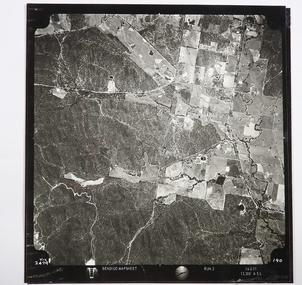
Map - CAMPBELL COLLECTION: BENDIGO AND DISTRICT MAPS
Map. Two aerial photographs of Kangaroo Flat and Lockwood (part). Crusoe Reservoir bottom right corner on Crusoe Road, shows Merindah Road running between Lockwood and Crusoe Roads. Map Name : Bendigo Mapsheet Run 2. 14-2-71, 13,200 A.S.L.. Map shown with NORTH at bottom of page, VIC 2479 at corner. Map 2 continues to the west. A joined copy of both photographs is also included.map, bendigo, agricultural lands -
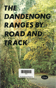 Narre Warren and District Family History Group
Book, Sandra Bardwell, The Dandenong Ranges by Road and Track, 1981
Tour routes in the Dandenong Ranges, including maps.64 p.; 22 cmnon-fictionTour routes in the Dandenong Ranges, including maps.dandenong ranges, tourism, cardinia reservoir, emerald lake park, aura vale lake, crystal brook park, bimbimbie wildlife park, guidebook -
Bendigo Historical Society Inc.
Map - Laminated map of Lake Eppalock at full capacity
John Perry Collection. Laminated copy of map of Lake Eppalock at full capacity. Had highlighter markings of old roads which appear to be still in use. The dam was built by the State Rivers and Water Supply Commission of Victoria. The dam wall height is 45 metres (148 ft) and the main embankment is 1,041 metres (3,415 ft) long. At 100% capacity the dam wall was designed to hold back 304,651 megalitres (6.7014×10¹⁰ imp gal; 8.0480×10¹⁰ US gal) of water. The surface area of Lake Eppalock is 3,011 hectares (7,440 acres) and the catchment area is 2,124 square kilometres (820 sq mi). The controlled spillway is capable of discharging 8,040 cubic metres per second (284,000 cu ft/s). Lake Eppalock supplies both stock and domestic water to the Campaspe irrigation district. It also serves as a water supply to Bendigo and Heathcote and, in more recent times, Ballarat. The lake is a major attraction for those engaging in watersports, with a number of tourist parks and accommodation facilities available. Permissible activities on the lake include high-speed boating, water skiing, sailing, canoeing, fishing and swimming. The lake's water levels were low for approximately eight years between 2002 and 2010 during a prolonged drought, which restricted the amount of recreational activity until rainfall in the latter half of 2010 returned the lake to 100 percent capacity. Built between 1961 and 1964, Lake Eppalock remains the only water storage on the Campaspe River system.map, water, dam, reservoir, eppalock -
Bendigo Historical Society Inc.
Map - Map of Lake Eppalock shoreline when empty
John Perry Collection. Laminated copy of map detailing Lake Eppalock shoreline when empty. Circa 1951. Has colored highlighter lines following roads leading to lake shoreline and various inundated old roads and tracks on lakebed. The dam was built by the State Rivers and Water Supply Commission of Victoria. The dam wall height is 45 metres (148 ft) and the main embankment is 1,041 metres (3,415 ft) long. At 100% capacity the dam wall was designed to hold back 304,651 megalitres (6.7014×10¹⁰ imp gal; 8.0480×10¹⁰ US gal) of water. The surface area of Lake Eppalock is 3,011 hectares (7,440 acres) and the catchment area is 2,124 square kilometres (820 sq mi). The controlled spillway is capable of discharging 8,040 cubic metres per second (284,000 cu ft/s). Lake Eppalock supplies both stock and domestic water to the Campaspe irrigation district. It also serves as a water supply to Bendigo and Heathcote and, in more recent times, Ballarat. The lake is a major attraction for those engaging in watersports, with a number of tourist parks and accommodation facilities available. Permissible activities on the lake include high-speed boating, water skiing, sailing, canoeing, fishing and swimming. The lake's water levels were low for approximately eight years between 2002 and 2010 during a prolonged drought, which restricted the amount of recreational activity until rainfall in the latter half of 2010 returned the lake to 100 percent capacity. Built between 1961 and 1964, Lake Eppalock remains the only water storage on the Campaspe River system.map, eppalock, reservoir, lake, water