Showing 3448 items
matching road bridges
-
 Phillip Island and District Historical Society Inc.
Photograph, 1938
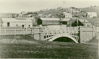
... Phillip Island suspension Bridge - road link between...-island-and-the-bass-coast Phillip Island suspension Bridge - road ...Phillip Island suspension Bridge - road link between Phillip Island and San Remo (the mainland) Part of an album compiled and donated by Mrs Helen Jansson.Phillip Island Suspension Bridge under construction in 1938Descriptive caption adjoining this photo print, also the previous one.local history, photography, photographs, slides, film, civil engineering, bridges, phillip island suspension bridge, black & white photograph, mrs. helen jansson, suspension bridges, phillip island -
 Eltham District Historical Society Inc
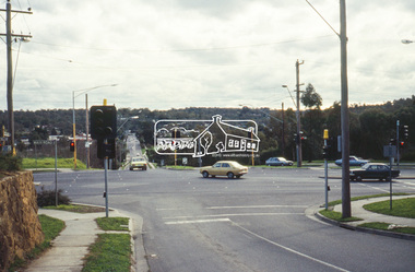
Slide - Photograph, Bridge Street, Eltham, c.June 1990
... Intersection of Main Road and Bridge Streets, Eltham... melbourne Intersection of Main Road and Bridge Streets, Eltham ...Intersection of Main Road and Bridge Streets, Eltham. Before reconstruction of Main Road, this intersection had deep cutting embankments on all four corners. Roadworks and private development have levelled the land on the low side of the road. The Eltham War Memorial was originally located on the north western corner. in 1919. 35mm colour positive transparency (1 of 36) Mount - Agfa CS System grey 8 dotsroads, bridge street, eltham -
 Sunbury Family History and Heritage Society Inc.
Photograph
... along the winding Corkscrew Hill road. The bridge still stands... the winding Corkscrew Hill road. The bridge still stands between ...The single span bluestone bridge is on the Calder Highway at the base of Corkscrew Hill between Gap Road and the town of Gisborne. In the early 1990s the highway was widened and dual carriageways constructed, as a result the traffic no longer travelled along the winding Corkscrew Hill road. The bridge still stands between the two carriageways. A black and white photograph with a cream border of a single arched stone bridge spanning a watercourse. Small bushes are growing in the foreground and there are some buildings dotted across the hill in the middle distance.bridges, corkscrew hill, calder highway -
 Eltham District Historical Society Inc
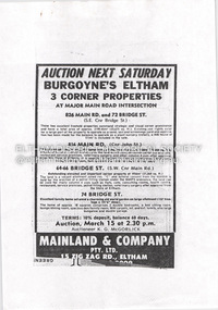
Document - Property Binder, 826 Main Road, Eltham
... minding centre at the corner of Bridge Road and Main Road however... minding centre at the corner of Bridge Road and Main Road however ...Photocopy advertisement, sale three corner properties at Main Road intersection, by Burgoyne family. Newspaper article: Nod for medical centre plan, Diamond Valley News, May 31, 1995 - Nillumbik Council approved plans for medical facility and chiuld minding centre at the corner of Bridge Road and Main Road however not all members of the Planning Special Committee were in support - eventually did not proceed and units were built with the address of 72 Bridge Roadmain road, eltham, property, burgoyne family, medical centre, 72 bridge street, 826 main road, bridge street, child minding centre, don cordell, jim connor, nillumbik planning special committee, tony lazzarotto -
 Eltham District Historical Society Inc
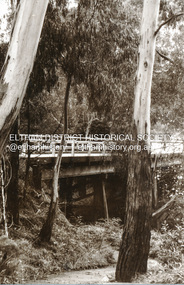
Photograph, Eltham Bridge
... Photograph of bridge, Main Road, Eltham possibly taken... melbourne Photograph of bridge, Main Road, Eltham possibly taken ...Photograph of bridge, Main Road, Eltham possibly taken by Peter Bassett-Smith. No date. eltham, bridge, main road -
 Eltham District Historical Society Inc
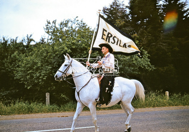
Photograph, Jock Read on 'Popeye', Ersilac Parade, Main Road, Eltham, c.1960, 1960c
... Jock Read riding 'Popeye' south along Main Road approaching... melbourne Jock Read riding 'Popeye' south along Main Road ...Jock Read riding 'Popeye' south along Main Road approaching Bridge Street. Jock acquired 'Popeye' just before the outbreak of WW2. As he was already in the Royal Australian Navy, Jock named the horse after Popeye the Sailor Man. Popeye was a dapple grey, then went white as he aged. Digital file only (Wes's 35mm)don muir collection, eltham, ersilac, ersilac parade, jock read, main road, popeye (horse) -
 Melbourne Tram Museum
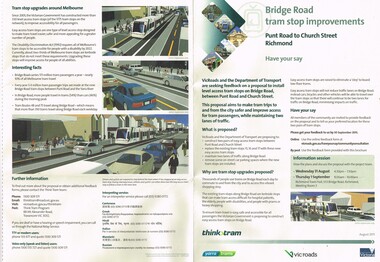
Pamphlet, VicRoads, "Bridge Road tram stop improvements", Sep. 2011
... "Bridge Road tram stop improvements"... off titled "Bridge Road tram stop improvements". giving... + and A4 tear off titled "Bridge Road tram stop improvements ...Pamphlet, printed on cream recycled paper, A3 + and A4 tear off titled "Bridge Road tram stop improvements". giving details of the Punt Road to Church St section of Bridge Road tram line. Installation of two level access tram stops to replace the existing three - Vienna style. Has details on the proposal, the background reasons, inviting people to have their say, information sessions, maps, diagrams and contact details and survey form. 2 copies held.trams, tramways, bridge rd, tram stops, vienna style stops, vicroads, disability services -
 Melbourne Tram Museum
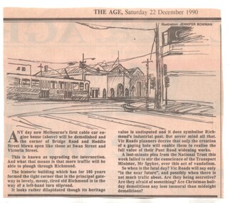
Newspaper, The Age, demolition of the cable tram winding house on the corner of Hoddle and Bridge Road, 22/12/1990 12:00:00 AM
... Hoddle and Bridge Road... Bridge Road... and Bridge Road by VicRoads, to open the areas to traffic, despite... Trams tramways Cable Trams Bridge Road Hoddle St Winding Houses ...Newspaper clipping from The Age, 22/12/1990, about the demolition of the cable tram winding house on the corner of Hoddle and Bridge Road by VicRoads, to open the areas to traffic, despite National Trust pleas.trams, tramways, cable trams, bridge road, hoddle st, winding houses, power house, demolition, national trust -
 Flagstaff Hill Maritime Museum and Village
Document - Map, Department of Lands & Survey, Victoria / Panmure, 1942
... lines, grid lines, names of districts, towns and roads, bridges... lines, grid lines, names of districts, towns and roads, bridges ...This Emergency Edition of the map of Panmure, Victoria, is part of the W.R. Angus Collection. It was printed in 1942 during World War II. It is one of two maps donated to Flagstaff Hill Maritime Village by the family of Doctor William Roy Angus, who served as Surgeon Captain in the Australian Defence Department. The map was compiled for the Dept. of Army by the Dept. of Lands and Survey in Melbourne, prepared by the Australian Section of the Imperial General Staff, which was a British Government body created in 1907 to co-ordinate the defence of Britain and its Empire. It was printed by A.H.Q. Cartographic Company, Survey Corps, which was formed in 1941. The Corp changed its name to L.H.Q. Cartographic Company of Bendigo. In 1947 the name reverted back to the A.H.Q. Cartographic Company until 1955 when it became the A.H.Q. Survey Regiment. The W.R. Angus Collection includes historical medical equipment, surgical instruments and material once belonging to Dr Edward Ryan and Dr Thomas Francis Ryan, (both of Nhill, Victoria) as well as Dr Angus’ own belongings. The Collection’s history spans the medical practices of the two Doctors Ryan, from 1885-1926 plus that of Dr Angus who began practice in 1924. Dr. Angus served with the Australian Department of Defence as a Surgeon Captain during the Second World Was from 1942 to 1945. He served in Ballarat, Victoria, and in Bonegilla, N.S.W. until he suffering from a heart attack just before the war ended. ABOUT THE “W.R.ANGUS COLLECTION” - Doctor William Roy Angus M.B., B.S., Adel., 1923, F.R.C.S. Edin.,1928, was generally known as Dr Roy Angus. His working life included a position as a doctor with the Flying Doctor Service in Australia’s rural and remote areas. After many varied experiences Dr Angus and his family moved to Warrnambool in 1939 where he purchased “Birchwood,” the 1852 home and medical practice of Dr John Hunter Henderson. He was appointed on a part-time basis as Port Medical Officer in Warrnambool and held this position until the 1940’s when the government no longer required the service of a Port Medical Officer. Dr Angus was a surgeon at the Warrnambool Base Hospital 1939-1942. After further studies he commenced practice as an ophthalmologist in Warrnambool, pioneering in artificial eye improvements. He was Honorary Consultant Ophthalmologist to Warrnambool Base Hospital for 31 years and made monthly visits to Portland to perform eye surgery. Dr Angus and his wife Gladys were very involved in Warrnambool’s community with a strong interest in civic affairs. They were both involved in the creation of Flagstaff Hill Maritime Village, including the layout of the gardens. After his death on 28th March 1970 his family requested his practitioner’s plate, medical instruments and some personal belongings be displayed in the Port Medical Office surgery at Flagstaff Hill Maritime Village, and be called the “W. R. Angus Collection”. This Emergency Edition of the Map of Panmure is significant as an example of the documents prepared for the defence of Australia in World War 2. The Map is also significant for its connection between the Australian Army and the involvement of Dr WR Angus as a Surgeon in the Medical Services during World War II. The W.R. Angus Collection is significant for still being located at the site it is connected with, Doctor Angus being the last Port Medical Officer in Warrnambool. The collection of medical instruments and other equipment is culturally significant, being an historical example of medicine, administration, household equipment and clothing from late 19th to mid-20th century. Dr Angus assisted Dr Tom Ryan, a pioneer in the use of X-rays and in ocular surgery. The collection includes Dr Angus’s Army objects and is significant as an example of items issued to Doctors and Surgeons in the Medical Services of the Australian Army in World War IIMilitary map of Panmure, Victoria, Australia; part of the W.R. Angus Collection. Rectangular coloured map on cream paper for the Australian Army. Details include sea, waterways and land, contour lines, grid lines, names of districts, towns and roads, bridges, swamps, rail lines, cuttings, tracks, buildings (including blacksmiths), pumps, lighthouses, telegraph, telephones and electric transmission lines, and fire stations. The map has margin notes that include distances in miles to nearby towns. The map was compiled for the Dept. of Army by the Dept. of Lands and Survey in Melbourne, prepared by the Australian Section, Imperial General Staff and printed by A.H.Q. Cartographic Company, Melbourne in 1942. Crown Copyright Reserved. Inscriptions in red print state that it is and Emergency Edition and an Official document. An oval purple stamp includes the price.Printed in black; 'Victoria / Panmure", "No. 930 / Zone 6" Printed in red; “EMERGENCY EDITION”, “THIS MAP IS AN OFFICIAL DOCUMENT. IF FOUND, IT MUST BE HANDED / IN TO THE NEAREST MILITARY HEADQUARTERS OR POLICE STATION” Stamped: within concentric ovals (“- - - FOR SALE / PRICE 2/- / - - - - - OF THE ARMY”)flagstaff hill, warrnambool, flagstaff hill maritime museum, maritime museum, shipwreck coast, flagstaff hill maritime village, great ocean road, dr w r angus, dr ryan, warrnambool base hospital, flying doctor, surgeon captain, australian department of defence, royal australian army, world war 2, map panmure 1942, roy angus, port medical officer, nhill base hospital, military map, emergency map, military service australian army, department of army, department of lands and survey, a.h.q. cartographic company melbourne, panmure 1942, australian section, imperial general staff -
 Flagstaff Hill Maritime Museum and Village
Document - Map, Department of Lands & Survey, Victoria / Port Campbell, 1942
... lines, grid lines, names of districts, towns and roads, bridges..., names of districts, towns and roads, bridges, swamps, rail lines ...This Emergency Edition of the map of Port Campbell, Victoria, is part of the W.R. Angus Collection. It was printed in 1942 during World War II. It is one of two maps donated to Flagstaff Hill Maritime Village by the family of Doctor William Roy Angus, who served as Surgeon Captain in the Australian Defence Department. The map was compiled for the Dept. of Army by the Dept. of Lands and Survey in Melbourne, prepared by the Australian Section of the Imperial General Staff, which was a British Government body created in 1907 to co-ordinate the defence of Britain and its Empire. It was printed by A.H.Q. Cartographic Company, Survey Corps, which was formed in 1941. The Corp changed its name to L.H.Q. Cartographic Company of Bendigo. In 1947 the name reverted back to the A.H.Q. Cartographic Company until 1955 when it became the A.H.Q. Survey Regiment. The W.R. Angus Collection includes historical medical equipment, surgical instruments and material once belonging to Dr Edward Ryan and Dr Thomas Francis Ryan, (both of Nhill, Victoria) as well as Dr Angus’ own belongings. The Collection’s history spans the medical practices of the two Doctors Ryan, from 1885-1926 plus that of Dr Angus who began practice in 1924. Dr Angus served with the Australian Department of Defence as a Surgeon Captain during the Second World Was from 1942 to 1945. He served in Ballarat, Victoria, and in Bonegilla, N.S.W. until he suffering from a heart attack just before the war ended. ABOUT THE “W.R.ANGUS COLLECTION” - Doctor William Roy Angus M.B., B.S., Adel., 1923, F.R.C.S. Edin.,1928, was generally known as Dr Roy Angus. His working life included a position as a doctor with the Flying Doctor Service in Australia’s rural and remote areas. After many varied experiences Dr Angus and his family moved to Warrnambool in 1939 where he purchased “Birchwood,” the 1852 home and medical practice of Dr John Hunter Henderson. He was appointed on a part-time basis as Port Medical Officer in Warrnambool and held this position until the 1940’s when the government no longer required the service of a Port Medical Officer. Dr Angus was a surgeon at the Warrnambool Base Hospital 1939-1942. After further studies he commenced practice as an ophthalmologist in Warrnambool, pioneering in artificial eye improvements. He was Honorary Consultant Ophthalmologist to Warrnambool Base Hospital for 31 years and made monthly visits to Portland to perform eye surgery. Dr Angus and his wife Gladys were very involved in Warrnambool’s community with a strong interest in civic affairs. They were both involved in the creation of Flagstaff Hill Maritime Village, including the layout of the gardens. After his death on 28th March 1970 his family requested his practitioner’s plate, medical instruments and some personal belongings be displayed in the Port Medical Office surgery at Flagstaff Hill Maritime Village, and be called the “W. R. Angus Collection”. This Emergency Edition of the Map of Port Campbell is significant as an example of the documents prepared for the defence of Australia in World War 2. The Map is also significant for its connection between the Australian Army and the involvement of Dr WR Angus as a Surgeon in the Medical Services during World War II. The W.R. Angus Collection is significant for still being located at the site it is connected with, Doctor Angus being the last Port Medical Officer in Warrnambool. The collection of medical instruments and other equipment is culturally significant, being an historical example of medicine, administration, household equipment and clothing from late 19th to mid-20th century. Dr Angus assisted Dr Tom Ryan, a pioneer in the use of X-rays and in ocular surgery. The collection includes Dr Angus’s Army objects and is significant as an example of items issued to Doctors and Surgeons in the Medical Services of the Australian Army in World War IIMilitary map of Port Campbell, Victoria, Australia; part of the W.R. Angus Collection. Rectangular coloured map on cream paper for the Australian Army. Details include sea, waterways and land, contour lines, grid lines, names of districts, towns and roads, bridges, swamps, rail lines, cuttings, tracks, buildings (including blacksmiths), pumps, lighthouses, telegraph, telephones and electric transmission lines, and fire stations. The map has margin notes that include distances in miles to nearby towns. The map was compiled for the Dept. of Army by the Dept. of Lands and Survey in Melbourne, prepared by the Australian Section, Imperial General Staff and printed by A.H.Q. Cartographic Company, Melbourne in 1942. Crown Copyright Reserved. Inscriptions in red print state that it is and Emergency Edition and an Official document. An oval purple stamp includes the price.Printed in black; 'Victoria / Port Campbell", "No. 932 / Zone 6" Printed in red; “EMERGENCY EDITION”, “THIS MAP IS AN OFFICIAL DOCUMENT. IF FOUND, IT MUST BE HANDED / IN TO THE NEAREST MILITARY HEADQUARTERS OR POLICE STATION” Stamped: within concentric ovals (“- - - FOR SALE / PRICE 2/- / - - - - - OF THE ARMY”)flagstaff hill, warrnambool, flagstaff hill maritime museum, maritime museum, shipwreck coast, flagstaff hill maritime village, great ocean road, dr w r angus, dr ryan, warrnambool base hospital, nhill base hospital, flying doctor, surgeon captain, map port campbell 1942, roy angus, port medical officer, military map, emergency map, australian department of defence, royal australian army, military service australian army, department of army, department of lands and survey, world war 2, a.h.q. cartographic company melbourne, australian section, imperial general staff, port campbell 1942 -
 Clunes Museum
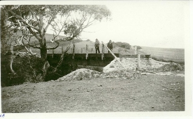
Photograph, CIRCA 1941
... BUILDING OF BRIDGE OVER MOUNT CREEK ON ROAD TO MOUNT... OF BRIDGE OVER MOUNT CREEK ON ROAD TO MOUNT BECKWORTH, BRIDGE NOW ...BUILDING OF BRIDGE OVER MOUNT CREEK ON ROAD TO MOUNT BECKWORTH, BRIDGE NOW CLOSED TO TRAFFIC.PHOTOCOPY OF PHOTO OF BUILDING BRIDGE OVER MOUNT CREEK TO MOUNT BECKWORTH. CIRCA 1941 TWO MEN IN WORK WEAR STANDING ON BRIDGElocal history, photography, photographs, bridges -
![Newspaper Clipping - Digital Image, Bridge-over-rail job to cost $254,000, 1974 [Main Street Greensborough], 24/09/1974](/media/collectors/4f729f5697f83e03086015b8/items/5eb5f55721ea671f1807c4cf/item-media/5eb5f5e021ea671f18088f90/item-fit-380x285.jpg) Greensborough Historical Society
Greensborough Historical SocietyNewspaper Clipping - Digital Image, Bridge-over-rail job to cost $254,000, 1974 [Main Street Greensborough], 24/09/1974
... In 1974 the proposed road over rail bridge in Main Street...Greensborough Historical Society 34A Glenauburn Road Lower ...In 1974 the proposed road over rail bridge in Main Street Greensborough was estimated to cost $254,000. The reconstruction of the bridge was necessary for the duplication of the rail line between Macleod and Greensborough.News clipping, black and white text. hurstbridge rail line, greensborough station, main street greensborough -
Eltham District Historical Society Inc
Document - Folder, Shanhun, Cheon and James
... Shanhuns Road Cottles Bridge... information on the naming of Shanhuns Road, Cottles Bridge. Photocopy... information on the naming of Shanhuns Road, Cottles Bridge. Photocopy ...Cheon Shanhun lived between Wattle Glen and Hurstbridge from about 1870 to 1900. His son James settled in Panton Hill. Contents Letter Alison Connett, 27 December 1993, seeking information on the naming of Shanhuns Road, Cottles Bridge. Photocopy of photograph, group of people c1929, Mrs Jim Shanhun identified.Newspaper clippings, A4 photocopies, etccheong shanhun, james shanhun, shanhuns road cottles bridge, panton hill -
 Clunes Museum
Photograph
... AT CLUNES - GOVERNMENT BRIDGE, CRESWICK ROAD. EBERHARDS SOFT DRINK... OF GOVERNMENT BRIDGE OVER CRESWICK CREEK ON CRESWICK ROAD, CLUNES ...PHOTOGRAPH OF GOVERNMENT BRIDGE OVER CRESWICK CREEK ON CRESWICK ROAD, CLUNES. PHOTOGRAPH DONATED BY CRESWICK MUSEUM. COPIED BY MR. SEMMENS FROM AN EARLIER PHOTOGRAPH.BLACK AND WHITE PHOTOGRAPH OF BRIDGE OVER CRESWICK CREEK AT CLUNES - GOVERNMENT BRIDGE, CRESWICK ROAD. EBERHARDS SOFT DRINK FACTORY IN CENTRE OF PHOTOGRAPH.local history, photography, photographs -
 Whitehorse Historical Society Inc.
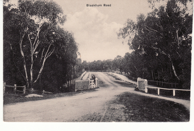
Postcard - Black and white postcard, Blackburn Road Bridge in Blackburn. Circa 1908, C.1914
... Blackburn Road Bridge in Blackburn. Circa 1908.... Creek bridge looking south featuring Bridge over unmade road... Creek bridge looking south featuring Bridge over unmade road ...Black and white postcard of Blackburn Road at Gardiner's Creek bridge looking south featuring Bridge over unmade road. Entitled 'Blackburn Road'hooke, janet emily, albert arthur, blackburn road, blackburn -
 Lakes Entrance Historical Society
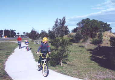
Photograph - Cycle pathway between Bullock Island and North Arm Bridge, L E Tidy Town Committee, Lakes Entrance Victoria, 1994 c
... and cycle pathway between Bullock Island Road and North Arm Bridge... Bullock Island Road and North Arm Bridge Lakes Entrance Victoria ...Colour photograph of three cyclists on shared pedestrian and cycle pathway between Bullock Island Road and North Arm Bridge Lakes Entrance Victoria transport, recreation, roads and streets -
Glen Eira Historical Society
Book - Local Government Act First Report of the Assistant Commissioner of Roads and Bridges
... , First Report of the Assistant Commissioner of Roads and Bridges... Steavenson, Assistant Commissioner of Roads and Bridges under s330 ...This file contains 1 item: 1/The Local Government Act, First Report of the Assistant Commissioner of Roads and Bridges, printed by order of the Victorian Legislative Assembly on 08/03/1865. The document is the first annual report of John Steavenson, Assistant Commissioner of Roads and Bridges under s330 of the Local Government Act no. 176 (1863), and relates to transactions which took place from 02/09/1863 to 31/12/1864. The report outlines operations carried out by the Department of Roads and Bridges in this period. In the Glen Eira area this includes: separating electoral subdivisions of single districts (Moorabbin), adding detached portions of territory to road districts and shires (Caulfield), appointing of and altering in polling places, appointing of polling places for ridings of shires and subdivisions of road districts (Moorabbin), preparing and transmitting of forms of books also of pro forma accounts for guidance of local bodies in keeping their accounts, appointment of main roads, construction of a main road, ‘Dandenong’, in the Caulfield and Gardiner districts, proclaiming of Common Toll Roads, names of and security given by Managers of Common Toll Roads. The report also gives some information about the Shire of Caulfield, which contained 24 road districts and 340 rate payers in 8¼ square miles, and the Shire of Moorabbin, which contained 62 road districts and 713 rate payers in 30 square miles.local government act, assistant commissioner of roads and bridges, legislative council, caulfield historical soceity, steavenson john, sullivan j. f. the honourable, caulfield, moorabbin, road districts, point nepean road, nepean highway, dandenong road, princes highway, brown edwin, osher joseph, cosgrove john, ferres john, roads and bridges offices, caulfield roads district, moorabbin roads district, road construction and maintenance, roads and streets, acts of parliament -
 Nillumbik Shire Council
Print (sugarlift etching): Jan SENBERGS (b.1939 Lativia, arrived AUS 1950), Jan Sensbergs, 'New Jersey - rust belt' from the 'Baldessin & Friends' commemorative folio, 2016
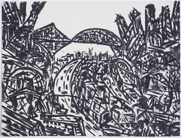
... ) scene - bridges, roads, buildings, in thick black brushstrokes... of an urban (cityscape - New Jersey) scene - bridges, roads, buildings ...Jan Senbergs was born in Riga, Latvia, in 1939 and came to Australia when he was ten. Senbergs’ work has been characterised by a simple and bold aesthetic. From lush landscapes to barren urban spaces, his body of work signifies an artist who has continually experimented with shape, form and motif, a fundamental humanist vision, a finely-honed sense of the absurd, and a rigorous studio practice spanning printmaking, drawing and painting. Senbergs is Baldessin's exact contemporary. He was also born in Europe and fled his homeland because of the war, arriving in Melbourne in 1950. Like George, Senbergs also worked at the RMIT and in 1973 represented Australia at the Bienal de Sao Paulo. Senbergs first met George when he was living in St. Kilda. George asked if he could screen print his 'Argus' catalogue for a show at the gallery in the Argus building. George Baldessin (1939-1978) was born in San Biagio di Callalta, in the Veneto in Northern Italy and arrived in Australia ten years later. A printmaker and sculptor he built his bluestone studio at St Andrews (Nillumbik) in 1971. The bluestone studio was hand built by George, his partner Tess and the three Hails brothers, Rob, Doug and Don. Made of recycled materials the studio today contains all of George’s equipment including the large press, which he modelled himself with the help of Neil Jeffrey (Enjay Presses). George won many prizes throughout his career and is represented in many of Australia's public art collections including his famous 'Pears' sculpture in front of the National Gallery of Australia, Canberra. In 1975 he represented Australia in the Sao Paulo Biennale, before living and working in Paris until his return to St Andrews in 1977. In 1978 George was killed in a car accident aged 39 years. In 2001 Tess returned to St Andrews to reclaim the run-down studio and reconstitute it as The Baldessin Press & Studio - a printmaking retreat. It operates in George’s memory, so that artists may continue to create, perpetuating the generous spirit of George.'New Jersey - rust belt' is one of eight prints in the 'Baldessin & Friends commemorative folio. The folio was conceived by Tess Edwards as a fundraising initiative in celebration of the The Baldessin Press & Studio's fifteen year anniversary, and as a way to honour George Baldessin's memory. The Baldessin Press & Studio is a not-for-profit organisation created in memory of the late George Baldessin (1939-1978), whose original studio is now open to the public for creative use and as a practical legacy to living artists. The Studio is located in St Andrews, Nillumbik. The folio is a unique coming together of seven very different and acclaimed artists who are connected by their friendship to the missing eighth member, George Baldessin. This print finds its' origins in the time Senbergs spent at Harvard in America in 1989-90. In the context of Baldessin it explores an industrial urban surreal vision that was common to both artist. The image captures the life force of the city revealing the keen and observant eye of Jan Senbergs. Similar in sensibility to his large scale charcoal drawings of the 1990s, the artwork is not only a record of what the artist sees, but of what interest him. By following the movement of each line the viewer can witness the artist's eye travelling through, over and around each element of the urban landscape. The scale is deceptive with the image bled to the full-size of the sheet of paper like a microcosm of a much bigger whole. sugar lift etching of an urban (cityscape - New Jersey) scene - bridges, roads, buildings, in thick black brushstrokes. The image is busy; full of energy and movement. A bleed print in which the paper barely contains the city scape. In pencil (handwritten): top centre: left '14/25' (edition); centre 'New Jersey-Rustbelt' (title); right 'Jan Senbergs' (signature); print, sugarlift etching, urban landscape, ekphrasis2018, new jersey, line, rust belt -
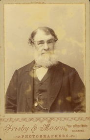 Kew Historical Society Inc
Photograph - John Padbury
... Obverse: “Frisby & Mason / Photographers / 134 Bridge Road... / Photographers / 134 Bridge Road Richmond”. Reverse: “John Padbury ...Padbury’s Funeral Parlour in Kew was the earliest business of its kind in what is now the City of Boroondara. It was established by John Padbury in 1859. Following his death, the company was renamed A W Padbury & Co. John Padbury was involved in meetings in 1861, calling for Kew to become an independent municipality. In 1863, he argued that a lunatic asylum would bring business to shopkeepers. His company was located at 13 Cotham Road, next to the rear entrance of the Kew Police Station. The two-storey building is still [in 2023] extant. Members of the Padbury family married into a number of pioneer Kew families including the Whitmans and Morgans. Rare portrait of a significant Kew pioneerOriginal print positive 'cabinet card'. Portrait of John Padbury, first undertaker in Boroondara. Obverse: “Frisby & Mason / Photographers / 134 Bridge Road Richmond”. Reverse: “John Padbury / founder of Padbury Undertakers Cotham Rd Kew / died 90 yrs / Whitman”funeral parlours. -- kew (vic.), a w padbury, john padbury, businesses -- cotham road -- kew (vic.) -
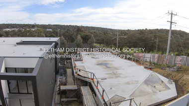 Eltham District Historical Society Inc
Photograph, Peter Pidgeon, 825 Main Road, Eltham, 2 Aug. 2022
... View over 825 Main Road development looking down Bridge... melbourne View over 825 Main Road development looking down Bridge ...View over 825 Main Road development looking down Bridge Street. The development on this site commenced in early 2017. Born Digitaleltham, main road, bridge street -
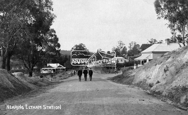 Eltham District Historical Society Inc
Negative - Photograph, Nearing Eltham Station, c.1904
... Eltham, Main Road, looking north from Bridge Street. Gahan... melbourne Eltham, Main Road, looking north from Bridge Street. Gahan ...Eltham, Main Road, looking north from Bridge Street. Gahan house on left. Bakery on right at corner of York Street.This photo forms part of a collection of photographs gathered by the Shire of Eltham for their centenary project book,"Pioneers and Painters: 100 years of the Shire of Eltham" by Alan Marshall (1971). The collection of over 500 images is held in partnership between Eltham District Historical Society and Yarra Plenty Regional Library (Eltham Library) and is now formally known as the 'The Shire of Eltham Pioneers Photograph Collection.' It is significant in being the first community sourced collection representing the places and people of the Shire's first one hundred years.Digital image 4 x 5 inch B&W Negsepp, shire of eltham pioneers photograph collection, eltham, main road, gahan house, gahan, york street -
 Melbourne Tram Museum
Magazine, Victorian Railways, "Alterations at Epsom Road Newmarket", Jun. 1930
... of the rail over road/tram bridge in Epsom Road, Newmarket to replace... of the rail over road/tram bridge in Epsom Road, Newmarket to replace ...Photocopy of pages 361 and 365 Victorian Railways Magazine, July 1925 and page 485 of September 1925 about the construction of the rail over road/tram bridge in Epsom Road, Newmarket to replace the level crossing. Titled: "Alterations at Epsom Road Newmarket" and "Lifting 28-ton Girders an all-night job!" Gives details and photographs of the work and how financed. Sheets have been stapled together.trams, tramways, victorian railways, epsom road, level crossings, newmarket -
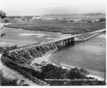 Lakes Entrance Historical Society
Postcard - North Arm bridge Lakes Entrance Victoria, 1920c
... spanning the North Arm, showing the bridge and abutments,road... the North Arm, showing the bridge and abutments,road to bridge from ...Also 2x identical fade P)1151-2,3Black and white miniature postcard of the concrete bridge spanning the North Arm, showing the bridge and abutments,road to bridge from Kalimna, and post and rail fences along road, grass covered mud flats with Club Hotel, Methodist Church and Maranui Guesthouse in distance amongst other buildings. Cunninghame Arm and sand hummocks in far distance. Sandbars visible in North Arm. Lakes Entrance VictoriaPrincess highway Lakes Entrancebridges, coast, religion, hotels, guesthouses -
 City of Ballarat Libraries
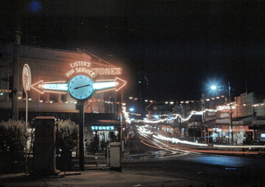
35mm Slide, Neon lights and traffic in the streets of Ballarat circa 1950s
... Lister's petrol station at the corner of Main Road... of Main Road and Bridge streets. The petrol station replaced ...Lister's petrol station at the corner of Main Road and Bridge streets. The petrol station replaced Levy's Vegetable and Fruit Market circa 1940s. Mrs Bon Strange and her husband Bert were well known Ballarat residents. When Mrs Strange died some years ago, her extensive slide collection was sorted through and those relevant to Ballarat were gifted to the Ballarat Library. -
 Ringwood and District Historical Society
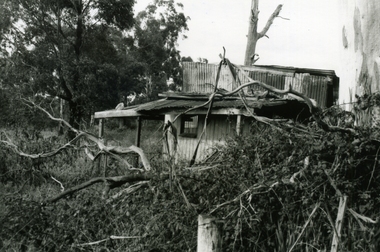
Photograph-B&W, Wantirna Road Shack next to Dandenong Creek on East Side of Wantirna Road (near the bridge), 6/07/1989
... Wantirna Road (near the bridge).... of Wantirna Road (near the bridge). Has been there many years - maybe... to Dandenong Creek on East Side of Wantirna Road (near the bridge). Has ...Wantirna Road Shack next to Dandenong Creek on East Side of Wantirna Road (near the bridge). Has been there many years - maybe 40 and it is still there (18.9.1989). (Note this is NOT part of Hill's dairy but was in the same series of photographs so kept together).A shack next to Dandenong Creek / East side of Wantirna Road / Has been there many years - maybe 40 / It is still there (18.9.89) -
 Hume City Civic Collection
Photograph, c 1980s
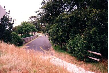
... macedon street road bridge... asphalted surface of the road across the bridge is cut off by a low... macedon street road bridge george evans collection A coloured ...The stone bridge was the only entry into Sunbury on the eastern side of the town and was in use until the road was re-routed and widened in the 1970s.A coloured photograph of the roadway over the Macedon Street bridge which spans Jacksons Creek. There is a grassy area in the foreground with trees growing either side of the bridge. The narrow asphalted surface of the road across the bridge is cut off by a low stone wall.stone bridges, jacksons creek, macedon street road bridge, george evans collection -
 Eltham District Historical Society Inc
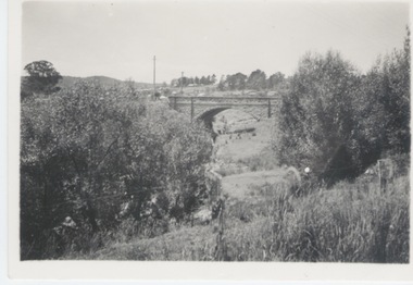
Negative - Photograph, J.A. McDonald, Eltham-Diamond Creek Road, 21 Sep 1959
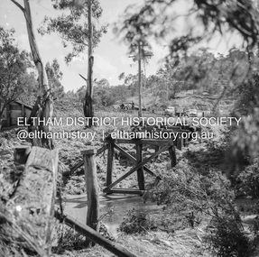
... Wattletree Road Bridge...Bridge construction Eltham-Diamond Creek road over... melbourne Bridge construction Eltham-Diamond Creek road over ...Bridge construction Eltham-Diamond Creek road over the Diamond Creek (Wattletree Road), Eltham, September 1959 After some delay in receiving funds, work started on the bridge approaches in early September 1959. Traffic was still using the old bridge upstream. On Sunday, 20 September 1959, heavy flooding occurred in the stream and at 3:53 pm the old bridge was washed out. This photo was taken the day after. To the left is the Diamond Creek side abutment for the new Wattletree Road bridge under construction. Where the trucks are parked is near the present-day intersection with Progress Road. At the time Progress Road did not exist and was merely a road reserve on the map. The bridge was originally built as a replacement for an older private bridge built by a man named Foley around 1880. In 1911 Heidelberg and Eltham agreed to share the costs to build a new bridge. Construction began in June 1915 and it was officially opened by Cr. Taylor on Cup Day, November 1915.Record of various Shire of Eltham infrastructure works undertaken during the period of 1952-1962 involving bridge and road reconstruction projects, sometimes with Eltham Shire Council Project Reference numbers quoted. It was during this period that a number of significant improvements were made to roads and new bridges constructed within the shire that remain in place as of present day (2022). In many situations, the photos provide a tangible visible record of infrastructure that existed throughout the early days of the Shire. The album was put together by or under the direction of the Shire Engineer, J.A. McDonald.infrastructure, shire of eltham, bridge construction, bridge, diamond creek (creek), eltham, eltham north, glen park bridge, 1959-09-21, flood damage, wattletree road bridge -
 Eltham District Historical Society Inc
Album - Photograph, J.A. McDonald, General; Albion Street and Eltham-Yarra Glen Road, Oct. 1955
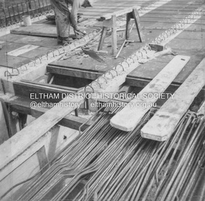
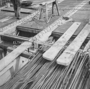
... General – Country Roads Board Albion Street bridge over... melbourne General – Country Roads Board Albion Street bridge over ...General – Country Roads Board Albion Street bridge over Moonee Ponds Creek, Brunswick West Deck Forms October 1955Record of various Shire of Eltham infrastructure works undertaken during the period of 1952-1962 involving bridge and road reconstruction projects, sometimes with Eltham Shire Council Project Reference numbers quoted. It was during this period that a number of significant improvements were made to roads and new bridges constructed within the shire that remain in place as of present day (2022). In many situations, the photos provide a tangible visible record of infrastructure that existed throughout the early days of the Shire. The album was put together by or under the direction of the Shire Engineer, J.A. McDonald.infrastructure, road construction, shire of eltham, 1955-10, albion street, bridge construction, country roads board, benchmark studies, brunswick west, moonee ponds creek -
 Eltham District Historical Society Inc
Album - Photograph, J.A. McDonald, General; Albion Street and Eltham-Yarra Glen Road, Oct. 1955
... General – Country Roads Board Albion Street bridge over... melbourne General – Country Roads Board Albion Street bridge over ...General – Country Roads Board Albion Street bridge over Moonee Ponds Creek, Brunswick West Deck Forms October 1955Record of various Shire of Eltham infrastructure works undertaken during the period of 1952-1962 involving bridge and road reconstruction projects, sometimes with Eltham Shire Council Project Reference numbers quoted. It was during this period that a number of significant improvements were made to roads and new bridges constructed within the shire that remain in place as of present day (2022). In many situations, the photos provide a tangible visible record of infrastructure that existed throughout the early days of the Shire. The album was put together by or under the direction of the Shire Engineer, J.A. McDonald.infrastructure, road construction, shire of eltham, 1955-10, albion street, bridge construction, country roads board, benchmark studies, brunswick west, moonee ponds creek -
Melbourne Tram Museum
Pamphlet, Public Transport Victoria (PTV), "Buses replace trams - route 48, 75, 78", Jan 2021
... Bridge Road...Issued for track renewal and overhead work in Bridge Road... Issued for track renewal and overhead work in Bridge Road between ...Issued for track renewal and overhead work in Bridge Road between Chapel St and Burwood Road, between 3 January and 16 January 2021. Gives details of the replacement and alternative bus routes. Produced by Yarra Trams and the PTV.Yields information about track work in Bridge Road Richmond early 2021Pamphlet - full colour DL 4 fold.trackwork, tramways, bridge road, route 48, route 75, route 78