Showing 11853 items
matching roads for victoria
-
 Eltham District Historical Society Inc
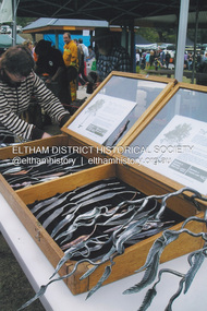
Photograph, Fay Bridge, The Tree Project, 2009
... Memorial Pavilion, 160 Chadds Creek Road, Strathewen, Victoria.... Memorial Pavilion, 160 Chadds Creek Road, Strathewen, Victoria. Fay ...Australia's worst natural disaster, fed by extreme temperatures, tornado-like wind speeds and tinder-dry land, culminated in the disaster we now know as Black Saturday, February 7, 2009. Before the sun would set on the blackest day in Australia's history, thousands of hectares would become blackened landscape and an unparalleled loss of lives could only mean that many areas would never be the same again. To remember the people lost to the devastating Black Saturday fires of 2009 and our brave CFA men and women who battled the elements to protect our towns, the Australian Blacksmiths Association (Victoria) Inc. invited blacksmiths from across the country and around the world to contribute to the creation of a steel gumtree. The Blacksmiths' Tree, as it came to be called, was erected on February 14, 2014. Five years in the making, this 10m high stainless steel and copper tree was forged with love and care by hundreds of blacksmiths across 20 countries. It stands in the township of Strathewen, Victoria, Australia to remember all of those who perished in the Black Saturday fires of 2009, those who fought the fires and those who continue to live their lives with hope and courage. The tree stands at the Peter Avola Memorial Pavilion, 160 Chadds Creek Road, Strathewen, Victoria.fay bridge collection, black saturday, kinglake, victorian bushfires - 2009, the tree project -
 Mont De Lancey
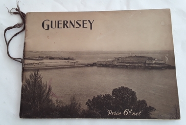
Booklet, The Star and Gazette Company Ltd, The Bailiwick of Guernsey, 1921
... , Victoria Road, Wandin North, Victoria, Australia. With Compliments.'...'. It was given to 'Mr.W.T. Sebire, Victoria Road, Wandin North, Victoria ...A historical descriptive booklet describing the charms and amenities of the wonderful island of Guernsey and all it has to offer. It includes archaeology, schools and colleges, churches, yachting, agriculture, sports, the growing industry. It has small sections on Alderney and Sark.A slim rectangular brown toned softcover booklet with Guernsey printed in black lettering at the top of the front cover and Price 6d. net printed in white lettering at the bottom right. The front and back covers depict a large overall scene of Guernsey from the land looking over the water. The Bailiwick of Guernsey: (The Islands of Guernsey, Alderney and Sark) is printed on the title page with a sepia coloured photograph of the reception of their majesties the King and Queen, and Princess Mary on the occasion of their visit, July11, 1921. There are many black and white photographs throughout the booklet. It has brown thin cord tied on the spine. 24p.non-fictionA historical descriptive booklet describing the charms and amenities of the wonderful island of Guernsey and all it has to offer. It includes archaeology, schools and colleges, churches, yachting, agriculture, sports, the growing industry. It has small sections on Alderney and Sark.history booklet, guernsey history -
 Orbost & District Historical Society
pamphlets, Princes Freeway - Orbost Section, 1976
... roads in Victoria between 1913 and 1983. It was succeeded... for the construction and maintenance of main roads in Victoria between 1913 ...Opened by the Hon. J A Rafferty, Minister for Transport, 25 November 1976, the bridge was the first of four bridges to be built as part of the freeway bypass of Orbost. Construction cost $2.4 million. This construction was an important development along the Princes Highway corridor through East Gippsland. The original highway approached the Snowy River at a very poor alignment, and several serious accidents had occurred at the Orbost end. In times of heavy flood, the highway on both sides of the river had been cut by floodwaters and during the 1971 floods, the highest ever recorded, the river was a mile wide at the crossing. Construction of the bridges commenced in January 1975, with an expectation to open the bridge across the Snowy River as soon as possible. Less than two years later, on 25 November 1976, the bridge across the Snowy River was opened to traffic, allowing the old bridge to be demolished. The remainder of the Orbost Bypass, both the floodplain crossings and the eastern section around the township itself, was declared ‘Princes Freeway’ and opened to traffic in December 1977. (ref http://mrv.ozroads.com.au) The Country Roads Board was the government authority for the construction and maintenance of main roads in Victoria between 1913 and 1983. It was succeeded by the Road Construction authority on 1 July 1983 and later merged with the Road Traffic Authority on July 1 1989 to form the Roads Corporation. James Cameron, an Orbost farming pioneer and Member of the Legislative Assembly, fathered the Country Roads Board. The opening of this Snowy River Bridge was an important development in the accessibility to the township of Orbost.Three coloured Country Roads pamphlets for the 'Princes Freeway - Orbost Section". On the front is a coloured photograph of the new construction over the Snowy River at Orbost. Inside is a program for a ceremony for the opening of the new Snowy River Bridge. There is also a black print map of the project. -
 Warrnambool and District Historical Society Inc.
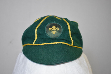
Clothing - Cap, scouts, Circa 1950
... and in Otway Road). Cub scouts in Victoria are aged between 8 and 10. ... and in Otway Road). Cub scouts in Victoria are aged between 8 and 10 ...This cap belonged to Mark Pullen, a cub scout from Highton, Geelong, Victoria. No information is available on Mark Pullen. In Warrnambool there are three scout groups – Allansford, Norfolk (scout hall at the corner of Raglan Parade and Kepler Street) and Tooram (scout halls at the corner of Timor and Banyan Streets and in Otway Road). Cub scouts in Victoria are aged between 8 and 10. This cap has no known local provenance but is a useful item for display.This is a cap made of dark green wool with narrow gold braid dividing the crown into six sections. A button is missing from the top. The badge on the cap is a circular patch with the scout emblem in yellow and green. The cap is lined with black material with a white centre.Hills Hats Size 7 Name: Mark Pullen Group: 1st Highton Fabric Content all wool Scout Approved Product Made Expressly for the Scout Association of Australia Made in Singapore scouting in australia, scout association of australia, mark pullen, highton, geelong, fleur de lis, fleur de lys -
 Halls Gap & Grampians Historical Society
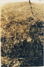
Photograph, C 1920s
... This is a photo of the Mt. Victory Road under construction... 117-119 Grampians Road Halls Gap grampians This is a photo ...This is a photo of the Mt. Victory Road under construction. The workers camp can be seen in front of the road. For further information see 'Victoria's Wonderland', pp 102, 112 & 136. Note: The second copy is a transparency held at Slide Box No. 162.The photo shows a slope covered in thick bush. A road can just be seen in the middle foreground and a campsite with many tents can be seen through the bush in front of the road.access routes, mt victory rd -
 Melbourne Tram Museum
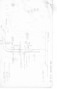
Document - Research Notes, H. S. McComb, development and timing of the "PMTT" - part 2, 1950's
... Road, Victoria St cable tram terminus, Kew Depot, Candy Corner... Road, Victoria St cable tram terminus, Kew Depot, Candy Corner ...Set of papers, handwritten concerning the development and timing of the "PMTT", Prahran and Malvern - about 40 sheets. Prepared by H. S. McComb - gives layout of the PMTT system, primarily of Burke Road, sketches of track layout, opening dates, sketches of various junctions, bridges, track miles, junctions, reconciliation of track lengths from various sources includes Whitehorse Road, Victoria St cable tram terminus, Kew Depot, Candy Corner, St Kilda terminus, Malvern Depot, High St, Items 2041 to 2052 within box 72.3 in a brown folder marked "PMTT" in red pencil.trams, tramways, pmtt, malvern, routes, track, kew depot, burke rd, surveys, victoria st, whitehorse rd, malvern depot, st kilda, candy corner -
 Ballarat Tramway Museum
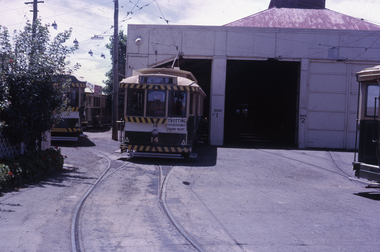
Slide - 35mm slide/s, Peter Moses, Jan. 1966
... with tram No. 14 on No. 1 road, with destination of "Victoria St... tram depot front with tram No. 14 on No. 1 road ...Photo of Ballarat SEC Wendouree Parade tram depot front with tram No. 14 on No. 1 road, with destination of "Victoria St." and "Trotting Showgrounds Friday Night" auxiliary board on the front of the tram. Note the tram fitted with the white stripe under the dash canopy lights and the use of the large and small numbers of the tram. Kodak cardboard mount slide, taken by Peter Moses January 1966.On back of slide in blue ink "Jan. 1966 / Tram Depot Ballarat No. 14" and bottom right hand corner "P. Moses".tramways, trams, sec depot, tram numbering, depot, wendouree parade, tram 14 -
 Lakes Entrance Historical Society
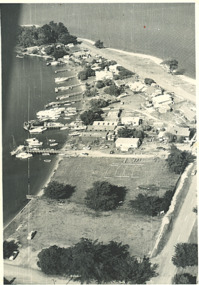
Photograph, Shaving Point Metung Victoria, 1960
... , and beach on Lake King side with road to Shaving Point Metung... side, and beach on Lake King side with road to Shaving Point ...Black and white aerial photograph of village of Metung showing hotel and main wharf and private jetties on Bay side, and beach on Lake King side with road to Shaving Point Metung Victoria. Also a black and white photograph of Village Store Metung Victoria 1930 cwaterways -
 Marysville & District Historical Society
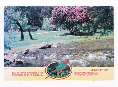
Postcard (item) - Colour postcard, Neil Cutts, Marysville Victoria-Steavenson River, Pre 2009
... No./ 3527 ADDRESS/ Nancy Oliver/ 14/150 Tyabb Road/ Mornington... Oliver/ 14/150 Tyabb Road/ Mornington/ Victoria - 3931/ POSTCODE ...A postcard in a series produced by the Rose Stereograph Company in Victoria, Australia as a souvenir of Marysville.A colour photograph of the Steavenson River which flows through Marysville in Victoria. The Rose Series postcard No. 3527.POST CARD The "Rose" Series/ De Luxe Proudly Printed in/ Australia Since 1880 AFFIX/ STAMP/ HERE/ Rose Series/ Post Card No./ 3527 ADDRESS/ Nancy Oliver/ 14/150 Tyabb Road/ Mornington/ Victoria - 3931/ POSTCODE Steavenson River/ MARYSVILLE, VICTORIA, AUSTRALIA/ Photo Neil Cutts Copyright Rose Stereograph Co., Glen Waverley, Victoria (03) 9560 7772 8-3-2003 Dear Nancy/ here we are/ at Mary Lyn./ Everything is about the name nice/ pleasant & cheerful & restful meeting different people/ every day but we miss dear Nancy & Company eh?/ We did not notice any changes the prices are up./ We enjoy walking most mornings Eric enjoys/ longer walks in the afternoon. The weather so far/ has been nice cool and/ pleasant and time is passing/ quickly Hope to meet you in/ Nov. all being well./ Love Sarina & Ericmarysville, victoria, steavenson river, postcard, souvenir, rose stereograph co, 3527 -
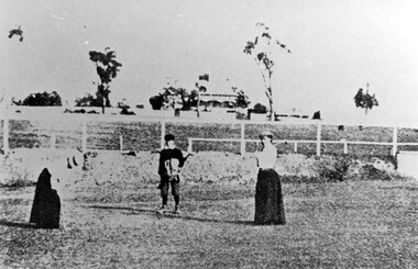 Surrey Hills Historical Society Collection
Photograph, Surrey Hills Golf Club eighth hole, 1902, 1902
... Road and down Victoria Crescent to where Box Hill TAFE is now... Trafalgar Street, Mont Albert to Whitehorse Road and down Victoria ...Reproduced by permission of Mr John Arnold from his book: "The Riversdale Golf Club - a history, 1892-1977." Copyright to book: Riversdale Golf Club. Surrey Hills Golf Club operated from 1892-1908 then moved and became Riversdale Golf Club. The game was played across paddocks from Trafalgar Street, Mont Albert to Whitehorse Road and down Victoria Crescent to where Box Hill TAFE is now located in Elgar Road. There were problems with cows eating the tee flags! The clubhouse still exists as 30 Trafalgar Street. No 3 Beatty Street is in the background. The players are probably standing on what is now Zetland Road.This image is important not only for documentation of early sporting activities in the area but also for evidence of the pre-urban appearance of the landscape.Black and white photo with 2 ladies with golf clubs in the foreground and a lad (? caddy) with a golf bag under his arm. He is wearing a cap and 'plus fours'. The ladies are wearing long skirts, blouses and hats. Behind is a post-and-rail fence with a house and trees in the background.Caption: " Bottom: Putting out on the eighth hole, 1902."sports grounds, surrey hills golf club, riversdale golf club, clothing and dress, zetland road, surrey hills, john arnold -
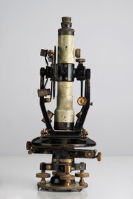 City of Greater Bendigo - Civic Collection
Instrument - Theodolite, E. R. Watts & Sons, c 1930
... on the back of Road Users' Association of Victoria letterhead note... adjustments to the Theodolite written on the back of Road Users ...Theodolites are a highly accurate instrument that measures angles between designated visible points in the horizontal and vertical planes. The theodolite has a long history, with the term first found in 1571 in a surveying textbook 'A geometric practice named Pantometria' by Leonard Digges. (source https://en.wikipedia.org/wiki/Theodolite). Theodolites are used by surveyors as part of their everyday work and although there is no specific information regarding the provenance of this particular one it is assumed it was used locally by the Shire of Marong and / or the Lands Department. Edwin Watts started the company in 1856, trading up to 1920s as E.R. Watts & Son with E. R. Watts & Son Ltd amalgamating with Adam Hilger Ltd to form Hilger & Watts in 1948.0442.1 A black and grey theodolite no 39161 made by Watts & Sons. Various moving parts showing signs of extensive use particularly on the uprights on the main body and around knobs and dials where the paint is worn back to brass. Is housed in original box with key, oil container and pin. 0442.2 handwritten instructions for making adjustments to the Theodolite written on the back of Road Users' Association of Victoria letterhead note paper.Watts & Sons / London / 5974 For N H Seward / Melbournelands and survey department bendigo, shire of marong -
![Public Works Street Maintenance, Gellibrand Street [Kew]](/media/collectors/550653872162f11fb04854aa/items/58ce1cc9d0cde409d84fcde4/item-media/58cf6195d0cedc331404a41c/item-fit-380x285.jpg) Kew Historical Society Inc
Kew Historical Society IncPhotograph - Public Works Street Maintenance, Gellibrand Street, 1970
... / Company / 1st Floor 66-68 Albert Road/ South Melbourne 3205... Road/ South Melbourne 3205 Victoria / Telephone 699 1455 / 699 ...Public Works Street Maintenance, Gellibrand Street, Kew, Company supplied photograph of root clearance from drains. Inscribed above photo: "Cable winch setup with 'snatch block' in manhole. Sample of roots removed on spoil. Gellibrand St. 24.4.70." Company information: "General Descaling / Company / 1st Floor 66-68 Albert Road/ South Melbourne 3205 Victoria / Telephone 699 1455 / 699 1635."general descaling, drains, gellibrand street (kew) -
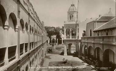 Melbourne Legacy
Postcard, Orange Hotel Oostkant, Soerabaia, Java, c1915
... . W. Elsum. 30 Station Road. North Williamstown. Victoria.... 30 Station Road. North Williamstown. Victoria. Australia ...This postcard has a photo of the Orange Hotel Oostkant, Soerabaia, Java taken around 1915 (now known as Surabaya in Indonesia). Perhaps the sender, Lee, was a returning serviceman from World War One coming back to Australia via Indonesia and this was a card home to his family.A record of postal correspondence in 1915. Postcards were a very common form of communication in the first World War. This type of souvenir would have been familiar to the first Legatees as they had served in World War 1.Glossy postcard with photo of the Orange Hotel in Java.Handwritten: "Dear Katy, Am going to spend a week or so in Java. Hope you are all well. I am feeling very fit, Lee. / Mrs. W. Elsum. 30 Station Road. North Williamstown. Victoria. Australia. " Printed on the photo - 2 / Orange Hotel Oostkant, Soerabaia, Java. / Photo. KURKDJIAN LTD, SOERABAIA.Printed on card - POST CARD / The Address only to be written here Stamp - Nederlandsch-Indie, 5 CENT Postmark - SOERABAJA 16.7.15 souvenir, war correspondence -
 Bendigo Historical Society Inc.
Photograph - EPSOM PRIMARY SCHOOL PHOTOGRAPH
... from 'Kernan Group' 403-405 Mount Alexander Road, Ascot Vale... Alexander Road, Ascot Vale, Victoria 3032. Covering letter dated ...Caption of photograph reads 'Taken at the Epsom School in 1913.' Reverse ditto but includes 20th Dec 1913. Jess 6, Rene 8 1/2 , Dorrie 13 1/2. Mrs J Kane c/o Mrs I Rowe Epsom. Enclosed in envelope addressed to Trevor Parsons postal dated 2010 from 'Kernan Group' 403-405 Mount Alexander Road, Ascot Vale, Victoria 3032. Covering letter dated 19th February 2010 enclosed from Damien Jenkyn to Kerry Mc Guffe principal of Epsom Primary School relating to 'Shelter Shed' pictured in photograph. Photo taken by W.H. Robinsonbendigo, education, epsom primary school -
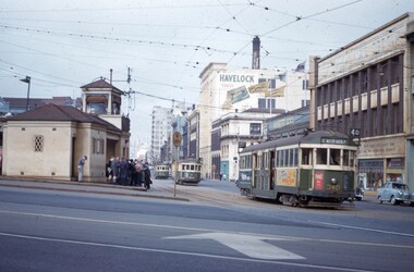 Melbourne Tram Museum
Slide - Set of 2, John Webster, 21/07/1959 12:00:00 AM
... , Toorak - Glenferrie Road) in the Victoria St shunting area. Has...Melbourne Tram Museum 8 Wallen Road Hawthorn melbourne ...Set of two Colour slides, Kodak, white cardboard of trams of trams at the Victoria St / Swanston St shunt. 21-7-59. .1 - W2 340 showing East Malvern Darling road opposite the signal box followed by W2 showing route 4. Has a large number of men and school boys at the stop. In the view is a "No Entry" sign. In the background is the Ansett ANA building and a building advertising Havelock Tobacco. The tram has a Pimms No. 1 advert. .2 - W2's 550 (with a Castrol sign), 340 - as above and 358 (route 8, Toorak - Glenferrie Road) in the Victoria St shunting area. Has the Army hall behind the trams.Hand writing on rear in ink; "21-7-59 - KFB2 - TRACK - KEV - Swanston St near Victoria St Melbourne" "21-7-59 - KFB3 - TRACK - KEV - Trams in Victoria St Melbourne" Both slides have the speed and the f reading on the left hand side.trams, tramways, victoria st, swanston st, signal box, route 4, route 8, route 4d, east malvern, tram 550, tram 358, tram 340 -
 Eltham District Historical Society Inc
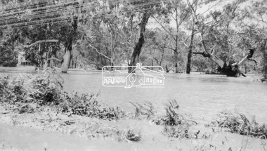
Photograph, Floodwaters, Diamond Creek, Eltham, 1934
... The Diamond Creek in flood near the Main Road bridge... melbourne The Diamond Creek in flood near the Main Road bridge ...The Diamond Creek in flood near the Main Road bridge at Eltham, Victoria. The Yarra also was in flood. In early December 1934 the "Greatest flood in the history of the Yarra" occured, according to The Argus newspaper. Bridges and houses were swept away with hundreds of people left homeless across the state. The historic 1934 flood of the Diamond Creek and Yarra River set the criteria for future planning with respect to flood water rise.This photo forms part of a collection of photographs gathered by the Shire of Eltham for their centenary project book, "Pioneers and Painters: 100 years of the Shire of Eltham" by Alan Marshall (1971). The collection of over 500 images is held in partnership between Eltham District Historical Society and Yarra Plenty Regional Library (Eltham Library) and is now formally known as 'The Shire of Eltham Pioneers Photograph Collection.' It is significant in being the first community sourced collection representing the places and people of the Shire's first one hundred years.Digital image 4 x 5 inch B&W Neg (2 frames on one neg) 9 x 15.5 cm B&W printflooding, eltham, shire of eltham pioneers photograph collection, sepp, diamond creek (river), floods, 1934 flood, diamond creek -
 Surrey Hills Historical Society Collection
Photograph, Streetscape near the corner of Victoria Crescent and Hotham Street, Surrey Hills
... from Trafalgar Street, Mont Albert to Whitehorse Road and down... Road and down Victoria Crescent to where Box Hill TAFE is now ...Prior to subdivision for housing this area was paddocks used for grazing of cattle and used as part of the course in the early days of the Surrey Hills Golf Club. Reproduced by permission of Mr John Arnold from his book: "The Riversdale Golf Club - a history, 1892-1977." Copyright to book: Riversdale Golf Club. Surrey Hills Golf Club operated from 1892-1908 then moved and became Riversdale Golf Club. The game was played across paddocks from Trafalgar Street, Mont Albert to Whitehorse Road and down Victoria Crescent to where Box Hill TAFE is now located in Elgar Road. There were problems with cows eating the tee flags! The clubhouse still exists as 30 Trafalgar Street.Black and white photo taken from the centre of a bitumen road which is flanked by bluestone guttering. Nature strips, drive cross-overs and house fences are shown. Trees on the RHS nature strip are pollarded to avoid overhead power and telephone lines. There houses in the background."Bottom: The same view today taken from the intersection of Victoria Crescent and Hotham Street, Surrey Hills."surrey hills golf club, hotham street, victoria crescent, riversdale golf club, surrey hills, john arnold -
 Marysville & District Historical Society
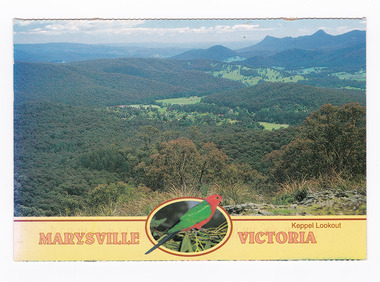
Postcard (item) - Colour postcard, Neil Cutts, Marysville Victoria-Keppel Lookout, Pre 2009
... No./ 3526 ADDRESS/ Nancy Oliver/ 14/150 Tyabb Road/ Mornington... in a series produced by the Rose Stereograph Company in Victoria ...A postcard in a series produced by the Rose Stereograph Company in Victoria, Australia as a souvenir of Marysville.A colour photograph of the view of Marysville in Victoria from Keppel Lookout. Keppel Lookout is named after the Keppel Family who were one of Marysville's earliest pioneering families. The Rose Series postcard No. 3526.POST CARD The "Rose" Series/ De Luxe Proudly Printed in/ Australia Since 1880 AFFIX/ STAMP/ HERE/ Rose Series/ Post Card No./ 3526 ADDRESS/ Nancy Oliver/ 14/150 Tyabb Road/ Mornington/ Victoria 3931/ POSTCODE Keppel Lookout/ MARYSVILLE, VICTORIA, AUSTRALIA/ Photo Neil Cutts Copyright Rose Stereograph Co., Glen Waverley, Victoria (03) 9560 7772 MaryLyn - Marysville/ 10.03.2002 Dear Nancy/ First I want to/ thank you for nice cards/ get well, and others very/ much indeed. We miss/ you not coming here but I hope/ you enjoyed where you went/ Nancy as usual Mary Lyn/ is a nice place to enjoy and/ to feel relaxed and friendly/ in every way. Weather has been/ cool and pleasant with some/ few hot days to enjoy and to/ remind us of summer - not/ many here at/ present more coming./ Our love to/ all we know/ and love to your/ dear self hope/ to see you next/ time Sarina & Eric marysville, victoria, keppel lookout, postcard, souvenir, rose stereograph co, 3526 -
 Ringwood and District Historical Society
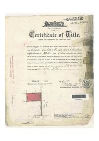
Document, Certificate of Title - Thomas Arthur Wentworth Burkitt - part of Crown Section 20, Parish of Warrandyte, County of Evelyn - 1st April, 1919
... , being part of Lot 9 on plan of subdivision no.4315, Bemboka Road..., being part of Lot 9 on plan of subdivision no.4315, Bemboka Road ...A4 copies of Landata Victoria Historical Search documents - Vol 4197 Fol 839286.Winifred Cambridge of Balwyn, Married Woman, is now the proprietor of an Estate in Fee-simple subject to the Encumbrances notified hereunder ... 17 acres 2 roods 3 perches or thereabouts, being part of Lot 9 on plan of subdivision no.4315, Bemboka Road, Warranwood, Victoria. Encumbrance comment "Appurtenant to carriageway over Omeo Parade on LP12040". Transfers include John Collins of Brysons Road Ringwood, Farmer - 16th June, 1944, Kevin Collins of Warranwood, Carrier - 20th September, 1951, Francis Mohan of St.Kilda - 19th January, 1968, Vivian Campbell Rush, Engineer, and Dorothy May Rush, Married Woman, both of Main Road, Warrandyte, joint proprietors, and Alan Humphrey Croxford, Gentleman, and Eleanor Pearl Croxford, Married Woman, both of Pound Road, Warrandyte, joint proprietors as Tenants In Common - 31st March, 1969, Transferred as to the interest of Alan Humphrey Croxford and Eleanor Pearl Croxford - 13th July, 1973. (See Alan Humphrey Croxford biography link https://adb.anu.edu.au/biography/croxford-alan-humphrey-12375) -
 Orbost & District Historical Society
book, Broadbent's Melbourne - Sydney Guide Book, 1936
... an active vice-president of the Good Roads Association of Victoria... gippsland Broadbent's Official Road Guides Company took over George ...Broadbent's Official Road Guides Company took over George R. Broadbent's business in 1935. In 1963, it changed its name to Broadbent's Road Maps Pty. Ltd. George Robert Broadbent (1863-1947), cyclist and map publisher, was born on 3 November 1863 at Ashby near Geelong, Victoria. At various times Broadbent held most Victorian and Australian road cycling records. Broadbent became an active vice-president of the Good Roads Association of Victoria in November 1912 and was consulted regularly during the preparation of the country roads bill. That year he took over the Argus motoring column, wrote tirelessly on road improvements and maintenance, and became manager of the Automobile Club's new touring department in 1914.A 160 pp road guide book titled Broadbent's Official Road Guide Melbourne - Sydney. The front cover has a yellow background with a map of the coastline from Sydney to Melbourne, the Prince's Highway route marked. This is inset in a drawing of a car driving along the coastal road.The book contains speedometer readings, route maps, advertisements and photos of points of interest. In the top right is the logo of the Royal Automobile Club of Victoria and at the bottom right is the price 1/-.traavel road-guides broadbent-george car-touring -
 Wodonga & District Historical Society Inc
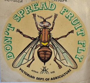
Document - Fruit Fly Border Express Pass, De Neefe Signs Pty. Ltd, c1960
... The permanent fruit fly road blocks in Victoria began... The permanent fruit fly road blocks in Victoria began in 1958. The first ...The permanent fruit fly road blocks in Victoria began in 1958. The first was set up on the Lincoln Causeway between Albury and Wodonga. The aim was to protect the Victorian fruit export industry, the largest in the country. Cars would be stopped and inspected when entering Victoria. At peaks periods, such as Easter and school holidays, there were up to 10 inspectors at the 24 hour checkpoint near the former butter factory on the Lincoln Causeway. Local residents could apply for a pass such as this one which would be displayed on their window, but were still subject to random checks. Hundreds of tonnes of fruit each week was confiscated and pulverised by Department of Agriculture staff. The road block was closed in 1980, partly due to the increased traffic flows and the cost of maintaining inspection points.This image reflects government measures taken to protect the fruit industry in Victoria.A transparent sticker designed to be applied to a car window for motorists to pass through Department of Agriculture fruit fly control points. Instructions for applying the sticker to the window are written on the back of the sticker. It features a large coloured image of a fruit fly as well as a smaller life sized representation of a fruit fly.Around the edge of the circle: "DON'T SPREAD FRUIT FLY/ VICTORIAN DEPT. OF AGRICULTURE? Beside small fruit fly image: "Actual Size"fruit fly control, department of agriculture, fruit fly pass -
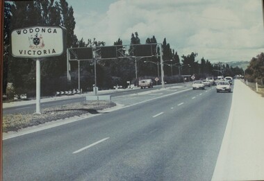 Wodonga & District Historical Society Inc
Photograph - Wodonga, Victoria sign and the Fruit Fly check point c1970s
... The permanent fruit fly road blocks in Victoria began... The permanent fruit fly road blocks in Victoria began in 1958. The first ...The permanent fruit fly road blocks in Victoria began in 1958. The first was set up on the Lincoln Causeway between Albury and Wodonga. The aim was to protect the Victorian fruit export industry, the largest in the country. Cars would be stopped and inspected when entering Victoria. At peaks periods, such as Easter and school holidays, there were up to 10 inspectors at the 24 hour checkpoint near the former butter factory on the Lincoln Causeway. Local residents could apply for a pass which would be displayed on their window, but were still subject to random checks. Hundreds of tonnes of fruit each week was confiscated and pulverised by Department of Agriculture staff. The road block was closed in 1980, partly due to the increased traffic flows and the cost of maintaining inspection points.This image reflects government measures taken to protect the fruit industry in Victoria.A large image of the LIncoln Causeway at the Victorian/NSW border at Wodonga. The southbound lanes on the right hand side feature overhead signals and traffic light signs to control traffic leading into the Fruit fly inspection checkpoint ahead. The photo is in a wooden frame.On right hand side: Border sign: Wodonga/Victoria and the Victorian State Coat of Arms.fruit fly control, victoria border, lincoln causeway wodonga -
 Vision Australia
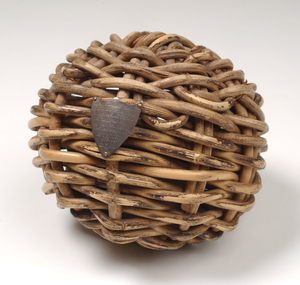
Award - Object, Wicker cricket ball, 1928
... and clubhouse in Glenferrie Road Kooyong, Victoria on behalf... and developing the sports ground and clubhouse in Glenferrie Road Kooyong ...This cricket ball is made of cane wicker and was used in cricket games with visually impaired players by people who lived or were educated at the Royal Victorian Institute for the Blind from the 1920's through till 1972. It is a circular shape made of plaited strips of woven natural cane and is lighter than a conventional cricket ball. The hollow center of the ball contains pieces of twisted metal pieces which rattle as the ball is moved to aid players in tracking the ball's movement. The stumps also had bells attached so fielders knew when the batsman was out. Blind cricket was invented in Melbourne in 1922 when two blind factory workers started playing a game using a tin can containing rocks. The game soon gained popularity and the Victorian Blind Cricketers' Association was formed. Mr William Paterson, a volunteer worker and advocate for blind people for over 60 years, was instrumental in acquiring and developing the sports ground and clubhouse in Glenferrie Road Kooyong, Victoria on behalf of the Association for the Advancement of the Blind (now called Vision Australia). In 1928 play began on the world's first sports ground for blind cricketers, in the first official blind cricket match. Blind cricket is now played internationally. This particular cricket ball was awarded to William Paterson Esq in 1928 in recognition of his support in establishing the world's first blind cricket ground in Kooyong. On the front of this ball is attached a small metal crest with an inscription: 'Presented to W.H. Paterson, Esq as a token of esteem for his interest in Blind cricket being the first ball bowled on the cricket ground for Blind Kooyong 7. 4.28'.1 wicker cricket ball with metal shield attached and metal bells in the hollow centre'Presented to W.H. Paterson, Esq / as a token of esteem for his/ interest in Blind cricket/ being the first ball bowled /on the cricket /ground for Blind /Kooyong / 7. 4.28'. recreation equipment, awards -
 Eltham District Historical Society Inc
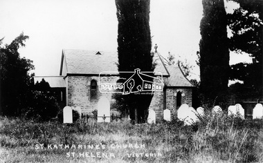
Photograph, St. Katherine's Church, St. Helena, Vic
... Located at 277-279 St Helena Road Saint Helena, Victoria... melbourne Located at 277-279 St Helena Road Saint Helena, Victoria ...Located at 277-279 St Helena Road Saint Helena, Victoria. In 1841 Anthony Beale, born on the Island if St Helena took a pastoral lease on the Plenty River where he built a cottage, St Helena, which ultimately gave this area its name. Beale's wife Katherine Rose, nee Young died in 1856 and he erected "The rose Chapel" to her memory. After his death in 1865 the chapel was willed to the Church of England and consecrated in 1876. It was severely damaged by bushfire in 1957. It was fully restored and rededicated in November 1957. The bell calls parishoners to Sunday services is believed to a have come from the Island of St Helena. Source: Mr. A.E. Parsons, Pryor St., Eltham (Mrs. Glasgow - daughter)Statement of Significance Last updated on - October 10, 2005 St Helena's is a rare surviving example of a churchyard cemetery. It is of local historical significance because of its association with the local pioneering family, the Beales, and other notable citizens including Walter Withers and Graham Webster. The cemetery is also the oldest in the municipality, of State significance. The high level of maintenance and the rural ambience contribute to the overall significance of the site. St Katherine's Church building has been reconstructed and is of local historical interest, principally for its value in interpreting the original setting within the Cemetery. It contains stained glass windows of local historical significance, commemorating casualties of the Beale family in World War One. - Victorian Heritage Database This photo forms part of a collection of photographs gathered by the Shire of Eltham for their centenary project book,"Pioneers and Painters: 100 years of the Shire of Eltham" by Alan Marshall (1971). The collection of over 500 images is held in partnership between Eltham District Historical Society and Yarra Plenty Regional Library (Eltham Library) and is now formally known as the 'The Shire of Eltham Pioneers Photograph Collection.' It is significant in being the first community sourced collection representing the places and people of the Shire's first one hundred years.Digital image"St Katharine's Church, St Helena, Victoria"sepp, shire of eltham pioneers photograph collection, other areas, st katherine's church, st helena -
 Eltham District Historical Society Inc
Negative - Photograph, Floodwaters, Diamond Creek, Eltham, 1934
... The Diamond Creek in flood near the Main Road bridge... melbourne The Diamond Creek in flood near the Main Road bridge ...The Diamond Creek in flood near the Main Road bridge at Eltham, Victoria. The Yarra also was in flood. In early December 1934 the "Greatest flood in the history of the Yarra" occured, according to The Argus newspaper. Bridges and houses were swept away with hundreds of people left homeless across the state. The historic 1934 flood of the Diamond Creek and Yarra River set the criteria for future planning with respect to flood water rise. Noted on reverse of print - Copied by Hugh Fisher, 82 Lygon St., BrunswickThis photo forms part of a collection of photographs gathered by the Shire of Eltham for their centenary project book,"Pioneers and Painters: 100 years of the Shire of Eltham" by Alan Marshall (1971). The collection of over 500 images is held in partnership between Eltham District Historical Society and Yarra Plenty Regional Library (Eltham Library) and is now formally known as the 'The Shire of Eltham Pioneers Photograph Collection.' It is significant in being the first community sourced collection representing the places and people of the Shire's first one hundred years.Digital image 4 x 5 inch B&W Neg (2 frames on one neg) Print 9 x 15.5 cmOn reverse of print - "Copied by Hugh Fisher, 82 Lygon St., Brunswick" (for Shire of Eltham)sepp, shire of eltham pioneers photograph collection, eltham, floods, 1934 flood, diamond creek (creek), floodwater -
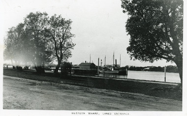 Lakes Entrance Historical Society
Photograph - Western Wharf, 1910c
... small tree inside tree guard. Unsealed road in foreground. Lakes... small tree inside tree guard. Unsealed road in foreground. Lakes ...Black and white photograph of the Western Wharf, colloquially known as the Post Office Jetty. It shows a steamer moored at the wharf beside a sail powered vessel. There is a shed at the end of the jetty, another near the shore. Some banksia trees on bank, also small tree inside tree guard. Unsealed road in foreground. Lakes Entrance VictoriaWestern Wharf Lakes Entrancejetties, township, ships and shipping -
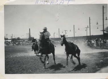 Ballarat Heritage Services
b & w photograph, Ballarat Rodeo, 1962
... and some friends were on a road trip across Victoria to New South...). She and some friends were on a road trip across Victoria ...Letter sent with two photographs. Please find enclosed a couple of photos taken in Ballarat in 1962 which came from an album of my mother's Marian Mitchell (nee Robinson). She and some friends were on a road trip across Victoria to New South Wales. You are welcome to reprint these. One is of the Ballarat Rodeo and the other is of mum in the morning at their roadside camp in Ballarat. The sign on the shed has two words, the first one says Caledonia - the second perhaps you'll be able to find out? Both taken in 1962. I hereby give you permission for your society to re-print and distribute both these photos as you choose (although these aren't exactly the most expertly taken pictures). If more come our way over the course of my continued cleaning out of the cupboards I will send these too. Cheers etc3.5" x 5" landscape size black and white photograph showing horses and riders in a rodeo at Ballarat Showgrounds.BALLARAT (front top) Verso: Bronco minus cowboy Ballarat Rodeo 1962 -
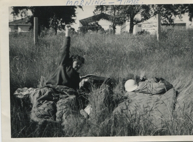 Ballarat Heritage Services
b & w photograph, Morning time at Camp site, 1962
... and some friends were on a road trip across Victoria to New South...). She and some friends were on a road trip across Victoria ...Letter sent with two photographs. Please find enclosed a couple of photos taken in Ballarat in 1962 which came from an album of my mother's Marian Mitchell (nee Robinson). She and some friends were on a road trip across Victoria to New South Wales. You are welcome to reprint these. One is of the Ballarat Rodeo and the other is of mum in the morning at their roadside camp in Ballarat. The sign on the shed has two words, the first one says Caledonia - the second perhaps you'll be able to find out? Both taken in 1962. I hereby give you permission for your society to re-print and distribute both these photos as you choose (although these aren't exactly the most expertly taken pictures). If more come our way over the course of my continued cleaning out of the cupboards I will send these too. Cheers etc3.5" x 5" landscape size black and white photographMORNING - TIME (top front) Verso: Me at Ballarat (trying not to laugh) Marian Robinson -1962- -
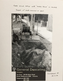 Kew Historical Society Inc
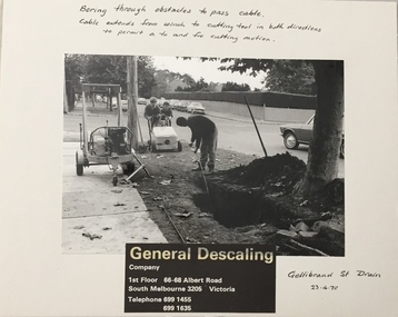
Photograph - Public Works Street Maintenance, Gellibrand Street, General Descaling, 1970
... / Company / 1st Floor 66-68 Albert Road/ South Melbourne 3205... Road/ South Melbourne 3205 Victoria / Telephone 699 1455 / 699 ...The series from which the photograph is drawn provides a snapshot by a commercial photographic studio of specific street works in Kew as well as providing examples of public works infrastructure being commissioned by local government in the 1970s. The photos originally formed part of the Engineering Department's files in the City of Kew before being donated to the Kew Historical Society.In addition to its historic importance as a record of a particular streetscape in Kew in 1970, the photograph also provides an historic record of public works by local government during the period.Public Works Street Maintenance, Gellibrand Street, Kew, Company supplied photograph of cable laying in Gellibrand Street. Inscribed above photo: "Boring through obstacles to pass cable. Cable extends from winch to cutting tool in both directions to permit a to and fro cutting motion. Gellibrand St. Drain 23.4.70." Company information: "General Descaling / Company / 1st Floor 66-68 Albert Road/ South Melbourne 3205 Victoria / Telephone 699 1455 / 699 1635."general descaling, drains, gellibrand street (kew) -
 Kew Historical Society Inc
Photograph - Public Works Street Maintenance, Gellibrand Street, General Descaling, 1970
... / Company / 1st Floor 66-68 Albert Road/ South Melbourne 3205... Road/ South Melbourne 3205 Victoria / Telephone 699 1455 / 699 ...The series from which the photograph is drawn provides a snapshot by a commercial photographic studio of specific street works in Kew as well as providing examples of public works infrastructure being commissioned by local government in the 1970s. The photos originally formed part of the Engineering Department's files in the City of Kew before being donated to the Kew Historical Society.In addition to its historic importance as a record of a particular streetscape in Kew in 1970, the photograph also provides an historic record of public works by local government during the period.Public Works Street Maintenance, Gellibrand Street, Kew. Company supplied photograph of cable laying in Gellibrand Street. Inscribed above photo: "Boring through obstacles to pass cable. Cable extends from winch to cutting tool in both directions to permit a to and fro cutting motion. Gellibrand St. Drain 23.4.70." Company information: "General Descaling / Company / 1st Floor 66-68 Albert Road/ South Melbourne 3205 Victoria / Telephone 699 1455 / 699 1635."general descaling, drains, gellibrand street (kew)