Showing 285062 items matching "streets,roads,melbourne,map,melway"
-
 Melbourne Tram Museum
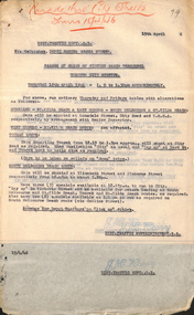
Document - Memorandum, Melbourne & Metropolitan Tramways Board (MMTB), Parade of units of victory march personnel through city streets, 8/02/1946 12:00:00 AM
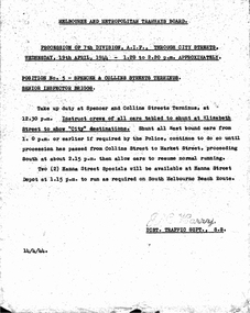
... streets ...Parade of units of victory march personnel through city streets Thursday 18 April 1946 - 1:00PM to 1:30PM 18 memos from JM Harry, Dist Traffic Supt SS regarding bus & tram arrangements to various inspectors. Memos dated 13, 15 April 1946.Notations written in pencil on several memos.trams, tramways, events, parades, hanna st depot, malvern depot, glenhuntly tram depot, hawthorn depot, camberwell depot, port melbourne depot, central bus garage -
 Kew Historical Society Inc
Plan, Melbourne & Metropolitan Board of Works : Borough of Kew : Detail Plan No.1585, 1904
The Melbourne and Metropolitan Board of Works (MMBW) plans were produced from the 1890s to the 1950s. They were crucial to the design and development of Melbourne's sewerage and drainage system. The plans, at a scale of 40 feet to 1 inch (1:480), provide a detailed historical record of Melbourne streetscapes and environmental features. Each plan covers one or two street blocks (roughly six streets), showing details of buildings, including garden layouts and ownership boundaries, and features such as laneways, drains, bridges, parks, municipal boundaries and other prominent landmarks as they existed at the time each plan was produced. (Source: State Library of Victoria)This plan forms part of a large group of MMBW plans and maps that was donated to the Society by the Mr Poulter, City Engineer of the City of Kew in 1989. Within this collection, thirty-five hand-coloured plans, backed with linen, are of statewide significance as they include annotations that provide details of construction materials used in buildings in the first decade of the 20th century as well as additional information about land ownership and usage. The copies in the Public Record Office Victoria and the State Library of Victoria are monochrome versions which do not denote building materials so that the maps in this collection are invaluable and unique tools for researchers and heritage consultants. A number of the plans are not held in the collection of the State Library of Victoria so they have the additional attribute of rarity.Original survey plan, issued by the MMBW to a contractor with responsibility for constructing sewers in the area identified on the plan within the Borough of Kew. The plan was at some stage hand-coloured, possibly by the contractor, but more likely by officers working in the Engineering Department of the Borough and later Town, then City of Kew. The hand-coloured sections of buildings on the plan were used to denote masonry or brick constructions (pink), weatherboard constructions (yellow), and public buildings (grey). This plan, which covers parts of High Street, Pakington Street and Derby Street is dominated by two historic Kew mansions: ‘Konetta’ and ‘Ramornie’. Ramornie was constructed in 1890 for James Maitland Campbell, three times Mayor of Kew. Sold in 1940, it became a boarding house known as ‘The Towers’. Now a private residence again, it has only one of its three balconies remaining. The location of the missing two balconies can be seen on the plan. In 1903, the grounds of Ramornie included a large tennis court fronting Pakington Street. The rear of the property is shown as extending to Cobden Street. One of Kew’s oldest hotels, the Prospect Hill Hotel on the corner of High and Cobden Street was established in 1858. The outline of the hotel shown on the plan represents the second building on the site. During the 19th century it was often used for electoral meetings. The Prospect Hill Hotel was to be redeveloped again in 1928, by the local architect Robert McIntyre. Since the 1980s, the hotel has been a live music venue, the home of the Melbourne Jazz Club, a restaurant and a liquor outlet.melbourne and metropolitan board of works, detail plans, maps - borough of kew, mmbw 1585, cartography -
 Melbourne Tram Museum
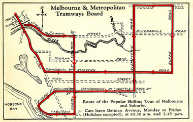
Drawing - Digital Image, Shilling Tour Map, 1927
Map shows the route of the Shilling Tour Map, using Y469 - shows the direction of travel and departure times from Batman Ave. Destination City 5th Edition notes that the services with the tram commenced in June 1927.Yields information about the MMTB's 1927 Shilling tour of Melbourne.Digital Image of an MMTB Map.trams, tramways, y class, tours, tourist trams, tourist trips, tram 191 -
 Kew Historical Society Inc
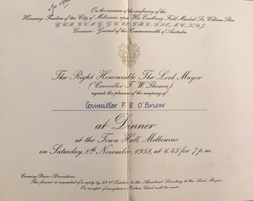
Document (item) - Invitation, City of Melbourne, Dinner on the Occasion of Conferring of Honorary Freedom of the City of Melbourne Upon His Excellency Field Marshall Sir William Slim, 1958
The Municipality of Kew (1860-1863), the Borough of Kew (1863-1910), the Town of Kew (1910-1921) and the City of Kew (1921-1994) were local government instrumentalities in the State of Victoria. In 1994, the City of Kew was amalgamated, together with the former Cities of Camberwell and Hawthorn, into the new City of Boroondara (1994- ). Like other local government entities of the period, Kew was administered by town clerks. The two notable town clerks in Kew's history were H. H. (Henry Hirst) Harrison (1868-1955) and W. D. (William Dickie) Birrell (1899-1974). Harrison was appointed to the position in 1901 and retired in 1938 after 37 years. Birrell, appointed Acting Town Clerk in 1921, became Town Clerk in 1938, following Harrison's retirement. He continued in this role until his retirement in 1966.This card is part of an historically significant civic collection, containing hundreds of separate invitations, documents, greeting cards, programmes and tickets issued and/or collected by successive town clerks. Items in the collection illuminate the political, social and cultural history of the district. As a continuous record, ranging across most decades of the Twentieth Century, they reveal changing tastes in design, values and relationships in the history of local government in Victoria.ON THE OCCASION OF THE CONFERRING OF THE / FREEDOM OF THE CITY OF MELBOURNE UPON HIS EXCELLENCY FIELD MARSHALL SIR WILLIAM SLIM / GCB, GCMG, GCVC, GBE, DSO, MC, KStJ, / GOVERNOR GENERAL OF THE COMMONWEALTH OF AUSTRALIA / THE RIGHT HONOURABLE THE LORD MAYOR / (CR F W THOMAS) / REQUESTS THE PLEASURE OF THE COMPANY OF / Councillor F E O'Brien / AT DINNER / AT THE TOWN HALL, MELBOURNE / ON SATURDAY, 8TH NOVEMBER, 1958, AT 6.45 FOR 7 PM / EVENING DRESS - DECORATIONS / THE FAVOUR IS REQUESTED OF A REPLY BY 23RD OCTOBER, TO THE ASSISTANT SECRETARY TO THE LORD MAYOR / ON RECEIPT OF ACCEPTANCE ENTREE CARD WILL BE SENTcivic invitations -- kew (vic), city of melbourne, field marshall slim.-- governor general of australia -
 Port Melbourne Historical & Preservation Society
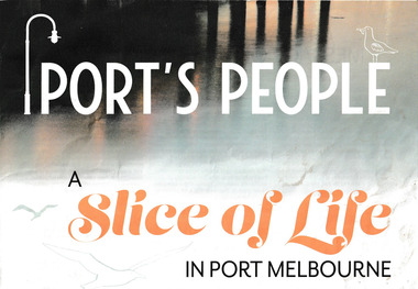
Newsletter, Selina Kayman, Port's People A Slice of Life in Port Melbourne, c. 2020
The newsletter was produced for the Port Melbourne Business Association during a Covid lockdown which featured an article by Port Phillip Mayor, Cr Bernadene VOSS. Two other residents coping with the pandemic are Nick DIMITROKALLIS from the Port Melbourne Bakehouse and Michael McNAMARA, Chief Information Officer for the Federal Government. The back page has a section 'Port Voices' about ideas for Bay Street.A large 4 page coloured newsletter with articles about life in Port Melbourne during Covid.melbourne bakehouse, bernadene voss, nick dimitrokallis, michael mcnamara, port melbourne business association -
 Kew Historical Society Inc
Plan, Melbourne & Metropolitan Board of Works : Borough of Kew : Detail Plan No.1297, 1904
The Melbourne and Metropolitan Board of Works (MMBW) plans were produced from the 1890s to the 1950s. They were crucial to the design and development of Melbourne's sewerage and drainage system. The plans, at a scale of 40 feet to 1 inch (1:480), provide a detailed historical record of Melbourne streetscapes and environmental features. Each plan covers one or two street blocks (roughly six streets), showing details of buildings, including garden layouts and ownership boundaries, and features such as laneways, drains, bridges, parks, municipal boundaries and other prominent landmarks as they existed at the time each plan was produced. (Source: State Library of Victoria)This plan forms part of a large group of MMBW plans and maps that was donated to the Society by the Mr Poulter, City Engineer of the City of Kew in 1989. Within this collection, thirty-five hand-coloured plans, backed with linen, are of statewide significance as they include annotations that provide details of construction materials used in buildings in the first decade of the 20th century as well as additional information about land ownership and usage. The copies in the Public Record Office Victoria and the State Library of Victoria are monochrome versions which do not denote building materials so that the maps in this collection are invaluable and unique tools for researchers and heritage consultants. A number of the plans are not held in the collection of the State Library of Victoria so they have the additional attribute of rarity.Original survey plan, issued by the MMBW to a sewage contractor with responsibility for constructing sewers in the area identified on the plan within the Borough of Kew. The plan was at some stage hand-coloured, possibly by the contractor, but more likely by officers working in the Engineering Department of the Borough and later Town, then City of Kew. The hand-coloured sections of buildings on the plan were used to denote masonry or brick constructions (pink), weatherboard constructions (yellow), and public buildings (grey). This plan of Kew encompasses the area bounded by Barkers Road, High Street and Stevenson Street. Because of the angle created by High Street, a number of houses on the northern side of High Street are shown. The area is dominated by one of the great original landholdings in Kew, described here as the ‘Findon Paddock’. ‘Findon’, the house from which the name of the paddock was taken fronts Stevenson Street and was clearly a rambling structure. The best-known occupant of Findon was Henry ‘Money Miller’ who bought the house in 1871. Miller was a member of Victoria’s first parliament and assisted in the framing of its constitution. Findon was to be subdivided as early as 1912, when the Findon Subdivision was advertised to be sold by auction. In the plan of the subdivision, the original house is not shown, so, presumably it had previously been demolished. Fincham & Son moved the organ, built by Henry Willis, which was installed in the house, first to ‘Whernside’ in Toorak, and later to the Box Hill Methodist Church.melbourne and metropolitan board of works, detail plans, mmbw 1297, cartography, kew (vic.) — municipal collection -
 Melbourne Tram Museum
Map, Morgan Street directory - map of VR Trams, Map - 1940s?
Map - assembled from sheets of the Morgan Street directory for the two VR street tramways from St Kilda to Brighton and from Sandringham Station to Beaumaris or Black Rock. Comprises four sheets taped together and one loose sheet. Tram route marked in green felt pen. Has many adverts on the rear and front for funeral parlours, hotels, real estate agents and the like.trams, tramways, map, vr, sandringham, black rock, beaumaris, brighton, st kilda -
 Kew Historical Society Inc
Book, Gregory's Publishing Company, Gregory's Street Directory: Melbourne, 1988
Street Directory of 1988 with maps of Melbourne and its suburbs.non-fictionstreet directories - melbourne - victoria -
 Kew Historical Society Inc
Plan, J R Mathers & McMillan, Sackville, Thomas & Lytton Streets, Kew, Twentieth Century
... Sackville, Thomas & Lytton Streets, Kew ...The Kew Historical Society's map collection includes a substantial number of real estate subdivision plans, mainly of Kew but also of surrounding suburbs in Melbourne. Most of the subdivision plans date from the 1920s and 1930s when the districts old homes and local farmland were being split up to accommodate residential growth in the postwar period. These early plans were assembled by a local firm, Jas R Mather & McMillan, which had an office in Cotham Road. Many of the plans, and sometimes photos, were annotated by the agents.Subdivision plans are historically important documents used as evidence for the growth of suburbs in Australia. They frequently provide information about when the land was sold as well as evidence relating to surveyors and real estate and financial agents. The numerous subdivision plans in the Kew Historical Society's collection represent working documents, ranging from the initial sketches made in planning a subdivision to printed plans on which auctioneers or agents listed the prices for which individual lots were sold. In a number of cases, the reverse of a subdivision plan in the collection includes a photograph of a house that was also for sale by the agent. These photographs provide significant heritage information relating house design and decoration, fencing and household gardens.The photograph may also be aesthetically significant depending on the importance of the photographic atelier.Lithographed subdivision plan for an un-named estate with 28 allotments facing Lytton, Sackville and Thomas Streets in Kew. The land would have originally formed part of the Dumaresq Estate. subdivision plans - kew, lytton street, sackville street, thomas street - kew -
 Kew Historical Society Inc
Plan, Melbourne & Metropolitan Board of Works : Contour Plan of Melbourne & Suburbs : Melbourne Sewage, 1894
The Melbourne and Metropolitan Board of Works (MMBW) plans were produced from the 1890s to the 1950s. They were crucial to the design and development of Melbourne's sewerage and drainage system. This plan forms part of a large group of MMBW plans and maps that was donated to the Society by the Mr Poulter, City Engineer of the City of Kew in 1989. Within this collection, thirty-five hand-coloured plans, backed with linen, are of statewide significance as they include annotations that provide details of construction materials used in buildings in the first decade of the 20th century as well as additional information about land ownership and usage. The copies in the Public Record Office Victoria and the State Library of Victoria are monochrome versions which do not denote building materials so that the maps in this collection are invaluable and unique tools for researchers and heritage consultants. A number of the plans are not held in the collection of the State Library of Victoria so they have the additional attribute of rarity.Digital copy of an original MMBW plan. This contour plan shows the area identified by the MMBW for purposes of drainage and sewerage in 1894. The suburbs represented extend from Williamstown in the west to Bulleen in the east, and from Preston in the north, south to Sandringham. Suburbs are outlined in coloured ink. Red lines indicate main and branch sewers in existence at the beginning of 1894 in central and inner Melbourne. These extended as far as Williamstown and Brighton, but not yet as far as Kew, where sewering did not commence until 1901. Contour lines show the topography, which was important for indicating the fall of the land for the laying of sewers and drainage channels. Kew appears to be fairly undeveloped at this date except for railway lines and stations (the Kew and Outer Circle lines), main roads, the Kew Lunatic Asylum Reserve and Studley Park. However, the contour plan does not accurately represent the density of settlement, nor the large number of houses, which were being built in Kew and other suburbs from the 1850s to the land boom of the late 1880’s and early 1890’s. This plan is part of a large and historically significant group of MMBW plans and maps that was donated to the Society by the Mr Poulter, City Engineer of the City of Kew in 1989.mmbw contour plan of melbourne and suburbs, melbourne and metropolitan board of works, melbourne sewage, cartography -
 Melbourne Tram Museum
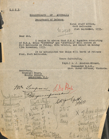
Document - Memorandum, Melbourne & Metropolitan Tramways Board (MMTB), Procession of 7th Division, AIF, through city streets, 8/02/1946 12:00:00 AM
... Procession of 7th Division, AIF, through city streets ...Procession of 7th Division, AIF, through city streets Wednesday 19 April 1944 - 1:20PM to 2:20PM 4 memos from JM Harry, Dist Traffic Supt SS regarding tram arrangements to various inspectors. Memos dated 14 April 1944. Vic L of C Area March Order No 2/44"McKenzie" & "Little" written in black ink on relevant memostrams, tramways, events, parades, hanna st depot, malvern depot, hawthorn depot, camberwell depot -
 Greensborough Historical Society
Map, Melbourne and Metropolitan Board of Works. Survey Division, MMBW, Yarra 2500 / 16.23. Diamond Creek, 1978_02
Melbourne and Metropolitan Board of Works. Yarra 2500 [base map] 16-23. Diamond Creek. Parish of Nillumbik 3310. Municipalities of Diamond Valley 257 and Eltham 238. Prominent streets include: Phipps Crescent, Bishop Avenue, and Reynolds Road. Includes the former Diamond Creek Technical School.MMBW Map in 1:2500 [scale] series. Cream parchment with green tape reinforcing on edges and punched holes on left edge.mmbw, melbourne and metropolitan board of works, shire of diamond valley, diamond creek - maps -
 Greensborough Historical Society
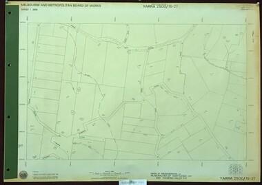
Map, Melbourne and Metropolitan Board of Works. Survey Division, MMBW, Yarra 2500 / 15.27. Yarrambat, De Fredricks Lane, 1977_10
Melbourne and Metropolitan Board of Works. Yarra 2500 [base map] 15.27. Yarrambat, De Fredricks Lane. Parish of Greensborough 2724. Municipality of Diamond Valley 257 and Whittlesea 239. Prominent streets include: De Fredricks Lane, Astons Road and Bannons Lane. Features include Scrubby Creek.MMBW Map in 1:2500 [scale] series. Cream parchment with green tape reinforcing on edges and punched holes on left edge.mmbw, melbourne and metropolitan board of works, shire of diamond valley, yarrambat - maps -
 Bendigo Military Museum
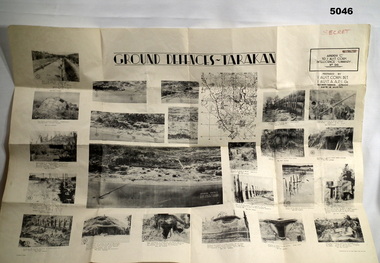
Poster - POSTER, GROUND DEFENCES "TARAKAN", 1 Aust Corps Det. A.A.P.I. Gn, Ref map Tarakan 1/25000, 8 August 1945
Francis Hansen VX85668 2/3rd Infantry Battalion.Cream coloured Paper, Black Printed map with 23 photographs on it.Ground Defences Tarakanposter, photographs, tarakan -
 Melbourne Tram Museum
Document - Memorandum, Melbourne & Metropolitan Tramways Board (MMTB), "Parade of Air Force Personnel (Males Only) through city streets Friday 15th October, 1943", Oct. 1943
... streets Friday 15th October, 1943" ..."Parade of Air Force Personnel (Males Only) through city streets Friday 15th October, 1943" Three memos from JM Harry, Dist Traffic Supt SS regarding tram arrangements for above event. Letter from GJ Dean, acting town clerk, dated 9 Oct '43, with attachment of march orders, dated 15 Oct '43.Notations written in pencil on memo.trams, tramways, events, parades -
 Melbourne Tram Museum
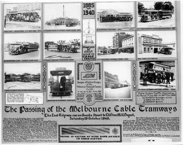
Photograph - Black and White, Melbourne & Metropolitan Tramways Board (MMTB), "The passing of the Melbourne Cable Tramways", 1940
"The passing of the Melbourne Cable Tramways", featuring photographs of first cable tram, Fitzroy power house, cable trams in the street, Nicholson St, the No. 1 tram entering the National Museum, some historic notes on the construction of the system, its operations, MMTB takeover, a drawing of the grip and of the badges and buttons used and an image of the cable used. Notes that it was compiled by A. R. Turnbull with co-operation of F. King, K.L.Mackenzie and H. G de Mamiel. Original poster prepared by the MMTB and presented to the State Library or the Museum of Victoria at the time of closure. See Reg Item 2854 for a framed photograph and 6368 for another poster of the time - Melbourne tramways past and present poster Yields information about the Melbourne cable tram system and its history. Photograph - of a MMTB Poster titled - "The passing of the Melbourne Cable Tramways"tramways, trams, cable trams, closure, museums, melbourne -
 Melbourne Legacy
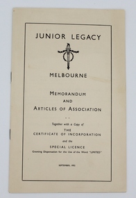
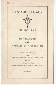
Booklet, Junior Legacy, Melbourne. Memorandum and Articles of Association, September 1952
This document records the legal status of 'Junior Legacy, Melbourne' in 1952. Melbourne Legacy has had name changes over the years. In September 1952 Junior Legacy Melbourne was incorporated. Under the provisions of the Companies Act 1938, it was registered as a company with limited liability without the need for 'limited' in its' name (see page 1). Another copy of this document was stored in the 'History of Legacy' files as 'H17' (01490) when the original archive project was undertaken by Legatees Frank Doolan and Brian Armstrong.A record of a former entity of Melbourne Legacy. The incorporation was under the companies act 1938. Booklet of white paper cover and 12 pages of black type which documents the offical incorporation of 'Junior Legacy, Melbourne'.history, regulations -
 Melbourne Legacy
Booklet, Junior Legacy, Melbourne. Memorandum and Articles of Association. (H17), 1952
This document records the legal status of 'Junior Legacy, Melbourne' in 1952. Melbourne Legacy has had name changes over the years. In September 1952 Junior Legacy Melbourne was incorporated. Under the provisions of the Companies Act 1938, it was registered as a company with limited liability without the need for 'limited' in its' name (see page 1). Two other copies are at 00317 and 00985. This is marked in red pen with 'H17' when the original archive project was undertaken by Legatees Frank Doolan and Brian Armstrong.A record of a former entity of Melbourne Legacy. The incorporation was under the companies act 1938. White paper booklet with black type x 12 pages which documents the offical incorporation of 'Junior Legacy, Melbourne'.Handwritten H17 in red pen.history, regulations -
 Stawell Historical Society Inc
Map, Easton Johnstone, Map of Stawell Surveyed by Easton Johnstone 1872, 1872
Victoria Co Crushing Machine. St Georges Co Crushing machine. Wimmera Co Crushing Machine. Government Reservoir and Drainage. Sloan Street, Skene Street Mines. old Mine WorkingsA2 map of Stawell Reefs Area. Showing Crushing Machines & Title InfoSurveyed by Easton Johnstone Contract Surveyor. Photo-Lithographed at the Department of Lands & Survey. Melbourne By J Noone 9th May 1872mining -
 Eltham District Historical Society Inc
Photograph, George Coop, A day in Melbourne, northwest corner, Mont Albert and Balwyn roads, November 1962, 1962
... Balwyn roads, November 1962 ...Modern building now on vacant block of land in frontDigital TIFF file Scan of 35mm Ilford FP3 black and white transparencybalwyn road, houses, melbourne, mont albert road -
 City of Greater Bendigo - Civic Collection
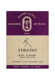
Programme, Wilke and Co Ltd, Olympic Games Melbourne Australia 1956 : Athletics, Main Stadium (Melbourne Cricket Ground), Friday, 23rd November, 1956, 1956
Held in Melbourne from the 22nd November to 8th December, the 1956 Summer Olympics, officially known as the Games of the XVI Olympiad or the Melbourne Olympics were the first held outside of Europe or the USA. The Olympic torch relay passed through Central Victoria on its way from Cairns to Melbourne. Small book containing 15 pages including map of competition venues and programme on the back cover. Front cover depicts male javelin thrower. Printed in black and purple ink.melbourne olympic games, city of greater bendigo tourism -
 Greensborough Historical Society
Map, Melbourne and Metropolitan Board of Works. Survey Division, MMBW, Yarra 2500 / 13.24. Plenty, Memorial Drive, 1979_03
Melbourne and Metropolitan Board of Works. Yarra 2500 [base map] 13-24. Plenty, Memorial Drive. Parish of Morang 3183. Municipalities of Diamond Valley 257 and Whittlesea 239. Prominent streets include: Oatland Road, River Avenue and Memorial Drive. Includes Plenty River and SEC Transmission easement.MMBW Map in 1:2500 [scale] series. Cream parchment with green tape reinforcing on edges and punched holes on left edge.mmbw, melbourne and metropolitan board of works, shire of diamond valley, plenty - maps -
Clunes Museum
Map, A.C. BROOKS GOVERNMENT PRINTER MELBOURNE, EGLINTON COUNTY OF TALBOT, 1965
MAP OF EGLINTONMAP OF EGLINTON, COUNTY OF TALBOT PRINTED ON CANVAS WITH PLASTIC TAB FOR HANGING. MAP SHOWS TOWN ALLOTMENTSADMINISTRATIVE STAMP ON BOTTOM LEFT AND ON THE BACK OF THE MAP ANOTHER STAMP - NORTHERN DIVISION (299) FORESTS COMMISSION BENDIGOeglinton, historical map -
 Kiewa Valley Historical Society
Map - Kiewa Valley, County Map of Bogong, 27/11/1905
This map has been owned by the Ryder Family of the Kiewa Valley for possibly over 100 years (1905?). It was used when the family mustered and maintained cattle on their grazing lease on the Bogong High Plains. Obviously a field map used on these occasions.This map was used by the Ryder Family who lived in the Kiewa Valley and who grazed cattle on their lease on the Bogong High Plains during summer.Showing reserves Under the Forest Act of 1907. This is a paper map which has been mounted or glued on pink and cream floral cotton. It is obvious by its poor condition that it has been used outdoors in the field. It is not in very good condition as it has been folded 4 times (8 divisions) and it is badly worn and cracked in the creases.Photo Lithographed at the Department of Lands and Surveys by T.E.McGauran 27/11/05 Price 1/3d. Scale - 2 miles to an inch. F.S. Hilcke Oct. 2nd 1905.department of lands and surveys map; ryder family; bogong high plains -
 Melbourne Tram Museum
Document - Memorandum, Melbourne & Metropolitan Tramways Board (MMTB), "Parade of Returned AIF Personnel, through city streets", 15/11/1943 12:00:00 AM
... "Parade of Returned AIF Personnel, through city streets" ...Parade of Returned AIF Personnel, Through City Streets Thursday 18th November 1943 - 1.20 to 1.55 PM 1 - Several memos from JM Harry, Dist Traffic Supt, to depots for tram arrangements for above event. Provides details for parking and shunting of tramcars. 2 - Letter from HS Wootton, Town Clerk, to M&MTB regarding traffic and march arrangements for above event.trams, tramways, letters, instructions, events, parades, world war 2, city rd, swanston st, victoria st, hawthorn depot, camberwell depot -
 Kew Historical Society Inc
Plan, Melbourne & Metropolitan Board of Works : Borough of Kew : Detail Plan No.1573, 1905
The Melbourne and Metropolitan Board of Works (MMBW) plans were produced from the 1890s to the 1950s. They were crucial to the design and development of Melbourne's sewerage and drainage system. The plans, at a scale of 40 feet to 1 inch (1:480), provide a detailed historical record of Melbourne streetscapes and environmental features. Each plan covers one or two street blocks (roughly six streets), showing details of buildings, including garden layouts and ownership boundaries, and features such as laneways, drains, bridges, parks, municipal boundaries and other prominent landmarks as they existed at the time each plan was produced. (Source: State Library of Victoria)This plan forms part of a large group of MMBW plans and maps that was donated to the Society by the Mr Poulter, City Engineer of the City of Kew in 1989. Within this collection, thirty-five hand-coloured plans, backed with linen, are of statewide significance as they include annotations that provide details of construction materials used in buildings in the first decade of the 20th century as well as additional information about land ownership and usage. The copies in the Public Record Office Victoria and the State Library of Victoria are monochrome versions which do not denote building materials so that the maps in this collection are invaluable and unique tools for researchers and heritage consultants. A number of the plans are not held in the collection of the State Library of Victoria so they have the additional attribute of rarity.Original survey plan, issued by the MMBW to a contractor with responsibility for constructing sewers in the area identified on the plan within the Borough of Kew. The plan was at some stage hand-coloured, possibly by the contractor, but more likely by officers working in the Engineering Department of the Borough and later Town, then City of Kew. The hand-coloured sections of buildings on the plan were used to denote masonry or brick constructions (pink), weatherboard constructions (yellow), and public buildings (grey). This plan has detailed annotations written in red or blue ink, showing prices, which may be the annual valuations of the properties, and some owners’ names, a most unusual feature on contractor's maps. Some areas, such as the buildings of Methodist Ladies’ College (MLC), include the school’s tennis court and swimming pool, but are not coloured to show building materials – did the draftsman just run out of time, or ink, or enthusiasm, before his plan had to be submitted? MLC had been founded in 1882 as a ‘modern school of the first order’ with buildings that formed ‘a collegiate institution for girls unsurpassed in the colonies’. The goal of its founders was to provide a high-class Christian education for girls, comparable with that provided elsewhere for boys. Some shops are shown along Edgevale Road, though they are not designated as commercial premises. Larger houses are depicted, including ‘Fairlawn’ in Barkers Road, and ‘Clevedon’ and ‘Rosehill’ (now demolished) in Fitzwilliam Street.melbourne and metropolitan board of works, detail plans, mmbw 1573, maps - borough of kew, cartography -
 Wangaratta RSL Sub Branch
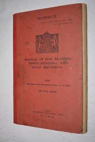
Manual - Book, Manual of Map Reading Photo Reading and Field Sketching, 1948
Official copy of War Office Manual of Map Reading Photo Reading and Field Sketching.Red bound book with black writing and British crest.Manual of Map Reading Photo Reading and Field Sketching 1929 The War Officemanual of map reading photo reading and field sketching., war office -
Port Melbourne Historical & Preservation Society
Book, Jeff Leeuwenburg, "The Making of Melbourne in Maps", 1987
"The Making of Melbourne in Maps" by Jeff Leeuwenburg (1987), includes maps of Melbourne from 1836 to 1930built environment, jeff leeuwenburg -
 Whitehorse Historical Society Inc.
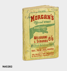
Map - Street directory, Morgans Official Street Directory
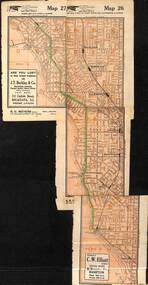
Morgan's street directories lack dates. Donor's parents, who lived in Blackburn, used this street directory .Small soft covered book of official street directory of Melbourne and suburbs.Morgans Official Street Directory Melbourne and Suburbs 6/6maps -
 Warrnambool and District Historical Society Inc.
Map - Fire Maps, Region 5 Fire Control Map, 1963
Two fire maps of south west Victoria.1 This is a rectangular piece of linen folded several times to form a packet with the front part covered with a brown card. The cover has a blue and white label. The map has a white base with red and green markings and red and black printing .2 As .1 abovenon-fictionTwo fire maps of south west Victoriafire maps, warrnambool history