Showing 458 items matching "subdivision map"
-
 Melbourne Tram Museum
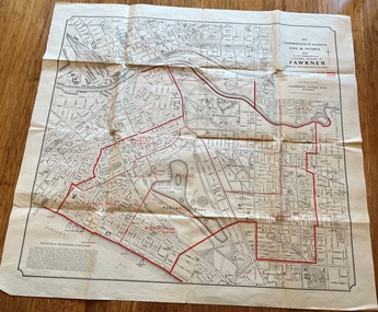
Map, Department of Lands and Survey Melbourne, Commonwealth Electoral Division of Fawkner, 1-10-1912
Shows a detailed street plan of South Melbourne, Albert Park, Prahran, South Yarra and parts of Melbourne in 1912. Used to mark the electoral boundaries of the Commonwealth Electoral Division of Fawkner. Shows all the then cable tram lines, rail lines and the electric line of the PMTT along with docks, gardens and significant buildings.Gives details of the Fawkner Electoral district in 1912.Folded sheet - Map - Commonwealth Electoral Division of Fawkner - two colours showing the subdivisions and polling placesmelbourne, fawkner, tram lines, cable trams, maps, electoral maps, south melbourne, albert park, prahran -
 Ringwood and District Historical Society
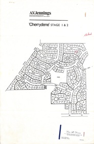
Flyer, Land Sale Advertisement - Cherrydene Estate, Stage 1 & 2, Ringwood, Vic. - 1969
Subdivison map of Cherrydene Estate and double-sided A4 size House & Land price list dated 27/10/1969. Developer - A.V. Jennings Industries (Aust) Ltd., Cnr. Springvale & Wellington Rds., Mulgrave, Vic. Phone 560 8411. Sales Dept. Rep., Leon B. Devine, Phone 560 8411 A/H.435 5311. Subdivision includes Wonga Road, Holyrood Crescent, Clipper Court, Ripley Court, Harwick Close, Bader Court, Towerhill Drive, Nigel Court, Berkley Road, Avis Court, Carmen Close, Frederic Drive, Kenwood Crescent, Adele Court, Marilyn Street, Abbey Court, Baron Court, Kismet Close, Oban Road, Ringwood.Furnished and landscaped display homes are open for your inspection, (see map on reverse side) from 11 a.m. to 5 p.m. Sundays and Holidays, and 2 p.m. to 5 p.m. weekdays and Saturdays. Display homes list for 'Cherrydene' Ringwood - Arundel, Ashmoor, Avalon, Cleveland, Chiltern, Dorset. -
 Ringwood and District Historical Society
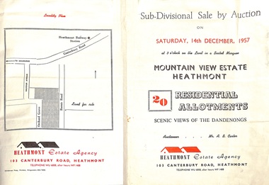
Flyer - Land Sales Brochure, Sub-Divisional Sale by Auction - Mountain View Estate, Heathmont, Victoria - 1957
Bi-fold pamphlet advertising auction of 20 residential allotments on Saturday, 14th December, 1957, with description of services available and finance terms. Subdivision inclues Orchard Grove and Barnic Road. Agent - Heathmont Estate Agency, 103 Canterbury Road, Heathmont, Telephone WU6808, after hours WF1488. Auctioneer Mr. A.B. Carter. Accompanying Parish of Ringwood survey map with cardboard backing - Part of Crown Allotment 14B, includes handwritten price notations for each allotment. -
 Ringwood and District Historical Society
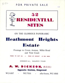
Flyer, Land Sale Brochure, Heathmont Heights Estate, Heathmont, Vic. - 1959
... , including map and summary of subdivision features and local..., including map and summary of subdivision features and local ...Bi-fold advertisement for sale of residential sites, including map and summary of subdivision features and local facilities. Subdivision includes Coven Avenue, View Court, and Miller Road. Agent - A.W. Dickson, Opposite Station. (Phone) WU6007, WU7016, after hours WU6868. Accompanying Titles Office Plan of Subdivision photocopy dated 1971 - Part of Crown Allotment 38A Parish of Ringwood. -
 Ringwood and District Historical Society
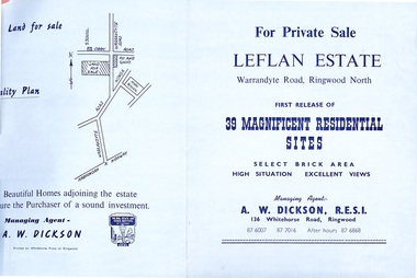
Document - Folder, Land Sale - Leflan Estate, North Ringwood, Vic. - circa 1967
Bi-fold land sale advertisements for stages 1 and 3 releases of residential allotments in Leflan Estate, Ringwood North, circa 1965-1967. Brochures include area map, layout of the estate, and summary of local facilities and services, with separate attachment listing lot number prices for 2nd and 3rd releases.Subdivision includes Melview Drive, Leslie Grove, Leflan Close, Warrandyte Road and Lockhart Street. Agent - A.W. Dickson, R.E.S.I., 136 Whitehorse Road, Ringwood. (Phone) 870-6007, 870-7016, After hours 870-6868. -
 Ringwood and District Historical Society
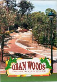
Document - Land Sale Folder, Oban Woods Subdivision, Ringwood North, Vic., - circa 1997
... Lots 6 to 12 of Oban Woods Estate with location map and summary... of Oban Woods Estate with location map and summary of subdivision ...Folder containing multi-fold colour pamphlet advertising Lots 6 to 12 of Oban Woods Estate with location map and summary of subdivision features. A4 size attachments include subdivision layout of Lots 2 to 25 with summary of property sizes and undated indications of whether sold or still available at the time, with price where known. Dates not documented however early sales within the development took place around 1997.Estate plan includes Oban Woods (thoroughfare) and Chifley Parade. Location map of area shows development site of Oban Woods Estate off Oban Road and Kubis Drive, Ringwood North. Agents - R.E. Appleby Ringwood Pty Ltd., 170 Warrandyte Road Ringwood North 3134, Telephone 9876 4222, Fax 9876 4209. -
 Ringwood and District Historical Society
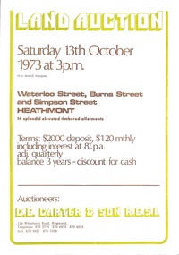
Document - Folder, Land Auction - Peacock's Estate, Waterloo Street, Heathmont, Victoria - 1973
Photocopy of Certificate of Title and double sided bi-fold leaflet advertising auction of 14 allotments on 13th October 1973 with map of streets, summary of local services and terms of sale. Subdivision includes Waterloo Street, Burns Road (later Dirkala Avenue), and Simpsons Road (later Simpsons Court). Auctioneers - C.E. Carter & Son R.E.S.I. 126 Whitehorse Road, Ringwood, Telephone 870 2519, 870 6830, 870 6024, A.H. 870 0421, 870 3568.Auctioneer's notation of sale prices included on brochure - all sold on day of auction. Vendor Frank Harry Peacock, Tile Burner, named as proprietor of Lot 12 on Plan of Subdivision No. 95654 on Title (Vol 8999 Fol 058). Map shows Dandenong Creek Watercourse as at September, 1971, prior to Dandenong Creek Trail development. -
 Ringwood and District Historical Society
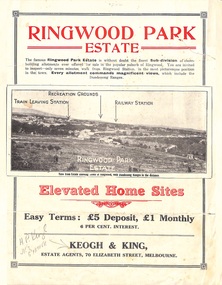
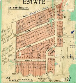
Flyer, Sub-divisional residential land sale advertisement - Ringwood Park Estate, Ringwood, Vic. - circa 1922
Folded double-sided page with black and white photographs of local views with black and red print advertising elevated home sites, including terms of sale, locality map, and description of local facilities and services, with blocks marked as SOLD subsequent to auction sale December 1922. (See Record ID no.5249)Subdivision includes Wonga Road (later Loughnan Road), William Street, Andrew Street, Munro Street and Harrison Street. Estate Agents - Keogh & King, 70 Elizabeth Street, Melbourne, Telephone 6938. -
 Canterbury History Group
Article, Don Gibb, The Elgar's Special Survey
... Canterbury McWilliam. Gwen Land Subdivision Port Phillip ...Copy of a talk given by Don Gibb to the Canterbury History Group in June 2015 on the Elgar Survey which will be the basis of the second chapter of his forthcoming book on the social history of Canterbury. Includes maps and a list of the first Boroondara ratepayers.canterbury, mcwilliam. gwen, land subdivision, port phillip district, maps, gibb> don -
 Bacchus Marsh & District Historical Society
Map, Lerderderg Park Lands sale plan. 1911
This plan was for the sale of parcels of land from the Lerderderg Park Estate property in 1911. Advertising for the sale appeared in the Bacchus Marsh Express newspaper through July of 1911. The property was situated only a few kilometers from the township of Bacchus Marsh. The agents for the sale were L. A. Fairbairn & Co.Lerderderg Park Estate was a significant and early colonial property in the Bacchus Marsh area. This plan provides details about the first time the property was subdivided for sale. It is therefore documents an important moment in the history of this property and the broader trend of the subdivision of older and larger properties in the district.A single page paper plan showing allotments of land for sale from the Lerderderg Park property owned by John Wills. The parcels of land for sale are coloured in red.The Lerderderg River and Pyke's Creek Irigation Channel shown on the plan are in blue ink. The rest of the plan is a dark cream or beige colur with the text in black ink. The plan has been extensively annotated with hand-written notes indicating the names of people who purchased the various parcels of lands and the prices paid for those lands. Part of the top of the plan containing some text appears to be missing. The plan is pasted into a bound volume containing 76 maps or plans in total. Top: Have received instructions to Sell, account Mr John Wills, his renowned LERDERDERG PARK LANDS, so well and favourably known throughout the Commonwealth. In areas from 3 acres to 1276 acres. Every lot is either rich lucerne land (or portion now under lucerne) with some higher land adjoining Railway Station, and 2 Milk factories within 2 miles, absolutely the finest land in Victoria. Bottom: THIS IS THE FIRST SUBDIVISIONAL SALE of Rich Flats in Bacchus Marsh since the Pyke's Creek Scheme, and every lot is commanded by it. Only 32 miles from Melbourne.bacchus marsh victoria maps, land sales, lerderderg park estate, land subdivision -
 Ringwood and District Historical Society
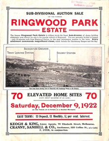
Flyer, Sub-divisional auction sale advertisement - Ringwood Park Estate, Ringwood, Vic. - 1922
Folded double-sided page with black and white photographs of local views with black and red print advertising auction sale on Saturday 9th December, 1922, - 70 residential home sites, including terms of sale, locality map, and description of local facilities and services. Subdivision includes Wonga Road (later Loughnan Road), William Street, Andrew Street, and Harrison Street. Vendors Solicitors - Rigby & Fielding, 60 Market Street, Melbourne. Estate Agents - Keogh & King, 70 Elizabeth Street, Melbourne, Telephone 6938. Auctioneer - Cranny, Sambell & Co., 325 Collins Street, Melbourne, Telephone Central 5067 and 5077. -
 Ringwood and District Historical Society
Map, Plan of Subdivision - Mullum Mullum Road, Ringwood - Circa 1969
Photocopy of subdivision - 128 residential allotments in Mullum Mullum Road, Sonia Street, Linda Drive, Jill Court, Eve Court, and Alma Court, Ringwood. -
 Ringwood and District Historical Society
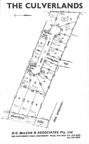
Document, Subdivision Plan - The Culverlands Estate, Heathmont, Victoria (undated, circa 1968)
Map of residential allotments for sale, with handwritten pricing notations and some marked "Sold". Subdivision includes Culverlands Road, Swain Court, Pleasant Drive, Barbara Court, and Armstrong Road, Heathmont. Agent - H.G. McLean & Associates Pty. Ltd., 166 Canterbury Road, Heathmont Vic., 3135, Telephones : 870-3422 A/hrs 870-5879 and 729-2809. -
Canterbury History Group
Document - Thematic Environmental History, Built Heritage, 1/05/2012
Thematic Environmental Heritage. Final document produced, after community consultation, for the City of Boroondara by Built Heritage242 pages city of boroondara, back yards, canterbury, churches, cottages, dairies, danks family, elgar survey, exploration, frognall, goldings boot factory, maling road, malone's hotel, maps, masonic lodges, national parks, native plants, outer circle railway line, police stations, post offices, railways, rochester road, schools, shrublands, soldiers memorial hall, sport, telephone exchanges, theatres, transport, wildlife, canterbury road, land subdivisions, parks and reserves -
 Ringwood and District Historical Society
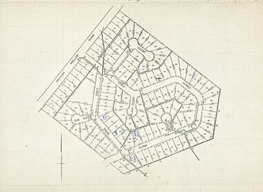
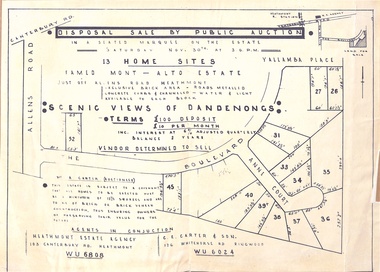
Flyer - Auction, Mont-Alto Estate, Heathmont, Victoria - circa 1960
Single page advertisement for auction of 13 home sites on Saturday 30th November (1957?) with map of subdivsion, terms of sale, and reference to brick covenant. Subdivision includes Yallamba Place, The Boulevard, and Anne Court, Heathmont. Agents - Heathmont Estate Agency, 103 Canterbury Road, Heathmont (Telephone) WU6808, and C.E. Carter & Son, 126 Whitehorse Road, Ringwood, WU6024. Auctioneer - Mr. A. Carter."This Estate is subject to a covenant that all homes to be erected must be a minimum of 12-1/2 squares and are to be of brick or brick veneer construction, thus ensuring owners of preserving their value for the future." -
 Warrnambool and District Historical Society Inc.
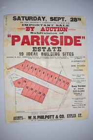
Work on paper - Original Document, H J Paynter, Advertisement "Parkside"Estate subdivision, Circa 1935
This sheet denotes an auction of land which is situated close to Albert Park on the northern part of Warrnambool. The area is complete now with homes which are a mixture of brick and concrete faced houses. The agent W H Philpott was operating in Warrnambool from the 1930's though to 1950'sThis item has local interest and significance as it records the sale of Warrnambool land.Large white paper sheet with black and red text. The auction details are at the top and down the righthand side with a map of the available blocks are coloured red and outlined in black.Parkside estate, W H Philpott & Co Kepler St , R V Philpott auctioneer,Solicitors J S Tait & son. Cramer Street, Nelson Street McConnell Street.warrnambool, mcconnell street warrnambool -
 Ringwood and District Historical Society
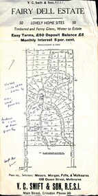
Flyer, Residential Land Sale Sub-division - Fairy Dell Estate, Warranwood, Vic. - circa 1950s
Land sale advertisement for 50 home sites with map of Sub-division showing layout of streets and allotments, summary of local features and services and terms of sale, and copy of sectional map of Crown Allotments 20 & 21B Parish of Warrandyte also showing layout of Sub-division.Subdivision includes Grandview Grove (later Bemboka Road), Merrill Crescent and Kerry Road, Warranwood. Estate Agents - V.C. Swift & Son R.E.S.I., Main Street, Croydon, Phone 20. Solicitors - Morgan, Fyffe & Mulkearns, 108 Queen Street, Melbourne. Handwritten 1970s real estate price notations for some blocks. -
 Ringwood and District Historical Society
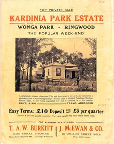
Flyer, Land Sale Brochure, Kardinia Park Estate, North Ringwood, Vic. - circa 1948
Folded buff-coloured land sale advertisement for Kardinia Park Estate in Warranwood area of North Ringwood, including terms of sale, area map, layout plan of the estate, and summary of local facilities and services. Front page features photograph of a man and dog in front of a house captioned as Lot 1 on four acres shown on the estate layout as cnr of Brysons Road and Range View Parade (later Omeo Parade). Second page includes bushland swimming pool photograph and promotional information for prospective buyers.Subdivision includes Kardinia Crescent, Wonga Road, Brysons Road, Range View Parade (later Omeo Parade), Motor Coach Road (later Wonga Park Road, then Warranwood Road). (Agent/s) T.A.W. Burkitt, Main Street, Ringwood, Phone (9 to 6) Ringwood 242, Evenings, Ringwood 157, and J. McEwan & Co, 317 Collins Street, Melbourne, Phone 6750 Central. -
 Whitehorse Historical Society Inc.
Map - Civic Map, Subdivision of Village of Springfield, 1861
... Map of the subdivision of the Springfield Estate... subdivision map of the Nunawading area, part of the Vale Collection ...Map of the subdivision of the Springfield Estate, Nunawading, 1861. The Springfield Estate was located in the Northwest corner of Whitehorse Road and Springvale Road.Map of the subdivision of the Springfield Estate, Nunawading, 1861. Springfield Estate was located in the Northwest corner of Whitehorse Road and Springvale Road.non-fictionMap of the subdivision of the Springfield Estate, Nunawading, 1861. The Springfield Estate was located in the Northwest corner of Whitehorse Road and Springvale Road.springfield estate, whitehorse road nunawading, springvale road nunawading -
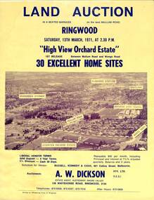 Ringwood and District Historical Society
Flyer, Land Auction Sale Brochure, High View Orchard Estate, Ringwood, Vic. - 1971
Double-sided advertisement for Ringwood High View Orchard Estate land auction sale on Saturday, 13th March, 1971, including aerial photograph, map, and summary of local facilities and services.Subdivision includes Wonga Road, Oban Road, Sang Court, Ambrie Avenue, Hendra Grove, and Mullum Mullum Road. Agent - A.W. Dickson Pty. Ltd., 136 Whitehorse Road, Ringwood, 3134. Telephones: 870 6000, 870 6007, 870 7016, after hours 870 6868. A separate copy of the advertisement includes a local newspaper follow-up clipping reports thirty home sites grossing $102,350 at the auction. -
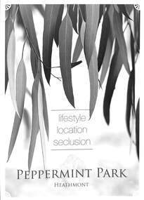 Ringwood and District Historical Society
Flyer, Residential Land Sale Brochure, Peppermint Park, Heathmont, Vic. - 2010
Double-sided A3 size advertisement for Peppermint Park, Heathmont, Victoria, advertising sale of ten homesites with diagram showing locality map, size of blocks and layout of streets within and around the subdivision.Subdivision layout includes Pleasant Drive, Swain Court and Barbara Court off Culverlands Road and Armstrong Road in Heathmont. Agents - Carter Real Estate Agency, 90 Maroondah Highway, Ringwood Vic 3134 (Telephone) 98706211. Auctioneers - Richard Carter & William Lyall - 0411823337. Handwritten price list notations included, and Stage 2 Plan digitally signed by Michael Herwald Hipfel, Licensed Surveyor, 10/2/1916. -
Canterbury History Group
Map - Canterbury Subdivisions
... A collection of 6 maps with notations showing the names ...A collection of 6 maps with notations showing the names and dates of land subdivision in Canterbury and surrounding suburbs.canterbury, logans estate, shrublands estate, claremount park estate, arklow hill estate, griffin estate, monomeath estate, mont albert park estate, great railway estate, grange estate -
 Ringwood and District Historical Society
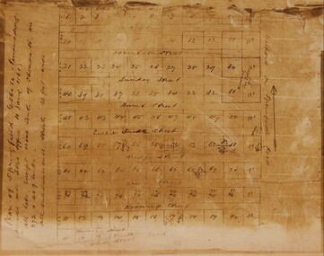
Map - Plans of Subdivision, Part of Crown Allotments 35 & 39, Parish of Warrandyte
... & 39, Parish of Warrandyte Map Plans of Subdivision ...Survey maps of stages 1, 2 & 3 of residential allotments in Kalinda Road and Grayling Crescent, Ringwood, Victoria. (Undated, circa 1960). Some allotments are marked with real estate information and prices in pre decimal £s.Adshead & McGuire, Land Surveyors L.S. M.I.S. (Aust), 268 Albert Street East Melbourne (Ref 118/2a b &c) Tel 41-6960. The land colored blue is set apart for drainage & sewerage purposes. Reference Marks (R.M's) are Gal Iron Pipes 12"x1". Levels shown are to M.M.B.W. Datum. The land shown hatched is subject to innundation. -
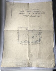 Luther College
Map, Plan of Subdivision, 1957
... This map shows the original subdivision of land...This map shows the original subdivision of land ...This map shows the original subdivision of land on the corner of Plymouth Road and Yarra Road. The land previously belonged to Phillip Brucker, who used the property as a small farm. Brucker offered his land at a reduced price to the Lutheran Church, who were seeking a location for their new secondary school endeavour.This is the oldest map of Luther Collegemap, building plans -
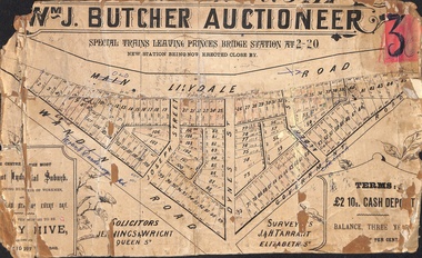 Ringwood and District Historical Society
Poster - Land Sale, Wm J. Butcher, Auctioneer - Albert Park Estate, Ringwood - c.1890
Central section of land sale subdivision advertisement glued to heavy cardboard backing. Photocopied SLV image of original advertisement shows map of 117 allotments for sale in Main Lilydale Road (later Old Lilydale Road), Wandin Road (later Mount Dandenong Road), Joseph Street, Dynes Street, Albert Street (later Wyrunga Street) and Government Road (later Carcoola Road), Ringwood East.Solicitors - Jenningw & Wright, Queen Street. Surveyors - J.&H. Tarrant, Elizabeth Street. Terms £2 10s cash deposit, balance three years at six per cent. -
 Ringwood and District Historical Society
Map, Subdivision Plan, Loughnans Road, Ringwood - circa 1922
Green card with cut-out map of residential allotments, some marked "sold". "Plan of Estate" includes Wonga Road, Loughnans Road, William Street, Andrew Street, Harrison Street, and Munro Street, Ringwood. (Surrounding area is part of Ringwood Park Estate featured in seperate 1922 auction flyer).Handwritten notations - (northern section) {£2-10/- per foot. £5 deposit bal £1 per month} All the rest £2 per foot, value same as above. Licensed Surveyors - W.J. & A.W. Kenhardt, 352 Collins Street, Melbourne. -
 Ringwood and District Historical Society
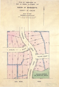
Document - Real Estate Folder, Savernake Estate, Ringwood, Victoria - Stage two - circa 1967
Plan of Subdivision PS79692, Part of Crown Allotment 31A Parish of Warrandyte, and advertisement for sale of residential allotments with map showing layout of Stage 2 of subdivision. Typewritten details for first and second release of Lots 10 to 16 with Terms of sale, stapled to two advertising flyers featuring map of estate showing Lots 1 to 20 on Evelyn Road, Cameron Road, Klead Court, and San Remo Road. Green slip included dated 6 July 1979 showing description of property at Lot 14 (no.4) San Remo Road, vendor - Judith Margaret Love and Lindsale Stephen Love, Cherry Tree Downs, Tarwin Lower 3456. Phone 056635390 Bus 056787203.Agent - C.E. Carter & Son, R.E.S.I. 126 Whitehorse Road, Ringwood. Telephones: 8706024, 8706830, 8702519, A.H.: 7233298, 8782648. Subdivision Plan stamped Donald Cameron Consultants Pty. Ltd., Consulting Engineers, 472 Bourke Street Melbourne - 67-2602. -
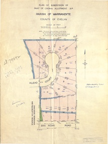
 Ringwood and District Historical Society
Document - Real Estate Folder, Savernake Estate, Ringwood, Victoria - Stage one - 1967
... Plan of Subdivision, Part of Crown Allotment 31A...Subdivision includes Evelyn Road, Cameron Road, Klead Court ...Plan of Subdivision, Part of Crown Allotment 31A and advertisement for sale of residential allotments with map showing layout of subdivision. Typewritten pricelist attached outlining suggested terms of sale as of 14 September, 1967.Subdivision includes Evelyn Road, Cameron Road, Klead Court, and San Remo Road. Agent - C.E. Carter & Son., 126 Whitehorse Road, Ringwood. (Phone) 87-6024, 87-6830, 870-2519, After hours: 723 3298, 878 2648. Subdivision Plan stamped Donald Cameron Consultants Pty. Ltd., Consulting Engineers, 472 Bourke Street Melbourne - 67-2602. -
Glen Eira Historical Society
Album - Photograph Album, Beauville Estate Album, 2001
Originally labelled "Beauville Estate, Established 1936, Still Thriving 65 years on, 10th March 2001", the Beauville Estate Album contains colour photographs of houses in the Estate. They were taken around the time of the Beauville Estate’s 65th Heritage Celebration held on 10/03/2001 and donated to the Caulfield Historical Society shortly afterwards. Photographer Bev Baxter. Glen Eira’s Heritage Management Plan by Andrew Ward (1996) Vol 2 p78 states that by the end of 1934, the first 3 houses had been built in this housing estate.City of Glen Eira’s Heritage Management Plan Vol 2 p79 (p84 of the pdf version) – HO12 Beauville Estate and environs, Murrumbeena: The Beauville Historic Area is important at the State level as the first large housing estate undertaken by the AV Jennings Construction Co, later Jennings Group Limited, Victoria’s largest home builder. It is important also as a very early estate development incorporating a range of features other than houses and including made roads, shops and recreation facilities. In this respect it was the forerunner of the comprehensively planned housing estate of the post war era. The estate is distinguished by its aesthetic values, as is the earlier and comparable Hillcrest Estate, which are formed by a combination of restrained diversity in house styles, with the exception of no. 30 in the emerging International style, and by a landscaped garden environment.Colour photographs of house exteriors, as well as parks and tennis courts on the Beauville Estate. murrumbeena, houses, beauville avenue, architectural styles, 1930's, inter war style, a.v. jennings, av jennings, jennings, brick houses, beauville estate, murrumbeena road, lindsay avenue, gloucester court, dalny road, a v jennings construction co, beauville estate heritage area, glen eira city council, architectural features, plans, shops, residential development, tennis courts, housing estates, builders, building regulations, local government, commercial development, history, maps, photographs, commercial establishments, jennings group limited, land subdivision, gardens, beauville historic area, sir albert victor jennings -
 Ringwood and District Historical Society
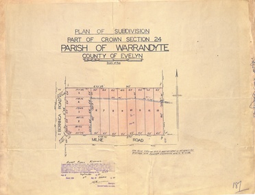
Map - Plan of Subdivision, Part of Crown Section 24, Parish of Warrandyte, County of Evelyn - 1951
... , 1951. Survey map of residential allotments in Berringa Road ...Survey map of residential allotments in Berringa Road and Milne Road, Park Orchards, Victoria. Russell Francis Kinnane, Licensed Surveyor, 4th October, 1951.