Showing 4084 items matching "surveying-terrestrial"
-
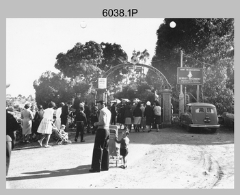
 Bendigo Military Museum
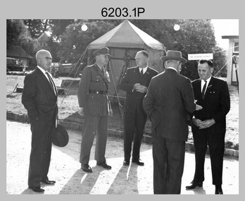
Photograph - AHQ Survey Regiment Open Day, Fortuna Villa, Bendigo, c1958
This is a set of three photographs of an Open Day held at the AHQ Survey Regiment, Bendigo c1958. It’s evident in the background of these group photos there were displays of field surveying equipment. It is known an Open Day was held on the 2nd of November 1958. As the CO LTCOL Lindsay Lockwood MID is positively identified, it’s highly probable these photos were taken at that time. LTCOL Lindsay Lockwood was the CO of the AHQ Survey Regiment from 1951 to 1962. As the longest serving commanding officer of the unit, there was many changes implemented under his command. He decided an Open Day was the best way for the local community in Bendigo to gain an insight into the unit’s important role as Defence’s map production agency, its technical equipment, and its economic importance to Bendigo. It also gave them an opportunity to tour through historic Fortuna Villa. In the background of photo .1P above the man on the right is a sign with the following text: ‘STAR OBSERVING EQUIPMENT.’ LTCOL Lindsay Lockwood’s period as CO is covered in more detail in pages 48-49 of Valerie Lovejoy’s book 'Mapmakers of Fortuna – A history of the Army Survey Regiment’ ISBN: 0-646-42120-4. Also refer to page 75 for more detailed information on the Open Day held in 1958. This is a set of photographs of an Open Day held at the AHQ Survey Regiment, Bendigo c1958. The photographs were printed on photographic paper and are part of the Army Survey Regiment’s Collection. The photographs were scanned at 300 dpi. .1) - Photo, black and white. Unidentified civilian visitors, 2nd from left: LTCOL Lindsay Lockwood MID. .2) - Photo, black and white. Unidentified Army Padre (centre) and civilian visitors. .3) - Photo, black and white. Unidentified civilian visitors..1P – annotated on back ‘COL LOCKWOOD’ .2P – no annotations .3P – annotated ‘Bishop Rich-e-a-‘royal australian survey corps, rasvy, army survey regiment, army svy regt, fortuna, asr -
 Bendigo Historical Society Inc.
Slide - AHQ,SURVEY REGT, FORTUNA,BENDIGO, April 1970
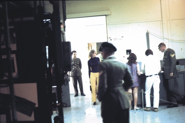
Slide. AHQ, Survey Regt, Fortuna, Bendigo. Visitors interacting with the Survey people.slide, bendigo, ahq, survey regt, fortuna, bendigo., ahq, survey regt, fortuna, bendigo. -
 Bendigo Historical Society Inc.
Slide - AHQ,SURVEY REGT, FORTUNA,BENDIGO, April 1970
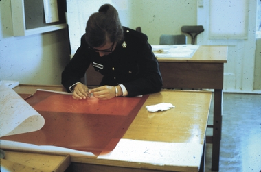
Slide. AHQ, Survey Regt, Fortuna, Bendigo. A Survey member inspecting a map.slide, bendigo, ahq, survey regt, fortuna, bendigo., ahq, survey regt, fortuna, bendigo. -
 Bendigo Military Museum
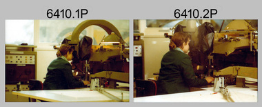
Photograph - Capturing Topographic Features with a Wild B8, AUTOMAP 1 Systems Operations – Army Survey Regiment, Fortuna, Bendigo, 1980
This is a set of 24 photographs of Air Survey Squadron technicians capturing topographic Features with a Wild B8 stereo plotter and operating AUTOMAP 1 equipment at the Army Survey Regiment at Fortuna, Bendigo, 1980. 17 of these photographs were taken of SPR Nick Van Dalen and SPR Santina (Argetto) Straube capturing topographic features – plotting with a Wild B8 stereo plotter were most likely taken in 1980. See item 6185.4P for black & white copies of photos of SPR Santina (Argetto) Straube operating the Wild B8 stereo plotter. Refer to item 6204.8P for detailed information and additional photographs of the Wild B8 stereo plotter. The history of the AUTOMAP 1 system is covered in more detail with additional historic photographs in pages 116-118 of Valerie Lovejoy’s book 'Mapmakers of Fortuna – A history of the Army Survey Regiment’ ISBN: 0-646-42120-4. See items 6122.20P, 6183.19P, 6184.20P, 6200.5P, and 6222.17P for additional photographs of the AUTOMAP 1 system.This is a set of 24 photographs of Air Survey Squadron technicians capturing topographic features with a Wild B8 stereo plotter and operating AUTOMAP 1 equipment at the Army Survey Regiment at Fortuna, Bendigo, c1980. The photographic proofs were printed on photographic paper and are part of the Army Survey Regiment’s Collection. The photographic proof prints were scanned at 600 dpi. .1) to .8) Photo, black & white, 1980. SPR Santina (Argetto) Straube operating a Wild B8 stereo plotter. .9) to .17) Photo, black & white, 1980. SPR Nick Van Dalen operating a Wild B8 stereo plotter. .18) to .24) Photo, black & white, 1980. CPL Gerry Gunn undertaking AUTOMAP 1 computer system duties..1P to .24P – no annotations.automap 1, royal australian survey corps, rasvy, army survey regiment, army svy regt, fortuna, asr, photogrammetry -
 Bendigo Military Museum
Photograph - PHOTOGRAPH, FRAMED, 1972
AHQ Survey Regt-Photo Litho Section 1972 Back Row L to R: Malcom Coller, Cpl Garran Hill, WOI Fred Panknin, Chris Osborne, Cpl Graham McPhee, Jim Atkinson*, Wayne Wamersley*, Andre Gillezau Front Row L to R: Steve White*, Bob Bennet, Cpl Snow Taylor, Sgt George Graham, Ian Carnegie* Notes: * entry indicates National Servicemen, photograph by Jim Atkinson taken on the Sections Linhof 4x5 Camera. Timber frame without glass. Black & white photo of Unit RA Survey group of 13 soldiers in polyesters uniform & overalls. photography-photographs, frame accessories, trades - carpentery, passchendaele barracks trust -
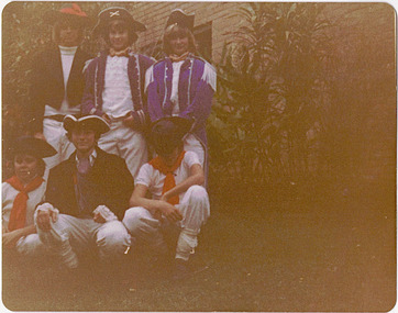 Kew Historical Society Inc
Photograph - Historic re-enactment during the Festival of Kew, 1978
At the 1978 Festival of Kew, a number of organisations, including the City of Kew, the Kew Historical Society, Trinity Boys Grammar School and local Girl Guides participated in a re-enactment of the expedition of the party of Charles Grimes in surveying the Yarra River as far as Kew in February 1803. The location for the event was Yarra Bend Park near the Studley Park Boat House. The event was organised by the Kew Historical Society. The re-enactment was captured by a number of amateur photographers as well as by a photographer from the local Progress Press.Local communities select events to commemorate according to their shared history and values. Commemorations of colonial exploration were popular with local historical groups such as the Kew Historical Society in the twentieth century. In re-enacting events such as the Grimes survey of the Yarra, students from a local school were encouraged to take on specific roles, including play-acting individuals involved in the survey party as well as members of the local Wurundjeri People. The photographs, taken by amateur and professional photographers, represent a period in time when the dominant values were those shared by the descendants of European settlers in Victoria. Original colour photographic positive of six Trinity Grammar students, dressed in costume as members of the Charles Grimes survey of the Yarra of 1803.Annotated on reverse: "TRINITY GRAMMAR BOYS DRESSED AS GRIMES' PARTY DURING RE-ENACTMENT / K.H. SOCIETY'S CONTRIBUTION TO 1978 FESTIVAL / DONATED BY M. ROLLEY"kew historical society, trinity grammar school, kew girl guides, city of kew, yarra river, charles grimes, collins expedition, wurundjeri people, yarra bend park, colonial surveys, historic re-enactments, festival of kew, kew festival -
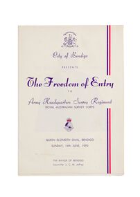 City of Greater Bendigo - Civic Collection
Ceremonial object - Invitation, City of Bendigo, The Freedom of Entry, 1970
On the 27th March, 1942 'Fortuna House' was occupied by LHQ Cartographic Company, Australian Survey Corps. Fortuna was the site of the base map plant and during this time approximately sixteen million maps of Australian Territories in the South West Pacific area were produced for use by the Allied Services. Fortuna was purchased in 1951 by the Commonwealth Government and until 1970 the Survey Corps and Regiment became part of community life in the district. This event to grant the Regiment Freedom of Entry took place at the Queen Elizabeth Oval on Sunday 14th June, 1970.Booklet outlining the celebrations commemorating the Army Survey Regiment's time in Bendigo. Includes a short history of the Regiment's association with the City which spanned from 1942 - 1970 as well as the day proceedings attended by the Mayor and Councillors.fortuna house, george lansell, royal aust survey corps, queen elizabeth oval, mayor jeffrey -
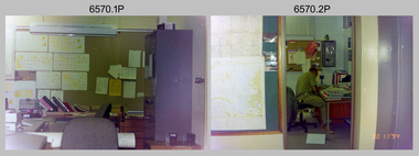 Bendigo Military Museum
Photograph - 4th Field Survey Squadron – Work Areas, Keswick Barracks, Adelaide SA, 1994
This is a set of five photographs featuring 4th Field Survey Squadron work areas at Keswick Barracks, Adelaide SA in 1994.This is a set of five photographs featuring 4th Field Survey Squadron work areas at Keswick Barracks, Adelaide South Australia, in November 1994. The colour photos are on 35mm negative film and are part of the Army Survey Regiment’s Collection. The photographs were scanned at 96 dpi. .1) - Photo, colour, 1994. Work area. .2) - Photo, colour, 1994. Unidentified Warrant Officer’s office. .3) - Photo, colour, 1994. Work area. .4) - Photo, colour, 1994. Work area. SSGT Brian Collings. .5) - Photo, colour, 1994. Office work. Unidentified soldier..1P to .5P – There are no personnel identified. royal australian survey corps, rasvy, 4 fd svy sqn -
 Bendigo Military Museum
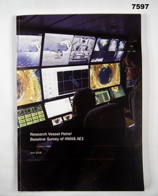
Book, Find AE1 Ltd & Australian National Maritime Museum, "RESEARCH VESSEL PETREL BASELINE SURVEY OF HMAS AE1", 2018
"Research Vessel Petrel - Baseline Survey of HMAS AE1" This book is a report of a comprehensive photographic survey completed on a c.1938 submarine wreck off the coast of PNG.Soft cover book. Cover - cardboard with white print on black and dark blue background on front and spine. Illustrated with colour photographs. Front cover - "RV Petrel control room during the survey". Back cover - "AE1 bow torpedo tube". 179 pages, cut, plain, white paper. Illustrated in black and white and colour photographs, maps and technical drawings.books, ww2, submarine, png, photographic -
 Whitehorse Historical Society Inc.
Map, Melbourne Metropolitan Area Base Map, 1957?
Sheet 254 of part of the Municipality of Nunawading and part of the Parish of Nunawading, showing roads, block numbers, creeks and contours mostly south of Canterbury Road.Sheet 254 of part of the Municipality of Nunawading and part of the Parish of Nunawading, showing roads, block numbers, creeks and contours mostly south of Canterbury Road. Prep. from State Aerial and Cadastral survey information, August 1957. Scale: 400 ft = 1 inchSheet 254 of part of the Municipality of Nunawading and part of the Parish of Nunawading, showing roads, block numbers, creeks and contours mostly south of Canterbury Road. city of nunawading, cadastral -
 Bendigo Military Museum
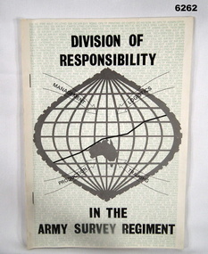
Booklet - Division of Responsibility within the Army Survey Regiment, Army Survey Regiment, 30.10.1979
Division of Responsibility within the Army Survey Regiment detailing the Management, Logistics, Production and Training in some detail. Sections detail the functions of key personnel and sub sections within the Regt. Other Sections describe production responsibilities, coordination of production aspects, management, manning and supply. Annex A has 13 x appendices. The "P" category has Personnel Employment - Officers, Other Ranks and Misc. Individual Support, Collective Support, Discipline, Financial, Conditions of Service, Ceremonial, Personnel Branch Services, Individual Training and other functions not allocated to the "P" category.A4 booklet detailing the division of responsibility within the Army Survey Regiment, paper pages with two staples on the booklet spine.royal australian survey corps, rasvy, fortuna, army survey regiment, army svy regt, asr -
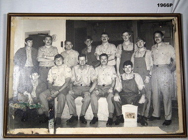
 Bendigo Military Museum
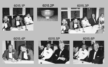
Photograph - Royal Australian Survey Corps Formal Dinner, 1966
These photographs were taken at a RASvy Corps Formal Dinner at the Army Survey Regiment in 1966. The formal dinner commemorated the 50th Year Jubilee anniversary of the Royal Australian Survey Corps’ formation. Known personnel in the photographs were Brigadier Don Macdonald AM, Director of the Survey Corps and LTCOL Frank Buckland OBE, who was the CO of the Army Survey Regiment. The 50th year Jubilee Dinner silver bowl often appeared as a centrepiece in Officer’s Mess functions.These six black and white photographs were taken at a RASvy Corps Formal Dinner at the Army Survey Regiment in 1966. The photographs were printed on photographic paper and are part of the Army Survey Regiment’s Collection. The photographs were scanned at 300 dpi. .1) Photo, black & white, L to R: BRIG Don Macdonald AM, unidentified, LTCOL Frank Buckland OBE .2) Photo, black & white, 50th year Jubilee Dinner Bowl .3) Photo, black & white, L to R: BRIG Don Macdonald AM, unidentified, LTCOL Frank Buckland OBE, unidentified .4) Photo, black & white, L to R: BRIG Don Macdonald AM, unidentified .5) Photo, black & white, L to R: LTCOL Frank Buckland OBE, unidentified .6) Photo, black & white, L to R: LTCOL Frank Buckland OBE, unidentified royal australian survey corps, rasvy, fortuna, army survey regiment, army svy regt, asr -
 Bendigo Military Museum
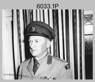
Photograph - Directors of Survey Army Headquarters, c1942-1967
This is a set of two photographs of Directors of Survey Army Headquarters circa 1942 to 1967. COL Lawrence FitzGerald OBE was Director from 1942 to 1960. He received the Order of the British Empire in 1948 for his service in WW2. Although it is not known when BRIG Lawrence FitzGerald OBE was promoted to Brigadier, it is possibly an honorary promotion on his retirement in 1960. He served in the Australian Army from 03 September 1923 to 05 January 1960. COL Lawrence FitzGerald OBE was succeeded by COL Donald Macdonald AM, whose appointment to Director was from 1960 to 1967. COL Macdonald AM was promoted to Brigadier on his retirement before assuming the honorary position of Colonel Commandant of the Royal Australian Survey Corps. He served in the Australian Army from 01 January 1936 to 22 March 1960.This is a set of two photographs of Directors of Survey Army Headquarters circa 1942 to 1967.The photographs were printed on photographic paper and are part of the Army Survey Regiment’s Collection. They were scanned at 300 dpi. .1) - Photo, black and white, c1950s. D-SVY COL Lawrence FitzGerald OBE. .2) - Photo, black and white, c1960s. D-SVY COL Don Macdonald AM, MID. .1P to .2P – no annotationsroyal australian survey corps, rasvy, army survey regiment, army svy regt, fortuna, asr -
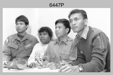 Bendigo Military Museum
Photograph - Defence Co-operation Project Students, School of Military Survey, Bonegilla, VIC, 1990
This is a photograph of Defence Co-operation Project (DCP) students from the Pacific region who attended the 1/90 Specialist Carto course held at the School of Military Survey, Bonegilla, Victoria from the 9th of May to the 5th of June 1990.This is a photograph of Defence Co-operation Project (DCP) students attending the 1/90 Specialist Carto course held at the School of Military Survey, Bonegilla, Victoria in 1990. The photograph was printed on photographic paper and is part of the Army Survey Regiment’s Collection. The photograph was scanned at 300 dpi. .1) - Photo, black & white, 1990, DCP Students L to R: SGT Ramos – Philippines, Miss Chukeni – Solomon Islands, SGT Laguador – Philippines, CPL Jais – Malaysia. .1P – Students, course title and date annotated on back of photo.royal australian survey corps, rasvy, army survey regiment, army svy regt, school of military survey, fortuna, asr -
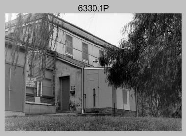 Bendigo Military Museum
Photograph - Printing Building, Lithographic Squadron - Army Survey Regiment, Fortuna, Bendigo, c1986
This is a set of ten photographs of Lithographic Squadron’s Printing Building at the Army Survey Regiment, Fortuna, Bendigo, c1986. The building was originally George Lansell’s gold crushing battery. When the Army took possession of Fortuna in 1942, it was modified with reinforced concrete floors to house the heavy-duty printing equipment. An additional building was purpose built on the eastern side of the printing building in 1987 to house a new computer-controlled Heidelberg Speedmaster five colour lithographic offset Printing Press. See item 6131.18P for photos of foundation preparation for the new building. This is a set of ten photographs of Lithographic Squadron’s Printing Building at the Army Survey Regiment, Fortuna, Bendigo, c1986. Black and white photographs are on 35mm negative film and scanned at 96 dpi. They are part of the Army Survey Regiment’s Collection. .1) to .10) - Photos, black & white, c1986. Lithographic Squadron’s Printing Building.There are no annotations with the photos. royal australian survey corps, rasvy, army survey regiment, army svy regt, fortuna, asr, litho sqn, litho -
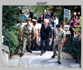 Bendigo Military Museum
Photograph - Prime Minister’s Visit to the Army Survey Regiment, Fortuna, Bendigo, 1990
This photograph of Prime Minister Hon RJ Hawke’s visit to the Army Survey Regiment was taken at Fortuna, Bendigo in March 1990. This occasion was one of several events held to commemorate the 75th anniversary of the formation of the Royal Australian Survey Corps. The one-hour visit was a rare opportunity for RA Svy to demonstrate to its Prime Minister the unit’s important role as Defence’s map production agency, its technical equipment, and its economic importance to Bendigo. It was also an opportunity to take him through historic Fortuna Villa. This occasion is covered in more detail in page 143 of Valerie Lovejoy’s book 'Mapmakers of Fortuna – A history of the Army Survey Regiment’ ISBN: 0-646-42120-4. Refer to Item 6247.30P for more photos of the Open Day. This photograph of Prime Minister Hon RJ Hawke’s visit to the Army Survey Regiment was taken at Fortuna, Bendigo in March 1990. The colour photograph was printed on photographic paper and is part of the Army Survey Regiment’s Collection. The photograph was scanned at 300 dpi. .1) - Photo, colour, 1990, Prime Minister Hon. R.J. Hawke AC GCL entering the front steps of Fortuna Villa. L to R: unidentified officer, MAJ Duncan Burns, Bob Hawke, John Brumby AO (partially obscured), CO LTCOL Rene van den Tol.There are no annotations.royal australian survey corps, rasvy, army survey regiment, army svy regt, fortuna, asr -
 Bendigo Military Museum
Photograph - Army Headquarters Survey Regiment Open Day, Fortuna, Bendigo, c1960s
This is a set of three photographs of an Open Day held at the Army Headquarters Survey Regiment, Fortuna Villa, Bendigo, circa 1960s. Although most of the photos were taken outdoors, a technical tour may have been conducted through the production areas of the unit. It is likely the band performing next to Fortuna’s lake in photo .3P was the 3rd Military District Band.This is a set of three photographs of an Open Day held at the Army Headquarters Survey Regiment, Bendigo c1960s. The photographs were printed on photographic paper and are part of the Army Survey Regiment’s Collection. They were scanned at 300 dpi. .1) & .2) - Photo, black and white, 1960s. Unidentified civilian visitors. .3) - Photo, black and white, 1960s. The 3rd Military District Band, unidentified civilian visitors..1P to .3P – no annotationsroyal australian survey corps, rasvy, army survey regiment, army svy regt, fortuna, asr -
 Bendigo Military Museum
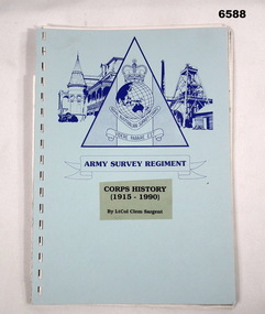
Booklet - Royal Australian Survey Corps Corps History 1915 - 1990 - Lt Col Clem Sargent, LtCol Clem Sargent, 1990
This 31 x page booklet titled "Corps History (1915 - 1990)" was written by LtCol Clem Sargent who was the Colonel Commandant of the Royal Australian Survey Corps at the time. The Colonel Commandant was an honorary appointment charged with preserving the History of the Corps. LtCol Sargent served in the Survey Corps from 1945 till 1975 and retired at the rank of Colonel.31 x page booklet with blue card covers and black plastic binding containing text and some black and white poor-quality photos. Cover has Army Survey Regiment logo printed in blue and title "Corps History (1915 - 1990) By LtCol Clem Sargent"royal australian survey corps, rasvy, fortuna, army survey regiment, army svy regt -
 Melbourne Legacy
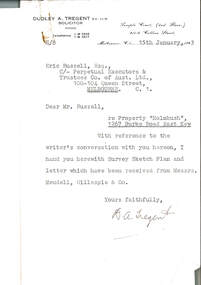
Document, re Property "Holmbush", 1267 Burke Road East Kew, 1943
Formal identification of the property to be bought as the first Melbourne Legacy residence sent to Legatee E. Russell, Chair of the Hostel Committee. The survey is hand drawn and meticulously measured.The documents demonstrate business practices in the 1940s with regard to the purchase of property, as well as being an important record of the first property to be purchased by Melbourne Legacy as a residence for children.00310.1 Letter from Dudley A. Tregent, Solicitor, dated 15 January 1943, to Legatee E. Russell, Chair of the Hostel Committee, enclosing the survey sketch plan. White paper, black letterhead and typing, two holes punched for filing 00310.2 Survey sketch plan by Meudell, Gillespie & Co, dated 13 January 1943. Black type and printing, with some red shading and writing, on white foolscap paper. 00310.3 Letter from Meudell, Gillespie & Co to Mr. D.A. Tregent, Solicitor. Quarto, black typing, red underlining, on white.00310.1 Signed by D.A. Tregent 00310.2 Signed by Percival A. Jordan 00310.3 Signed by Percival A. Jordanholmbush initial negotiations, properties, holmbush -
 Bendigo Military Museum
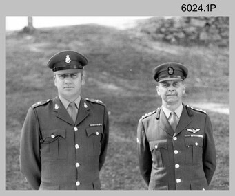
Photograph - Commander 3MD Visit to the Army Survey Regiment, 1982
These photographs were most likely taken in 1982 during the Commander 3rd Military District - BRIG Geoffrey Cohen AM visit to the Army Survey Regiment, Fortuna, Bendigo. As there are no annotations on the photos, the name of the RSM is unknown. BRIG Geoffrey Cohen AM, LTCOL Peter Eddy and WO1 Aub Harvey are positively identified. This is a set of three photographs taken on the occasion of an Australian Army General’s visit to the Army Survey Regiment, Bendigo. The photographs were printed on photographic paper and are part of the Army Survey Regiment’s Collection. The photographs were scanned at 300 dpi. .1) and .2) Photo, black & white, 1982. L to R: Army Svy Regt’s This is a set of three photographs taken on the occasion of the Commander of the 3rd Military District’s visit to the Army Survey Regiment, Bendigo. The photographs were printed on photographic paper and are part of the Army Survey Regiment’s Collection. The photographs were scanned at 300 dpi. .1) and .2) Photo, black & white, 1982. L to R: Army Svy Regt’s CO - LTCOL Peter Eddy and Commander 3MD BRIG Geoffrey Cohen AM. .3) Photo, black & white, 1982. L to R: Army Svy Regt’s RSM - WO1 Aub Harvey and an unknown RSM. .1 to.3 - no annotationsroyal australian survey corps, rasvy, army survey regiment, army svy regt, fortuna, asr -
 Federation University Historical Collection
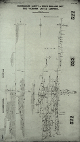
Plan, Underground Survey of Mines, Ballarat East. The Victoria United Company, 1903
Underground Survey of The Victoria United Company from Geological Survey of Victoria, Memoirs No. 4.ballarat east, victoria united company, cgt, mining, geological survey, longitudinal section -
University of Melbourne, Burnley Campus Archives
Document, 1979 - 81 Triennial Survey, 1978
TAFEC Triennial Survey, Dept. of Agriculture Triennial Surveys for TAFE and CAE courses. 3tafec, triennal survey, tafe, courses, department of agriculture -
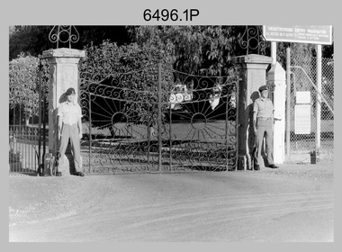 Bendigo Military Museum
Photograph - Army Survey Regiment – Front Gate Guard, Fortuna Villa, Bendigo, c1982
This is a set of four photographs of a front gate guard at the Army Survey Regiment, Bendigo circa 1982. The guard was appointed on a pay day. A Defence decision for a pay rise resulted in a considerable amount of back-dated salary renumerated to members of the unit.This is a set of four photographs of a front gate guard at the Army Survey Regiment, Bendigo circa 1982. The black & white photographs are on 35mm negative film and are part of the Army Survey Regiment’s Collection. The photographs were scanned at 96 dpi. .1) & .2) - Photo, black & white, c1982. L to R: SPR Wayne Lloyd, SPR Steve Linane. .3) - Photo, black & white, c1982. SPR Wayne Lloyd. .4) - Photo, black & white, c1982. SPR Steve Linane..1P to .4P – No personnel are identified. Annotate on film negative sleeve ‘Back Pay Guard’.royal australian survey corps, rasvy, army survey regiment, army svy regt, fortuna, asr -
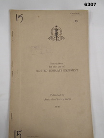 Bendigo Military Museum
Manual - Australian Survey Corps 1947 - Instructions for the use of Slotted Template Equipment, Australian Survey Corps, 1947
This is an instruction manual describing in detail the construction of the templates used for producing map compilation sheets from aerial photographs, and how the system works.Foolscap size, soft carboard covers, 9 x numbered pages, 3 x fold out pages containing two photos on each. Australian Survey Corps Badge on cover. Stapled and re-stapled on Left hand edge.Front Cover, "15" Top Left and Bottom Left corner, "COOPER" and stamped "58" in Top Right, "AHQ/Misc/0015" Bottom Left Corner, Stamped "Eastern Command Survey Service copy 5"royal australian survey corps, rasvy, fortuna, army survey regiment, army svy regt, asr -
 Kiewa Valley Historical Society
Photographs and copies of photographs of the pack horses and early horsemen who transported supplies to outposts in the Bogong High Plains, via cattle tracks before access roads were made
In the mid to late 1930’s survey outposts were established to plot the early stages of the Kiewa Hydro Electric System for the SECV in the Bogong High Plains. Before any roads were built, the old cattleman’s tracks were used with packhorses to deliver supplies, wages and mail and collect timesheets and correspondence from the workmen and dam builders living in canvas tents and at the outlying survey posts. The trip up the mountain was long and hard and dangerous for both horse and man Most of the men of the survey teams were not bush-men and were often ill equipped for the harsh weather and living conditions of bush camping, often arriving in their city clothes ready for work. The tent city at Bogong was destroyed by bush fires in 1939 after which an access road was built from Mt Beauty to transport building materials for more permanent dwellings for workmen. Pack horses continued to be used for transporting goods etc. to workers further up the mountain.Without the work of horsemen and their pack horses providing supplies and communications for outlying outposts, surveying and early planning for the Kiewa Valley Hydro Electric scheme could not have gone ahead and the dams and power stations which support the system could not have been constructed. The Hydro-electric scheme, and the workers who planned and built it play a major part in the early history of the Kiewa Valley and many original families still remain living, or have ties with the local area.: Set of 21 black and white photographs and copies of photographs depicting the pack horses and the men who handled them, transporting supplies and correspondence to the outlying camps and survey posts in the Bogong High Plains, via the rough cattlemen’s tracks. Photographs also show the early tent camps of the workers. Some photos mounted on A4 white paper. Some photos enlarged to A3 poster size for display1. Handwritten on back – Max Lawrence 2. -8 No inscriptions 9. Handwritten on back- Packing in supplies for early workers of the Kiewa Hydro scheme. There were no roads in the early days of the scheme 10. Printed on bottom of photo- Roper’s cattle on road below Howman’s Gap 11. Handwritten on back – Roper’s et al about to leave for the high plains 12. Printed under photo- Syd Ryder at the Pretty Valley Cut-Out (JBR) 13-16. No markings 17. Printed under photo- Gwen Talbot visits the Camp area. 1937 18. Handwritten on back- 14/1 Barbara Talbot 19. No markings 20-21. No markings 22. Printed under photo- STATE ELECTRICITY COMMISSION OF VICTORIA. Date: 15-3-45 Time: 8.0pm No: K 1838 Kiewa Hydro-Electric Works, Investigations 1944-1945 – Survey Camp at Young’s Hut pack horses; bogong high plains; survey posts; supplies delivery -
 Bendigo Historical Society Inc.
Map - STRUGNELL COLLECTION: UNITED HUSTLER'S & REDAN MINE, September 1913
Map, United Hustler's & Redan Mine, Transverse Section, Hustler's Line of Reefs, Bendigo. Plate No. XX1X (29).Bulletin No 33 Signed H.A.Whitelaw. Drawing shows the vertical shaft descending to over 1805 feet and appears to show samples of connecting horizontal shafts with their respective mineral contents. One level shows respective water levels .Underground Survey Officemap, bendigo, hustler's & redan mine -
 Bendigo Historical Society Inc.
Map - STRUGNELL COLLECTION: UNITED HUSTLER'S & REDAN & K.K.MINES, September 1913
Map, Hustler's Line of Reefs, United Hustler's & Redan & K.K.Mines, Bendigo. Plate No. XXV111 (28),Bulletin 33.Signed H.A.Whitelaw. Drawing seems with their respective mineral contentsUnderground Survey Officemap, bendigo, united hustler's, redan, k.k.mines -
Moorabbin Air Museum
Newspaper (item) - Aviation 1970 - A Survey by The Australian Tuesday March 3 1970
A survey by Stanley Brogden -
 Bendigo Historical Society Inc.
Document - LANDS OFFICE : TANDARRA ESTATE, COUNTY OF BENDIGO, 1906 - 1920
Document: green bound hard cover journal with red spine binding and corners. On spine ' Tandarra' written in black. Journal contains details of allotments leased in the Tandarra Estate. Maps and letters relating to blocks are enclosed. LH page: details of lessee, improvements (year range 1906 - 1920) , RH page: residence, population, results of cultivation, stock etc., remarks re lessee's gains or losses each year.Land and Survey Officerland leases, tandarra, bendigo, sandhurst, lands office, land settlement -
Bendigo Historical Society Inc.
Map - PARISH OF SANDHURST 1961, 1961
BHS CollectionAt Bendigo Parish of Sandhurst. Sheet F.Dept of Lands and Surveybendigo, land sales, parish map