Showing 1233 items matching "the gap"
-
 Bendigo Historical Society Inc.
Document - AULSEBROOK COLLECTION: BENDIGO AND DISTRICT TOURIST ASSOCIATION MINUTES
Aulsebrook Collection: Bendigo and District Tourist Association Meeting Minutes. -Fools gap size loose notes for Meeting held on June 2nd (no year stated). - (3490.44b) Two pages on minutes -(3490.44a) 9 extensive pages of a draft for Brochure on Bendigo Diggings project (mentioned in minutes) -
 Halls Gap & Grampians Historical Society
Photograph - B/W, C 1871
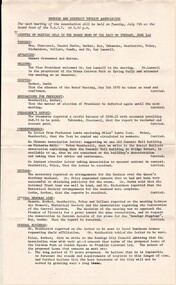
Jan 3rd, "This history of Rose's Gap police station is sketchy and rather short despite the fact that the lock up was built in 1860. The police station was closed in 1863. During its six years of operation, eleven mounted police were reported to have been stationed there" extract from Victoria's Wonderland: a Grampians history - Ch Roes Gap and Troopers Ck. Photo shows road past remains of police station Man sitting on fence rail at left of picture. Rocks on right side of photo. Opposite present Troopers Creek camping areaaccess routes, roads, buildings, police station -
 Halls Gap & Grampians Historical Society
Photograph - B/W, C 1880s
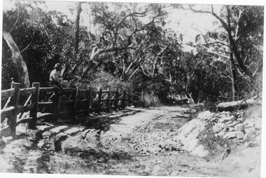
This photo is of the road approaching Delley's Bridge. It shows methods of transport and the access route to Halls Gap in the late 19th Century.A man with a walking stick walking away from the camera on a rutted dirt road through trees and bush. Another man is approaching from the opposite direction on horseback.access routes, roads -
 Halls Gap & Grampians Historical Society
Photograph - Coloured, C Oct 1985
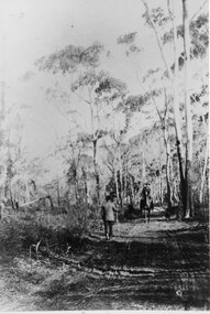
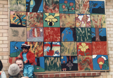
The photo is of a mural displayed at the wildflower show in 1985. It would have been made by the local Halls Gap school children.The photo is of a large, colourful mural consisting of five rows and six columns of different panels, attached to a brick wall. There is a young boy standing in front of the mural.events, wildflower show -
 Halls Gap & Grampians Historical Society
Photograph - Coloured, C Oct 1985
The photo is of a mural displayed at the wildflower show in 1985. It would have been made by the local Halls Gap school children.The photo is of a large, colourful mural consisting of five rows and six columns of different panels, attached to a brick wall. There is a a man with a young child sitting on his shoulder and two other people (one with back to camera) in the lower left corner.events, wildflower show -
 Halls Gap & Grampians Historical Society
Photograph - B/W, C 1900s
This is a photo of a woodchopping competition, a popular event at this time. The location is unknown, but it may have been the recreation area in Halls Gap.The photo shows men standing behind wood-chop blocks. One of the men is holding a starter's pistol, one is holding an axe and one is holding a book. There is a man seated on one of the blocks, In the left foreground three men are seated with their backs to the camera. Spectators can be seen in the background behind a wire fence.recreation, woodchopping competition -
Halls Gap & Grampians Historical Society
Photograph - B/W, C 1900s
This is a photo of a woodchopping competition, a popular event at this time. The location is unknown, but it may have been the recreation area in Halls Gap.This is an oval photo (printed on rectangular paper). The photo shows ten men standing on wood blocks, axes in hand, waiting to commence the event. There is a man standing on the right with a paper in one hand and the other hand on his hip. All are looking towards the camera. Spectators can be seen behind a wire fence in the background.recreation, woodchopping competition -
Halls Gap & Grampians Historical Society
Photograph - B/W, C 1900s
This is a photo of a woodchopping competition, a popular event at this time. The location is unknown, but it may have been the recreation area in Halls Gap.The photo shows five men standing on wood-chop blocks, all with axes in hand. In the foreground is a man sitting on the ground and discarded blocks, some numbered. Spectators can be seen in the background behind a wire fence.recreation, woodchopping competition -
 Halls Gap & Grampians Historical Society
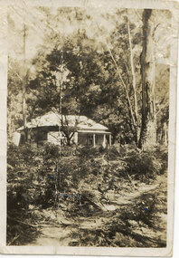
Photograph - Sepia, C 1876
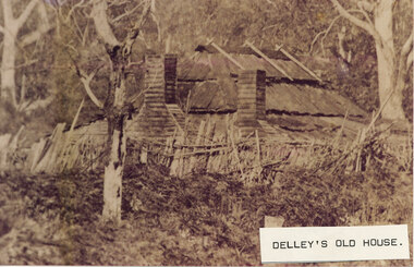
This is a photo of Delley's house. For further information see "Bridging The Gap" p13-14,17,22,54. This photo is an enlargement of a portion of Record 531.Photo shows old house. The roof is constructed of wooden slats held down by pieces of what appears to be fluming. There are two chimneys and the lower half of the house is obscured by a stick fence and undergrowth. There is a large tree in the foreground and another in the far right background. The house is surrounded by bush.buildings, houses -
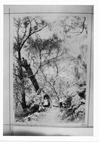
 Halls Gap & Grampians Historical Society
Photograph - B/W
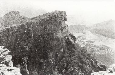
Relph Peak, named after A.U. Relph of the Government Tourist Department. See P67 of Bridging the Gap, by Ida Stanton. Steep rocky escarpment, valley down below, smaller range opposite, mountain rising higher in background.scenery, wonderland range -
 Stawell Historical Society Inc
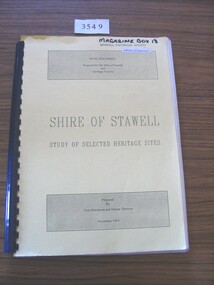
Book, Tom Hutchison & Denise Thorson, Shire of Stawell - Study of Selected Heritage Sites, 1994
This report is a re-evaluation of the Historical Survey: Shire of Stawell as undertaken by the Stawell and Halls Gap Historical Societies in June 1990.Yellow Card cover with black print and black plastic bindingFinal Document Prepared for the Shire of Stawell and Heritage Victoria Shire of Stawell Study of Selected Heritage Sites Prepared by Tom Hutchison and Denise Thornson November 1994stawell heritage -
 Falls Creek Historical Society
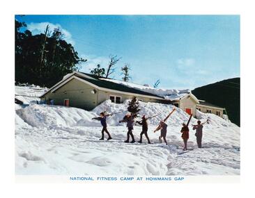
Postcard - National Fitness Camp at Howman's Gap
These photographs were taken in and around Falls Creek by Samuel Keith Pearce and printed for him as a foldout postcard by NuColor Vue. The postcards state they were printed for S. K. Pearce Pty. Ltd of Tawonga and Mount Beauty. Samuel Keith Pearce was born on 24 June 1917 in Armadale, Victoria. By the late 1940s he owned the Mt Beauty Supermarket, Newsagency, Drapery and Hardware store at Mount Beauty and also a store at Tawonga in partnership with his brother Gordon Cathew Pearce. For some time, they operated as Pearce Brothers. In the early 1960s Keith also opened a mini mart In Falls Creek. As well as being a keen photographer and an astute businessman, Keith Pearce was a well-known identity in the Kiewa Valley, making many contributions to the development of the area over a long period. This included serving as a member of the Bright Shire Council for many years. He worked hard to promote the interests of the Upper Kiewa Valley. As a sign of recognition and appreciation for his contribution to the community, the park opposite the grocery store in Mount Beauty was named the SK Pearce Gardens in his honour. Samuel Keith Pearce died on 7 July 1994 in Mount Beauty, VictoriaThis collection of postcards and image is significant because they were commissioned by a highly successful business in Falls Creek, Victoria.A high definition photo of the skiers walking in front of the National Fitness Camp at Howmans Gap. The Camp was run by the Victorian State National Fitness Council. Initially the camp was leased from the State Electricity Commission (SEC). It had a capacity of 110 participants and offered both summer and winter activities.falls creek resort, national fitness camp howmans gap -
 Halls Gap & Grampians Historical Society
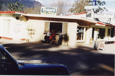
Photograph - Coloured, C 1960
This is a photo of Thomson's General Store; a second general store built in Halls Gap by Jack and Clarrie Thomson . They incorporated a cafe with their business.Photo shows five children are standing in front of the window of a general store. There is a dark coloured "E" series Holden car parked in the left front foreground.buildings, shops -
 Halls Gap & Grampians Historical Society
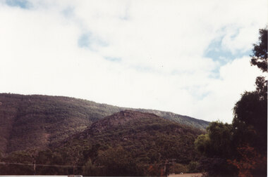
Photograph - Coloured
This is a photo of Maggie's Peak, where Chautauqua picnics were held. This peak overlooked the are in Halls Gap where the concerts were held.A photo of a small peak with a rocky cliff near the summit and a larger hill rising behind. There is a edge of a large tree visible in the right foreground.scenery, grampians ranges -
 Halls Gap & Grampians Historical Society
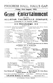
Flyer - B/W, C mid-1913
The entertainment was to occur on 22/08/1913 at the Progress Hall in Hall's Gap. The flyer includes a programme and advises of a Grand Ball to follow.This is a Flyer advertising "Grand Entertainment by the All-Star Vaudeville Comany" to be held on Friday, 22 August, 1913.media, flyers, media, programmes -
 Halls Gap & Grampians Historical Society
Photograph - Sepia, C 1930s - 1940s (?)
The cottage is typical of the holiday houses that could be rented in Halls Gap. This house was called "The Wattles" and was one of the houses used as "Girls Hut".The photo shows a weatherboard cottage set in bush. A sandy path through bracken can be seen in the foreground. There is a tall gum tree in the right of the photo."The Wattles" written in pen on rear.buildings, houses -
 Halls Gap & Grampians Historical Society
Photograph - B/W, C 1987
Ararat pipe band member taking part in the street parade held before the opening of the 1987 Halls Gap Flower Show.The photo is a close-up of a young woman in "Scottish dress" playing the bagpipes. The photo is taken from a position beside and slightly behind the woman."1987 (1) H.G.F.S." written in ink on back.events, wildflower show -
 Halls Gap & Grampians Historical Society
Photograph, C 1960s
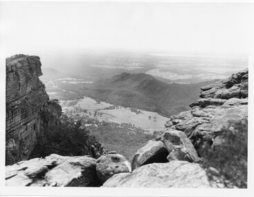
The valley is known as Fyans Valley and the township of Halls Gap. Photo is typical of those taken by the Forestry Commission (Vic) during the 1960s.Photo shows two rocky outcrops in the foreground framing a valley in the distance below. A partial view of a mountain range flanks the valley. Plains of trees and open fields, and also a lake, can be seen beyond the mountain range. Within the valley in the middle of the photo buildings, roads and cleared land can be seen.scenery, fyans valley -
 Stawell Historical Society Inc
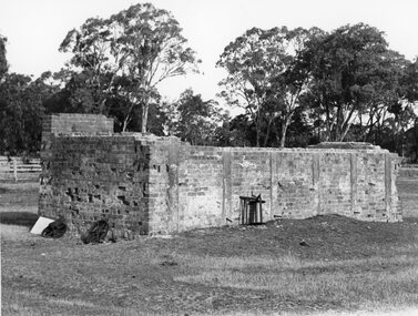
Photograph, Brick remains of the Tannery of Mr C Whel off Halls Gap Road Stawell West behind the London Hotel 1982
Brick remains of Tannery run by C Whel off Halls Gap Road Stawell West behind the London Hotel 1982stawell industry -
 Stawell Historical Society Inc
Photograph, Brick remains of the Tannery of Mr C Whel off Halls Gap Road Stawell West behind the London Hotel 1982
Brick remains of Tannery run by C Whel off Halls Gap Road Stawell West behind the London Hotel 1982stawell industry -
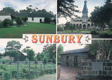 Sunbury Family History and Heritage Society Inc.
Postcard, John Munns, Sunbury, C1980s
The four sites featured on the postcard are: Top row L-R Emu Bottom Homestead and Rupertswood Mansion. Bottom row L-R Goonawarra Vineyard and Aitkens Gap Gaol. George Evans built Emu Bottom and William Clarke was the first owner of Rupertswood. Goonwarra was one of Sunbury's early vineyards and the gaol was relocated on the police station from its original site at The Gap village on the Calder Highway.The four sites featured are important historic places in SunburyA coloured postcard featuring four historic sites in Sunbury. The word 'SUNBURY' is printed in orange across the centre of the card. Details of the four sites, the photographer and the postcard company are on the back.emu bottom, rupertswood mansion, goonawarra winery, aitkens gap gaol, george evans, william j.t. clarke -
 Bendigo Historical Society Inc.
Document - AULSEBROOK COLLECTION: LETTER FROM CIVIL DEFENCE COMMITTEE
Aulsebrook Collection: Letter from Civil Defence Committee: Bendigo Victoria. Fools Gap size, paper. Typed. 2 pages. A basic letter addressed Dear Sir, refering to the need for citizens to be ready to be air raid wardens when called. Second page has a list of equipment to use. -
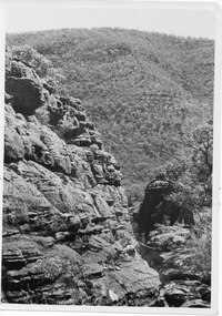 Halls Gap & Grampians Historical Society
Photograph - B/W
The area is known as The Grand Canyon on t The Pinnacle track. Photo is typical of tourism photos taken by the Victorian Railways during this period. c1950 -60'sshows a rocky escarpment on the left with a range covered with trees in the backgroundPrinted on back: Copyright Photograph. This photograph may be reproduced on condition that it is acknowledged as 'VICTORIAN RAILWAYS PHOTOGRAPH'. P3484 Written in pencil. The Grand Canyon Halls Gap written in blue penscenery, wonderland range -
 Halls Gap & Grampians Historical Society
Photograph - B/W, C 1898
The picture shows Maggie Galbraith and five small children (identities unknown) beside a jinker track (bridal path) near Halls Gap.A woman and five small children, two boys and three girls, on a dirt track with trees and rocks on either side of it.access routes, jinker track, people, galbraith -
 Halls Gap & Grampians Historical Society
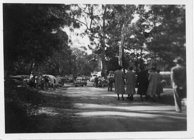
Photograph - B/W, C 1950
Halls Gap Grampians Camping reserve on Flower Show Day in 1950. This is the main road looking towards the stores from Grampian House.The photo shows a road with trees growing on either side. There are cars parked on either side of the road and people standing and walking along the road. In the centre there are two cars driving along the road towards the camera.events, wildflower show -
 Halls Gap & Grampians Historical Society
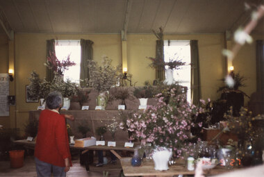
Photograph - Coloured, 27/09/1985
This is a photo of Ida Stanton taken while setting up for the Wildflower Show in Halls Gap Hall. The show opened on 28/09/1985.Photo shows a woman wearing a red cardigan with her back to the camera. She is looking at a display of wildflowers in vases, set up on shelves and a trestle table. There are two windows in the background.events, wildflower show -
 Stawell Historical Society Inc
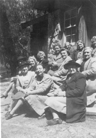
Photograph, Baptist Church members at a Picnic c.1930s - 2 photos plus earlier photo
Baptist Church members Picnic Groups (3 photos) Probably Halls Gap. Group probably beside Baptist Church c. 1900sThree black & white photos depicting groups of people. Two are the same and one of older period. One photo is of 12 women seated in front of a stone building. The earlier photo in a circular frame is of 9 people in a group in front of a brick building.stawell -
 Stawell Historical Society Inc
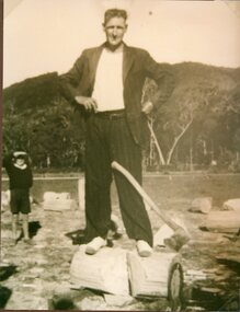
Photograph, Mr Michael E Martin, a woodcutter, at Halls Gap Wood Chop c1943
Michael Ernest Martin at Halls Gap Wood Chop c1943. Mr Martin was a Woodcutter one of many who supplied the Woollen Millsstawell deep lead -
 Sunbury Family History and Heritage Society Inc.
Photograph, Rosa McCall, Anderson Road, Sunbury, February 2014
The street in the photograph is Anderson Road, taken from the Darbyshire Street end and looking towards the SE to Gap Road. It was taken in February 2014. A non-digital coloured photograph of a street with a two storey house and three single storey homes.anderson road, sunbury, darbyshire road -
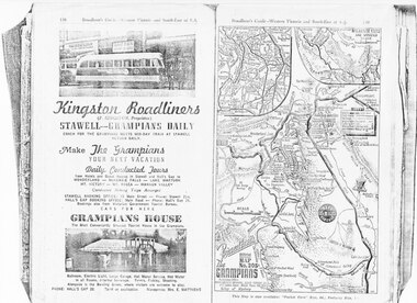 Halls Gap & Grampians Historical Society
Magazine - Photocopy
Kingston Roadliners (F. Kingston, Proprietor) STAWELL - GRAMPIANS DAILY Coach for the Grampians meets mid day train at Stawell Return Daily Make the Grampians your next vacation Daily Conducted Tours, from Hotels and Guesthouses in Stawell and Hall's Gap to WONDERLAND - MCKENZIE FALLS - LAKE WARTOOK - MT. VICTORY - MT ROSEA - WANNON VALLEY conducted Hiking Trips Arranged Stawell booking office: 75 Main Street - Phone: Stawell 214, Hall's Gap booking office: Main Road - Phone: Hall's Gap 35, Bookings also from Vitorian Government Tourist Bureau, Cars for hire GRAMPIANS HOUSE The Most Conveniently Situated Tourist House in the Grampians. Ballroom, electric light, large garage, hot water service, hot water in all rooms, internal sewerage. Tennis, fishing, shooting, Alongside is the Bowling Green, where visitors are welcome to play. Phone: Hall's Gap 28. Tariff on application. Manageress: Mrs, E. MatthewsAdvertisement for Kingston Roadliners, Grampians House and Map of the GrampiansAdvertisement in Broadbents, Guide of western Victoria, and South-East of S.A.media, advertisements, grampian house