Showing 10926 items
matching the land
-
 Tatura Irrigation & Wartime Camps Museum
Book, Land of the Southern Cross, 1955-56
... Land of the Southern Cross ...Produced to publicise Australia at the time of Olympic Games, Melbourne, 1956Blue background with stars of Sourthern Cross in gold with representatives of Australian emblem on front inside cover and fly leaf and on corresponding back, the kiala and lyrebirdcommonwealth of australia, olympic games, new guinea, sport -
Lakes Entrance Historical Society
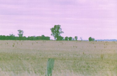
Book, A Study of Land in the Catchment of the Gippslnd Lakes Vol 1, 1988
... A Study of Land in the Catchment of the Gippslnd Lakes Vol ...108 printed pages in report, wire spiral boundBlue cardboard cover with title printed in golddocuments, reports -
Koorie Heritage Trust
Book, Barlow, Alex et al, You and me living together : the story of Aboriginal land rights, 2001
... You and me living together : the story of Aboriginal land ...Aboriginal land rights then and now. Traditional Aboriginal concepts of land and caring for land, and how European settlers ovetook the land, using it for their own purposes and changing it forever. Learn about the land wars that occurred, the years on the reserves and missions and the struggle of Aboriginal people to reclaim their lands. In this book, the story of Aboriginal land rights, then and now, is told. Read about traditional Aboriginal concepts of land and caring for land, and how European settlers overtook the land, using it for their own purposes and changing it forever. Learn about the land wars that occurred, the years on the reserves and missions and the struggle of Aboriginal people to reclaim their lands. -- Back cover.32 p. : ill. (some col.), map, ports. ; 28 cm.Aboriginal land rights then and now. Traditional Aboriginal concepts of land and caring for land, and how European settlers ovetook the land, using it for their own purposes and changing it forever. Learn about the land wars that occurred, the years on the reserves and missions and the struggle of Aboriginal people to reclaim their lands. In this book, the story of Aboriginal land rights, then and now, is told. Read about traditional Aboriginal concepts of land and caring for land, and how European settlers overtook the land, using it for their own purposes and changing it forever. Learn about the land wars that occurred, the years on the reserves and missions and the struggle of Aboriginal people to reclaim their lands. -- Back cover.aboriginal australians -- history -- juvenile literature. | aboriginal australians -- land tenure -- juvenile literature. -
Koorie Heritage Trust
Document - Printed Sheets, Bryant, Jenny, The Framlingham Aboriginal trust: Land rights before housing, 1981
... The Framlingham Aboriginal trust: Land rights before ...This report is for limited circulation to members of the Framlingham Community.Pp.43; tables; appendices; bibliography; This report is for limited circulation to members of the Framlingham Community.framlingham aboriginal trust-history, aborigines welfare board-assimilation policy-framlingham, land rights-framlingham, conditions-framlingham-1979., housing-framlingham-1979. -
Koorie Heritage Trust
Book, Blake, Les, Land of the Lowan : 100 years in Nhill & West Wimmera, 1976
... Land of the Lowan : 100 years in Nhill & West Wimmera. ...[vii], 268 p., [14] leaves of plates ; 23 cm.1. local history -- nhill -- wimmera. -
 Department of Health and Human Services
Photograph, Ararat Mental Hospital - Early landscape & farm land surrounding the main buildings of Ararat Mental Hospital "Aradale" - Black & White Photo
... surrounding the main buildings of Ararat Mental Hospital "Aradale ... -
University of Melbourne, Burnley Campus Archives
Article, Ruth Beilin, From Soil Conservation to Land Husbandry the Midwife Effect: the Australian Landcare Landscape, c.1999
... From Soil Conservation to Land Husbandry the Midwife Effect ...soil conservation, land husbandry, landcare, ruth beilin, senior lecturer -
Lakes Entrance Historical Society
Book, South Gippsland Development League, Land of the lyrebird, 1966
... Land of the lyrebird ...A story of early settlement in the great forest of South Gippsland including fauna hardships experienced by the early explorers and settlers and the settling and development of this once hostile and impenetrable part of Victoria. IllustratedRuth Clarkexplorers, settlers, fauna -
Lakes Entrance Historical Society
Book, Hollole, H.N, Land of the '' Boong', 1944
... Land of the '' Boong' ...30 sketches of Papua, drawn during the artist's duty with the Australian Forces in Papua-New Guinea 1942-44world war 1939 - 1945 -
 Sunbury Family History and Heritage Society Inc.
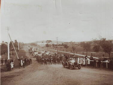
Photograph, A parade
The parade took place in Sunbury in 1919 and was held to welcome home the local returned soldiers, who had enlisted in World War 1. In the photograph the parade is approaching the intersection at Evans and Macedon Streets. Sunbury's Shopping complex now occupies the vacant land in the background, although for many years that land was the main sports ground. The building in the distance was the Sunbury Fire Brigade.Many Sunbury men enlisted to fight in World War 1. Sadly some did not return home but others did.A copy of a non-digital sepia photograph of a parade being led along a road by a vintage car. There is open land with a few buildings in the distance. Spectators are watching the parade on either side of the roadway.evans street, macedon street, world war 1., parades, welcome home receptions -
 Ringwood and District Historical Society
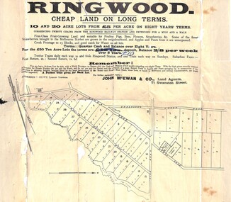
Flyer, Land Sale Advertisement, Ringwood, Victoria - 1894
Land sale advertisement for 10 and 20 acre lots from £5 per acre on eight years' terms in Ringwood, with description of local facilities and agricultural features.Subdivision map includes Mullum Mullum Road, Wonga Road, Oban Road and Anderson's Creek Road (later Warrandyte Road). Markings on reverse side indicate the sheet was sent by post from John McEwan & Co., Auctioneers, Land Agents & Business Brokers, 71 Swanston Street, Melbourne, to Mr Allan, Builder, Ringwood, postmarked in JE (June), 1894. -
Whitehorse Historical Society Inc.
Article, Historic building reduced to rubble, 1988
An old homestead which belonged to the Mullens family for 5 generations.An old homestead which belonged to the Mullens family for 5 generations has been demolished by the Board of Works who now own the land. the Board demolished the house because it was a fire hazard.An old homestead which belonged to the Mullens family for 5 generations.burwood highway, vermont south, springvale road, vermont south, mullens, hugh, mullens, mary, mullens, elma, ellerton, andrew, tate, sherryn, melbourne and metropolitan board of works -
 Kiewa Valley Historical Society
Maps - Tawonga and Feathertop
Plan of Tawonga showing roads etc, rivers, use of land in 1968 and of Feathertop in 1969.Historical use of land in Tawonga and Feathertop.1. Topographical Map - Tawonga 803 Forests Commission of Victoria 1968. Cream paper with black print. Legend: Roads, tracks etc, rivers, Parishes and use of land. 2. Feathertop 813. 1969tawonga map 1968, tawonga parishes, feathertop map 1969 -
Whitehorse Historical Society Inc.
Document, Charles Edgerton, 1851 - 1908
Life history of Charles Edgerton.Life history of Charles Edgerton who purchased land in Edgerton Road, Mitcham from Carl Benno Schwerkolt in 1892 and an account of the 1905 bushfire in the area. Prepared by Anne Jones.Life history of Charles Edgerton.edgerton, charles, schwerkolt, carl benno, edgerton road, mitcham, jones, anne -
 Whitehorse Historical Society Inc.
Document - Land Title, Land purchase, 31/07/1858
Record of land purchase by Louis Laurence Smith dated 31 July 1858. The land is adjacent to Dandenong Creek. Records of the transfer of the land in June 1895 are included. Photocopies.dandenong creek, smith, l l dr, william, gallien, jacque jean, speary, catherine, langdon, harry joseph, foster, john, youngman, edward, simmons, morris, mayfield, william george, marion, land sales -
 Greensborough Historical Society
Folder of documents, Nepean Street - fact or fiction?, by Peter Simmenauer, 2018_09
Record of ownership of 216 Nepean Street Greensborough 1916-1997, Grace Park areaPhotocopies of four Certificates of Title and other land documents, with summary of land ownership 1916-1997nepean street greensborough, grace park -
 Bendigo Historical Society Inc.
Photograph - NORM GILLIES COLLECTION: SITE OF GILLIES FAMILY FARM
Coloured photograph of open farm land rear note: Gillies Family farmed land on this property -
 Whitehorse Historical Society Inc.
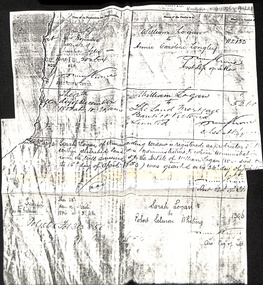
Document - Land Title, Land Transfers, 30/11/1884
Photocopy of records of land transfers of land belonging to William Logan dating from 1882 to 1884logan, william, longley, annie caroline, sarah, whiting, robert salmon -
 Ringwood and District Historical Society
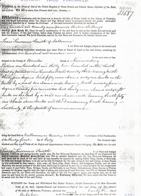
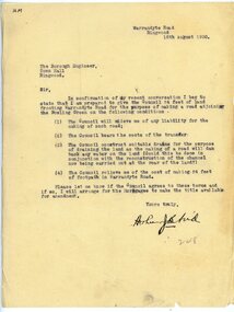
Letter, To Borough Engineer from Arthur Blood confirming gift of land adjoining Bowling Green for road-making purposes
1929 saw the establishment of the Ringwood Bowls Club initially located on the land now occupied by the Eastland Shopping Centre. It moved to its current location in Loughnan Road, Ringwood in 1997.Typed letter to Ringwood Borough Engineer from Arthur Blood confirming gift of land adjoining Bowling Green for road-making purposes. Dated 10th August 1930.city of ringwood bowls club, ringwood bowling club, ringwood bowls club, lawn bowls, bowling -
Whitehorse Historical Society Inc.
Article, Death of 'Strathdon' donor, 19/05/1971 12:00:00 AM
Article in Nunawading Gazette 19 may 1971.Article in Nunawading Gazette 19 may 1971 on the death of Mrs Mary Matheson who helped in the foundation of Blackburn, Vermont and Mitcham Presbyterian churches and donated the land for the Strathdon Homes for the Aged.Article in Nunawading Gazette 19 may 1971. matheson, mary, strathdon community, blackburn presbyterian church, vermont presbyterian church, mitcham presbyterian church -
 Bacchus Marsh & District Historical Society
Map, Bacchus Marsh Suburban Allotments Parwan Road Lodge & Dunn's Paddocks 1888
This map was created as a plan for an auction of land close to the Bacchus Marsh Railway Station. The auction took place on 23 October 1888. 102 allotments of land from an area known as Lodge and Dunn's paddocks was offered for sale. A single page paper map showing allotments of land for sale along the Parwan Road in Maddingley. The map is pasted into a bound volume containing 76 maps or plans in total. High resolution digital image stored on BMDHS computer network. land sales bacchus marsh, land sales maddingley, bacchus marsh victoria maps, maddingley victoria maps -
 Hume City Civic Collection
Photograph, c late 1980s
The series of photographs show a number of sites included in the Rupertswood Estate. By 1851 William Clarke had acquired 31,375 acres of land in the Sunbury district. The foundation stone for Rupertswood Mansion was laid on 29th August 1874 by Mrs. W. J. Clarke, daughter-in-law of 'Big Bull'. The Salesian Fathers bought the Rupertswood property in June 1927 and established Salesian College.A coloured photograph of an open valley with scrub which is part of the original Rupertswood Estate. This land is north of the mansion and existing Salesian College.rupertswood estate, clarke, william j. t. 'big bull', salesian brothers, george evans collection -
Clunes Museum
Document - LEASE
LICENCE ISSUED TO MR. PATRICK KEIRCE [INCORRECT SPELLING KIERCE] ON 29TH AUGUST 1870PHOTOCOPY OF LEASE OF LANDASSISTANT COMMISSIONER OF LANDS AND SURVEY. BALLARAT.local history, document, lease, kierce, michael mr. -
 Clayton RSL Sub Branch
Photograph, Reinforcements from 7/37 Battalion
HMAT Ballarat was torpedoed by a German submarine in the english channel. All 1720 souls on board survived the torpedo attack. HMAT Ballart departed from Melbourne on 19.2.1917.photo of troops on landReinf 7/37 Batt. A.I.F Torpedoed on HMAT Ballarat on Anzac Day 25th April 1917 These troops when torpedoed upheld the best traditions of the race and their conduct was beyond praise. They were the recipients of the warmest praise from his Majesty the King; General Birdwood K.S.C.I. KCMG. CB. CIE, DSO. and the Commonwealth High Commissioner, The Hon Andrew Fisher. -
Whitehorse Historical Society Inc.
Document, Course family, 2008
The Course Family - pioneers of Forest Hill. Talk given by Pat Richardson at a Whitehorse Historical Society general meeting, 9 February 2008.The Course Family - pioneers of Forest Hill. Talk given by Pat Richardson at a Whitehorse Historical Society general meeting, 9 February 2008. With genealogical chart and documents relating to the family's English origins, migration and land holdings.The Course Family - pioneers of Forest Hill. Talk given by Pat Richardson at a Whitehorse Historical Society general meeting, 9 February 2008. forest hill, tainton family, fankhauser family, whitehorse historical society inc., course family -
 Bacchus Marsh & District Historical Society
Map, Plan of the second portion of the property of Messers Atkins and Clarke situate at Bacchus Marsh 1856
This plan of land allotments for sale indicates part of the property once owned by the Bacchus family in and around the township area of Bacchus Marsh. The Bacchus family sold their property in Bacchus Marsh to John Aitkins and Robert Nalder Clarke in March 1851. Aitkins and Clarke kept the property for a number of years until April 1856 when these allotments were put up for sale.This is a very early land sales plan for agricultural land close to the township of Bacchus Marsh. It therefore provides some clues as to how the early urban development of the township and agricultural development of the nearby area took place. Upon seeing the map in 1911 Bacchus Marsh Express newspaper editor Christopher Crisp wrote "The sale appears to have created the present township, which had a nucleus in earlier times further east", Express, 30 September, 1911, page 3.A single page paper plan showing allotments of land for sale. The subdivided land shown was owned by John Aitkins and Robert Nalder Clarke, but previously owned by the Bacchus Family and was in and around their Manor House (Mansion) property in Bacchus Marsh. This plan shows allotments in the second portion of land to be sold which was located east of the Manor House on the eastern side of the Lerderderg River. The land for sale was made up of 15 allotments. The plan is pasted into a bound volume containing 76 maps or plans in total. BMDHS Loc: AR/B12/S4 Bacchus Marsh Township and Nearby Districts Maps Volume In-house Digital copies: BMDHS, Computer Network: Maps\Bacchus Marsh Township and Nearby Districts Maps Volumebacchus marsh victoria maps, bacchus family, land sales, manor house bacchus marsh -
Whitehorse Historical Society Inc.
Article, Rezoning outrage, 22/09/1992 12:00:00 AM
Nunawading Council outraged by State Government's shock decision to immediately rezone land in the Eastern Arterial Road corridor without public consultation.Nunawading Council outraged by State Government's shock decision to immediately rezone land in the Eastern Arterial Road corridor without public consultation. The decision means the land set aside for the Eastern Arterial Road will be immediately rezoned to public open space by ministerial amendment jeopardising any future moves to construct the entire freeway. Council are considering Supreme Court action to stop the rezoning.Nunawading Council outraged by State Government's shock decision to immediately rezone land in the Eastern Arterial Road corridor without public consultation. local government, city of nunawading, eastern freeway, koonung mullum forestway association, mullum mullum creek -
 Bacchus Marsh & District Historical Society
Map, Coimadai Parish Map, County of Bourke. Circa 1890s-1900s
The cadastral Parish of Coimadai, a subdivision of the County of Bourke, lies directly north of the township of Bacchus Marsh. The date of this map is uncertain. T.F. McGauran the person who made a photo-lithographic copy of the map was in charge of photo-lithography at the Victorian Department of Lands and Survey in the late 19th century until about 1910.A single page paper map showing the map for the Parish of Coimadai in the County of Bourke. A cadastral map showing parish boundaries and land ownership. A rectangle shaped area is missing from the centre of the map due to a tear or deliberate excision. The map is pasted into a bound volume containing 76 maps or plans in total. High resolution digital image stored on BMDHS computer network. Photo-lithographed at the Department of Lands and Survey, Melbourne by T.F. McGauran 26.8.[??] NOTE. Photo litho from L.P showing temporary surveys and occupation of land prepared for departmental use onlybacchus marsh region parish plans, coimadai parish maps, coimadai parish plan -
Whitehorse Historical Society Inc.
Document, Details of Title Changes - 2 Gordon Crescent, Blackburn
Details of title changes of 2 Gordon Crescent, Blackburn.Details of title changes of 2 Gordon Crescent, Blackburn. Original owner of land was John Woods in 1855. He resold to George Coppin who resold to Freehold & Investment Banking Co. of Australia.Details of title changes of 2 Gordon Crescent, Blackburn. gordon crescent, blackburn, no. 2, woods, john, coppin, george seth, freehold investment and banking company of australia ltd, australian deposit and mortgage bank -
Whitehorse Historical Society Inc.
Letter - Correspondence, Letter re land tax, Strathdon, 4/08/1961 12:00:00 AM
Letter from State Land Tax office to Mrs Mary Matheson re land on Springvale Road.Letter from State Land Tax office to Mrs Mary Matheson re land on Springvale Road.Letter from State Land Tax office to Mrs Mary Matheson re land on Springvale Road.matheson, mary, strathdon community