Showing 22936 items
matching the yarra
-
 Kew Historical Society Inc
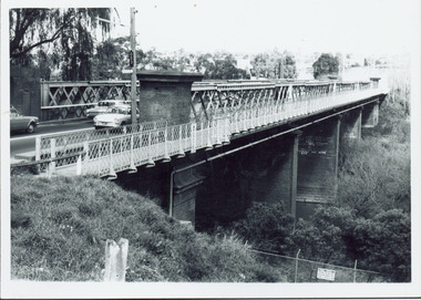
Photograph - Chandler Highway Bridge, 1977
The heritage listed Fairfield Bridge was originally constructed for the Outer Circle Railway to bridge the Yarra River between East Kew and Fairfield stations. In the 1930s it was converted for vehicular traffic. In the 2010s a new concrete bridge was erected beside it to increase vehicular capacity.Print copy of the Chandler Highway Bridge, [formerly the Fairfield Viaduct of the Outer Circle Railway] showing the original position of the walkway beside the bridge. The POV is from the Fairfield side looking towards Kew. CHANDLER HWY BRIDGE OVER YARRA / OCTOBER 1977 / ORIGINALLY BUILT FOR OUTER CIRCLE RWYchandler highway bridge, outer circle railway viaduct, bridges -- kew (vic.) -
 Kew Historical Society Inc
Postcard, R McGeehan, The Effect of Storm. Train Passing Through Flood Waters, South Yarra, 25-1-07, 1907
SHARP DOWNPOUR. ONE INCH IN 45 MINUTES. SOUTHERN SUBURBS DELUGED. TRAIN STOPPED AT SOUTH YARRA. One of the sudden downpours of rain which occasionally fall in Melbourne occurred yesterday afternoon, when nearly an inch of rain fell in the course of three quarters of an hour, and caused a flood for an hour or two in certain localities. During the early part of the day, the sky had been clouded over, but there was nothing to indicate a storm of such intensity as that which followed. At about half-past 1 o'clock residents of South Yarra, South Melbourne, Prahran, and St. Kilda noticed a few drops of rain. Still, it appeared unlikely that there would be anything exceptional, until with startling suddenness at about 10 minutes to 1 o'clock, one of the heaviest downpours within the memory of residents burst upon those suburbs. A strange feature of the storm was that it was practically confined to an area of about three miles square. The city was but little affected, though at a spot as close as the Observatory 86 points of rain were recorded in three-quarters of an hour. Thunder and lightning accompanied the downpour, which was cyclonic in character, the rain driving heavily from all points of the compass as the cyclone passed. It was in South Yarra and Prahran that the rain fell heaviest. Within a few minutes after it commenced, the low-lying portions of Toorak-road and practically the whole length of Chapel-street were under water. The depression at the intersection of Toorak-road and Darling-street speedily filled to the dimensions of a small lake. Several shops were inundated, while the water from the higher levels rushed down like a mountain torrent, and in several in-stances swept through the rear of houses and shops, carrying furniture in a floating mass against the further walls. In one case a footbridge was carried bodily away and dashed to pieces. Darling-street itself Great Davis-street, and other low-lying and flat thoroughfares in the vicinity became flooded from kerb to kerb, while on the other side of the railway-bridge the valley between Kensington-road and River-street became filled for some minutes to a depth of several feet. Meanwhile the waters from South Yarra hill, seeking a lower level, found it in the railway cutting, and the excavations from South Yarra station to Prahran on the one line, and to the Chapel-street bridge on the other, were converted into a couple of canals. At the platforms at South Yarra the water was two feet deep on the permanent way, and towards Hawksburn, at the sudden depression under Chapel-street bridge, it was at one time deep enough to cover a tall man's head. Into this swirling mass of water the 1:50 p.m. train from Oakleigh plunged on its way to Melbourne. The impact caused a mighty fountain of water to rise to a height of about 20 feet above the level of Chapel-street and send clouds of spray in all directions. Under the belief that a terrible explosion had occurred residents braved the rain and rushed to the spot, only to find that the train had been brought to a stand-still in the middle of what seemed to be a river. The water was so high that it had entered the fire-box from below, extinguishing the fires and cutting off the steam supply. In the meantime the officials at the South Yarra station had been preparing for emergencies. Inspectors were on duty at intervals along the line, and the moment the alarm was given an extra engine was backed carefully down and continued on to connect with the stranded train without losing its own power. There was a delay of about ten minutes in the service for an hour or two, but by 5 o'clock all the trains were running on time again, and the water had run off all but the spot beneath the Chapel-street bridge. Here the water remained about four feet deep until nightfall, and throughout the afternoon several hundreds of people including biograph operators and photographers, were gathered around watching each train pass through. Even with the water two feet lower, this was a work attended with considerable difficulty. Each train had to absolutely force its way through the weight of water, almost enveloped by the spray thrown up, and it was only just able to negotiate the "ford" by using every ounce of steam. ... The Argus, 26 January 1907, p19.The item forms part of the Laurie Bennett collection of thirty-six postcards and photographs of Kew and early Melbourne, donated to the Kew Historical Society in 1980. The postcards in the Bennett collection, like other images in the Society's holdings date from the 1890s to the present and comprehensively indicate points-of-view or scenes considered historically, aesthetically or socially significant in the period in which they were produced.Postcard depicting a flood at South Yarra Station in 1907. The title and photographer's name are identified on the front of the postcard. Donated by L. Bennett, 1980flood - south yarra, trains - melbourne, postcards, r mcgeehan - prahran -
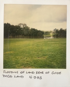
 Kew Historical Society Inc
Photograph - Flooding of shared path at rear of Guide Dogs Victoria, 1993
The land currently occupied by Guide Dogs Victoria was once part of the grounds of the Kew Lunatic Asylum. This includes the land, designated as parkland which adjoins the Yarra River. Original colour small format polaroid photograph of flooding in parkland at the rear of Guide Dogs Victoria in the area now used as the Main Yarra Trail; taken on 16 September 1993."Flooding of shared path on 16.9.93 / Rains 15.9.93 - rear Guide Dogs [Victoria] land"yarra river -- floods -- kew (vic.), guide dogs victoria, main yarra trail, chandler park -
 Kew Historical Society Inc
Photograph - Historic re-enactment during the Festival of Kew, 1978
At the 1978 Festival of Kew, a number of organisations, including the City of Kew, the Kew Historical Society, Trinity Boys Grammar School and local Girl Guides participated in a re-enactment of the expedition of the party of Charles Grimes in surveying the Yarra River as far as Kew in February 1803. The location for the event was Yarra Bend Park near the Studley Park Boat House. The event was organised by the Kew Historical Society. The re-enactment was captured by a number of amateur photographers as well as by a photographer from the local Progress Press.Local communities select events to commemorate according to their shared history and values. Commemorations of colonial exploration were popular with local historical groups such as the Kew Historical Society in the twentieth century. In re-enacting events such as the Grimes survey of the Yarra, students from a local school were encouraged to take on specific roles, including play-acting individuals involved in the survey party as well as members of the local Wurundjeri People. The photographs, taken by amateur and professional photographers, represent a period in time when the dominant values were those shared by the descendants of European settlers in Victoria. Original colour photographic positive of two schoolboys, dressed as Wurundjeri warriors, who were participants in the Charles Grimes re-enactment at Yarra Bend during the 1978 Festival of Kew. Annotated on reverse: "(NATIVES) RE-ENACTMENT OF GRIMES' 1803 EXPEDITION / FESTIVAL 1978 / DONATED BY M. ROLLEY"kew historical society, trinity grammar school, kew girl guides, city of kew, yarra river, charles grimes, collins expedition, wurundjeri people, yarra bend park, colonial surveys, historic re-enactments, festival of kew, kew festival -
 Greensborough Historical Society
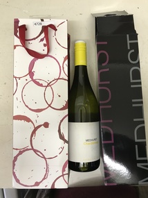
Bottle and Apron, Primary Edge Promotions, Medhurst Bottle and Apron, 2016_
Medhurst Wines operates in Gruyere, Yarra Valley. The winery is on land once owned by David Medhurst, formerly of Greensborough. These items were a gift to David's descendant, Faye Fort (nee Partington).Clear glass wine bottle 750 ml, screw cap, in black cardboard presentation box in red and white gift bagLabelled Medhurst Chardonnay 2016 Yarra Valley; with, black poly cotton apron, with pocket, embroidered Medhurst in white.medhurst family, medhurst wines yarra valley -
 Kew Historical Society Inc
Photograph, Chipperfield's Boat House & Floating Pontoon, 1934
Living with natural processes was frequently a challenge to early European settlers and later residents of what was in the 1850s administered by the Borondara Road Board. This was compounded by the area being bounded on three sides by rivers (Yarra River, Koonung Creek and Gardiner's Creek). In 1849, the historian James Bonwick recorded that "our district [Kew] suffered considerably. Mr Wade speaks of 80 acres, out of 100 acres of his cultivated paddock, covered by water." Newspapers continued to describe major flooding in Kew in 1863, 1869, 1878, 1880, 1889, 1891, 1916 and 1934. While the construction of the Upper Yarra dam in 1957 reduced the levels of flowing downstream, local and riverine floods continue. A number of boat houses operated on both sides of the River Yarra at Kew. Chipperfield's Boat House was located on the Yarra near the corner of Kilby and Willsmere Roads.The Kew Historical Society's pictures and map collections testify to the impact of flooding in the district. They have historical importance in documenting the extent of flooding in the district and its affects on homes, services and recreation. Numerous photographs record flooding throughout the Twentieth Century.Floating pontoon at Chipperfield's Boat House where the canoes were stored, taken in 1934, presumably before the 1934 Flood. This area of the Yarra was shallow with a number of mid river sandbanks and a popular swimming area for locals.yarra river, chipperfield's boathouse, pontoon -
 Kew Historical Society Inc
Photograph - Yarra Valley Floods: Kew East, 1916
Flooding of the Yarra Valley, including that section of the Yarra bordering Kew and Kew East in the north and west of the municipality, was a regular occurrence. Extreme flood events of the Yarra River are recorded to have occurred in 1891, 1901, 1916, 1923 and 1934. The Municipality of Kew's response to these floods was to enact planning decisions restricting residential development in flood prone areas following the floods of 1916, 1921 and 1934. While floods continued after the development of the Upper Yarra Reservoir (construction 1948-57), the regularity and extent of these inundations diminished. During the nineteenth century, the land abutting the south side of the Yarra in Kew was devoted to dairy farming. In the twentieth century, before and after the construction of the Eastern Freeway, much of this low-lying area was used as golf courses and public parks.One of a collection of photographs of flooding in the Kew section of the Yarra Valley which are in important research resource for the location and extent of flooding in the first half of the twentieth century. Flooding of the Yarra Valley at East Kew in 1916. The view is taken from the intersection of Kilby Road with what is believed to be Birdwood Street, looking across the flood waters to Ivanhoe. The extensive flooded area shown in the photograph would have included the Kew Golf Club. Verso: "Floods along Kilby Road / near Birdwood St? & Kilby Road / 1917? / 87yarra river, yarra valley, floods -- kew, kilby road -- kew (vic.), kew golf club -
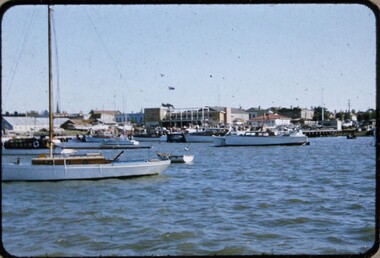
 Melbourne Legacy
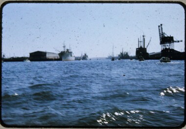
Slide, Operation Float 1957, 1957
A colour slide small boats on the Yarra River or Port Philip alongside larger moored boats in 1957. Operation Float was an event run by Melbourne Legacy to take Junior legatees on an outing. It could have been to naval boats such as HMAS Cerberus or to a Yacht club. It gave the junior legatees the opportunity to see a naval boat in action, spend time on the water or try sailing. In 1957 it appears to be several smaller boats taking small groups of children out on the bay. Was with many other slides taken in the 1950s and 1960s. The slides have been photographed to make digital images and moved to archive quality sleeves. In many cases the original images were not well focussed and the digital image the best available.A record of outings being organised for children.Colour slide of small boats on the Yarra or bay in a red edged Kodachrome cardboard mount.Printed on reverse in red ink 'Kodachrome Transparency / Processed by Kodak'. Handwritten in blue ink 'Heading up river / 22 / 1957'. Imprinted in black ink '19'operation float, junior legatee outings -
 Melbourne Legacy
Slide, Operation Float 1957, 1957
A colour slide small boats on the Yarra River or Port Philip in 1957. Operation Float was an event run by Melbourne Legacy to take Junior legatees on an outing. It could have been to naval boats such as HMAS Cerberus or to a Yacht club. It gave the junior legatees the opportunity to see a naval boat in action, spend time on the water or try sailing. In 1957 it appears to be The Royal Victorian Motor Yacht Squadron using several smaller boats taking small groups of children out on the bay. Was with many other slides taken in the 1950s and 1960s. The slides have been photographed to make digital images and moved to archive quality sleeves. In many cases the original images were not well focussed and the digital image the best available.A record of outings being organised for children.Colour slide of small boats on the Yarra or bay in a red edged Kodachrome cardboard mount.Printed on reverse in red ink 'Kodachrome Transparency / Processed by Kodak'. Handwritten in blue ink 'RVMYC who gave us Operation Float / 26 / 1957'. Imprinted in black ink '20'.operation float, junior legatee outings -
 National Wool Museum
Book, Modern Developments in the Australian Wool Industry
"Modern Developments in the Australian Wool Industry", c.1923. Examines the operations of the Yarra Falls Spinning Co. Pty Ltd and the Australian Knitting Mills Limited (makers of Golden Fleece and Kookaburra knitted underwear). Includes photos of processes and of the buildings.Book, front cover: "Modern Developments in the Australia Woollen Industry" c.1923; Yarra Falls Spinning Co. Pty Ltd and Australian Knitting Mills Limited.weaving textile industry - history textile production machine knitting textile mills, yarra falls spinning co. pty ltd australian knitting mills limited, yarn - woollen, cloth - worsted, yarn - worsted, wool tops, yarn - cashmere, logo merino: sheep in australian art and design - exhibition (29/07/2000 - 04/02/2001), weaving, textile industry - history, textile production, machine knitting, textile mills -
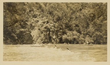 Kew Historical Society Inc
Photograph - Victorian Canoe Club, Shooting the rapids, Warrandyte, 1930–35
Canoeing on the River Yarra at Melbourne was an important and widespread recreational pursuit for Melbournians, especially in the first half of the twentieth century. The Victorian Canoe Club was formed in 1912 at a meeting in Melbourne and its first committee elected in the same year. Records indicate that the Club continued into at least the 1950s .The photos in this album are historically and socially significant as a record of recreational activities in the first half of the twentieth century. A number of photographs in the album provide views of sections of the Yarra, as well as areas in regional Victoria, that may otherwise be unavailable.One of 12 sepia [faded] photographs of members of the Victorian Canoe Club. This photo shows members of the club in canoes, travelling through the rapids on the Yarra at Warrandyte."Shooting the rapids, Warrandyte"victorian canoe club, travel -- 1930s, canoeing, warrandyte, yarra river -
 Kew Historical Society Inc
Photograph - Flooding at parkland at rear of Guide Dogs Victoria, 1993
The land currently occupied by Guide Dogs Victoria was once part of the grounds of the Kew Lunatic Asylum. This includes the land, designated as parkland which adjoins the Yarra River. It is now designated as the Chandler Park.Original colour small format polaroid photograph of flooding in parkland at the rear of Guide Dogs Victoria in the area now used as the Main Yarra Trail; taken on 16 September 1993."Flooding of land rear of Guide Dogs land 16.9.93"yarra river -- floods -- kew (vic.), guide dogs victoria, main yarra trail, chandler park -
 Federation University Historical Collection
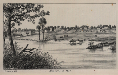
Image, John Helder Wedge, Melbourne in 1838, 1938
The following information is from http://melbourneday.com.au/about.html, accessed 30 August 2016 Melbourne was founded on 30 August 1835 by settlers who sailed from Van Diemen’s Land (Tasmania) aboard the schooner Enterprize. They landed on the north bank of the Yarra River and established the first permanent settlement, close to where the Immigration Museum at the Old Customs House — on the corner of William and Flinders Streets — stands and the place today known as Enterprize Park. Melbourne Day Committee was established to help correct the record about the founding of Melbourne and celebrate its anniversaries. The settlers came from Launceston in search of sheep-grazing land. Land had become expensive and there had long been stories told by whalers and sealers working in Bass Strait of fertile land to the north. This was the southern part of the colony of New South Wales, which the Colonial Government did not want settled at that time. After the Henty family crossed Bass Strait and settled at Portland in 1834 others quickly followed. The north bank was chosen because a small waterfall, or rapids, stopped further progress up the river. The waterfall also separated the tidal movement, providing a vital supply of fresh water. The site had previously been noted by the colony of New South Wales' surveyor, Charles Grimes, in 1803. The north bank also offered more stable, suitable ground. The people of the Kulin nation are the traditional owners of the land that became Melbourne — including the Boonwurrung, Woiwurrung, Taungurung and Djadjawurrung people, who gathered in this place for ceremonies and cultural activities. The topsail schooner Enterprize you see today is a full-size replica of the one that brought the settlers and has become a symbol of Melbourne Day. Her keel was laid at Polly Woodside Maritime Museum in 1991, and the $2.5 million, 27m vessel was launched by Felicity Kennett on 30 August, 1997, at Hobsons Bay. The original ship was bought by John Pascoe Fawkner in April 1835 specifically to search for a suitable place for a settlement in the Port Phillip District. After helping establish Melbourne, the original Enterprize continued operating as a coastal trading vessel for a number of years. She eventually disappeared off the shipping register in 1847, having been wrecked on a sand bar in the Richmond River in northern NSW, with the loss of two lives. The replica is managed by the Enterprize Ship Trust, a not-for-profit organisation. The first settlers were those on board the Enterprize — her crew and passengers. They were John Lancey , master mariner and Fawkner’s representative; Enterprize's captain, Peter Hunter; George Evans, plasterer/builder; carpenters William Jackson and Robert Hay Marr; Evan Evans, George Evans’ servant; and Fawkner’s servants ploughman Charles Wise, general servant Thomas Morgan, blacksmith James Gilbert and his pregnant wife, Mary. And Mary's cat! Enterprize set sail on her historic voyage from Launceston on July 21, 1835, stopping at George Town in northern Tasmania where creditors detained Fawkner. He was therefore not part of the first trip to Melbourne. Enterprize then left on August 1 under the command of captain Hunter. The expedition was led by Lancey, Fawkner's delegate. The party first considered Western Port and the eastern side of Port Phillip for a place to settle, before deciding on the Yarra’s north bank — known today as Enterprize Park. On Sunday, August 30, they disembarked and began to erect shelter, build a store and clear land to grow food, thus starting the permanent European settlement of Melbourne.Image of the fledgling town of Melbourne on the banks of the Yarra River. melbourne, yarra river, john helder wedge -
 Marysville & District Historical Society
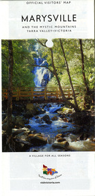
Map (Item) - Map and touring guide, Murrindindi Regional Tourism Association Inc, MARYSVILLE AND THE MYSTIC MOUNTAINS YARRA VALLEY-VICTORIA, Unknown
... MARYSVILLE AND THE MYSTIC MOUNTAINS YARRA VALLEY-VICTORIA ...A fold out map and touring guide of Marysville and the surrounding district published by Murrindindi Regional Tourism Association Inc.A fold out map and touring guide of Marysville and the surrounding district published by Murrindindi Regional Tourism Association Inc.marysville, victoria, australia, map and touring guide, the cumberland, murrindindi regional tourism association inc, abbey green b&b, amberview lodge, anastasia fairytale cottage, ashlar cottage b&b, blackwood cottages, camellia log cabin, crossways country inn, dalrymples guest cottages, eagle mountain retreat, esa camping and conference centre, fruit salad farm, gilberts restaurant, keppels hotel motel, kerami house, kooringa resort and conference centre, lomatia lodge, lyelll guest cottages, marylands country house, marylyn holiday resort, marysville caravan park, marysville visitor information centre, alpacas at carmyle farm, australian adventure experience, bruno's art and sculpture garden, buxton trout farm, country touch tours, lake mountain, lake mountain ski hire, manical mechanicals, marysville district country club, marysville ski centre, rubicon valley horse riding, things of sand & stone, clearstream olives, the old woolshed cafe, fraga's cafe restaurant, lake mountain resort bistro, mantirri blueberry farm, gallipoli park, keppels lookout, cambarville, lady talbot drive, cathedral range state park, steavenson falls, steavenson river, taggerty river, acheron river, marysville auto and hardware, marysville newsagency & general store, narbethong visitor information centre, visit victoria -
 Marysville & District Historical Society
Map (Item) - Map and touring guide, Murrindindi Regional Tourism Association Inc, MARYSVILLE AND THE MYSTIC MOUNTAINS YARRA VALLEY-VICTORIA, Unknown
... MARYSVILLE AND THE MYSTIC MOUNTAINS YARRA VALLEY-VICTORIA ...A fold out map and touring guide of Marysville and the surrounding district published by Murrindindi Regional Tourism Association Inc.A fold out map and touring guide of Marysville and the surrounding district published by Murrindindi Regional Tourism Association Inc.marysville, victoria, australia, map and touring guide, the cumberland, murrindindi regional tourism association inc, abbey green b&b, amberview lodge, anastasia fairytale cottage, ashlar cottage b&b, blackwood cottages, camellia log cabin, crossways country inn, dalrymples guest cottages, eagle mountain retreat, esa camping and conference centre, fruit salad farm, gilberts restaurant, keppels hotel motel, kerami house, kooringa resort and conference centre, lomatia lodge, lyelll guest cottages, marylands country house, marylyn holiday resort, marysville caravan park, marysville visitor information centre, alpacas at carmyle farm, australian adventure experience, bruno's art and sculpture garden, buxton trout farm, country touch tours, lake mountain, lake mountain ski hire, manical mechanicals, marysville district country club, marysville ski centre, rubicon valley horse riding, things of sand & stone, clearstream olives, the old woolshed cafe, fraga's cafe restaurant, lake mountain resort bistro, mantirri blueberry farm, gallipoli park, keppels lookout, cambarville, lady talbot drive, cathedral range state park, steavenson falls, steavenson river, taggerty river, acheron river, marysville auto and hardware, marysville newsagency & general store, narbethong visitor information centre, visit victoria -
 Wonga Park Community Cottage History Group
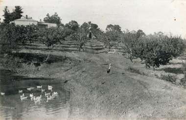
Photograph (sub-item) - Black and White, The Read family orchard around 1930, which was situated on the corner of Yarra and Toppings Road. The old home still stands in Yarra Road in 1985
... the corner of Yarra and Toppings Road. The old home still ... -
 Wonga Park Community Cottage History Group
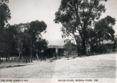
Photograph (sub-item) - Black and White, The Kiosk/Store in Wonga Park about 1948, owned by Mr. Arthur Davis. This view is from the intersection of Yarra and Jumping Creek Roads
... . Arthur Davis. This view is from the intersection of Yarra and ... -
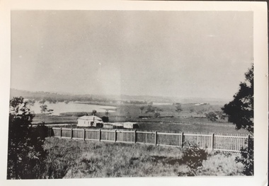 Kew Historical Society Inc
Photograph - Yarra in Flood - Belford & Kilby Farms, 1903
The Yarra Valley in what was previously called North Kew, but is now East Kew, was frequently subjected to flooding. Apart from some development on higher ground, the City of Kew regularly introduced restrictions on development and the building of housing in the area because of flood levels. Panoramic photographic positive of North Kew where the Belford and Kilby Farms were located on the south side of the Yarra River. This photo is a copy of the original photo in the collection.floods -- yarra -- 1903, kew golf course, greenacres golf course -
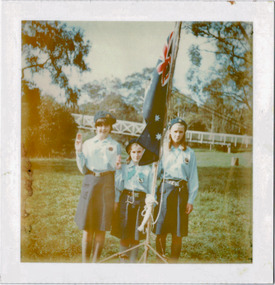 Kew Historical Society Inc
Photograph - Historic re-enactment during the Festival of Kew, 1978
At the 1978 Festival of Kew, a number of organisations, including the City of Kew, the Kew Historical Society, Trinity Boys Grammar School and local Girl Guides participated in a re-enactment of the expedition of the party of Charles Grimes in surveying the Yarra River as far as Kew in February 1803. The location for the event was Yarra Bend Park near the Studley Park Boat House. The event was organised by the Kew Historical Society. The re-enactment was captured by a number of amateur photographers as well as by a photographer from the local Progress Press.Local communities select events to commemorate according to their shared history and values. Commemorations of colonial exploration were popular with local historical groups such as the Kew Historical Society in the twentieth century. In re-enacting events such as the Grimes survey of the Yarra, students from a local school were encouraged to take on specific roles, including play-acting individuals involved in the survey party as well as members of the local Wurundjeri People. The photographs, taken by amateur and professional photographers, represent a period in time when the dominant values were those shared by the descendants of European settlers in Victoria. Original colour photographic positive of three girl guides who were attending the Charles Grimes re-enactment in 1978. The guide on the left is Kate Smith and the guide on the right holding the Australian flag is Ann Wilson. The name of the guide in the middle has been obscured by glue and paper. Kanes Bridge is in the background. Annotated on reverse: "KATE SMITH *** ANN WILSON / FESTIVAL 1978 / GRIMES RE-ENACTMENT AT YARRA BEND / DONATED BY M. ROLLEY"kew historical society, trinity grammar school, kew girl guides, city of kew, yarra river, charles grimes, collins expedition, wurundjeri people, yarra bend park, colonial surveys, historic re-enactments, festival of kew, kew festival -
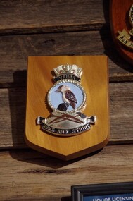 Running Rabbits Military Museum operated by the Upwey Belgrave RSL Sub Branch
Plaque HMAS Yarra
HMAS Yarraplaque, ran -
 University of Melbourne, Burnley Campus Archives
Photograph, James Leslie Provan, Burnley 1942 Album Page 1, 1942
Yarra Boulevard.yarra boulevard, burnley, 1942, j.l. provan -
University of Melbourne, Burnley Campus Archives
Photograph - Sepia Print, 4. View of River Through Fence
Yarra River.Labelled, " View of River through fence."yarra river, mrs. jessep, alexander william jessep, principal, a.w. jessep -
 Kew Historical Society Inc
Map, MMBW, River Yarra Beautification Schemes, c.1913
The Melbourne and Metropolitan Board of Works (MMBW) was established by an act of the Victorian Parliament in 1890 to prepare for and to implement a sewerage and water reticulation system across what was then inner Melbourne, its surrounding and middle distance suburbs, including Kew. The MMBW was disbanded in 1991.The map collection of the Kew Historical Society has at its core the historic maps assembled and originally stored in the City Engineer's Department of the City of Kew. These include maps in a number of scales. The vast majority of maps were produced by the MMBW in the first two decades of the twentieth century, and are solid working maps, backed by linen for durability. These maps are historically significant to Kew, the City of Boroondara and to the history of the development of state utilities in Victoria. A number of the Kew maps have additional details added by former municipal officers, including the levels reached by various floods. As these were working documents, information was added to them long after the period of their initial production and distribution.Map of the City of Kew showing part of the River Yarra Beautification Schemes. The map shows development to date and the flood levels reached in 1923 and 1924. This map may have been adapted from an earlier map, as most development in central Kew and Studley Park had occurred by this date yet numerous streets are not represented. Public buildings and institutions are clearly represented and named on the map as are significant public transport infrastructure (eg the Outer Circle railway).MELBOURNE AND METROPOLITAN BOARD OF WORKS / RIVER YARRA BEAUTIFICATION SCHEMES / SCHEME / SCALE 10 CHAINS TO AN INCHmelbourne & metropolitan board of works, mmbw maps, mmbw plans, city of kew, flood levels -- kew (vic.), cartography -
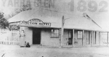 Yarra Glen & District Historical Society
Black and white photographs, Junction Hotel, Yarra Glen
The Junction Hotel was built before 1875. It was located on the corner of the Yarra Glen-Eltham and Steels Creek Roads opposite the cemetery. The building was burnt down in August 1935. Samuel Smith was the licensee from 1895 until 1905Black and white photograph of the Junction Hotel, Yarra Glen copied from newspaper. The words "YARRA GLEN 1892" appear above the building. Sign on building "S.SMITH JUNCTION HOTEL LICENSED VICTUALLER". A woman wearing an ankle-length dress and boots is standing near main entrance. Weatherboard and iron roof, picket fence. Two bentwood chairs on brick-floored verandah. A light pole is attached to the verandah post. picket fence, nineteenth century, 19th century, hotel, bentwood chair, public house, sam smith, samuel smith, weatherboard, iron roof, tin roof, woman, junction hotel -
 Uniting Church Archives - Synod of Victoria
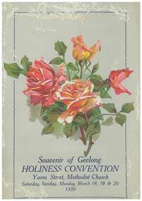
Program, Souvenir of the Holiness Convention, 1939
The convention was held in the Yarra Street Methodist Church, Geelong on the 18th, 19th, 29th June 1938. It was arranged and convened by the Methodist Local Preachers' Association.Souvenir program for the 23rd Holiness Convention. The program is pale green with a painting of four red and orange roses on its cover. Front cover: "Souvenir of Geelong HOLINESS CONVENTION Yarra Street Methodist Church, Saturday, Sunday, Monday March 18,19 & 20 1939"" methodist local preachers' association melbourne branch, yarra street methodist church, geelong -
Mount Evelyn History Group
Book Aboriginal Database, Tarcoola Press, Birrarung Database, Published 2012
Book with information on the history of the Wurundjeri people of the Yarra Valley, from the time of first European contact, arranged according to topic, e.g. law, ceremony, language, lifestyle, personalities, reconcilation.Sepia toned soft cover book with illustrations: engraving 'The Battle of Yering' by Margo Heeley; photograph 'The Yarra River' by Mick Woiwod'; sketch 'When Blacks First Saw Ships' by Tommy McCrae. Top: 'Birrarung Database' Bottom: 'compiled by Mick Woiwod Published by Tarcoola Press'aborigine, wurundjeri, woiwurrung, yarra, birrarung, woiwod -
 Kew Historical Society Inc
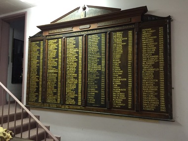
Memorabilia, MUIOOF: Port Phillip District/Yarra Yarra District Honour Board, 1930
The MUIOOF Lodge was located in Union Street, Kew. The Lodge was established in 1863. It was demolished in the early 1990s.The Lodge Board lists the names of representatives of many of Kew's pioneering families. The Board was donated to the Society when the Hall was demolished. MUIOOF Lodge Board - Yarra Yarra District, Loyal Kew Lodge No. 5093 Port Phillip District till 1888 / Yarra Yarra District from 1888 Past Grands [listed] W.Woolard 1864 to A.E. Martin 1990 Maker marks - [Painted on back panel] "Lodge Board - Written by Bro. J. Kleiner, Signwriter 432 Burwood Rd. Glenferrie March 1930".[Engraved on pediment] "G.E. Gosbell, Woodcarver 1955". muioof (kew), yarra yarra district, port phillip district, j. kleiner, manchester unity independent order of oddfellows, w. woollard, d. gray, g. taylor, d. dannock, e.g. backwell, s. conder, j.h. joyce, r. summers, r. clulow, w. morris, f. fanhauser, j. waters, w. butson, a. dalton, t.g. jellis, j. watson, w. howieson, a.h. alexander, w.h. perry, a.r. studd, t. greenhill, w.a. hunt, w. maslen, t. eakins, h. ellis, a. geoffrey, j. priestman, t.e. morrisjamieson, c.h. bryan, g. hinchcliffe, t. foley, a.j. conder, s. clapham, a. cornish, f.j. fauvel, e.m. bond, h. co, j.g m. moller, e. hillier, w. finucane, w.e. bristow, v. geoffrey, a. hill, j.t. studd, h. de c. kellett, a.j whittaker, e. foley, e.f. fordred, p.j. ridgeway, j. barnard, h.a. ingham, h. woollard, j.w. fuller, e. mclean, p.g. pearce, f. walsh, h. fryar, h. salisbury, h. woolard, h.c. cox, a.j. watson, w. holt, f.t. james, e.c. parry, g. lees, h.o. ada,s, g.c. barclay, g.h. mockridge, g. philpott, j. corser, a. lilburn, w.p. wheeler, t.e. morri, r.r. clarke, h.d. sisson, w.r. harle, w.g. gray, j.d. newman, c.w. laidler, e.a. rae, a.a. homes, a. mcconachie, h.f. woollard, p.g. gallop, h.c. nelson, l.n. graebe, e.w. firth, n. rae, r.j. kelly, j. donaldson, f.t. jmes, c. till, t.j. doyle, s.m.f wills, w.l. smith, h. mcallan, h.a. morgan, a. kinns, w.r. adams, c.h. jones, g.h. carter, m. prout, a.w. bishop, k.c. hemmings, e.k. sparls, l.m. harle, j.m. prout, l.e. watts, d.b. adams, f.u. woolard, a. macrae, n.l. gration, d.h. vickers, m.h.m. alister, t.a. till, r.w. bent, j.w. woolard, a.e. woolard, r.h. harle, jean harle, l.o. adams, d.h. lloyd, k.w. harle, d.g. mclean, p.s. pearse, v.l. profitt, f.c. marks, m.h. mcalister, j. newman, e.m. savory, a.f gration, c.g. teasdale, e.k. sparkes, a.j. scott, w.h. savory, t.r. holland, g.t. smith, d. adams, s. rowe, t. bentley, l.e. fegan, m.j. fiander, g.n. bentley, j.l. oakley, h. brierley, b. oakley, m. j. fiander, w. humphries, a. weingardt, c. nunn, d.a. adams, s.p. clark, s. evans, g.n.bentley, s. clugston, d.c. mitchell, a.e. martin, g.n bentley, l.b. murrell, t.b. will, d. murrell -
 Robin Boyd Foundation
Slide, Robin Boyd, 1967
Colour slide in a mount. Alexandra Parade, by the Yarra River, South Yarra, Victoria, AustraliaMade in Australia / 28 / JUN 67M6 / Encircled 34 (Handwritten)slide, robin boyd -
 Eltham District Historical Society Inc
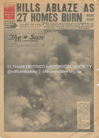
Newspaper - Newspaper articles, Sun News-Pictorial, Hills Ablaze As 27 Homes Burn, The Sun News-Pictorial, Monday, January 15, p1, 1962
Various news articles pertaining to the January 1962 Victorian bushfires in the Dandenong and Healesville districts. • Hills Ablaze As 27 Homes Burn; Night Fight, p1 (Illust.) • Yarra Glen, Healesville Saved; Fire into main street, p2 (Illust.) • Flare-up at Montrose, p2 • 20 scouts flee as fire sweeps camp, p2 • Gaol for fires today …, p2 • Timber lost, p2 • Heathmont home lost, but others saved, p2 • The desperate fight, p3 (Illust.) • Rubbish fire got away; Basin blaze, p3 • Panorama of destruction, p3 • Fire Captain Killed; 7 road deaths at week-end, p5 (Illust.) • Heartbreak, ruin as … Fire Sweeps the Hills, pp18-19 .(Illust.) • Tea; they made it for the fire fighters, pp18-19 (Illust.) tom fielding collection, victorian bushfires - 1962, victorian bushfires – 1962, dandenongs, the basin, yarra glen, healesville, montrose, chum creek, scouts, australian logging co., a.w. larkins, heathmont, vermont, r. pearson, mike ryan, vic parker, c.g. wilson, hillside farm, clive brewer, ron anderson, mrs anderson, mt dandenong, healesville rural fire brigade, malcolm barber, yarra flats, r. bicknell, ferny creek, blue hills gues house, heatherset road, sassafras, olinda, presbyterian manse, john gorie, janice gorie, lynette gorie, jacky wilson, patricia cortie -
 Whitehorse Historical Society Inc.
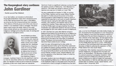
Article - John Gardiner, 23/06/2021
John Gardiner was born in Dublin 1798. He was a pastoralist and banker and arrived at Port Phillip in 1836 and with his cousin William Fletcher laid claim to 15,000 acres at the junction of the Yarra River and Kooyongkoot CreekJohn Gardiner was born in Dublin 1798. He was a pastoralist and banker and arrived at Port Phillip in 1836 and with his cousin William Fletcher laid claim to 15,000 acres at the junction of the Yarra and Kooyongkoot Creek.non-fictionJohn Gardiner was born in Dublin 1798. He was a pastoralist and banker and arrived at Port Phillip in 1836 and with his cousin William Fletcher laid claim to 15,000 acres at the junction of the Yarra River and Kooyongkoot Creekgardiner john, gardiners creek