Showing 4028 items
matching hill's house
-
 Buninyong & District Historical Society
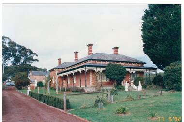
Photograph - Original Colour Photograph, Anne Beggs-Sunter, "Mount Helen" built c. 1888, 17 May 1992
Example of late 19th Century home built by Irving and Glover for Abraham Baxter, a well known engineer, railway contractor and horse racing enthusiast. The estate consisted of about 300 acres, taking in the northern and eastern faces of Green Hill. The family lived at "Mt. Helen" until 1908. The house has been restored in recent in recent years.The fine brick house is an example of late 19th century home built and occupied by the Baxter family until 1908.Colour photograph of "Mount Helen" built c.1888 by Irving and Glover"Mt. Helen". built c. 1888building, green hill, irving and glover, abraham baxter -
 Buninyong & District Historical Society
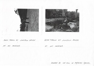
Photograph - Photocopy of two original B/W photographs, Mt Mercer Junction Bridge, photocopy made in 1995
Photos taken of the Junction Bridge at Mt Mercer, documenting the location, date unknown.The photos document the physical status of the location of the Junction Bridge at Mt Mercer at the time of photography, date unknown.Mt Mercer Junction Bridge. Photo 1 shows two men on the river bed probably looking at the bridge. Photo 2 shows Elsie Gibson sitting on the river bank with the bridge in the background.Photo 1. Photo taken at Junction Bridge at Mt Mercer. Photo 2. Elsie Gibson at Junction Bridge at Mt Mercer. Donated by Ian Hill of Hepburn Springsjunction bridge, mt mercer, bridge, elsie gibson, gibson, landscape -
 Buninyong & District Historical Society
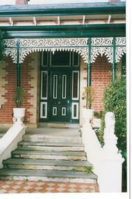
Photograph - Original Colour Photograph, Anne Beggs-Sunter, Front door of "Mount Helen" built c. 1888, 17 May 1992
Example of late 19th Century home built by Irving and Glover for Abraham Baxter, a well known engineer, railway contractor and horse racing enthusiast. The estate consisted of about 300 acres, taking in the northern and eastern faces of Green Hill. The family lived at "Mt. Helen" until 1908. The house has been restored in recent in recent years.The fine brick house is an example of late 19th century home built and occupied by the Baxter family until 1908.Colour photograph of the front entrance to "Mount Helen" built c.1888 by Irving and Glover"Mt. Helen". built c. 1888building, green hill, irving and glover, abraham baxter -
 Buninyong & District Historical Society
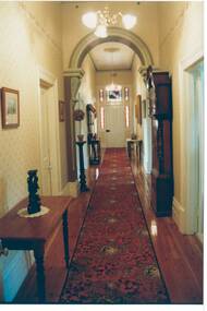
Photograph - Original Colour Photograph, Anne Beggs-Sunter, Interior hallway of "Mount Helen" built c. 1888, 17 May 1992
Example of late 19th Century home built by Irving and Glover for Abraham Baxter, a well known engineer, railway contractor and horse racing enthusiast. The estate consisted of about 300 acres, taking in the northern and eastern faces of Green Hill. The family lived at "Mt. Helen" until 1908. The house has been restored in recent in recent years.The fine brick house is an example of late 19th century home built and occupied by the Baxter family until 1908.Colour photograph of the interior hallway of "Mount Helen" built c.1888 by Irving and Glover"Mt. Helen". built c. 1888building, green hill, irving and glover, abraham baxter, interior -
 Surrey Hills Historical Society Collection
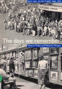
Book, Eleanor Finlay et al, The days we remember
Picture history of Box Hill showing the development of the area from 1960 - 1994 with rapid population growth and major administrative changes. Photos include government, community services, industry, transport, shops, churches, sport, entertainment and arts, people, schools, houses and "Salute to Box Hill" (the end of Box Hill as a City).A4 size paperback bound booknon-fictionPicture history of Box Hill showing the development of the area from 1960 - 1994 with rapid population growth and major administrative changes. Photos include government, community services, industry, transport, shops, churches, sport, entertainment and arts, people, schools, houses and "Salute to Box Hill" (the end of Box Hill as a City).local history, local government, community services, industry, transport, shops, churches, sport, entertainment, art, schools, houses, 1960-1969, 1970-1979, 1980-1989, 1990-1999, box hill -
 Kew Historical Society Inc
Plan, Melbourne & Metropolitan Board of Works : Borough of Kew : Detail Plan No.1585, 1904
The Melbourne and Metropolitan Board of Works (MMBW) plans were produced from the 1890s to the 1950s. They were crucial to the design and development of Melbourne's sewerage and drainage system. The plans, at a scale of 40 feet to 1 inch (1:480), provide a detailed historical record of Melbourne streetscapes and environmental features. Each plan covers one or two street blocks (roughly six streets), showing details of buildings, including garden layouts and ownership boundaries, and features such as laneways, drains, bridges, parks, municipal boundaries and other prominent landmarks as they existed at the time each plan was produced. (Source: State Library of Victoria)This plan forms part of a large group of MMBW plans and maps that was donated to the Society by the Mr Poulter, City Engineer of the City of Kew in 1989. Within this collection, thirty-five hand-coloured plans, backed with linen, are of statewide significance as they include annotations that provide details of construction materials used in buildings in the first decade of the 20th century as well as additional information about land ownership and usage. The copies in the Public Record Office Victoria and the State Library of Victoria are monochrome versions which do not denote building materials so that the maps in this collection are invaluable and unique tools for researchers and heritage consultants. A number of the plans are not held in the collection of the State Library of Victoria so they have the additional attribute of rarity.Original survey plan, issued by the MMBW to a contractor with responsibility for constructing sewers in the area identified on the plan within the Borough of Kew. The plan was at some stage hand-coloured, possibly by the contractor, but more likely by officers working in the Engineering Department of the Borough and later Town, then City of Kew. The hand-coloured sections of buildings on the plan were used to denote masonry or brick constructions (pink), weatherboard constructions (yellow), and public buildings (grey). This plan, which covers parts of High Street, Pakington Street and Derby Street is dominated by two historic Kew mansions: ‘Konetta’ and ‘Ramornie’. Ramornie was constructed in 1890 for James Maitland Campbell, three times Mayor of Kew. Sold in 1940, it became a boarding house known as ‘The Towers’. Now a private residence again, it has only one of its three balconies remaining. The location of the missing two balconies can be seen on the plan. In 1903, the grounds of Ramornie included a large tennis court fronting Pakington Street. The rear of the property is shown as extending to Cobden Street. One of Kew’s oldest hotels, the Prospect Hill Hotel on the corner of High and Cobden Street was established in 1858. The outline of the hotel shown on the plan represents the second building on the site. During the 19th century it was often used for electoral meetings. The Prospect Hill Hotel was to be redeveloped again in 1928, by the local architect Robert McIntyre. Since the 1980s, the hotel has been a live music venue, the home of the Melbourne Jazz Club, a restaurant and a liquor outlet.melbourne and metropolitan board of works, detail plans, maps - borough of kew, mmbw 1585, cartography -
 Kew Historical Society Inc
Plan, Melbourne & Metropolitan Board of Works : Borough of Kew : Detail Plan No.1590, 1905
The Melbourne and Metropolitan Board of Works (MMBW) plans were produced from the 1890s to the 1950s. They were crucial to the design and development of Melbourne's sewerage and drainage system. The plans, at a scale of 40 feet to 1 inch (1:480), provide a detailed historical record of Melbourne streetscapes and environmental features. Each plan covers one or two street blocks (roughly six streets), showing details of buildings, including garden layouts and ownership boundaries, and features such as laneways, drains, bridges, parks, municipal boundaries and other prominent landmarks as they existed at the time each plan was produced. (Source: State Library of Victoria)This plan forms part of a large group of MMBW plans and maps that was donated to the Society by the Mr Poulter, City Engineer of the City of Kew in 1989. Within this collection, thirty-five hand-coloured plans, backed with linen, are of statewide significance as they include annotations that provide details of construction materials used in buildings in the first decade of the 20th century as well as additional information about land ownership and usage. The copies in the Public Record Office Victoria and the State Library of Victoria are monochrome versions which do not denote building materials so that the maps in this collection are invaluable and unique tools for researchers and heritage consultants. A number of the plans are not held in the collection of the State Library of Victoria so they have the additional attribute of rarity.Original survey plan, issued by the MMBW to a contractor with responsibility for constructing sewers in the area identified on the plan within the Borough of Kew. The plan was at some stage hand-coloured, possibly by the contractor, but more likely by officers working in the Engineering Department of the Borough and later Town, then City of Kew. The hand-coloured sections of buildings on the plan were used to denote masonry or brick constructions (pink), weatherboard constructions (yellow), and public buildings (grey). Surveyed by the Board of Works in 1903 and published in 1904, Plan No.1590 shows development north of Cotham Road. While this plan includes built structures in Mary Street, Cotham Road, High Street, Park Hill Road, Kent Street, Ridgeway Avenue, and Ermington Lane (now Ermington Place), only part of this section was notated and coloured in this contractor’s copy. Numerous houses, large and small are named on the plan: ‘Cholula’, ‘Belper’, ‘The Uplands’, ‘Spring Grove’ facing Cotham Road; ‘Marion’ facing Kent Street; and ‘Kia Ora’ facing Ridgeway Avenue.melbourne and metropolitan board of works, detail plans, mmbw 1590, survey plans - borough of kew, cartography -
 Kew Historical Society Inc
Plan, Melbourne & Metropolitan Board of Works : Borough of Kew : Detail Plan No.1591, 1905
The Melbourne and Metropolitan Board of Works (MMBW) plans were produced from the 1890s to the 1950s. They were crucial to the design and development of Melbourne's sewerage and drainage system. The plans, at a scale of 40 feet to 1 inch (1:480), provide a detailed historical record of Melbourne streetscapes and environmental features. Each plan covers one or two street blocks (roughly six streets), showing details of buildings, including garden layouts and ownership boundaries, and features such as laneways, drains, bridges, parks, municipal boundaries and other prominent landmarks as they existed at the time each plan was produced. (Source: State Library of Victoria)This plan forms part of a large group of MMBW plans and maps that was donated to the Society by the Mr Poulter, City Engineer of the City of Kew in 1989. Within this collection, thirty-five hand-coloured plans, backed with linen, are of statewide significance as they include annotations that provide details of construction materials used in buildings in the first decade of the 20th century as well as additional information about land ownership and usage. The copies in the Public Record Office Victoria and the State Library of Victoria are monochrome versions which do not denote building materials so that the maps in this collection are invaluable and unique tools for researchers and heritage consultants. A number of the plans are not held in the collection of the State Library of Victoria so they have the additional attribute of rarity.Original survey plan, issued by the MMBW to a contractor with responsibility for constructing sewers in the area identified on the plan within the Borough of Kew. The plan was at some stage hand-coloured, possibly by the contractor, but more likely by officers working in the Engineering Department of the Borough and later Town, then City of Kew. The hand-coloured sections of buildings on the plan were used to denote masonry or brick constructions (pink), weatherboard constructions (yellow), and public buildings (grey). That area of Kew bordered by Cotham Road, Park Hill Road, Ermington Lane (now Ermington Place), and Belmont Avenue contained some of the significant homes owned by Kew pioneers. Chief among these was ‘Park Hill’ on an enormous lot facing Park Hill Road. The Jubilee History of 1910 noted, six years after this plan was drawn, that: ‘Park Hill Road, forming the southern boundary of the cemetery, takes its name from Park Hill, the residence of Mr. Thomas Judd, who has resided there since December, 1852.’ Other named houses on the plan include ‘Ferndale’ facing Cotham Road; ‘Ermington’ adjacent to Judd’s Park Hill, facing Park Hill Road; and ‘Gilden’ and ‘Mont Belmont’ facing Belmont Avenue. Mont Belmont was designed by the architectural firm of Reed, Henderson and Smart for William George Lilley in 1887 and was completed in 1888. Lilley was Mayor of Kew in 1887-88, a Justice of the Peace and a member of the first Board of Guardians of Kew’s St. Hilary’s Church of England.melbourne and metropolitan board of works, detail plans, survey plans - borough of kew, mmbw 1591, cartography -
 Kew Historical Society Inc
Photograph - Bungalow, probably East Kew, 1920s
The Kew Historical Society's map collection includes a substantial number of real estate subdivision plans, mainly of Kew but also of surrounding suburbs in Melbourne. Most of the subdivision plans date from the 1920s and 1930s when the districts old homes and local farmland were being split up to accommodate residential growth in the postwar period. These early plans were assembled by a local firm, Jas R Mather & McMillan, which had an office in Cotham Road. Many of the plans, and sometimes photos, were annotated by the agents.Subdivision plans are historically important documents used as evidence for the growth of suburbs in Australia. They frequently provide information about when the land was sold as well as evidence relating to surveyors and real estate and financial agents. The numerous subdivision plans in the Kew Historical Society's collection represent working documents, ranging from the initial sketches made in planning a subdivision to printed plans on which auctioneers or agents listed the prices for which individual lots were sold. In a number of cases, the reverse of a subdivision plan in the collection includes a photograph of a house that was also for sale by the agent. These photographs provide significant heritage information relating house design and decoration, fencing and household gardens.The photograph may also be aesthetically significant depending on the importance of the photographic atelier.An unusual bungalow that does not conform to a particular architectural style but which contains eclectic elements of the style of varying periods. The most striking element of the design is the cantilevered veranda that is supported by heavy chains that are attached to the central gable. This deep gable extends across most of the façade, forming an extensive veranda. Parts of this are infilled with screens. Seven wooden posts, whose lower halves are encased in rendered brick pillars, support this gabled veranda. The roof would appear to be covered with corrugated iron. The location of the house, which was advertised for sale, has to date not been identified. The real estate photo is on the reverse of a plan for the Myrtle Hill Subdivision, Kew.bungalows - kew, architecture - 1920s, real estate photographs -
 Kew Historical Society Inc
Plan - Subdivision Plan, J R Mathers & McMillan, Myrtle Hill Estate, East Kew, circa 1949, c.1949
The Kew Historical Society's map collection includes a substantial number of real estate subdivision plans, mainly of Kew but also of surrounding suburbs in Melbourne. Most of the subdivision plans date from the 1920s and 1930s when the districts old homes and local farmland were being split up to accommodate residential growth in the postwar period. These early plans were assembled by a local firm, Jas R Mather & McMillan, which had an office in Cotham Road. Many of the plans, and sometimes photos, were annotated by the agents.Subdivision plans are historically important documents used as evidence for the growth of suburbs in Australia. They frequently provide information about when the land was sold as well as evidence relating to surveyors and real estate and financial agents. The numerous subdivision plans in the Kew Historical Society's collection represent working documents, ranging from the initial sketches made in planning a subdivision to printed plans on which auctioneers or agents listed the prices for which individual lots were sold. In a number of cases, the reverse of a subdivision plan in the collection includes a photograph of a house that was also for sale by the agent. These photographs provide significant heritage information relating house design and decoration, fencing and household gardens.The photograph may also be aesthetically significant depending on the importance of the photographic atelier.Myrtle Hill, at 14 Vista Avenue, Kew, is of local historical and architectural significance as a good example of a large and imposing single-storey Italianate house of the early 1870s surviving in Kew. Originally sited on a large allotment overlooking Normanby Road, the setting of the house has been dramatically altered through extensive subdivision and development. The subdivision plan of the ‘Myrtle Hill Estate’ indicates that in one such subdivision, 11 allotments were created fronting Bowyer Avenue, Myrtle Avenue, and Normanby Road. The outline and building profile of Myrtle Hill is shown on the west side of Bowyer Avenue.The full (typed) title of this subdivision plan is :"Plan of SUBDIVISION of part of CROWN PORTION 83. / at KEW / PARISH OF BOROONDARA. / COUNTY OF BOURKE". / "MYRTLE HILL ESTATE / EAST KEW" In addition to the Title and subtitle, the plan also lists the advantages of the subdivision. -
 Kew Historical Society Inc
Plan - Subdivision Plan, J R Mathers & McMillan, Normanby Estate, c.1913
The Kew Historical Society's map collection includes a substantial number of real estate subdivision plans, mainly of Kew but also of surrounding suburbs in Melbourne. Most of the subdivision plans date from the 1920s and 1930s when the districts old homes and local farmland were being split up to accommodate residential growth in the postwar period. These early plans were assembled by a local firm, Jas R Mather & McMillan, which had an office in Cotham Road. Many of the plans, and sometimes photos, were annotated by the agents.Subdivision plans are historically important documents used as evidence for the growth of suburbs in Australia. They frequently provide information about when the land was sold as well as evidence relating to surveyors and real estate and financial agents. The numerous subdivision plans in the Kew Historical Society's collection represent working documents, ranging from the initial sketches made in planning a subdivision to printed plans on which auctioneers or agents listed the prices for which individual lots were sold. In a number of cases, the reverse of a subdivision plan in the collection includes a photograph of a house that was also for sale by the agent. These photographs provide significant heritage information relating house design and decoration, fencing and household gardens.The photograph may also be aesthetically significant depending on the importance of the photographic atelier.The Normanby Estate, which was adjacent to Normanby Road, Kew East, included thirty-one lots for sale. Streets on the subdivision plan include Adeney Avenue, Park Hill Road, Normanby Road, Weir Street and Wharton Street. Cotham Road and its tramway are shown nearby. The plan is interesting as it shows Wharton Street, named after the architect and town planner George Wharton, who was the first chairman of the Municipality of Kew. The street was to later be renamed Cecil Street. Also shown are proposed ‘Municipal Gardens’ where Parkhill Drive is now located."D" in top left corner. Stamped auctioneers contact details: "Jas. R. Mathers & Son & McMillan / Auctioneer & Land Salesmen, / 271 Collins Street / Melbourne" and Jas. R. Mathers / Estate & Financial Agent / Cotham Road / Kew".weir street - kew, wharton street - kew, normanby road - kew, cotham road - kew, municipal gardens - kew, park hill parkhill road - kew, braemar - kew, subdivision plans - kew -
 Kew Historical Society Inc
Photograph, Marnie McLeod, Floods of the River Yarra at Kew, 1916
The donation was accompanied by the following letter from the donor: "Hi. I found these in with family photos. Taken by family as Mamie McLeod was living in Fellows Street, Kew, so would be near there. Retain (or discard) as you see fit." [Donor's name and address withheld from public view]. To gain an insight into the flood levels at Kew, it is worth reading newspaper accounts of the event. The Age published an article - Valuable Gardens Destroyed at Kew - on 25 September 1916: "VALUABLE GARDENS DESTROYED AT KEW. From the heights of Studley Park, Kew, a splendid view of the flood waters can be obtained, and yesterday afternoon, despite continuous rain, crowds of citizens assembled there to witness the spectacle. There is a vast stretch of water some 300 or 400 yards broad, above the foot bridge connecting Gipps-street, Collingwood, and Studley Park. The river is only about 3 feet from the top of the embankment connecting with the ramp of the bridge on the Studiey Park side. When the upper llood waters come down it is almost a certainty that tne embankment will be submerged and the bridge rendered impassible. Below the bridge the waters again stretch out, and have submerged all the low-lying land on the Collingwood side and invaded the back premises ot the Kodak Co., Phoenix Biscuit Factory, a tannery adjoining thereto, the Shamrock Brewery, and Chinese gardens in the vicinity. At Walmer-street-bridge, at the end of Studley Park, the low-lying land on the Kew side is covered with water to the depth of many feet. Tlie land in question is owned in a great part by Mr Frank Lavers who haa gone in for intense culture on a pretty liberal scale on both the slopes of the hill and on the river flat. On the latter he is cultivating many acres of asparagus, and has at a considerable cost spent three years in preparing the ground and installing an irrigation system, reticulated from the Yan Yean water supply. This year the asparagus was put down, and the plants were in a promising condition. Tlie flood waters are now flowing fast over the land. The crop is ruined, and three years' work and expenditure destroyed. Mr. Laver's private residence fortunately is high above flood level, but two houses he owns off Young-street have been flooded out. Having been warned in time, the tenants removed their furniture hefore the water came down to Mr. Laver's residence, where they themselves have been given accommodation in the meantime. All the river flats in East Kew are under water. One or two low-lying houses have been flooded. Chipperfield's boat shed at Willsmere is nearly covered, and some Chinese gardens in the vicinity are several feet under water."This, and the other three photographs donated of floods in Kew are believed to be the earliest in the collection. Together with our original MMBW River Yarra map showing flood levels, these items, when compared allow researchers to gain a visual perspective of the extent of the flood in 1916. Black and white photograph of flooded trees in Kew with rising dry ground in distance.Inscription on reverse in pencil: "Flood River Yarra Kew Vic"river yarra, kew, floods 1916 -
 Kew Historical Society Inc
Photograph, Marnie McLeod, Floods on the River Yarra at Kew, 1916
The donation was accompanied by the following letter from the donor: "Hi. I found these in with family photos. Taken by family as Mamie McLeod was living in Fellows Street, Kew, so would be near there. Retain (or discard) as you see fit." [Donor's name and address withheld from public view]. To gain an insight into the flood levels at Kew, it is worth reading newspaper accounts of the event. The Age published an article - Valuable Gardens Destroyed at Kew - on 25 September 1916: "VALUABLE GARDENS DESTROYED AT KEW. From the heights of Studley Park, Kew, a splendid view of the flood waters can be obtained, and yesterday afternoon, despite continuous rain, crowds of citizens assembled there to witness the spectacle. There is a vast stretch of water some 300 or 400 yards broad, above the foot bridge connecting Gipps-street, Collingwood, and Studley Park. The river is only about 3 feet from the top of the embankment connecting with the ramp of the bridge on the Studiey Park side. When the upper llood waters come down it is almost a certainty that tne embankment will be submerged and the bridge rendered impassible. Below the bridge the waters again stretch out, and have submerged all the low-lying land on the Collingwood side and invaded the back premises ot the Kodak Co., Phoenix Biscuit Factory, a tannery adjoining thereto, the Shamrock Brewery, and Chinese gardens in the vicinity. At Walmer-street-bridge, at the end of Studley Park, the low-lying land on the Kew side is covered with water to the depth of many feet. Tlie land in question is owned in a great part by Mr Frank Lavers who haa gone in for intense culture on a pretty liberal scale on both the slopes of the hill and on the river flat. On the latter he is cultivating many acres of asparagus, and has at a considerable cost spent three years in preparing the ground and installing an irrigation system, reticulated from the Yan Yean water supply. This year the asparagus was put down, and the plants were in a promising condition. Tlie flood waters are now flowing fast over the land. The crop is ruined, and three years' work and expenditure destroyed. Mr. Laver's private residence fortunately is high above flood level, but two houses he owns off Young-street have been flooded out. Having been warned in time, the tenants removed their furniture hefore the water came down to Mr. Laver's residence, where they themselves have been given accommodation in the meantime. All the river flats in East Kew are under water. One or two low-lying houses have been flooded. Chipperfield's boat shed at Willsmere is nearly covered, and some Chinese gardens in the vicinity are several feet under water."This, and the other three photographs donated of floods in Kew are believed to be the earliest in the collection. Together with our original MMBW River Yarra map showing flood levels, these items, when compared allow researchers to gain a visual perspective of the extent of the flood in 1916. Panoramic view, believed to be looking north towards Fairfield from the Zig-Zag Bridge on the River Yarra. The inscription on the reverese identifies it as taken before 1920.Inscription on reverse in ink "(pre 1920) Flood from Zig-zag bridge Yarra River, Kew Vic."river yarra, kew, floods 1916, zig-zag bridge -
 Kew Historical Society Inc
Photograph, Marnie McLeod, Flood, River Yarra, Kew, 1916
The donation was accompanied by the following letter from the donor: "Hi. I found these in with family photos. Taken by family as Mamie McLeod was living in Fellows Street, Kew, so would be near there. Retain (or discard) as you see fit." [Donor's name and address withheld from public view]. To gain an insight into the flood levels at Kew, it is worth reading newspaper accounts of the event. The Age published an article - Valuable Gardens Destroyed at Kew - on 25 September 1916: "VALUABLE GARDENS DESTROYED AT KEW. From the heights of Studley Park, Kew, a splendid view of the flood waters can be obtained, and yesterday afternoon, despite continuous rain, crowds of citizens assembled there to witness the spectacle. There is a vast stretch of water some 300 or 400 yards broad, above the foot bridge connecting Gipps-street, Collingwood, and Studley Park. The river is only about 3 feet from the top of the embankment connecting with the ramp of the bridge on the Studiey Park side. When the upper llood waters come down it is almost a certainty that tne embankment will be submerged and the bridge rendered impassible. Below the bridge the waters again stretch out, and have submerged all the low-lying land on the Collingwood side and invaded the back premises ot the Kodak Co., Phoenix Biscuit Factory, a tannery adjoining thereto, the Shamrock Brewery, and Chinese gardens in the vicinity. At Walmer-street-bridge, at the end of Studley Park, the low-lying land on the Kew side is covered with water to the depth of many feet. Tlie land in question is owned in a great part by Mr Frank Lavers who haa gone in for intense culture on a pretty liberal scale on both the slopes of the hill and on the river flat. On the latter he is cultivating many acres of asparagus, and has at a considerable cost spent three years in preparing the ground and installing an irrigation system, reticulated from the Yan Yean water supply. This year the asparagus was put down, and the plants were in a promising condition. Tlie flood waters are now flowing fast over the land. The crop is ruined, and three years' work and expenditure destroyed. Mr. Laver's private residence fortunately is high above flood level, but two houses he owns off Young-street have been flooded out. Having been warned in time, the tenants removed their furniture hefore the water came down to Mr. Laver's residence, where they themselves have been given accommodation in the meantime. All the river flats in East Kew are under water. One or two low-lying houses have been flooded. Chipperfield's boat shed at Willsmere is nearly covered, and some Chinese gardens in the vicinity are several feet under water."This, and the other three photographs donated of floods in Kew are believed to be the earliest in the collection. Together with our original MMBW River Yarra map showing flood levels, these items, when compared allow researchers to gain a visual perspective of the extent of the flood in 1916. Small black and white photograph of flooded trees in Kew.Inscription on reverse in ink "Flood R. Yarra Kew Vicriver yarra, kew, floods 1916 -
 Kew Historical Society Inc
Archive (Sub-series) - Subject File, JUDD Family, 1958
Various partiesReference, Research, InformationKHS OrderSubject file containing information important information by and about the Judd family, pioneers of Kew, and owners of Park Hill (now in Hillcrest Avenue) from 1853. The file contains a number of original files provenanced to the Judd family including a subdivision brochure of the Park Hill Estate (1916) that includes a map of the subdivision, an early photo of the ten-roomed house. Other primary sources include a seven page photocopy (& transcript) of notes on early Kew by Thomas Judd Jnr (1950). An undated letter accompanying the information refers to Miss Ina Balaam, the last descendant of the family to live in the house. The file also includes a photocopy of the obituary of Thomas Judd and a newspaper article/clipping from 1972, which includes a short history of the house and a photograph. Other items relating to Thomas Judd and James Bonwick are stored in archive boxes in the collection store.c w rick fairhall, parkhill - hillcrest avenue - kew (vic), thomas judd, pioneers - kew (vic)c w rick fairhall, parkhill - hillcrest avenue - kew (vic), thomas judd, pioneers - kew (vic) -
Kew Historical Society Inc
Archive (Sub-series) - Subject File, Findon (Kew), 1958
Various partiesReference, Research, InformationSecondary Values (KHS Imposed Order)Subject file on Findon, an early mansion in Studley Park and its owners including the Hon Henry “Money” Miller. The two main items in the file are an extract from Victoria and Its Metropolis on Miller and an article on the organ that was once in the house and according to an article on the Organ Trust website, currently in the Wesley Uniting (formerly Methodist Church) in Box Hill. kew (vic) - history, findon, henry "money" miller, organs - victoriakew (vic) - history, findon, henry "money" miller, organs - victoria -
Kew Historical Society Inc
Archive (Sub-series) - Subject File, Kew Historical Society, Houses [Kew], 1980
Various partiesReference, Research, InformationSecondary Values (KHS Imposed Order)Assorted printed materials, some published, such as: ‘What House is That? A guide to Victorian housing’ (Heritage Victoria, 2004), and guidelines for researching the history of a house (Fact Sheet, City of Boroondara). There is an article from the Progress Press about the demolition of Ellesmore, 80 Princess Street in 1977 (the article includes photographs of the demolition), Elizabeth Mackie’s notes on Myrtle Hill, and an article on the restoration of Mynda, Molesworth Street that was published in the Trust News (1987). Mrs Sewell of Stawell Street wrote handwritten notes/recollections about Cradley in Studley Park Road in 1981. In the photocopy about Ellesmore, there is also a separate article on the proposed replacement of the Walmer Street Bridge. There is also correspondence and an article on Stanhope on the corner of Burke and Cotham Roads. The file includes general real estate information and data.kew historical society - archives, kew - history, myrtle hill (kew), ellesmore - 80 princess street - kew (vic), mynda - molesworth street - kew (vic), stanhope - burke road - cotham road - kew (vic), cradley - studley park road - kew (vic), 17 queen street - kew (vic.)kew historical society - archives, kew - history, myrtle hill (kew), ellesmore - 80 princess street - kew (vic), mynda - molesworth street - kew (vic), stanhope - burke road - cotham road - kew (vic), cradley - studley park road - kew (vic), 17 queen street - kew (vic.) -
 Kew Historical Society Inc
Photograph, Kew Congregational Church members at South Esk, circa 1900, c.1900
Ordsall, renamed Southesk in the 20th century was built for John Halfey in or before 1865. The house was rebuilt in the 1870s to designs by architect Michael Hennessy. In 1882 the house was redecorated by the firm of Culls Hill & Co., who hired the artists 'Mr Vandenbrandt' and 'Signor Rizzi" to paint the ceilings of the ballroom and the drawingroom. The artistic triumph was described in detail in The Argus, 30 October, 1882. In 1947, Southesk was purchased by the Kew City Council. For 23 years it was used as a meeting place for community groups. The house was then demolished in 1970 to make way for a new Town Hall.This is the earliest known photograph of Ordsall / South Esk, a significant mansion in Kew, built for John Halfey and now demolishedMembers of the Kew Congregational Church in front of one of the verandas of Southesk, circa 1900.congregational church - kew (vic), south esk - south esk - ordsall - kew (vic) -
 Kew Historical Society Inc
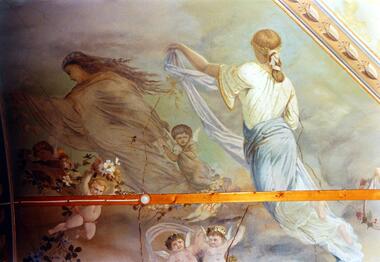
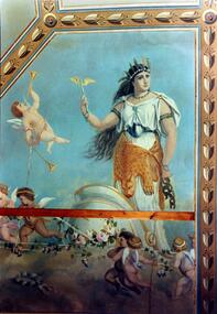
Photograph - Ceiling fresco, Ballroom, ‘Southesk’, Cotham Road, Stewart West, 1970
Colour enlargement of a photograph (slide) of Southesk (formerly Ordsall) in Cotham Road, Kew (demolished 1970).The ceilings of and architraves of Ordsall were painted by artists employed by the decorating company, Cullis Hill & Co. The frescos, of which fragments survive, were some of the most important murals used as elements of interior decoration in Melbourne during the Boom Period of the 1880s. These photographs were taken immediately prior to the demolition of the house, and are the best examples of the murals.Notwithstanding its grand Italianate façade, the most important aspect of Southesk (formerly ‘Ordsall’) were the murals in the front two rooms. An article in the Melbourne Argus in 1882 records that Mr Vandenbrandt and Signor Rizzi created these under the supervision of Cullis Hill. This fresco from the ceiling of the ballroom depicts ‘Night, represented by a female figure in a diaphanous garment, skirted with flowers, wafted before the approaching dawn into space illuminated by the moonlight, and peopled by the fairies, is a striking picture. Flying with her are an attendant Cupid bearing an artificial light, and a tired little votary of Bacchus with a reversed wine-pitcher and goblet’.david carnegie, john halfey, southesk - cotham road - kew (vic), ordsall - cotham road - kew (vic) -
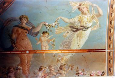 Kew Historical Society Inc
Photograph - Ceiling fresco, Ballroom, ‘Southesk’, Cotham Road, Stewart West, 1970
Colour enlargement of a photograph (slide) of Southesk (formerly Ordsall) in Cotham Road, Kew (demolished 1970).The ceilings of and architraves of Ordsall were painted by artists employed by the decorating company, Cullis Hill & Co. The frescos, of which fragments survive, were some of the most important murals used as elements of interior decoration in Melbourne during the Boom Period of the 1880s. These photographs were taken immediately prior to the demolition of the house, and are the best examples of the murals.The most significant decorative aspects of Southesk (formerly ‘Ordsall’) were the murals in the front two rooms. An article in the Melbourne Argus in 1882 records that Mr Vandenbrandt and Signor Rizzi created these under the supervision of Cullis Hill. This fresco from the ceiling of the ballroom is believed to depict two of the Seasons. Signor Rizzi was a renowned painter of flowers. He is credited with painting these parts of the murals. Examples of his floral paintings can still be seen at Villa Alba in Walmer Street.david carnegie, john halfey, southesk - cotham road - kew (vic), ordsall - cotham road - kew (vic) -
 Kew Historical Society Inc
Photograph - Ceiling fresco, Ballroom, ‘Southesk’, Cotham Road, Stewart West, 1970
Colour enlargement of a photograph (slide) of Southesk (formerly Ordsall) in Cotham Road, Kew (demolished 1970).The ceilings of and architraves of Ordsall were painted by artists employed by the decorating company, Cullis Hill & Co. The frescos, of which fragments survive, were some of the most important murals used as elements of interior decoration in Melbourne during the Boom Period of the 1880s. These photographs were taken immediately prior to the demolition of the house, and are the best examples of the murals.The most significant decorative aspects of Southesk (formerly ‘Ordsall’) were the murals in the front two rooms. An article in the Melbourne Argus in 1882 records that Mr Vandenbrandt and Signor Rizzi created these under the supervision of Cullis Hill. This fresco from the ceiling of the ballroom is believed to depict ‘Africa’. The article records that: ‘Notwithstanding the large size of the drawings they are often marked by delicate touches, and a minuteness of detail in evident sympathy with nature. The figures have grace, life and animation and the skillful shading of the colours used — chiefly amber, gold, light blue, green, light fawn and brown – is in harmony with the quiet tone of the general furnishing of the rooms.’david carnegie, john halfey, southesk - cotham road - kew (vic), ordsall - cotham road - kew (vic) -
 Kew Historical Society Inc
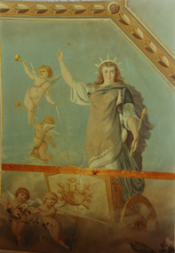
Photograph - Ceiling fresco, Ballroom, ‘Southesk’, Cotham Road, Stewart West, 1970
Colour enlargement of a photograph (slide) of Southesk (formerly Ordsall) in Cotham Road, Kew (demolished 1970).The ceilings of and architraves of Ordsall were painted by artists employed by the decorating company, Cullis Hill & Co. The frescos, of which fragments survive, were some of the most important murals used as elements of interior decoration in Melbourne during the Boom Period of the 1880s. These photographs were taken immediately prior to the demolition of the house, and are the best examples of the murals.The most significant decorative aspects of Southesk (formerly ‘Ordsall’) were the murals in the front two rooms. An article in the Melbourne Argus in 1882 records that Mr Vandenbrandt and Signor Rizzi created these under the supervision of Cullis Hill. This fresco from the ceiling of the ballroom is believed to depict one of the ‘boldly drawn four great geographical divisions of the Earth’. The crowned woman, believed to represent Europe, stands aloft in a chariot drawn by cherubs holding garlands of flowers.david carnegie, john halfey, southesk - cotham road - kew (vic), ordsall - cotham road - kew (vic) -
 Kew Historical Society Inc
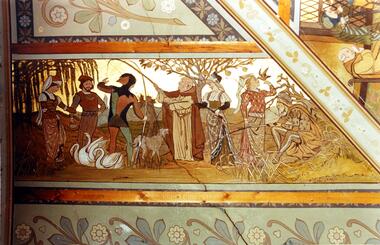
Photograph - Ceiling fresco, Drawingroom, ‘Southesk’, Cotham Road, Stewart West, 1970
Colour enlargement of a photograph (slide) of Southesk (formerly Ordsall) in Cotham Road, Kew (demolished 1970).The ceilings of and architraves of Ordsall were painted by artists employed by the decorating company, Cullis Hill & Co. The frescos, of which fragments survive, were some of the most important murals used as elements of interior decoration in Melbourne during the Boom Period of the 1880s. These photographs were taken immediately prior to the demolition of the house, and are the best examples of the murals.The most significant decorative aspects of Southesk (formerly ‘Ordsall’) were the murals in the front two rooms. An article in the Melbourne Argus in 1882 records that Mr Vandenbrandt and Signor Rizzi created these under the supervision of Cullis Hill. This fresco from the ceiling of the drawingroom was described by the reporter as ‘done in the quaint old 14th century style’. This section depicts ‘out-door sports. The fishing-lines of the jester and the almoner have become entangled, and a large wolf-dog seems disposed to arbitrate in the difficulty, while a party of young men and maidens are angling, feeding swans, or training hawks for a future day’s sport.’david carnegie, john halfey, southesk - cotham road - kew (vic), ordsall - cotham road - kew (vic) -
 Kew Historical Society Inc
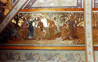
Photograph - Ceiling fresco, Drawingroom, ‘Southesk’, Cotham Road, Stewart West, 1970
Colour enlargement of a photograph (slide) of Southesk (formerly Ordsall) in Cotham Road, Kew (demolished 1970).The ceilings of and architraves of Ordsall were painted by artists employed by the decorating company, Cullis Hill & Co. The frescos, of which fragments survive, were some of the most important murals used as elements of interior decoration in Melbourne during the Boom Period of the 1880s. These photographs were taken immediately prior to the demolition of the house, and are the best examples of the murals.The most significant decorative aspects of Southesk (formerly ‘Ordsall’) were the murals in the front two rooms. An article in the Melbourne Argus in 1882 records that Mr Vandenbrandt and Signor Rizzi created these under the supervision of Cullis Hill. This fresco from the ceiling of the drawingroom was described by the reporter as ‘done in the quaint old 14th century style … The second panel represents a hawking party. The ladies hold aloft the natural perches for their falcons. The men, seated in picturesque variety of attitude, hold their cross-bows, and a boy is relieving a heron from an arrow which has pierced its bosom.’david carnegie, john halfey, southesk - cotham road - kew (vic), ordsall - cotham road - kew (vic) -
 Kew Historical Society Inc
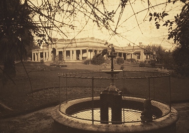
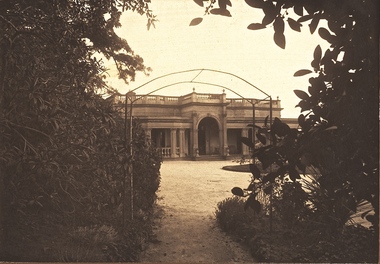
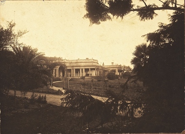
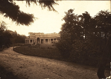
Photograph - 'Southesk' (formerly 'Ordsall'), Cotham Road, 1920s
Ordsall was originally built for John Halfey, second Chairman of Kew, and sold after his death to the Carnegie family who renamed it ‘South Esk'. The Carnegie family mounted a defence of their property when the City of Kew sought to compulsorily acquire the site for a new town hall in the 1930s. The house and land were later acquired by Council in 1947 and demolished in 1970. The present Kew Library and the former Council Offices (now owned by Trinity Grammar) are located on the site.One of the earliest photographs of 'Southesk' and its gardens. The house was of statewide significance because of its historical association with John Halfey. It was artistically significant due to its elaborate interiors, decorated by Cullis Hill & Co in the 1880s. Sepia photograph mounted on brown card of "Southesk' (formerly known as 'Ordsall'). The single-storey Italianate facade of the house can be seen surrounded by an extensive garden. The point-of-view of the camera is from Cotham Road.john halfey, david carnegie, southesk - south esk - ordsall -
 Kew Historical Society Inc
Photograph - 'Southesk' (formerly 'Ordsall'), Cotham Road, 1920s
Ordsall was originally built for John Halfey, second Chairman of Kew, and sold after his death to the Carnegie family who renamed it ‘South Esk'. The Carnegie family mounted a defence of their property when the City of Kew sought to compulsorily acquire it as the site for a new town hall in the 1930s. The house and land were later acquired by Council in 1947 and demolished in 1970. The present Kew Library and the former Council Offices (now owned by Trinity Grammar) are located on the site.One of the earliest photographs of 'Southesk' and its gardens. The house was of statewide significance because of its historical association with John Halfey. It was artistically significant due to its elaborate interiors, decorated by Cullis Hill & Co in the 1880s. Sepia photograph mounted on brown card of "Southesk' (formerly known as 'Ordsall'). The single-storey Italianate facade of the house can be seen surrounded by an extensive garden. The point-of-view of the camera is from Cotham Road.john halfey, david carnegie, southesk - south esk - ordsall -
 Kew Historical Society Inc
Photograph - 'Southesk' (formerly 'Ordsall'), Cotham Road, 1920s
Ordsall was originally built for John Halfey, second Chairman of Kew, and sold after his death to the Carnegie family who renamed it ‘South Esk'. The Carnegie family mounted a defence of their property when the City of Kew sought to compulsorily acquire it as the site for a new town hall in the 1930s. The house and land was later acquired by Council in 1947 and demolished in 1970. The present Kew Library and the former Council Offices (now owned by Trinity Grammar) are located on the site.One of the earliest photographs of 'Southesk' and its gardens. The house was of statewide significance because of its historical association with John Halfey. It was artistically significant due to its elaborate interiors, decorated by Cullis Hill & Co in the 1880s. Sepia photograph mounted on brown card of "Southesk' (formerly known as 'Ordsall'). The single-storey Italianate facade of the house can be seen surrounded by an extensive garden. The point-of-view of the camera is from Cotham Road.john halfey, david carnegie, southesk - south esk - ordsall -
 Kew Historical Society Inc
Photograph - 'Southesk' (formerly 'Ordsall'), Cotham Road, 1920s
Ordsall was originally built for John Halfey, second Chairman of Kew, and sold after his death to the Carnegie family who renamed it ‘South Esk'. The Carnegie family mounted a defence of their property when the City of Kew sought to compulsorily acquire it as the site for a new town hall in the 1930s. The house and land were later acquired by Council in 1947 and demolished in 1970. The present Kew Library and the former Council Offices (now owned by Trinity Grammar) are located on the site.One of the earliest photographs of 'Southesk' and its gardens. The house was of statewide significance because of its historical association with John Halfey. It was artistically significant due to its elaborate interiors, decorated by Cullis Hill & Co in the 1880s. Sepia photograph mounted on brown card of "Southesk' (formerly known as 'Ordsall'). The single-storey Italianate facade of the house can be seen surrounded by an extensive garden. The point-of-view of the camera is from Cotham Road.david carnegie, john halfey, southesk - south esk - ordsall -
 Kew Historical Society Inc
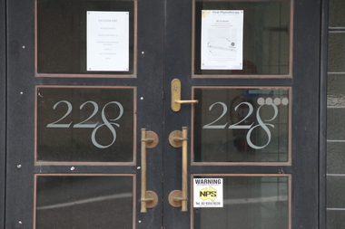
Photograph - Photographs (series), Richard Bowen, Sunninghill, 228 Cotham Road, 07/02/2020
'Sunninghill' at 228 Cotham Road (Kew) is an historically significant building due to its associations with Joseph Thomas (Bland) Holt (1851-1942), theatre entrepreneur and actor who lived at the house following his retirement in 1909. Sunninghill (aka Sunning Hill) was one of his residences in Victoria (also 'The Anchorage' at Sorrento). Following Holt's death at Sunninghill on 28 June 1942, the house was left to his wife. After her death the house was bequeathed to Lucy Coppin, daughter of George Coppin. The 'Shakespeare Window' in the State Library of Victoria was at one stage installed in the house. References 'Death of Mr Bland Holt: Great exponent of melodrama', The Argus, 30 June 1942, p. 3. Shoesmith D, 'Holt, Joseph Thomas (Bland) (1851-1942)', Australian Dictionary of Biography, Vol 4, 1972. 'The Shakespeare Window', State Library of Victoria website.Exterior photographs (digital) of Sunninghill, 228 Cotham Road, Kew VIC 3101. sunninghill - 228 cotham road - kew (vic), joseph thomas (bland) holt, lucy coppin -
Kew Historical Society Inc
Journal, Kewriosity : July 1991
Not blowing in the wind [recycling paper] / p1. Completing the picture [Disability access at The Alexandra Gardens] / p1. Business seminar / p1. Manna from the heavens [water consumption and water rates] / p1. Willsmere go-ahead [Jennings development] / p1. Diary dates for July / p2. Winter: a good time for bushwalking [Kew Bushwalkers Club] / p2. Kinder's 40th [J.J. McMahon Memorial Kindergarten] / p2. Study Camp / p2. Commentary / Cr Daryl Oldaker / p3. Chief Executive's Column [amalgamation of local government entities] / Malcolm Hutchinson p3. Your chance to stand [Council elections] / p4. Letter to the editor [Kew Junction] / Tim Warmington p4. Looking into windows [Property revaluations] / p4. Mayor opens park [bicycle path in Outer Circle Linear Park] / p4. Gisborne passes this motion [Dog Act] / p4. Traffic Management updates - Speed cameras? [Area 6, Area 7, Area 10] / p5. Nit picking again [new head lice brochure] / p5. Concerned about possums? / p5. Your tobacco taxes at work / p5. Taste it ... you'll like it [Beatrix Potter] / p6. Literacy programmes [Kew Community House programmes] / p6. Royal Guide Dogs needs your help / p6. Youth Leadership course / p6. Rock bottom prices [petrol price competition] / p7. Arthritis AGM [Kew Arthritis Self Help Group] / p7. Cheque for Blind Mission [fundraising for Christian Blind Mission International by Carey Grammar School] / p7. Live comedy at Hartwell [Hartwell Players] / p8. Peel Street Anniversary [Sir Robert Peel PM] / p8. Holeproof factory future [Holeproof Hosiery plant in Surry Hills] / p8. What topics arose? [architectural and garden roses] / p8.Kewriosity was a local newsletter combining Kew Council and community news. It was published between November 1983 and June 1994, replacing an earlier Kewriosity [broad] Sheet (1979-84). In producing Kewriosity, Council aimed to provide a range of interesting and informative articles covering its deliberations and decision making, together with items of general interest and importance to the Kew community and information not generally available through daily media outlets.non-fictionNot blowing in the wind [recycling paper] / p1. Completing the picture [Disability access at The Alexandra Gardens] / p1. Business seminar / p1. Manna from the heavens [water consumption and water rates] / p1. Willsmere go-ahead [Jennings development] / p1. Diary dates for July / p2. Winter: a good time for bushwalking [Kew Bushwalkers Club] / p2. Kinder's 40th [J.J. McMahon Memorial Kindergarten] / p2. Study Camp / p2. Commentary / Cr Daryl Oldaker / p3. Chief Executive's Column [amalgamation of local government entities] / Malcolm Hutchinson p3. Your chance to stand [Council elections] / p4. Letter to the editor [Kew Junction] / Tim Warmington p4. Looking into windows [Property revaluations] / p4. Mayor opens park [bicycle path in Outer Circle Linear Park] / p4. Gisborne passes this motion [Dog Act] / p4. Traffic Management updates - Speed cameras? [Area 6, Area 7, Area 10] / p5. Nit picking again [new head lice brochure] / p5. Concerned about possums? / p5. Your tobacco taxes at work / p5. Taste it ... you'll like it [Beatrix Potter] / p6. Literacy programmes [Kew Community House programmes] / p6. Royal Guide Dogs needs your help / p6. Youth Leadership course / p6. Rock bottom prices [petrol price competition] / p7. Arthritis AGM [Kew Arthritis Self Help Group] / p7. Cheque for Blind Mission [fundraising for Christian Blind Mission International by Carey Grammar School] / p7. Live comedy at Hartwell [Hartwell Players] / p8. Peel Street Anniversary [Sir Robert Peel PM] / p8. Holeproof factory future [Holeproof Hosiery plant in Surry Hills] / p8. What topics arose? [architectural and garden roses] / p8.publications -- city of kew (vic.), kewriosity, council newsletters, community newsletters