Showing 10434 items
matching sites
-
 Stawell Historical Society Inc
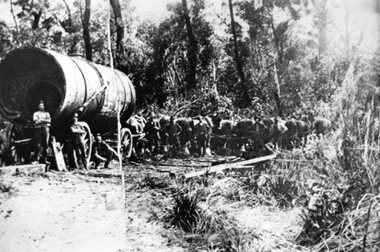
Photograph, Large Boiler being transported by Horses from the Magdala Mine Site in Stawell to the Heatherlie Quarry
Large Boiler being transported by Horses probably in location of Fyans Creek. Boiler being transported from the Magdala Mine Site in Stawell to the Heatherlie Quarry to replace unserviceable Boiler.stawell industry mining -
 National Wool Museum
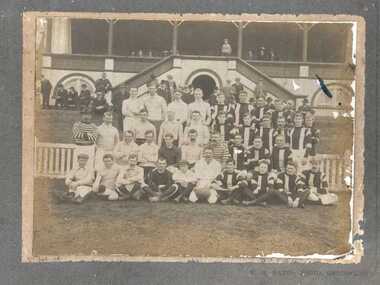
Photograph, Footballers posing in team photograph
Photo possibly depicts a Dalgety's Football team from 1909. It was found in the kitchen of Dalgety North, the NWMs old off site store (now part of Deakin University) in 1989.27 AUG. '09 W.H. WATTS, PHOTO, GEELONG.wool stores staff, sport, wool stores - staff -
 National Wool Museum
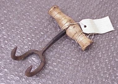
Bale Hook
Found by RC and J Lewis in laneway running south from Western Beach Road between Dalgety North building and Dennys Lachelles building (old Corio Tannery site). -
 Hume City Civic Collection
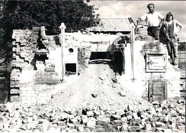
Photograph, 1970s
The Sunbury bakery which was in O'Shanassy Street was demolished in the 1970s to make way for newer retail development. Bakery Walk off O'Shanassy Street defines the vicinity of the former bakery site.A black and white photograph of a demolished bakery. Two men standing above the oven on the RHS with a heap of rubble in the foreground.bakeries, bread making, bakery walk, george evans collection -
 Hume City Civic Collection
Photograph, Early 1990's
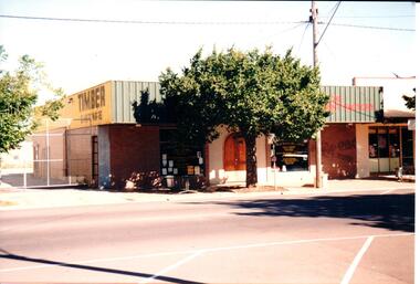
The building suppliers and timber yard has been demolished and a Centrelink Office and car park area has been built on the site. The adjacent shop is now a Youth Resource Centre.A coloured photograph of part of a streetscape on the east side of Evans Street featuring the timber supply yard and 3 other shops. A plane tree has been planted at the edge of the footpath and there are high cyclone gates into the timber yard.building suppliers, timber yards, shopping centres, evans street, george evans collection -
 Sunbury Family History and Heritage Society Inc.
Photograph, C 1930s
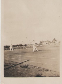
The men were playing tennis on courts that were sited on railway land behind the post office between Evans Street and the railway line in Sunbury. The house in the background was in Evans Street From the early days of European settlement in Sunbury, various sporting groups such as tennis, cricket and football, were established in Sunbury.A sepia photograph with a white border of two men playing tennis. There vis a house in the middle distance.tennis, tennis courts, evans street -
 Sunbury Family History and Heritage Society Inc.
Photograph, c 1920s
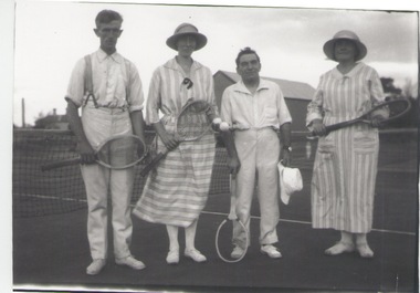
The four people had gathered to play a tennis match of the courts which were sited in Evans Street, which is now occupied by then Sunbury Shopping Centre adjacent to the railway line.A black and white photograph of two ladies and two men standing in front of a net on a tennis court.tennis, tennis courts -
 Halls Gap & Grampians Historical Society
Postcard - B/W, C 1960
Hotel Bellfield was totally destroyed by fire in 1969 Lou DeClifford was owner at that time and did not renew the hotel licence but later built a motel known as Grampians Motel on the same site.Guest House with car in foregroundThe Rose Series P 10079accommodation, hotels, bellfield -
 Halls Gap & Grampians Historical Society
Photograph - B/W
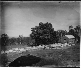
The photos show the Russell bee-hives at Roses Gap. The tree near the hut is the present site of Chinaman Lodge home. One of the copies is a transparency located at No 243 in the slide box.The photos show a group of bee-hives lined up in front of a timber shed. The hives and shed are in a clearing. There is a large tree near the shed and the clearing is edged with thick bush in the background. The two copies are of two photos taken at slightly different angles and distances from the shed.misc industries, bee-keeping, scenery, cherrypool -
 Halls Gap & Grampians Historical Society
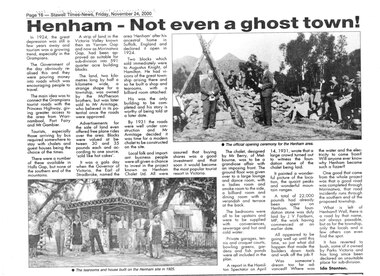
Newspaper - B/W, C 24/11/2000
An article describing the Henham Township project as well as the Knight Family Tearooms built on the Henham site in 1925. For further info see "Victoria's Wonderland" pp 93-95, 103.A newpaper article from "The Stawell Times" , "Halls Gap Extra" Supplement of 24 November 2000, page 16, entitled Henham v- Not even a ghost town!townships, henham -
 Phillip Island and District Historical Society Inc.
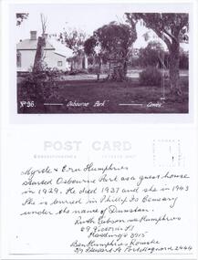
Photograph - Post Card, Osborne Park Guest House Phillip Island, 1930's
Black & White photograph of a postcard. Postcard owned by Jan Stewart, Jan & John Stewart operated Bayside Caravan Park, 7 Beach Street, Cowes. This was the site of "Osbourne Park".Black & Whte photograph of a postcard, front and back. Osbourne Park Guest House in Beach Street, Cowes Front: No. 96. "Osbourne Park" - Cowes. Back: Myrtle & Ern Humphries started Osbourne Park as a guest house in 1929. He dies 1937 and she in 1943. She is buried in Phillip Is Cemetery under the name of Dunstan. Ruth Gibson nee Humphries, 69 Victoria Street, Hastings 3915. Ben Humphries Romake, 5/6 Stewart St., Port Macquarie 2444.osbourne park guesthouse phillip island, guesthouses cowes phillip island, myrtle & ern humphries, elaine alexander -
 Galen Catholic College
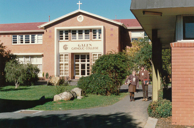
Galen Catholic College Buildings & Grounds, 1989
This series of photos was taken in 1989 at the present College Street site. After 1989, all year levels, from Year 7 upwards were situated on the College Street campus.galen catholic college, galen college -
 Eltham District Historical Society Inc
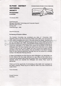
Document - Property Binder, Library Place, Eltham
1. Letter: Russell Yeoman, EDHS to Geoff Edmonds, Nillumbik Shire Council, 10 January 2003 re naming of the roads surrounding the former Eltham Shire Office site.eltham, eltham district historical society, geoff edmonds, library place, nillumbik shire council, russell yeoman, shillinglaw trees -
 Whittlesea Historical Society Inc.
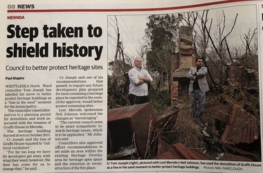
Newspaper - Newspaper clipping, Whittlesea Leader, Step taken to shield history, 17 Apr 2018
Published Whittlesea Leader, 17 Apr. 2018. Step taken to shield history. Council to better protect heritage sites after the loss of Graff's house in Mernda was destroyed by fire.Newsprintwhittlesea leader, mernda, graff house, graff's house mernda -
 Melton City Libraries
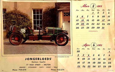
Archive, Jongebloed's Hardware Supplies Calendar, 1972
Bakery Square was the site of 19thCentury Jongebloed family bakery, grocery shops and residence demolished 1970 and later hardware shop erected c 1960. Stables at rear to McKenzie StreetCalendar from the hardware storelocal identities -
 Stawell Historical Society Inc
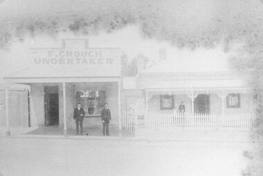
Photograph, Mr Frank Crouch -- Undertaker, established 1862 in Main Street Stawell with private residence on site still being used
F. Crouch (Established 1862) Main Street and private residence on site still being used. The business premises are built of bricks brought from the original building in Stawell West.stawell -
 Stawell Historical Society Inc
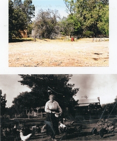
Photograph, Kanya Farm with Family Members & Buildings
House sites in colour at top. 2015 Bottom Houses with Eliza Thornton wife of Charles. Left hand side house was re-located to Ligar Street Stawell in 1900's. -
 Bendigo Military Museum
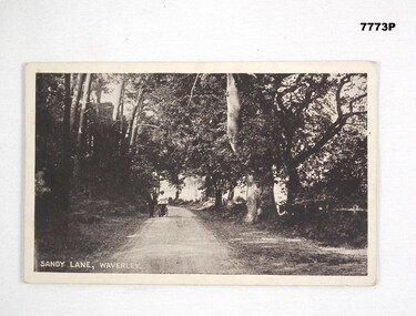
Postcard - POSTCARD, WAVERLEY, U.K, A. Cummins Postcard Series, cWW1
'R. H. Baron' visited Waverley during leave. His Uncle and Florrie lived near here. Waverley was the site of a battle during the First Baron's War 1215 - 1217.Photograph of a couple walking down a lane. Lane lined with trees.Sandy Lane, Waverley. Handwritten in pencil on back 'Letter to R.H. Baron's brother from Baron - no date.'robert h. baron, cooper collection, postcard, waverley uk -
 Lakes Entrance Regional Historical Society (operating as Lakes Entrance History Centre & Museum)
Photograph, M Holding, 2006
Previous building on site Dr. George Rechelmann residence and surgery, Bulmers Booking Office, Ivan Ivenson Engineering 1887 - 1888 Building moved to Ostlers Road 1980 cColour photograph of business on corner of Bulmer Street and Esplanade comprising Sallys Restaurant above Charmwood Antiques and Cafe with Florist and Gift Shop next door Lakes Entrance Victoriabusinesses -
 Lakes Entrance Regional Historical Society (operating as Lakes Entrance History Centre & Museum)
Photograph, 2000
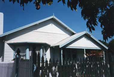
Freeman family home originally situated on south side of Gray Street, western corner of lane. Relocated to Bulmer Street after Arceris bought site and extended the general store.Colour photograph of a timber dwelling at 10 Bulmer Street, which has gable roof, bay window in one front room, gable roof veranda over front entry. Timber picket fence. Lakes Entrance Victoriahouses, heritage study -
 Lakes Entrance Regional Historical Society (operating as Lakes Entrance History Centre & Museum)
Photograph, Holding M, 2009
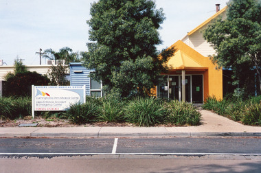
Date made September 2009|Site / building was originally (games room) part of caravan park|Also one other colour photograph closer view of front entrance doorway.Colour photograph of the front entry to Cunninghame Arm Medical Centre at 8 Whiters Street. Appears to be brick or concrete slab facade painted bright yellow. Information sign in native plant garden, brick pathways. Lakes Entrance Victoriaentertainment, transport -
 Lakes Entrance Regional Historical Society (operating as Lakes Entrance History Centre & Museum)
Photograph, 1999
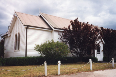
Original Church built late 1880's on John King's property, moved to present site 1897. Church Hall built after WWI by voluntary labour, later enlarged.Colour photograph of St John's Anglican Church, Metung, showing a timber English Gothic style church with gable roofs over nave, chancel, porches etc. Lancet windows with peripheral glazing bars. Turned finials on roofs including belfrey roof. Bollard and chain fence. Metung Victoriareligion, halls -
 Federation University Historical Collection
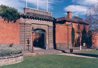
Colour photograph, Ballarat Courier Photographer, Former Ballarat Gaol Gates, 09-06-1997
The main gate to the former Gaol is a monumental work. The arch keystone facing Lydiard Street is beautifully executed. The gates and the iron lacework over the top are distinctive.The arch under the flyover is also distinctive; the basalt keystone appears to have been cut from one single block of stone. Most of the gaol has been demolished to allow the School of Mines Ballarat to expand onto the site. The remaining structures at the site include the main gate, warden's residence and governor's residence. These buildings are now used by Federation University.The main gate to the former Gaol is a monumental work. The arch keystone facing Lydiard Street is beautifully executed. The gates and the iron lacework over the top are distinctive.The arch under the flyover is also distinctive; the basalt keystone appears to have been cut from one single block of stone. gate, gaol, arch keystone, lydiard street, iron lacework, flyover, stone, basalt, ballarat school of minesfederation university, warden's residence, governor's residence -
 Federation University Historical Collection
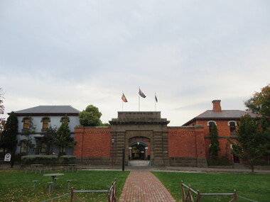
Photograph - Colour photograph, Former Ballarat Gaol Gates, 24/04/2017
The main gate to the former Gaol is a monumental work. The arch keystone facing Lydiard Street is beautifully executed. The gates and the iron lacework over the top are distinctive.The arch under the flyover is also distinctive; the basalt keystone appears to have been cut from one single block of stone. Most of the gaol has been demolished to allow the School of Mines Ballarat to expand onto the site. The remaining structures at the site include the main gate, warden's residence and governor's residence. These buildings are now used by Federation University.The main gate to the former Gaol is a monumental work. The arch keystone facing Lydiard Street is beautifully executed. The gates and the iron lacework over the top are distinctive.The arch under the flyover is also distinctive; the basalt keystone appears to have been cut from one single block of stone. gate, gaol, arch keystone, lydiard street, iron lacework, flyover, stone, basalt, warden's residence, governor's residence, ballarat school of mines, federation university, former ballarat gaol -
 Kiewa Valley Historical Society
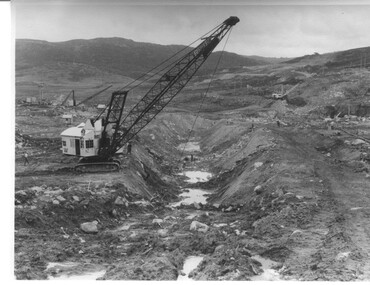
Photograph Rocky Valley Dam Excavations, Rocky Valley Dam Wall Excavation, c1947-48
Work commenced at Rocky Valley Dam site in early 1947 and proceeded until May. Resumed work in October after the winter and a camp for the accommodation of workmen was commenced at this time. Work continued in 1948 with the establishment of work facilities, including the erection of two large excavators. At the dam site the river was diverted through a temporary pipeline. Work proceeded in the summer months with the placing of concrete in the foundations and earth and rock fill for the construction of the wall. Rocky Valley and associated spillway and outlet works were completed in March, 1959. A very good representation of the type of machinery available in the 1940's used for excavation of the dam and the construction of the dam wall.Black and white photograph of Rocky Valley Dam wall under construction. There are at least three cranes plus workmen in the photo. This is taken from the Heathey's Spur side of the dam wall looking back toward Sun Valley.Hand written on back of photograph "Rocky Valley Dam Wall Excavation" in blue ink.rocky valley, dam, wall, machinery -
 Glen Eira City Council History and Heritage Collection
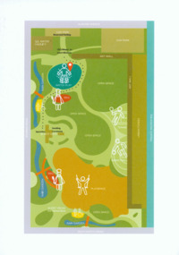
Event Run-sheet and Map, "Booran Reserve Official Opening"
This run-sheet and map were used for the opening of Booran Reserve at the corner of Booran and Glenhuntly Roads on Tuesday 11 April 2017. The Reserve was officially opened by the Mayor, Cr. Mary Delahunty and The Hon. Philip Dalidakis, MP, Minister for Innovation. The run-sheet contains information about the Order of Proceedings of the opening ceremony. The map notes the locations of reserved parking, the route taken by Mayor Mary Delahunty and Minister Philip Dalidakis through the Reserve, and the speech and smoking ceremony site. The site of the Reserve was previously the Caulfield Service Reservoir.Black and white printed run-sheet, and green, teal, red, yellow, blue and khaki colour printed map -
![Congregational Church, Walpole Street [Kew], 1977](/media/collectors/550653872162f11fb04854aa/items/58ce2f27d0ce2909d88dffec/item-media/58cf5dbbd0ce9d3314c36111/item-fit-380x285.jpg) Kew Historical Society Inc
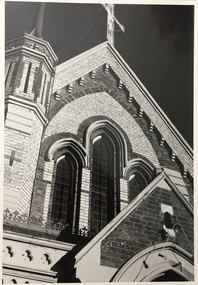
Kew Historical Society IncPhotograph, Unknown, Congregational Church, Walpole Street, 1977
The Congregational Church was built on the site of the first church in Kew. This church, the second on the site, was designed by the Kew architect Charles Vickers and opened in 1860. The distinctive polychrome brick façade designed by Vickers contrasted with the style that he employed for other churches he designed during this period; they were usually constructed in bluestone. In the 1960s, a new ministry saw the erection of a neon cross at the apex of the church. The illuminated cross could be seen from Church Street, Hawthorn. The church was later to be demolished, and the land sold for the construction of modern villas. The Kew Historical Society's Pictures Collection is comprised of photographs, postcards and original works of art. The photographs include original (mainly) images dating from the 1870s to the present. A number of these photographs derive from the former City of Kew's Civic Collection while others are the work of amateur and professional photographers. Most of the images in the collection depict people, places and objects within the suburbs of Kew and Kew East. Other photographs depict other locations in Melbourne and Victoria. A number of the photographs are of statewide and/or national significance.Congregational Church, Walpole Street, Kew, 1977 (now demolished). View of the polychrome facade facing Walpole Street. The use of polychrome brick by Alfred Purchas (the second architect) reflects his preference for this architectural style, such as in his design for Tarring (now Ruyton Girls' School)Inscriptions on reverse: "KH-99. Congregational Church Walpole St Kew. Built 1854. Now amalgamated with United Churches 1977."congregational church, walpole street (kew), charles vickers -
 Kew Historical Society Inc
Photograph, Congregational Church, Walpole Street, 1977
The Congregational Church was built on the site of the first church in Kew. This church, the second on the site, was designed by the Kew architect Charles Vickers and opened in 1860. The distinctive polychrome brick façade designed by Vickers contrasted with the style that he employed for other churches he designed during this period; they were usually constructed in bluestone. In the 1960s, a new ministry saw the erection of a neon cross at the apex of the church. The illuminated cross could be seen from Church Street, Hawthorn. The church was later to be demolished, and the land sold for the construction of modern villas.Congregational Church, Walpole Street, Kew, 1977 (now demolished). View of the polychrome facade facing Walpole Street. The use of polychrome brick by Alfred Purchas (the second architect) reflects his preference for this architectural style, such as in his design for Tarring (now Ruyton Girls' School) Inscriptions on reverse: "K.H.701. Congregational Church Walpole St Kew. First church in Kew. Now amalgamated with the United Churches."congregational church, walpole street (kew), charles vickers -
 Warrnambool and District Historical Society Inc.
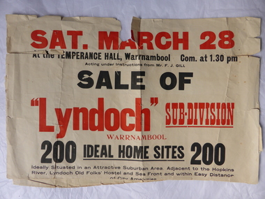
Poster, Lyndoch Sub-Division
This is a poster advertising the sale of the Lyndoch sub-division in Warrnambool with the sale of 200 housing sites. The sale took place about 1958 with the land sold by Frederick Gill, a Warrnambool jeweller. The land was previously owned by George Rolfe who had acquired the land near the mouth of the Hopkins River in the 1880s and named the property ‘Lyndoch’. He bought the surrounding land at a later time. This sub-division came to be known as the Gill Estate. It was a valuable site as many of the allotments fronted the sea and others were adjacent to the Hopkins River. This poster, although tattered, is of interest as it has many details of the Gill Estate sub-division and will be useful to researchers. This is a cream-coloured paper poster with black and red printing. The poster has a small map in a circle shape showing the location of the streets and a larger map section showing the streets and the allotments to be sold. The poster is in two pieces and the edges are torn and, in some sections, missing. The streets map has some pencil annotations. history of warrnambool, lyndoch, warrnambool, george rolfe, frederick gill -
 Eltham District Historical Society Inc
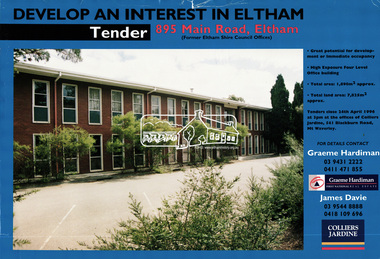
Document, Tender Documents for purchase of Former Eltham Shire Offices 895 Main Road, Eltham, April 1996, 1996
Graeme Hardiman Real Estate Prepared for Nillumbik Shire Council Maddock Lonie & Chisholm, 140 William Street, Melbourne Tenders closed at 3.00pm on 24 April 1996 Whilst the sale of the former Shire Office site went through and the Shire Commissioners approved the demolition of the building several months later in the year, ongoing community protests and objections eventually led to the reversal of the sale. Despite several further attempts to sell the site and community protests as recent as 2019, the vacant land remains in Council ownership.89 A4 pages; 1 x glossy paper with photo and 88 x photocopied pageseltham shire office, graeme hardiman first national real estate, maddock lonie & chisholm, nillumbik shire council, real estate, tenders