Showing 7341 items
matching shop
-
 Gippsland Vehicle Collection
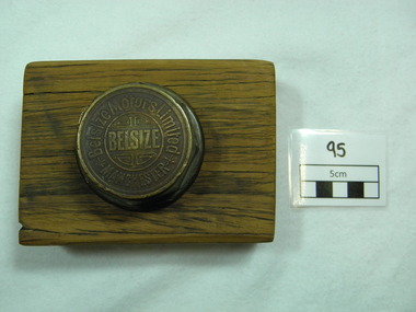
Belsize Wheel Nut, Belsize Motors Limited, Early twentieth century
This wheel nut was found in a long abandoned car yard (Gino's) located in Maffra, Gippsland, and it belonged to a car from the Belsize Motorcar Company (England). A then local man, Frank Straw who found the wheel nut (in 1968) is the grandson of John Hughes. The latter did an apprenticeship as a coachbuilder with the Belsize Company of Manchester, England. He then emigrated (with his wife) to Australia in 1910 and settling in Maffra opened a coachbuilder's shop . He told his grandson that seven Belsize cars came to Australia and that one made its' way to Maffra where John Hughes worked on it at his shop. John Hughes). Old gold coloured Belsize Wheel Nut (metal) and mounted on a rectangular block of wood.Wheel nut is inscribed as follows: BELSIZE in middle of nut surrounded by four (one in each corner) decoration emblems (as seen in photo) surrounded by a gold circle. Around the outside of the circle are the words Belsize Motors Limited -an asterisk at the beginning and end of the company name. Outside the circle at the bottom is the word MANCHESTER. Around the edge of the top of the wheel nut are two gold line circles. -
 Melbourne Tram Museum
Newspaper - CBD News Feb. 2024, hyperlocal news, "Heritage-priced coffee from a heritage tram", Feb. 2024
Set of two items from the Hyperlocal published newspaper title CBD News containing two relevant tramway items: 1 - page 2 - "Council convenes key groups to help fix the southern end of Elizabeth St" - to address user behavior issues around the tram terminus and food shops 2 - page 3 - "Heritage-priced coffee from a heritage tram" - about the use of the former SW5 class 764 tram as a coffee shop at the William Angliss buildings in La Trobe St Melbourne. Has photos on the front page and page 3.Yields information about the use of repurposed tram by the William Angliss Institute.Newspaper - extract from the Feb. 2024 issue, No. 105.trams, tram 764, william anglis, elizabeth st terminus, behavior, coffee shops -
 The Beechworth Burke Museum
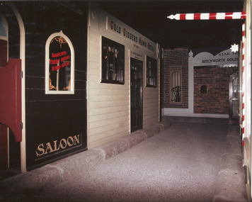
Photograph, c1990
Taken in the 1990's, this photograph depicts a row of shop fronts in the 'Street of Shops' exhibition in the Burke Museum in Beechworth. This exhibition was created and opened in 1979 and was intended to reflect and imitate a historic peirod in the town's past. The time period decpicted is that of the Gold Rush which swept through many Victorian towns from the 1850's onwards. For the town of Beechworth, the gold rush began in 1852, when gold was discovered in Spring Creek, drawing in many new residents seeking to make a fortune and transforming a once remote town into a bustling centre brimming with hope and opportunity. By 1857, the town contained over 200,000 residents and with this, the need for more amenities and intsitutions arose. Multiple churches, banks, schools, shops, hospitals and other essential buildings appearing over the years. The wealth acquired through the gold rush is largely responsible for the vast development of the town and many of its significant buildings which still remain to this day. This photograph also highlights the significance of this type of exhibition, providing a new mode of experiencing and learning about the past. The street depicts the many supporting trades and industries that arose from the mass migration during the gold rush. The creation of the Street of Shops in 1979 was envisioned by Roy Harvey who was the curator at the time, with the intention of recreating an authentic feel to the environment while collecting from the community to accurately portray the multiculturalism that is ingrainded in many towns and communities of Victoria. This photograph contains historical significance as it relates to and portrays an especially important period of time within Beechworth and Victoria's history. The gold rush phenomena ushered in a wave of hope and prosperity for citizens and immigrants alike. It provided many with the opportunity to strike it rich, while the town prospered and grew in many ways. This widespread development that accompanied the gold rush occured throughout Victoria and holds great historical importance when recording the social, economic and communal developments that occured throughout the time period which gave way to the beloved towns and communities we know today. Beechworth itself is acknowledged as Victoria's best-preserved gold mining town and deserves recognition of its significance. it also showcases the great significance of social develpment and globalization that occured throughout the state during this period. Coloured rectangular photograph printed on matte photographic paper and unmounted. Obverse: Dancing every night 8pm-6am [mirror] / Gold Diggers Arms Hotel façade / Star / Beechworth Gold / J. Davidson / Saloon Reverse: 3306 beechworth, burke museum, street of shops, gold rush, indigo shire gold rush, 1850s beechworth, burke museum exhibitions, saloon, gold buyer, hotel, historical streetscape, gold rush immigration -
 Bendigo Historical Society Inc.
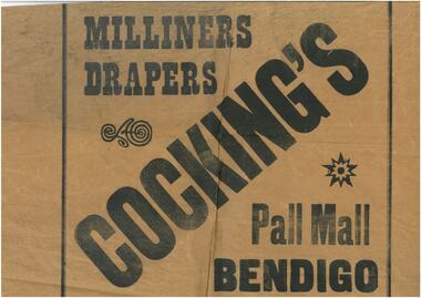
Work on paper - Three samples of wrapping paper (a-Cockings, b-Bennetts Store & c-Beehive stores)
Robert Samuel Valentine Cocking (1882 - 14/5/1945) Born in Bendigo, Val Cocking began hi retail career at Myer Bendigo before opening his own draper shop c. 1912 in the lower block Pall Mall. In 1914 he moved his stock into temporary premises while he renovated his new shop, which combined the former Post Office Hotel and adjacent grocery and stationary shops. The new emporium opened in Aug 1918 selling drapery and soft goods. Mr Cocking was a champion rifle shooter; President of the Bendigo Chamber of Commerce; President of the Sandhurst Football Club for 18 years and President of the Bendigo Cricket Club. Bennetts Hardware shop was in Hargeaves St near the entrance to Allan's Walk in the 1950's. Beehive buildings. This was originally the Sandhust Mining Exchange and as such was the oldest purpose built exchange in Australia and was one of only two in regional Australia. It was initially established in the 1850's to service the miners of the area. It's first double story incarnation as the Bendigo Stock Exchange, contained up to 2000 stockbrokers and 5000 shareholders. In 1871 the building burnt to the ground and the new and current building was completed in 1872. The modern building was designed by Charles Webb, who was also responsible for the Royal Arcade in Melbourne. and features a pitched glass roof similar to the Royal Arcade, Melbourne.Three samples of wrapping paper from a. Cockings, b. Bennetts Store & c. Beehive storeswrapping paper, cockings, bennetts, beehive -
Mission to Seafarers Victoria
Letter - Correspondence, 1948
Quinn CollectionA single sheet of unlined paper folded in half (book-form) to give four pages (0372a) and written on three and a half pages. Letter written on board S.S.Morgenster, Capetown and dated 21/03/48. Blue-lined envelope (0372b). 0372a bears printed 'South-African Marine Corporation' letter-head and company flag. 0372b bears two blue South African stamps on right upper corner and a blue 'Par Avion' label on the left. There is, what appears to be, a shopping list penciled on the backletters-from-abroad, quinn, s.s.morgenster, 1948 -
 Ringwood and District Historical Society
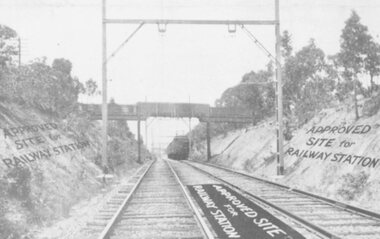
Photograph, Heatherdale Station Estate - 1924. Railway line and Approved Site for Railway Station
View of Railway Line and train, with labelling "Approved Site for Railway Station"Catalogue card reads, "Heatherdale Station Estate - 1924. 12 shop sites and 80 allotments. No deposit and 1 pound per month. 2nd Feb. 1924. J.B. McAlpin, agent. Situated between Heatherdale Rd. and Madden St. The station was erected in 1958." -
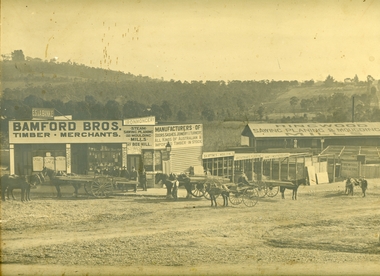 Ringwood and District Historical Society
Photograph, Maroondah Highway Central, Ringwood. Bamford's Timber Yard, 1910
Sepia photographImage shows timber yard with men and horse-drawn vehicle outside building. Warrandyte Road on right leading to Kennedy's orchard. Shop on corner was 'A. Wagner, Hairdresser. Photograph received from a Mr. Harrison, E.S.& A Bank Manager , Frankston. (Peter Paynes photographer). -
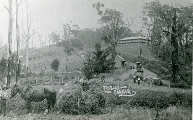 Mt Dandenong & District Historical Society Inc.
Photograph, The Busy Corner, 1907
View of Kalorama gap taken in 1907 showing Eliza Hand outside Beulah Tea Rooms, Briartys Coach, Dodd's Grocery cart and Meat Cutting cart. In foreground Fred Jeeves is standing and Theo Hand on hay. Mountjoy is in the background.This photograph has a detailed inscription on the back handwritten by John Lundy-Clarke in 1974.The Kalorama Gap in 1907. The coach road comes from right behind old stump. The shop was Hand's Beulah Tea Rooms soon to become the Mt Dandenong North Post Office. Big woman in black was Mrs Hand. wagon was Dodd's Grocery cart. "Mountjoy" on hilltop. The wagon with man was the first coach on the mount (Briartys). Small cart was Dodd's meat cutting cart. Horse at sledge was "Blossom" boy at her head was Fred Jeeves. Boy on sledge was Theo hand. Elm trees in centre of picture with Prices sign advertising shop and newsagency above them.mountjoy, beulah tea rooms, fred jeeves, theo hand, dodd's grocery cart, cart, coach, briartys -
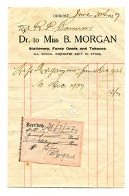 Orbost & District Historical Society
account, 1927
Miss B. Morgan owned a stationery, fancy goods and tobacco shop in Orbost. Robert Pullar Cameron was a Shire Councillor for many years. He married Penuel Hossack and had a family of James, Flora, Penuel and Alex.This item is an example of trhe early 20th century book-keeping of an Orbost business. It is a useful research tool.A white paper account with red lines and black print. Details are hand-written. There is a pink sticker attached. It is from Miss B. Morgan to Mr R. Cameron. account-book-keeping cameron morgan-miss-b. -
 Ballan Shire Historical Society
Photograph - Photograph. Inglis St. Ballan, Inglis Street in Ballan, c 1930/40
Inglis Street of Ballan .circa 1930/40.The photograph is looking East. Parts of the Mechanics Institute and Free Library can be seen, as can the butcher shop, and on the opposite side of the Street the Ballan Hotel and Post and Telegraph office.Black and white photograph of Inglis Street Ballan.Looking East. Photograph is on a cardboard backing with an ornate surround of green and gold. Cars and a truck circa 1930/40 are parked in the street.The word Ballan written on bottom of surround under the photographtelegraph office, car, mechanic institute, butcher shop, delivery truck, 1930 40 cars -
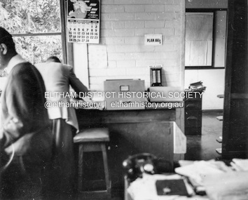 Eltham District Historical Society Inc
Album - Photograph, J.A. McDonald, Garden Hill, Kangaroo Ground, Feb. 1963
Most likley the interior of the Eltham Shire Offices at the corner of Artur Street and Main Road. The calendar is set on February 1963. ERngineering and Planning were also loacted in the shop fronts located next door on Main Road.Record of various Shire of Eltham infrastructure works undertaken during the period of 1952-1962 involving bridge and road reconstruction projects, sometimes with Eltham Shire Council Project Reference numbers quoted. It was during this period that a number of significant improvements were made to roads and new bridges constructed within the shire that remain in place as of present day (2022). In many situations, the photos provide a tangible visible record of infrastructure that existed throughout the early days of the Shire. The album was put together by or under the direction of the Shire Engineer, J.A. McDonald.arthur street, eltham, eltham shire office, main road, 1963-02 -
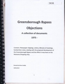 Greensborough Historical Society
Document - Document Collection, Greensborough Bypass: objections: a collection of documents 1975, 1975
Documents collected by Brian Smiddy from 1975. Includes newspaper clippings, handwritten notes, minutes of meetings dealing with the proposed development of the Greensborough Bypass and the effect it may have on the Watsonia Shopping strip. Contains objections to this development.Black plastic folder with black plastic binding containing approx 37 documents and handwritten notes.brian smiddy, greensborough bypass, watsonia road watsonia, watsonia shopping centre -
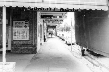 Eltham District Historical Society Inc
Photograph, Shopping centre, Main Road, Eltham, February 1968, Feb 1968
Main Road shops from midway between Luck and Pryor Streets, looking south along the east side. Includes Browne's Self Service, Delicatessen, Dairy Queen, Commonwealth Bank, Mac's Meats and Thompson's Chemist.In February 1968 an unknown person took a series of photos from the Eltham Hotel at Pitt Street heading north along Main Road through the shopping centre to just north of Elsa Court covering the length of the section of Main Road which was duplicated shortly thereafter. Shows the condition and environment of the streesscape of Main Road, Eltham immediately prior to the duplication between Pitt Street and Elsa Court through the shopping centre. Also shows a number of shops and businesses that operated at that time.Black and white photographduplication, eltham, main road, shopping centre, thompson's pharmacy, mac's meats, delicatessen, dairy queen, commonwealth bank, browne's self service -
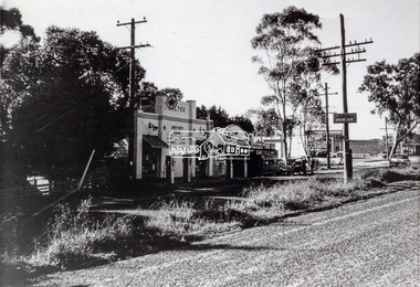 Eltham District Historical Society Inc
Photograph, Main Road, Lower Plenty at intersection of Old Eltham Road
View looking north across the main road towards the Lower Plenty shops showing the Lower Plenty Garage and store which was later developed into a Caltex service station, since demolished and replaced by a new Aldi supermarket.Black and white print Roll of 35mm colour negative film, 5 of 7 strips Kodak CP100 5094 and associated print Roll of 35mm black and white negative film, 3 strips Ilford FP4 and associated print Roll of 35mm colour negative film, 2 strips Kodak CP100 5094 and associated printaldi, caltex service station, lower plenty, lower plenty garage, lower plenty shops, main road, old eltham road, shops -
Glen Eira Historical Society
Letter - International Diabetes Institute, Kooyong Road, 260, Caulfield
This file contains 1 item: 1/A letter and flier addressed to the Caulfield Historical Society, from Evelyn Alperstein of the International Diabetes Institute 13/02/1997 requesting volunteers for their opportunity shops in Caulfield South and Elsternwick.caulfield historical society, international diabetes institute, kooyong road, elsternwick, caulfield south, alperstein evelyn, campbell f. mrs., charitable organisations, voluntary workers, caulfield -
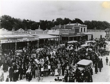 Clunes Museum
Photograph, c1920
Image shows looking east along Fraser Street, showing shops, including L. Cook Tearooms, M. Downes Boot Warehouse, Cash Draper, 4 Miles Central Garage, F C Henry, Barnetts.1 Black and white photograph of Fraser Street Clunes after a parade c1920, street is filled with people celebrating .2 Larger reproduction of the above photograph in black and white.1 £4.00parade, fraser street, 1920, l cook tearooms, m downes boot warehouse, cash drapery, h miles central garage, f c henry, barnetts -
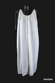 Whitehorse Historical Society Inc.
Clothing - Negligee Set, 1966
Worn as part of her trousseau by Rosalie Whalen on her honeymoon after her wedding on 1st June 1966 at St Andrews Presbyterian Church, Gardiner, Vic.|Bought at a shop at the top of Collins Street 'The Paris End'.Rosalie is the great great grand-daughter of Johann August Schwerkolt, pioneer of Mitcham.1. 1966 white sleeveless batiste nightgown with salmon pink silk Rouleau ties on shoulders. The armholes and neckline are edged with the salmon silk. 2. The elbow-length sleeved coat has a gathered neckline edged with salmon pink Rouleau and tied at the opening (which does not have any fastenings). The sleeves are raglan with elastic casing and decorated with a salmon pink bow. See also wedding dress NA4579 and hat NA4597.costume, female nightwear -
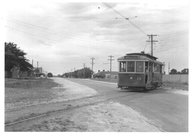
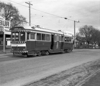 Ballarat Tramway Museum
Photograph - Digital Image, Peter Knife, SEC 42 at the Mt Pleasant terminus, 14/8/1965
Digital image of SEC 42 at the Mt Pleasant terminus. The tram has the destination of Gardens via Drummond St Nth. In the background is the Milk bar/shop that was located at the terminus. Photo by Peter Knife 14 Aug 1965.Yields information about Ballarat's trams in August 1965.Digital image of a black and white negativetramways, tramcars, ballarat, mt pleasant, tram 42 -
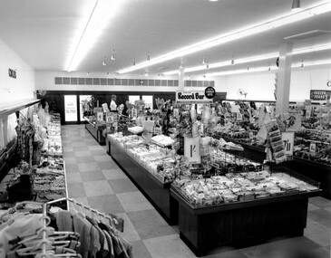 City of Kingston
Photograph - Black and white, c. 1956
This photograph depicts the interior of the Coles Variety Store within Bentleigh's Centre Road shopping precinct in 1956. Signage represents the pre decimal currency era. The Record Bar advertises the availability of standard and microgroove vinyl records.In this era, the Centre Road Bentleigh shopping strip provided consumers with access to many of the major retail outlets and provided for a wide range of shopping needs. By the 1960s, Chadstone Shopping Centres (opened 1960) and Southland (opened 1968) had been established which created changes to the way in which people shopped.Black and white photograph of interior of Coles Store in Centre Road, Bentleigh displaying prominent signage predating decimal currency. Other signage includes the Coles Record Bar indicating the sale of standard and microgroove vinyl records.Handwritten in blue ink: Coles Bentleigh Sep 1956 B Black printed text on white round adhesive sticker: 202 Handwritten in red ink: 80%shopping strip, strip shopping, bentleigh, city of moorabbin, coles stores -
 City of Kingston
Photograph - Black and white, 20 December 1945
This aerial photograph depicts the changing landscape of Cheltenham and Highett since WWII. Photographed in 1945, there is a mix of urban dwellings and industrial development and precedes the major transformation of Cheltenham with the development of the Southland shopping centre in the 1960s and expansion in the 1990s.A large part of Cheltenham was originally established as a rural market gardening community. The railway line and station brought urban development to the area and in the north, the Highett area was dominated by the Highett Gas Works. Cheltenham became a major destination for shopping in the 1960s with the opening of Southland.Aerial photograph taken in 1945 of Cheltenham and Highett within the City of Kingston. The image includes the Highett Reserve, (top right), the Methodist Children Homes (now Southland), Nepean Highway and Jamieson Street. Highett Gas Works is visible in the top left and the land now named William Fry Reserve at the intersection of Bay Road and Nepean Highway. A visible large parcel of land on the corner of Bay Road and Nepean Highway was developed in the 1990s as the west side addition to Southland. The densely vegetated area in the upper right sector of the image is now dense with housing. Tulip Grove, Heather Grove and Gilford Street are visible bottom left. This image is possibly from the collection of aerial photographs commissioned by the Department of Crown Lands and Survey and taken by Adastra Airways.Black ink: 57252 White lettering: VIC-10 57252 20.12.45 [lens information indecipherable] PROJ. No.5 MELB. METROP AREA Black pencil: 80highett, cheltenham, highett gas works, urbanisation -
 City of Kingston
Photograph - Black and white, 20 December 1945
This aerial photograph depicts the changing landscape of Cheltenham and Highett since WWII. Photographed in 1945, there is a mix of urban dwellings and industrial development and precedes the major transformation of Cheltenham with the development of the Southland shopping centre in the 1960s and expansion in the 1990s.A large part of Cheltenham was originally established as a rural market gardening community. The railway line and station brought urban development to the area and in the north, the Highett area was dominated by the Highett Gas Works. Cheltenham became a major destination for shopping in the 1960s with the opening of Southland.Aerial photograph taken in 1945 of Cheltenham and Highett within the City of Kingston. The image includes the Highett Reserve, (top right), the Methodist Children Homes (now Southland), Nepean Highway and Jamieson Street. Highett Gas Works is visible in the top left and the land now named William Fry Reserve at the intersection of Bay Road and Nepean Highway. A visible large parcel of land on the corner of Bay Road and Nepean Highway was developed in the 1990s as the west side addition to Southland. The densely vegetated area in the upper right sector of the image is now dense with housing. Tulip Grove, Heather Grove and Gilford Street are visible bottom left. This image is possibly from the collection of aerial photographs commissioned by the Department of Crown Lands and Survey and taken by Adastra Airways.Black type: Reverse lettering VIC-10 57252 20.12.45 [lens information indecipherable] PROJ. No.5 MELB. METROP AREA White lettering: Reverse writing 57252cheltenham, highett, highett gas works, urbanisation -
 Ballarat Tramway Museum
Photograph - Ballarat tram 13 crossing Albert St, Ken Winney, 12/1949
The photograph shows SEC Ballarat tram No. 13 crossing Albert St on its way to Sebastopol. Has some of the Sebastopol shops in the background on the left side of the image. Photo by I K Winney of Sydney, 12/1949.Yields information about tram 13 and the location where the tram crossed Albert St. Sebastopol.Black and white photograph with photographers details on rear."Car No. 13 en route to Sebastopol crossing from left to right side of road, Ballarat 12/1949, I K Winney"tramcars, sebastopol, albert st., tram 13 -
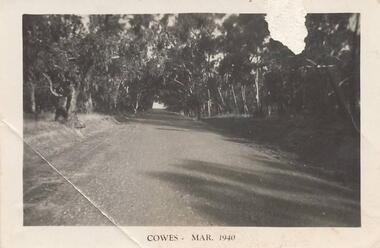 Phillip Island and District Historical Society Inc.
Photographs, 1940's
Seven photographs from a collection of 33 donated by Leonie Brennan. Photographs belonged to Edward (Ted) Sands, hairdresser.Photograph 215-10. Phillip Island Tourist Road (Cowes to Newhaven) in 1940, showing mature eucalypt trees on both sides of the road. Photograph 215-11. Car and tent possibly on a foreshore area on Phillip Island. The car was owned by "Roy". Photograph 215-12. Phillip Island Hotel in Walpole Street, Cowes. Photograph 215-13. Newhaven Boys Home showing farm buildings. Photograph 215-14. Bayview Guest House, The Esplanade, Cowes, with distinctive front fence. Photograph 215-15. The Chapel at Newhaven Boys Home, Phillip Island. Photograph 215-16. The Alvina ferry with passengers on board. Photograph 215-17. Very dark photograph of shops in Cowes. One with sign showing ice-creams and a Grocer Shop next door.Four photographs with "Cowes" month and 1940.main tourist road, phillip island, camp site phillip island, phillip island hotel cowes, hotels, guesthouses cowes phillip island, bayview guesthouse cowes, newhaven boys home phillip island, newhaven boys home chapel, the alvina, ferries, shops at cowes phillip island, mr edward (ted) sands, leonie brennan -
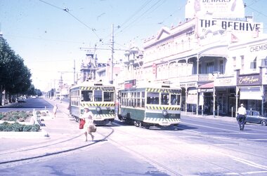 Ballarat Tramway Museum
Slide - 35mm slide/s - set of 4, Peter Moses, Jan. 1969
Set of four colour slides taken at Charing Cross Bendigo, Jan. 1969. .1 - Trams 30 and 28 travelling to North Bendigo and Golden Square respectively. Has the Beehive building in the background, along with W.M.I. Jones Chemist, Evelyn Amor shop, Dewars Whiskey rooftop advertisement. 28 has a SEC Briquettes roof advertisement. .2 - As above but with the front or bogie tram in the photo. Also has A. G. Treloar Optician's shop. Kodak cardboard mount slide, taken by Peter Moses, Jan. 1969. .3 - Close up photo of Birney No. 30, with 28 in the background. .4 - No. 28 leaving for Golden Square with the Plaza building, the Cenotaph, and the City Family Hotel in the background. Kodak cardboard mount slide, taken by Peter Moses, Jan. 1969.On the rear of all the slides "P. Moses" in black ink .1 - "Bendigo Charing Cross" and in red ink "19" .2 - "Bendigo three trams / Charing Cross" and in red ink "21" .3 - "Bendigo" and in red ink "23" .4 - "Bendigo Charing Cross" and in red ink "14". tramways, trams, bendigo, tram 28, tram 30 -
 Ballarat Heritage Services
Digital photographs, fiveways (Denmark, Studley Park, Princess, High, High South) from Kew Junction (Cotham and High), c2017
Digital images of Kew Junction.kew, kew junction, five ways, streetscape, cotham road, high street, road, shop, shopping centre, strip shopping centre, commercial -
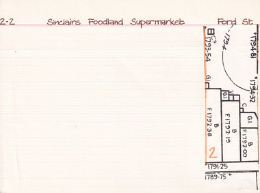 The Beechworth Burke Museum Research Collection
Card (Series) - Index Card, George Tibbits, Ford Street, Beechworth, 1976
George Tibbits, University of Melbourne. Faculty of Architecture, Building and Town & Regional PlanningIndex system that support the research for Beechworth : historical reconstruction / [by] George Tibbits ... [et al]Arranged by street names of BeechworthEach index card includes: street name and number of property, image of property, allotment and section number, property owners and dates of ownership, description of the property according to rate records, property floor plan with dimensions.beechworth, george tibbitsbeechworth, george tibbits -
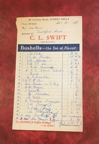 Surrey Hills Historical Society Collection
Document - Account, C. L. Swift order docket re Mrs Matthews. 21/8/1957, 21 August 1957
Clive Leslie Swift (RAAF 430415) was born in Elsternwick in 1924 and served in the RAAF in Borneo during WW2. He was mentioned in dispatches. He married Enid (Ina) Mary Smith in 1947. Together they ran the grocery store at 10 Croydon Road from 1949 until some time after 1954. In the 1980s they were living in Highbury Road, East Burwood and Clive was working for Unigate (later Bonlac) in a managerial position. (REF: Oral testimony, Libby Wilson, Canterbury History Group). The shop continued after the Swifts left but was later destroyed by fire. Clive Swift died in March 2014. This and other dockets were tucked into Ruth Matthews' recipe folder. Ruth and Harold Geoffrey (Geoff) Matthews lived at 42 Guildford Road, Surrey Hills. The donor recalled that her paternal grandmother (Ethel May Matthews) also occasionally shopped at the Swifts' shop as it was closer to her home (31 Guildford Road) than either than Griffith’s on Union Road or Thomas’ on Maling Road . Dockets such as these are reflective of shopping in the pre-supermarket era when women generally walked to the local shop or had proprietors or a staff member come to the house to take weekly orders. A pre-printed grocery docket for C. L. Swift (Late R.A.A.F.) on cream (discoloured) paper printed in black, red and blue filled in with 20 hand-written items, their prices and the total of the grocery order. Signed with initials as having been paid. Order was for Mrs Matthews of Guildford Road.On the rear in blue ink an addition in pounds, shillings and pence.clive leslie swift, miss enid (ina) mary smith, mrs enid (ina) mary swift, croydon road, guildford road, grocery store, docket, accounts, bushells tea, mrs ruth matthews, harold geoffrey matthews, 'geoff' matthews -
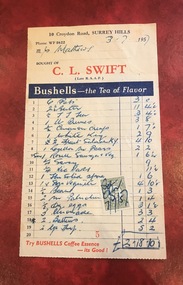 Surrey Hills Historical Society Collection
Document - Account, C. L. Swift order docket re Mrs Matthews. 21/8/1957, 3 July 1957
Clive Leslie Swift (RAAF 430415) was born in Elsternwick in 1924 and served in the RAAF in Borneo during WW2. He was mentioned in dispatches. He married Enid (Ina) Mary Smith in 1947. Together they ran the grocery store at 10 Croydon Road from 1949 until some time after 1954. In the 1980s they were living in Highbury Road, East Burwood and Clive was working for Unigate (later Bonlac) in a managerial position. (REF: Oral testimony, Libby Wilson, Canterbury History Group). The shop continued after the Swifts left but was later destroyed by fire. Clive Swift died in March 2014. This and other dockets were tucked into Ruth Matthews' recipe folder. Ruth and Harold Geoffrey (Geoff) Matthews lived at 42 Guildford Road, Surrey Hills. The donor recalled that her paternal grandmother (Ethel May Matthews) also occasionally shopped at the Swifts' shop as it was closer to her home (31 Guildford Road) than either than Griffith’s on Union Road or Thomas’ on Maling Road . Dockets such as these are reflective of shopping in the pre-supermarket era when women generally walked to the local shop or had proprietors or a staff member come to the house to take weekly orders. A pre-printed grocery docket for C. L. Swift (Late R.A.A.F.) on cream (slightly discoloured) paper printed in black, red and blue filled in with 19 hand-written items, their prices and the total of the grocery order. A green and cream duty stamp to the value of 3d is attached and over-signed with initials as having been paid. Order was for Mrs Matthews of Guildford Road.clive leslie swift, miss enid (ina) mary smith, mrs enid (ina) mary swift, croydon road, guildford road, grocery store, docket, accounts, bushells tea, mrs ruth matthews, harold geoffrey matthews, 'geoff' matthews -
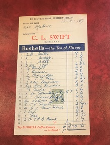 Surrey Hills Historical Society Collection
Document - Account, C. L. Swift order docket re Mrs Matthews. 21/8/1957, 13 August 1957
Clive Leslie Swift (RAAF 430415) was born in Elsternwick in 1924 and served in the RAAF in Borneo during WW2. He was mentioned in dispatches. He married Enid (Ina) Mary Smith in 1947. Together they ran the grocery store at 10 Croydon Road from 1949 until some time after 1954. In the 1980s they were living in Highbury Road, East Burwood and Clive was working for Unigate (later Bonlac) in a managerial position. (REF: Oral testimony, Libby Wilson, Canterbury History Group). The shop continued after the Swifts left but was later destroyed by fire. Clive Swift died in March 2014. This and other dockets were tucked into Ruth Matthews' recipe folder. Ruth and Harold Geoffrey (Geoff) Matthews lived at 42 Guildford Road, Surrey Hills. The donor recalled that her paternal grandmother (Ethel May Matthews) also occasionally shopped at the Swifts' shop as it was closer to her home (31 Guildford Road) than either than Griffith’s on Union Road or Thomas’ on Maling Road . Dockets such as these are reflective of shopping in the pre-supermarket era when women generally walked to the local shop or had proprietors or a staff member come to the house to take weekly orders. A pre-printed grocery docket for C. L. Swift (Late R.A.A.F.) on cream (slightly discoloured) paper printed in black, red and blue filled in with 19 hand-written items, their prices and the total of the grocery order. A green and cream duty stamp to the value of 3d is attached and over-signed with initials as having been paid. Order was for Mrs Matthews of Guildford Road.clive leslie swift, miss enid (ina) mary smith, mrs enid (ina) mary swift, croydon road, guildford road, grocery store, docket, accounts, bushells tea, mrs ruth matthews, harold geoffrey matthews, 'geoff' matthews -
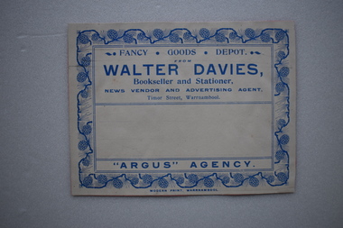 Warrnambool and District Historical Society Inc.
Label, Walter Davies
Walter Davies came to the Warrnambool area in the mid 1850's and established a newsagency, book shop and stationery business. After his death the business continued into the 20th century with family members and others using the same business name.This is a significant label as it was used by a prominent business in Timor Street, Warrnambool.Buff coloured label with blue text and decorative border .The label is adhered to a piece of pink card.FANCY . GOODS. DEPOT. WALTER DAVIES. Bookseller and Stationer. NEWS VENDOR AND ADVERTISING AGENT. Timor Street, Warrnambool "ARGUS" AGENCY MODERN PRINT, WARRNAMBOOLwalter davies, newsagency, book shop, stationers, warrnambool