Showing 10985 items matching " plan."
-
 Canterbury History Group
Ephemera - "Mulberry Hill" 40 Balwyn Avenue Canterbury
Real Estate Advertisement for the sale of "Mulberry Hill" Includes sketch of the exterior of the house, photographs of the exterior and interior plus floor planscanterbury, balwyn road, mulberry hill, sinclair & co -
Canterbury History Group
Ephemera - The charm of a cottage garden, [2000]
Real estate advertisement for the sale by auction of 12 Dryden Street Canterbury in [2000]. Includes a sketch of the exterior of the house and a floor plan.canterbury, dryden street, edwardian style -
 Bendigo Historical Society Inc.
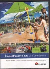
Booklet - Gemma Starr collection - City of Greater Bendigo Council Plan booklet 2013 - 2017; 37-page booklet printed in-house
Gemma Starr collection - City of Greater Bendigo Council Plan booklet 2013 - 2017; 37-page booklet printed in-house.local hiostory, social -
 Surrey Hills Historical Society Collection
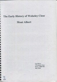
Book, The early history of Wolseley Close, Mont Albert, 2010
Includes copy of will of William Clark. Resident of the property at 9 Wolseley Close in 1910. Includes copy of the Alan Holts home occupier / tenant records - names from 1920 - 1980. Includes photo of Wolseley Close house, taken 1888/1889 plus colour photo of Wolseley Close house taken by Lin Merry, 2010. Land Title information, surveys, subdivision Includes list of occupants of the house, p.17Includes some plans of houses built in Wolseley Close, Mont Albert, Victoria. Outlines details of property at 9 Wolseley Close19p : col illcragg family, windsor crescent, surrey hills, (mr) william ainger, (mr) isaiah ainger, whitehorse road, noorn hill, house names, koonda, d j maloney, (mrs) louisa clara maggs, taramera, union road, st.abbs, york street, (mr) william henry cleverdon, wolseley street, windsor park estate, tarawera, merry family, clinton family, adams family, tel-el-kebir, farrell family, (mr) william clark, trafalgar street, (mr) (sir) matthew davies, (mr) c h james, (mr) james munro, (mrs) elizabeth clark, langdale, (mr) stanley dewar, (mr) john jose, (mrs) emily hampton, potton, (mr) alexander potton, (mr) john atkinson morris, freehold investment & banking co., mont albert, windsor park surrey hills, dalton family, (mr) henry wood, wolseley close -
 Falls Creek Historical Society
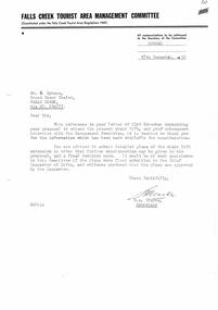
Letter - Proposal To Extend Present Chair Lift
Bob Hymans Collection Bob (Herman) Hymans (a former member of the Royal Netherlands Navy was born in Bloemendaal, Holland on 30th September 1922. During World War II he fought against the Japanese in the Dutch East Indies (now Indonesia) and was imprisoned in Changi and on the Burma Railway. After gaining qualifications as a Ski Instructor, Bob arrived in Falls Creek in May 1950. Working as an Instructor and Supervisor at Bogong Lodge, Bob decided his future was in accommodation. He was successful in negotiating an indenture for land from the State Electricity Commission (SEC). It took Bob two years to build his Grande Coeur Chalet but, tragically, it was burned down in August 1961. Bob also built the first Chairlift in Australia. This was a single chairlift and the structure was built from wooden electricity poles. He was constantly full of new ideas and proposals for the village. Bob Hymans died on 7th July 2007. This Collection of documents and letters tells the story of Bob’s endeavours to develop Falls Creek into the ski village it is today.This document is significant because it documents the Bob Hymans' proposals for Falls Creek..A letter from the Falls Creek Tourist Area Management Committee requesting detailed plans for the proposed extension of Bob Hymans' chairlift.chairlift falls creek, bob hymans, falls creek tourist area -
Canterbury History Group
Map - Victorian Railways, Canterbury, Drainage Plan, cc1910
Drainage plan around Canterbury Station, Canterbury Road and Maling Road .5 pages of photocopies from the Public Record Officecanterbury, canterbury road, maling road, canterbury station, drainage, stormwater channels -
University of Melbourne, Burnley Campus Archives
Plan, Aberfeldie, Trawalla, 1905
Photocopies of Melbourne Metropolitan Board of Works plan showing 2 adjoining house and garden sites in Toorak, Victoria, 'Aberfeldie' and 'Trawalla'. Handwritten, "Map 937a, Map 937b 'Trawalla', Map 937c, Map 937d."toorak, houses, melbourne metropolitan board of works, "aberfeldie", "trawalla" -
 Bendigo Historical Society Inc.
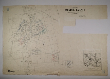
Map - MEMSIE ESTATE, 26/08/1905
Map:Plan of Memsie estate, aquired under Closer Settlement Act 1904. Parish plan. Map dated 26/08/1905.map, estate, memsie estate, closer settlement act 1904. -
University of Melbourne, Burnley Campus Archives
Plan, City of Richmond Development of Old Burnley School Site, c. 1986
Plan for Park - area bounded by Madden Grove, Parkville, Stawell and Gibdon Streets Richmond. Scale 1:200. CP-72047186.richmond, burnley, burnley school, parks, golden square bicentennial park -
Lakes Entrance Historical Society
Book, Ellem, Elizabeth Wood, Victoria Felix A celebration of the 50th Parliament of Victoria 1856-1985, 1985
A History of the system of government in Victoria, from the first Parliament in 1856 until the 50th. Parliament in 1985. Illustrated with sketches, plans and photographs.history, government, buildings, politics -
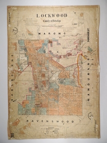 Bendigo Historical Society Inc.
Map - LOCKWOOD, 13/03/1876
Map: Lockwood, County of Bendigo. Parish plan. Compiled Jan. 1876. W. P. Lake Draftsman. paper on canvas backing.map, bendigo, parish plan, lockwood, w. p. blake -
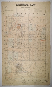 Bendigo Historical Society Inc.
Map - JANIEMBER EAST, 26/07/1879
Map: Janiember East, County of Bendigo. Parish plan Examined by T Pures 16.10.75 S M Reed August 1875map, bendigo, parish plan, janiember east, serpentine -
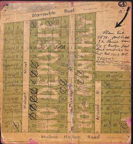 Ringwood and District Historical Society
Map, Residential Subdivision Allotment Layout on Mullum Mullum Road, Hobart Street, Paxton Street, Arnold Street and Warrandyte Road, Ringwood, Vic. (Undated, circa 1920)
Map on cardboard backing clipped from Subdivision Plan 7578 - Part of Crown Allotment 32, Parish of Warrandyte, County of Evelyn.H.C. Crouch, Licensed Surveyor, 443 Lt Collins Street, Melbourne. Includes handwritten real estate sales notations and Certificate of Title reference - Vol 3922 Fol 784242. -
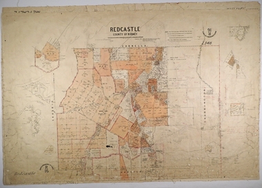 Bendigo Historical Society Inc.
Map - REDCASTLE, 15/10/1878
Map: Redcastle, County of Rodney. Parish plan. Examined E. D. Downward 28.9.78 T, S Hall Aug 78map, rodney, parish plan, redcastle, t. s. hall, e. d. downward -
University of Melbourne, Burnley Campus Archives
Plan - Student Work, D. Allen, Smith Residence - Back Yard: Concept, 07.06.2014
assignment, student work, landscape design, d.allen -
Port Melbourne Historical & Preservation Society
Plan - Proposed Beacon Cove Development plan by Sandridge City Development Company Pty Ltd, 17 July 1989
A photocopy of a detailed of areas 1, 7 & 8 of the plan for Beacon Cove from the Sandridge City Development Company Pty Ltd.sandridge city development company pty ltd, local government - city of port melbourne, beacon cove -
Clunes Museum
Plan - Map, Clunes Caravan Park Amenities Block
Four copies of draftsman plans for the amenities block at the Clunes Caravan Park, one copy has been amended with red penSigned by R. A. Boyd 12/71 Engineercaravan park, amenities upgrade -
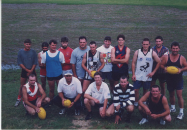 Lakes Entrance Historical Society
Photograph - Football, Lakes Post Newspaper, 1/02/1999 12:00:00 AM
Colour photograph of sixteen members of Swan Reach Football Club meeting for a kick and to plan the year ahead Swan Reach Victoriaclubs, football -
![Monnington [Estate], 1935](/media/collectors/550653872162f11fb04854aa/items/5907eb86d0ce0c14e82385c8/item-media/5907ecafd0ce0c14e823e87f/item-fit-380x285.jpg) Kew Historical Society Inc
Kew Historical Society IncPlan - Subdivision Plan, Monnington [Estate], 1935, 1935
Pru Sanderson, in her groundbreaking ‘City of Kew Urban Conservation Study : Volume 2 - Development History’ (1988), summarised the periods of urban development and subdivisions of land in Kew. The periods that she identified included 1845-1880, 1880-1893, 1893-1921, 1921-1933, 1933-1943, and Post-War Development. These periods were selected as they represented periods of rapid growth or decline in urban development. An obvious starting point for Sanderson’s groupings involved population growth and the associated economic cycles. These cycles also highlighted urban expansion onto land that was predominantly rural, although in other cases it represented the decline and breakup of large estates. A number of the plans in the Kew Historical Society’s collection can also be found in other collections, such as those of the State Library of Victoria and the Boroondara Library Service. A number are however unique to the collection.Subdivision plans are historically important documents used as evidence of the growth of suburbs in Australia. They frequently provide information about when the land was sold on which a built structure was subsequently constructed as well as evidence relating to surveyors and real estate and financial agents. The numerous subdivision plans in the Kew Historical Society's collection represent working documents, ranging from the initial sketches made in planning a subdivision to printed plans on which auctioneers or agents listed the prices for which individual lots were sold. In a number of cases, the reverse of a subdivision plan in the collection includes a photograph of a house that was also for sale by the agent. These photographs provide significant heritage information relating house design and decoration, fencing and household gardens.The first subdivision of Monnington took place in 1935. At that time, Monnington and 10 new allotments were offered for sale bordering Adeney and Marshall Avenues. In this subdivision plan, Monnington is one of 13 lots for sale. The subdivision created the irregular land holding of Monnington today. The excision of southwest corner of Monninton was caused by the need to have regular allotments facing the curve in Marshall Avenue.monnington - adeney avenue -- kew (vic.), subdivision plans -- kew (vic.) -
 Kew Historical Society Inc
Plan - Subdivision Plan, Eastlawn Estate, 1914
Subdivision plans are historically important documents used as evidence of the growth of suburbs in Australia. They frequently provide information about when the land was sold on which a built structure was subsequently constructed as well as evidence relating to surveyors and real estate and financial agents. The numerous subdivision plans in the Kew Historical Society's collection represent working documents, ranging from the initial sketches made in planning a subdivision to printed plans on which auctioneers or agents listed the prices for which individual lots were sold. In a number of cases, the reverse of a subdivision plan in the collection includes a photograph of a house that was also for sale by the agent. These photographs provide significant heritage information relating house design and decoration, fencing and household gardens.The ‘Eastlawn Estate’ was surveyed and ready for auction in March 1914, three months before the outbreak of World War I. Sixty-six allotments, created on the ‘order of Mr & Miss Preston’ surrounded the mansion of Woodlands in Harp Road. Woodlands formed part of the Estate, being advertised as lot 1. The allotments faced High, Station and Wright Streets, Harp and Normanby Roads, and Woodlands Avenue. Pru Sanderson in the Kew Conservation Study (Vol.2, 1988) wrote that the Eastlawn Estate ‘covered the western half of the failed Harp of Erin Estate’. Contemporary advertisements promoted the Eastlawn Estate as: ‘There will be no more convenient district nor pleasant Suburb than East Kew for the busy business man. When the Electric Tram is laid, he will be able to journey quickly and pleasantly direct from Collins Street to his home in the Eastlawn Estate in about 20 minutes’. The actual plans of subdivision were included in advertisements in The Argus and in the local newspapers.subdivision plans - east kew, eastlawn estate -
 Kew Historical Society Inc
Photograph - 29 Uvadale Grove, Kew, 1920
The numerous subdivision plans in the Kew Historical Society's collection represent working documents, ranging from the initial sketches made in planning a subdivision to printed plans on which auctioneers or agents listed the prices for which individual lots were sold. In a number of cases, the reverse of a subdivision plan in the collection includes a photograph of a house that was also for sale by the agent. Subdivision plans are historically important documents used as evidence of the growth of suburbs in Australia. They frequently provide information about when the land was sold on which a built structure was subsequently constructed as well as evidence relating to surveyors and real estate and financial agents. These photographs provide significant heritage information relating house design and decoration, fencing and household gardens.When 29 Uvadale Grove, Kew was offered for sale it was described as: ‘Kew. Fine locality, 3 minutes Cotham Road. Splendidly built 6 roomed Brick Villa. Rooms 17 x 14, 16 x 13, &c. Beautifully fitted throughout. Land 70 x 134 to ROW.’ The price was advertised as being £1,400. The house exhibits key features of Federation architecture such as the gabled roof with a facing of half-timber and stucco. The veranda has a curved corrugated iron roof supported by timber pillars and fretwork. The slate roof with terra cotta ridging and finials marks a transition to the more common use of Marseilles tiles in Federation architecture.subdivisions - kew (vic.), 29 uvadale grove - kew (vic.) -
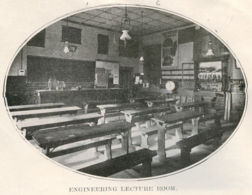 Federation University Historical Collection
Book, Ballarat School of Mines, Ballarat School of Mines Calendar, 1911, 1911
In 1911 R. Maddern was President of the Ballarat School of Mines. Contents of this booklet are: Asssociateship, Calendar, Certificate Courses, Departmental Regulations, Discipline, Discipline Board, Examination Results, Fees, Full Certificates Issued, General Regulations, Introduction, Junior Technical School, Officer Bearers, Professors and Lecturers, Subjects of Instruction - Department of Chemistry and Metallurgy, Geological Department, Engineering Department, Electrical Engineering Department, Department of Mathematics and Physics, Practical, Plane and Solid Geometry, Photography, Subscriptions and Donations 1910. Plan of Buildings and Grounds Engineers with qualifications from the Ballarat School of Mines were sought by mines throughout the world. Blue soft covered book of 64 pages titled the Ballarat School of Mines Calendar. The book includes images of the Engineering Room, the Maddern Roasting Furnace, Museum, Junior Chemical Laboratory, Plan of Buildings and Ground, Chemical Laboratory, Concentration Floor, Linkenbach Table, Engineering Laboratory, Experimental Steam Engine, Chemical Lecture Room, Physics Instruction Room, Newtonian Telescopy, Ballarat Observatory, Instructor's Laoratory, Wilfrey Table, Chlorination plant, Cyanide House and R. Maddern. ballarat school of mines, scientific equipment, engineering, classroom, desks, gas lighting, calendar, r. maddern, j. m. bickett, w. h. middleton, j. d. woolcott, w. nixon, daniel. walker, fred j. martell, professor a. mica smith, hubert r. murphy, charles a. deane, arthur garrard, professor t. s. hart, professor a. d. gilchrist, a. e. c. kerr, j. brittain, e. j. a. mcconnon, john m. sutherland, bertram whitington, h. j. hall, e. gutheil, charles campbell, t. williams, d. e. mullins, sir redmond barry, judge rogers, r. m. sergeant, thomas bath, andrew anderson, general regulations, discipline, discipline board, associateship and final certificates, mining engineering, metallurgy, geology, electrical engineering, certificate courses, junior technical school, fees, subjects of instruction, chemistry, geological department, engineering department, electrical engineering department, department of mathematics and physics, practical, plane and solid geometry, photography, full certificates issued, supplementary examination results - may 1910, supplementary examination results - april 1908, subscriptions and donations 1910 -
 Eltham District Historical Society Inc
Book, Yarra Valley Metropolitan Park - Base Data and Analysis - Draft Report - Vol. III -Appendix 1997, 1977
Data collection and analysis, concept and policy planning, development plan for proposed Yarra Valley Metropolitan Park30 cm -
Federation University Historical Collection
Book, Journal pertaining to BORES Berry Mines
This book is associated with former Ballarat School of Mines Student Richard Squire (1875-1876). Gift of the Squire FamilyGreen water marked linen covered journal with maroon spine with red feint lined blue pages. Label on front cover is cream with black printing JOURNAL with handwritten BORES. Hand written in black ink. Plans of shafts throughout 182 pages.Map/plan loose at page 48. Index on pages 176 - 181Bores written on front cover berry consols, bores, gold, gold mining, mining, shafts, g. maryhans, charlesons, davies, coopers, west berry consols gold mining company -
Bendigo Historical Society Inc.
Map - CAMPBELL COLLECTION: BENDIGO AND DISTRICT MAPS, 23-4-29
Map. Whirrakee, Parish of Whirrakee, Total area 4419 acres, scale 20 chains to 1 inch. Unused water race in centre of map. Eucalypt Oil Distillery, bottom of map. Prepared in W.P.B. from Assessor's Plan and Parish Plan. G.W.Latimer 23-4-29. (number 385 in map cupboard 1)G.W.Latimermap, bendigo, agricultural lands -
 Warrnambool and District Historical Society Inc.
Book, Road register loose binder, 1953
This is an Alphabetical Register of the streets in Warrnambool as listed by Warrnambool City Council officers. It appears to have been a working register used in the 1950s, 60s and 70s and information has been added to the entries as it became available and as Council works were carried out in these streets. It contains information on the locality, wards, allotment numbers, lodged plan numbers, footpaths and printed information from the Victorian Local Government Departments. It sometimes gives the origin of the name of the street and some other miscellaneous information is included. It is presumed that the information contained therein has now been stored electronically. This is a most important ledger as it contains much valuable historical information on Warrnambool streets. It will be of great use to researchers. This is a loose leaf binder with a black leather cover and a black metal and cord binding mechanism. The pages are unnumbered but there is provision for insertion or removal of pages and there are leather alphabetical tabs protruding from the pages. The pages have blue ruled lines with blue lined margins and headings. The streets in Warrnambool are listed alphabetically and the information in the register contains both typed and handwritten material. There are also printed notices from the Victorian Local Government department, extracts from newspapers, copies of letters and plans of street subdivisions. There is one loose page.warrnambool city council, warrnmbool streets register -
 Kew Historical Society Inc
Plan - Subdivision Plan, Kewdene Estate, 1937-1939
Pru Sanderson, in her groundbreaking ‘City of Kew Urban Conservation Study : Volume 2 - Development History’ (1988), summarised the periods of urban development and subdivisions of land in Kew. The periods that she identified included 1845-1880, 1880-1893, 1893-1921, 1921-1933, 1933-1943, and Post-War Development. These periods were selected as they represented periods of rapid growth or decline in urban development. An obvious starting point for Sanderson’s groupings involved population growth and the associated economic cycles. These cycles also highlighted urban expansion onto land that was predominantly rural, although in other cases it represented the decline and breakup of large estates. A number of the plans in the Kew Historical Society’s collection can also be found in other collections, such as those of the State Library of Victoria and the Boroondara Library Service. A number are however unique to the collection.The Kew Historical Society collection includes almost 100 subdivision plans pertaining to suburbs of the City of Melbourne. Most of these are of Kew, Kew East or Studley Park, although a smaller number are plans of Camberwell, Deepdene, Balwyn and Hawthorn. It is believed that the majority of the plans were gifted to the Society by persons connected with the real estate firm - J. R. Mathers & McMillan, 136 Cotham Road, Kew. The Plans in the collection are rarely in pristine form, being working plans on which the agent would write notes and record lots sold and the prices of these. The subdivision plans are historically significant examples of the growth of urban Melbourne from the beginning of the 20th Century up until the 1980s. A number of the plans are double-sided and often include a photograph on the reverse. The advertisement for the ‘Kewdene Estate’ subdivision is pasted over a photograph of a property for sale. This is typical of the reuse of promotional materials in the period during, and subsequent to World War I. The subdivision included 14 lots bordered by Belmore Road, Birtles Street and Giles Street. On the other side of the subdivision [Glass] Creek is noted. The subdivision plan also shows part of the Outer Circle Railway and Deepdene Railway Station.subdivision plans - east kew, kewdene estate, belmore road -- kew east (vic.), giles street -- kew east (vic.) -
 Ringwood and District Historical Society
Map, Proposed Subdivision - Hilltop Estate, Heathmont, Victoria - circa 1925
Plan of Part of Crown Allotments 16 & 18, Parish of Ringwood, County of Mornington. Subdivision includes Site for Heathmont Station, Heathmont Road, George Street, Lilian Street, Edith Street, Edna Street, Great Ryrie Street. Inset locality plan also shows nearby Electric Railway Estate and Heathmont Station Estate. L.H. Webber, Licensed Surveyor, 440 Little Collins Street, Melbourne. -
Bendigo Historical Society Inc.
Map - CAMPBELL COLLECTION: BENDIGO AND DISTRICT MAPS
Map. Ascot, Parishes of Huntly, Sandhurst and Wellsford. Scale 20 chains to 1 inch. Total area 2818 acres. To Bendigo 4 1/2 miles, to Epsom 3/4 mile, Huntly 3/4 mile. Prepared in W.P.B. from Assessment Plans and Parish Plans. (number 380 in map cupboard 1)map, bendigo, agricultural lands -
Port Melbourne Historical & Preservation Society
Plan - Proposed docks and straight cut canal, Port Melbourne, Proposed Harbour Accommodation, 23 Sep 1902
Large plan of proposed docks and straight cut canal, reserve, proposed Harbour Accommodation - Port Melbourne. (Brown with age/or dirt) Shows enormous landfill into Hobson's Bay and around Town and Railway Piers; branch railway lines. Includes dredging plans and two narrow docks at Melbourne - also garden reserve and suburb of Fishermen's Bend.melbourne harbor trust - port of melbourne authority, town planning - proposals shelved, fishermans bend