Showing 10434 items
matching sites
-
 National Wool Museum
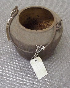
Pot, smelting
Found by Roger Cummings and J Lewis in laneway running south from Western Beach Road between Dalgety North building and Dennys Lachelles building (old Corio Tannery site). -
 Halls Gap & Grampians Historical Society
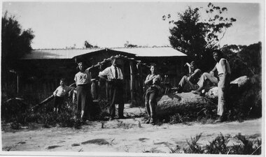
Photograph - B/W, C 1930s
The people in the photo are: Mr & Mrs Gus Knight and Ray Knight (on the right). The names of the other three people are not known. The site of the house is where a later monument would stand (see inscription).Photo shows six people; three seated on a large log, two standing and one leaning on a tree stump; in front of a house."Mr & Mrs Gus Knight, Ray on right. -Where Monument will go. Ray just cut down tree - so it would not fall on house." written in biro on rear of photo. "Wannon" written in pencil on rear of photo.people, knight, buildings, tea rooms -
 Halls Gap & Grampians Historical Society
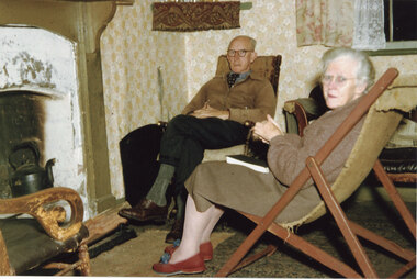
Photograph - Coloured, C 1955-56
The couple are May & David Mitchell in the front room of their holiday shack called "The Holiday Hut" - built by E.C. Mitchell of Stawell at the site of the Borough Huts. See Rec 586 for more information.The photo shows a man and a woman seated opposite a fireplace. A black kettle is sitting in fire place and a piece of wood has been placed on a fire surround. The man is sitting on what appears to be a rocking chair and the woman is sitting on a deck chair. A shelf with a fringed cloth is situated in the corner to the left of the man's head. Both people are wearing glasses and the woman is wearing slippers."Dave and May inside holdiday hut.jpg=Imag" printed on rear of photobuildings, houses -
 Halls Gap & Grampians Historical Society
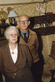
Photograph - Coloured, C 1955-56
The couple are May & David Mitchell in the front room of their holiday shack called "The Holiday Hut" - built by E.C. Mitchell of Stawell at the site of the Borough Huts. See Rec 586 for more information.The photo shows a man and a woman standing in a room. The walls have been papered. A double shelf behind the man has a china jug/vase on the top section and glasses on the lower one. Two lamps stand on the mantle shelf behind the couple. Both people are wearing glasses and the woman is wearing a cardigan with a cream blouse with a brooch. The man is wearing a tie, shirt and zipped cardigan.buildings, houses -
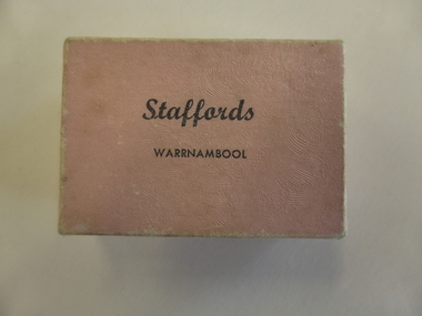 Warrnambool and District Historical Society Inc.
Box, Jewellery Box, Mid 20th century
This is a jewellery box from the Warrnambool business of Stafford, the jeweller. The Staffords shop was at 120 Liebig Street and operated in the 1960s, 70s, 80s, 90s and early 2000s. The site is still a jewellery shop. This box is of minor interest as an example of a small jewellery box from the mid 20th century.This is a small cardboard box covered with salmon-pink paper on the outside. It is empty but once contained an item of jewellery. The pink paper is slightly buffed. ‘Staffords Warrnambool’staffords, jewellers, warrnambool, jeweller box -
 Eltham District Historical Society Inc
Photograph, Environmental Parade, Main Road, Eltham, c.Jan. 1988
Max Davies Service Centre is the present day site of Healthability Eltham, renamed 27 November 2019 as the Rosemary Aitken building (https://healthability.org.au/hero-of-health-is-honoured-in-building-naming/)35mm colour positive transparency (1 of 7) Mount - Kodak KodachromeProcess Date JAN 88Meltham, healthability, main road, max davies service centre, montessori school, parade, roads, rosemary aitken building -
 Eltham District Historical Society Inc
Photograph, Margaret Ball, Jock Read outside home, 54 Henry Street, Eltham, c.Anzac Day 2000, 25 Apr 2000
The adjoining block at no. 52 was not developed at the time. Since Feb 2014 (most recent Google Street View as of Jan 2018), both sites have been bulldozed and new developments built.The Margaret Ball (Pre 1960s Houses) Collection was a personal project initiated to mark the year 2000 and arose as a result of the disappearance of many pre-1960s parts of Eltham due to development. Approximately 200 pre-1960s style houses that were left in Eltham between Main Road and east to Bible Street, between Cecil Street to the north and south to Dalton Street were photographed in late 1999. Not all of the houses could be photographed; some because the garden or trees blocked the view of the house, others because of rubbish or cars were in the way, some because people were working on the house or in the gardens at the time.Colour photographic printeltham, houses, streets, margaret ball (pre 1960s houses) collection, henry street, jock read, lofty (horse) -
 Eltham District Historical Society Inc
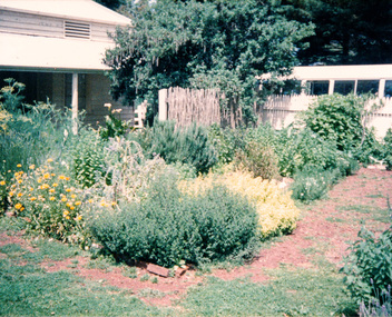
Photograph, Margaret Ball, Shillinglaw trees, site of former Shire of Eltham offices and prior to that the original site for Shillinglaw Cottage, 895 Main Road, Eltham, 1999
The adjoining block at no. 52 was not developed at the time. Since Feb 2014 (most recent Google Street View as of Jan 2018), both sites have been bulldozed and new developments built.The Margaret Ball (Pre 1960s Houses) Collection was a personal project initiated to mark the year 2000 and arose as a result of the disappearance of many pre-1960s parts of Eltham due to development. Approximately 200 pre-1960s style houses that were left in Eltham between Main Road and east to Bible Street, between Cecil Street to the north and south to Dalton Street were photographed in late 1999. Not all of the houses could be photographed; some because the garden or trees blocked the view of the house, others because of rubbish or cars were in the way, some because people were working on the house or in the gardens at the time.Colour photographic printeltham, houses, streets, margaret ball (pre 1960s houses) collection, shillinglaw trees, shillinglaw cottage, eltham shire office -
 Eltham District Historical Society Inc
Photograph, Churchill Island, Spring Excursion, 22 November 1987, 22/11/1987
Churchill Island is a small island adjacent to Philip Island. It is the site where James Grant planted the first crops in Victoria in 1801. It also contains other features of historical and environmental interest.Six colour photographsactivities, churchill island -
 Eltham District Historical Society Inc
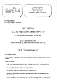
Newsletter, No. 112 January 1997
Contents: • Next meeting, Eltham on Video • 1997 Program • Former Eltham Shire Office Site – Planning Appeal • The “Shillinglaw Trees” • Yarra River Punt, Warrandyte • Annual General Meeting The Shire of Eltham Historical Society was formed in October 1967. The first newsletter of the Society was issued May 1978 and has been published continuously ever since on a bi-monthly basis. With the cessation of the Shire of Eltham in late 1994, the Society's name was revised to Eltham District Historical Society and this name first appeared with issue No. 103, July 1995. The collection of the Society's newsletters provides a valuable resource on the history of the Society's activities, office bearers and committee members, guest speakers and subjects of historical interest pertinent to the former Shire of Eltham and the Eltham District.A4 photocopied newsletter distributed to membersnewsletter, eltham district historical society, shire of eltham historical society -
 Port Melbourne Historical & Preservation Society
Photograph - 64 Evans Street, Port Melbourne, Jack GOULD, c. 1950
This was the second house built by Caleb Kennett on this site. His was the first house in Evans Street, 1868. At turn of 21st century, home of Jenny and Noel Turnbull. Copied from Gould collection.Lasercopy of photo of 64 Evans Street and surrounding area (bird's eye view), originally home of abattoir owner Caleb Kennett..built environment - domestic, caleb kennett, noel turnbull, jenny turnbull, jack gould -
 Charlton Golden Grains Museum Inc
Photograph, Charlton Post Office 1987
First Post Office established in Camp St in 1878. Rebuilt on current site in 1879, current Post Office built 1940. Photo part of a Charlton Shire streetscape series 1987.Colour photo of Charlton Post Office. Red brick single storey building. Clock above entrance shows 5 minutes to nine. Yellow combi van, tree and public telephone on LH side of photo. Street light and rubbish bin on right of entrance. Signage above entrance says Post Office Charlton, ER and crown above the clock. Brown fence to right of building,charlton post office -
 Clunes Museum
Photograph - PHOTOGRAPH PLAQUE AT SWIMMING POOL, 1987
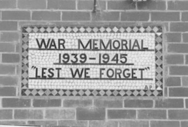
WAR MEMORIAL PLAQUE DESIGNED AND MADE BT ARTHUR PICKFORD, BUILD INTO WALL OF ORIGINAL DRESSING ROOM AT VICTORIA PARK BUILDING DEMOLISHED FEB. 1987 TO PREPARE SITE FOR COMMUNITY COMPLEX.COLOUR PHOTOGRAPH PLAQUE AT CLUNES SWIMMING POOL CHANGE ROOMS DEMOLISHED 20,2, 1987.BUILDING - FOOTBALL / CRICKET CLUB AT VICTORIA PARK.photographs, plaque at swimming pool -
 Clunes Museum
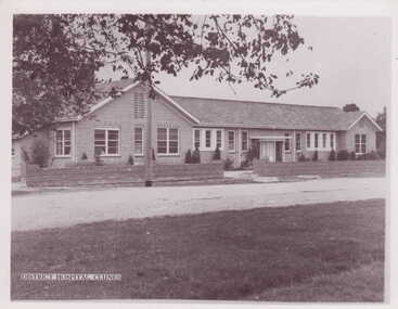
Photograph - PHOTOGRAPH CLUNES HOSPITAL
CLUNES HAS HAD A HOSPITAL SINCE LAST CENTURY. RE-MODELLED IN 1937 - BURNT IN BUSHFIRE IN 1944. NEW BUILDING AND SITE BUILT IN 1947. NOW USED AS COMMUNITY HEALTH CENTRE.BLACK AND WHITE PHOTOGRAPH OF "NEW" CLUNES HOSPITAL ON SERVICE STREET, CLUNES. LIGHT POLE IN FOREGROUND - LARGE ELM TREE TO LEFT. SHRUBS IN GARDEN BEHIND FRONT BRICK FENCE.local history, photography, photographs, hospital -
 Whittlesea Historical Society Inc.
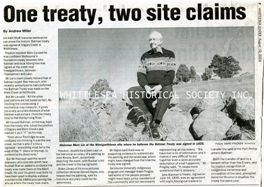
Newspaper - Article, Whittlesea Leader, One treaty, two site claims, 10 Aug 2004
Amateur historian Merv Lia believes Melbourne's foundation treaty between John Batman and the local aborigines was signed in 1835 at the Edgar's Creek site near Westgarthtown, between Thomastown and Lalor.A4 1 p. black and white newsprint with imagemerv lia, thomastown history, john batman treaty, edgar's creek, westgarthtown, batman treaty -
 Melton City Libraries
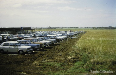
Photograph, West Melton Regional Shopping Centre, 1973
Kilpatrick house which stood on the site until the 1970s on the land now occupied by the Regional Shopping Centre later to be renamed Woodgrove. Opening of the Centre views from the parking areas and paddocksOpening of the West Melton Regional Shopping Centre taken from the carparklocal significant events, local identities -
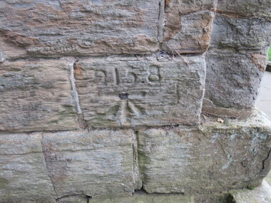 Ballarat Heritage Services
Digital Photograph, Stonemason's mark, exterior wall, Durham Cathedral, UK, 21 October 2016
Durham Cathedral is on a World Heritage Site, and the first stones were thought to be laid around 1000 - 1100 AD. Thus many marks in the stones in this cathedral are thought to date from this time. -
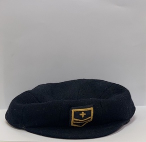 Mentone Grammar School
Earliest Mentone School Cap, 1920-1922
The navy cap represents the earliest period of Mentone Grammar’s history (1920-22) under Headmaster John Aubrey Ball. This was prior to the School’s foundation, in 1923, at the present site on Venice Street -
 Surrey Hills Historical Society Collection
Archive - Vertical file, Surrey Hills Baby Health Centre
The Baby Health Centre opened in the Surrey Gardens in 1930 on the site previously occupied by the screen for outdoor pictures. Previously during the 1920s it had operated in the room underneath the rotunda in the Surrey Gardens.A vertical file of information related to the baby health centre in the Surrey Gardens: 1. ‘Surrey Hills baby health centre’ photo in ‘The Argus’, 2.6.1930 (1 page). 2. ‘Surrey Hills big day’ ‘The Reporter’, 6.6.1930 (1 page). 3. ‘Health association disbands’, ‘Progress Press’, 11.12.1974 (1 page). 4. ‘The Surrey Hills baby health centre – Surrey Gardens’: notes obtained by Mrs Daphne Wisewould in discussion with committee members, c. 1975 (1 page). 5. Copy of letter from City of Camberwell to Mrs. C.T. Lancashire, 10.2.1975 (1 page). 6. Handwritten copy of No. 4 (3 pages). 7. Handwritten ‘A now story for 1981’, Mrs. Dorace Lancashire (1 page). 8. Typed copy of No. 7 (1 page). 9. Precis history compiled by Susan Barnett from information provided by Mrs. D. Lancashire (1 page). surrey hills baby health centre, infant welfare, maternal and child health, (mrs) daphne wisewould, (mrs) dorace elizabeth lancashire, (mrs) cyril thomas lancashire -
Lakes Entrance Regional Historical Society (operating as Lakes Entrance History Centre & Museum)
Photograph, Lakes Post Newspaper, 1/11/1999 12:00:00 AM
Also two other colour photographs taken at the Reconciliation Ceremony at Lake Tyers numbers 04129.1 and 04129.2 size 10 x 15 cm. Fifteen recorded sites of aboriginal massacarsColour photograph of Reconciliation Ceremony at Lake Tyers Victoriaaboriginals -
Lakes Entrance Regional Historical Society (operating as Lakes Entrance History Centre & Museum)
Photograph, J Brookes, 1889
Also a colour photograph taken from Merrangbaur hill of warm holes and dunes and ocean approximate site of original entrance taken in 1995 04276.1 size 10 x 15 cmBlack and white photograph taken from Roadknights Merrangbaur property looking towards the natural entrance, seven people sitting or standing on brow of hill Lakes Entrance Victoriaclubs, recreational facilities -
Lakes Entrance Regional Historical Society (operating as Lakes Entrance History Centre & Museum)
Photograph, K Scarce, 1989
Also two colour photographs at various stages of demolition. Sold for site development after amalgamation of Methodist and Presbyterian to become Uniting Church 04562.1 and 4562.2 10 x 15 cmColour photograph taken at start of demolition of Bairnsdale Methodist church and hall service Street Bairnsdale Victoriahistoric buildings -
 Lakes Entrance Regional Historical Society (operating as Lakes Entrance History Centre & Museum)
Photograph, Holding M, 2000
Private residence built 1925c for Frank Harbeck|Also Two other colour photographs showing two brick chimneys left standing until site cleared for construction of holiday accommodation.Colour photograph of a dwelling at 55 Church Street, prior to demolition. Weatherboard building, iron roof, gable projection. NW and SE corners, gable ventilator in centre roof, veranda on two sides. Bay window across corner of front room. Lakes Entrance Victoriahouses, township -
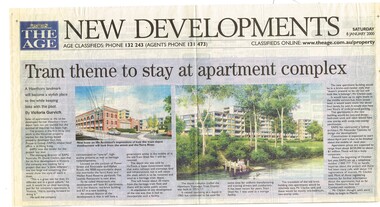 Melbourne Tram Museum
Newspaper, The Age, Progress Press, "Tram theme to stay at apartment complex", 2000
Set of 6 newspaper cuttings about the redevelopment of the site to apartments and the Hawthorn Tram Museum Depot. .1 - The Age - 8 Jan. 2000 - "Tram theme to stay at apartment complex" - announcing the redevelopment and plans for the redevelopment of Hawthorn tram depot. Includes architects impressions. Article by Victoria Gurvich. .2 -The Age - 14/1/2000 - letter to the Editor by Peter Moon - "Tram plan: too big and too ugly". .3 - Press - 21/2/2000 - "Trams on track for 498 years, Depot housing in line with history" - with photo of Mike Ryan and Matt Faubel (old photo) - article by Laeta Antonysen. .4 - ditto - "Outcry over historic site" and "Developers asked for another aspect" .5 - Progress Press - 6/3/2000 - letter re the redevelopment from John Santoro or Power St Hawthorn. .6 - Progress Press - 7/8/2000 - "Green light for tram depot apartments" - about the City of Boroondara issuing the planning permit.trams, tramways, hawthorn tram depot, tram museum, museums, minister for transport, city of boroondara -
 Bendigo Historical Society Inc.
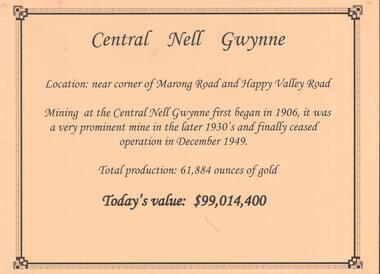
Document - CENTRAL NELL GWYNNE GOLD MINE
Interpretive sign and 4 photos Central Nell Gwynne Gold Mine, used in display. Central Nell Gwynne was located near the corner of Marong Road and Happy Valley Road. Opened in 1906, ceased operation in December 1949. Total production: 61,884 ounces of Gold. Today's Value: $99,014,400. Photos: a. Colour photo, concrete footings at mine site, April 2012. b. Colour photo, Central Nell Gwynne poppet head, April 2012.Poppet head painted white with red trim. Concrete footings in foreround. c. Central Nell Gwynne mine site 1930's. Poppet head and engine room sheds on LH side, trestle way to primary crusher and crushing battery. Tailing dam in immediate foreground. on RH side. Sand heaps in middle foreground. d. Central Nell Gwynne Mine 1930. Underground view, men holding carbide lamps working at 265 level in mine. Large quartz spur formation visible in foreground.bendigo, mining, central nell gwynne -
Bendigo Historical Society Inc.
Document - VICTORIA HILL - THE BENDIGO DIGGINGS, PRELIMINARY DRAFT FOR BROCHURE
Nine typed pages of notes on a preliminary draft for a brochure on the Bendigo Diggings. First part is the objective which is to preserve the mining history and to have exhibits in the places they were used, e.g. quartz mining machinery exhibited in a quartz mining area, not on an alluvial field. Part B is historical notes on the area. Part C is the Site - Victoria Hill area. Part D is Stage One which consists of carpark area, technological museum, restaurant, mineral haulage line, picnic ground, earthworks and planting over the area. Part E is Stage Two which will consist of the open-air exhibits, in the area surrounded by the mineral haulage line, and the Central Nell Gwynne mine on the west side of the site. Part F is Stage Three which will consist of the winery, the steam tram track, the lake, the wildlife sanctuary and various buildings associated with gold mining. Part G is Costing with the prices to be filled in. Parts H and I are the Appeal and the Committee. Details to be filled in.mining, marketing, victoria hill, victoria hill, the bendigo diggings - preliminary draft for brochure, aust national travel association, tullamarine jetport, emu bottom homestead, kyneton historical museum, chinese joss house, eaglehawk museum, whipstick scrub, cairn curran reservoir, castelmaine historical museum and market hall, national trust, ballarat hiatorical park, echuca's hopwood gardens, swan hill folk museum, gibson's mount alexander no 2 squatting run, captain brown, chief commissioner wright, hustler's reef, thomas hustler, mining board, drainage of reefs act 1862, first world war, bendigo amalgamated goldfields, second world war, sandhurst, w c vahland, battery trams, horse trams, steam trams, electric trams, central nell gwynne mine, theodore ballerstadt, george lansell, new chum hill, ballerstadt's open cut, 180 mine, new chum syncline battery, william rae, victoria quartz, wittscheibe's 'jeweller's shop', luffsman and sterry, gold mines hotel, adventure, bendigo and district tourist association, bendigo city council, bendigo branch of the royal historical society of victoria, professor brian lewis, school of architecture and building at the university of melbourne, taylor horsfield, lord robert cecil, south australian gold commissioner -
 Ringwood and District Historical Society
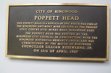
Plaque, City of Ringwood replica Antimony Mine Poppet Head commemorative plaque - 1987, 1987
Installed 12-April-1987 on the poppett head near the Ringwood Lake. It was removed c.2005.Plaque 'City of Ringwood/ Poppett Head' embossed. +Additional Keywords: Rosewarne, Lillian, Cr'City of Ringwood/ Poppett Head/ This Poppett head is a replica of one which was used at/ the Ringwood Antimony Mine located at the present/ Civic Centre Site, Mines Road, Ringwood east./ The Poppett head was erected by the/ Ringwood City Council, in conjunction with the/ Ringwood Historical Research Group, and was/ commissioned by the Mayor of Ringwood/ Councillor Lillian Rosewarne, JP/ on 12th April 1987/ -
 Ringwood and District Historical Society
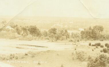
Photograph, Ringwood Birdseye - Looking towards Ringwood from later site of Civic Centre in Braeside Avenue, Ringwood East
Typed below photograph, "Looking towards Ringwood from present site of Civic Centre. Old Catholic Church which stood on Maroondah Hwy. and Mt. Dandenong Rd. intersection can be seen on right. Maroondah Hwy. can be seen where it goes past lake, also station masters residence, and houses in Pitt St. and Bedford Rd." -
City of Moorabbin Historical Society (Operating the Box Cottage Museum)
Document - Tenth Anniversary - Presbyterian Church East Bentleigh, 1957 - 1967, 1967
Presbyterian Church East Bentleigh, built in 1957 in Cecil Street East Bentleigh. The site and building is now (2022) being used by Chabad, Bentleigh, which serves to cater to the needs of the Jewish Community.Presbyterian Church Bentleigh was formed to cater for the growing population of Bentleigh when the market gardens were subdivided into residential blocks.Document with blue cover, 18 pages. Contains text and pictures.parish of moorabbin, city of moorabbin, county of bourke, shire of moorabbin, market gardeners, presbyterian church east bentleigh, cecil street, east bentleigh, subdivision of land, religion -
 Greensborough Historical Society
Photograph, Home of Bill and Dot Splatt, 1945c
From accompanying typed caption: "Home of Bill and Dot Splatt. Purchased approx 1915-1918 and stayed in the family until mid 1950s. 37 Grimshaw Street Greensborough - site of Methodist Church."This home was demolished for the site of the 'new' Greensborough Methodist Church. Copy of Black and white photograph. Copy 2 printed Item 1054.Caption is typed.methodist church greensborough, grimshaw street, splatt family