Showing 5324 items
matching timbering
-
 Whitehorse Historical Society Inc.
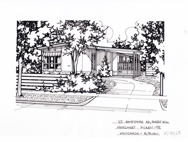
Artwork, other - Ink Line Drawing, Margaret Picken, 25 Hampshire Rd., Forest Hill, 1995
A property illustration by Margaret Picken Commissioned by the real estate agency Woodards Blackburn for the purpose of advertising 25 Hampshire Rd., Forest Hill. This property is listed as having sold for $104,000 in 1996. Since the time of sale in 1996 the house on the property has been demolished and a new house built on the site. Made by using Rotring ‘Rapidigraph’ drafting pens with Rotring ink on Rapidigraph polyester drafting film, double matte. Trained as a cartographic draftsman within the mining industry, Margaret Picken is an artist who worked producing property illustrations for real estate agencies in eastern suburbs of Victoria from 1983-2005. Retiring from the industry as technological changes favored coloured photography over illustrations, and commissioning companies over sole contractors.This artwork is of Historical Significance as a record of local domestic architecture.A black ink line drawing on drafters film by Margaret Picken, of 25 Hampshire Rd., Forest Hill. Depicting in the foreground a horizontal timber plank fence on the left, and a curving driveway on the right leading to a connected carport. In the background is a small house. There are two hole punch holes just right of centre on the upper edge. There is a 0.5x0.5 mark on the top half of the right edge25 Hampshire Rd., Forest Hill Margaret Picken - 95 Woodards B/Burnwhitehorse historical society, schwerkolt cottage, housing, architecture, margaret picken, house, garden, forest hill -
 Bendigo Historical Society Inc.
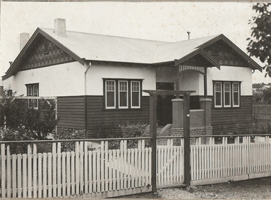
Photograph - T C WATTS & SON COLLECTION: 93 NEALE STREET, BENDIGO, 1929
BHS CollectionBlack and white photographs (2) mounted on rectangular grey board. House, weatherboard and rougheast, corrugated iron roof, 2 chimneys, decorative gables, porch with brick, render and timber pillars, wood slat fence with capping board, gate with lintel over, established garden. On back of photoboard " A. McDonell, Neale and ....... Streets, £1050 sewered' 2012 photo of house attached to record.Frank A. Jeffree, Bendigoresidential, t.c. watts and son, a. mcdonnell, neale street, bendigo -
 Lakes Entrance Historical Society
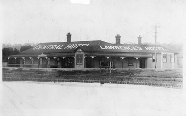
Postcard - Central Hotel, 1924c
Central Hotel, showing a large single storey building, three chimneys with chimney pots, veranda across the front divided from side veranda by protruding gable. Iron roof, bull nosed veranda roof. Sash windows. Bluestone wall along edge of lake. Sign 'To Public Hall' on corner. Lakes Entrance VictoriaBlack and white postcard of timber Central Hotel, showing a large single storey building, three chimneys with chimney pots, veranda across the front divided from side veranda by protruding gable. Iron roof, bull nosed veranda roof. Sash windows. Bluestone wall along edge of lake. Sign 'To Public Hall' on corner. Lakes Entrance Victoriahotels, architecture, accommodation -
 Flagstaff Hill Maritime Museum and Village
Photograph - Historical, Flagstaff Hill, Harbourmaster’s Quarters, 1970s
The photograph shows a cottage, Harbourmaster’s quarters that still stands on the east of the Lady Bay Lighthouse and Historic Precinct at Flagstaff Hill in Warrnambool. The name was changed to the Lighthouse Lodge, and today guests can stay at the property. This photograph, a print, is one of a set of five that show the site of Flagstaff Hill. It is presumed to have been taken by John Lindsay, Founding Director of Flagstaff Hill Maritime Museum and Village. One of the photographs in the set has the pencil inscription "Photo J Lindsay". It was taken in the early 1970s during the initial stages of the development of Flagstaff Hill as a Museum and Maritime Village. The photographs belonged to the donor's grandparents, who lived in the Warrnambool district of Allansford/Naringal. The photograph is a record of the site and surrounds of Flagstaff Hill Maritime Museum and Village before its development and opening in 1975. It shows the cottage on the east of the Lighthouse Complex,. The building is now known as Lighthouse Lodge. The photograph is significant for recording the location and condition of the residence on the Hill.Coloured photograph, glassy print, one of a set of five. Photograph shows the cream timber cottage, Harbourmaster’s quarters to the east of the lighthouse complex at Flagstaff Hill, Warrnambool. On the left of the red roofed residence are iron buildings used, at the time, by the Lands Department. The photograph's paper has the printer's watermark on the back. The early 1970s photograph is presumed to have been by John Lindsay, Warrnambool.Label on the back: "WOODEN RESIDENCE TO THE EAST OF THE PROPERTY / The gun emplacements are immediately behind, and the iron huts to the left rear of the residence are used by the Lands Department who plan to vacate, for other premises."flagstaff hill, flagstaff hill maritime museum and village, warrnambool, maritime museum, maritime village, great ocean road, shipwreck coast, 1970s, photograph, flagstaff hill site, john lindsay, cannon emplacement, residence, wooden residence, timber residence, iron huts, lands department -
 Bendigo Historical Society Inc.
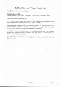
Document - PADDY'S GULLY LINE - VIRGINIA CONSOLS MINE
Handwritten page of notes on the Virginia Consols Mine on Paddy's Gully Line of Reef. Notes mention shaft being cleaned out and timbered to 100 ft. Also depth of work, timbering and geological features. Also a small piece of paper with:- Virginia Consols Mine 2 miles North of E'hawk Town Hall. Paddy's Gully Line. Notes prepared by Albert Richardson.document, gold, paddy's gully line, paddy's gully line, virginia consols mine, e'hawk town hall -
 Lakes Entrance Historical Society
Photograph - Bridges, 1990
Also another photo taken laterColour photograph showing McKillops Bridge across the Snowy River in the High Country near Deddick, East Gippsland near the Victorian / NSW border, south side of bridge, road to Deddick just visible opposite end, taken from west end of bridge. River flowing to right, bridge of timber, steel and concrete, mountains around. East Gippsland Victoriabridges, waterways, topography -
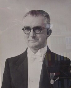 Glenelg Shire Council Cultural Collection
Photograph - Photograph - Councillor Arthur J. Thomas, Mayor 1951-1953, c. 1950
Portland Town CouncilFront: Bottom centre: Councillor Arthur J. Thomas, Mayor, 1951-1953 Back: Top left: yellow sticker, numbered 3506.arthur j thomas, mayor, mayor of portland, civic photography -
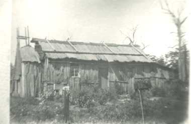 Lakes Entrance Historical Society
Photograph - Bark hut at Lake Tyers area Victoria, Bark hut at Lake Tyers area Victoria, 1900 c
Second identical copy 04618.1Black and white photograph of a bark hut showing walls of vertical sheets of bark held in place by horizontal battons. On the roof overlapping sheets of bark are held in place by a horizontal log attached to the saddle pole on the roof ridge by vertical timbers. Nails were not used wooden pegs or greenhide strips kept the frame stable. This building believed to be in the Lake Tyers area Victoriahouses, land settlement -
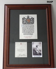 Bendigo Military Museum
Memorabilia - MEMORIAL SCROLL, KINGS LETTER, PHOTO WW1, ITEMS WW1
Refer Cat No 2351.5P David James HAMILTON, 329 14th BTN, WIA twice KIA 7.6.1917, 12th M.G.Coy, Buried Strand, Military Cemetery, Ploegstreet, Belgium Collection of three items framed. Photograph- copy of black and white photograph- half portrait of a soldier in uniform Commemorative scroll- original scroll, printed in black and red ink, with colour to coat of arms. Coat of Arms of King George V on paper Frame- brown colour stain timber with decorative moulding. Dark green cardboard mount, glass front, cardboard back.photographs, frame, accessories, documents, certificate -
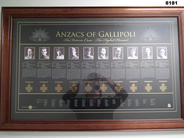 Bendigo Military Museum
Photograph - VC ANZACS OF GALLIPOLI, FRAMED, Unknown
The Gallipoli Anzacs from left. - right. Albert Jacka, Cyril Bassett, Leonard Keysor, Alexander Burton, William Dunstan, Patrick Hamilton, Alfred Shout, William Symons, Harold Tubb, Hugo Throssell. This item is on display in the Bendigo District RSL Havilah Road.Framed photographs, frame is timber, photos and text are set in a dark green background, at the top centre between two images of Rising Sun badges is “ANZACS of GALLIPOLI” followed by “The Victoria Cross - The Highest Honour”. There are 10 photos in a row with text under each one with their details, under each is an image of a Victoria Cross. At the bottom is a list of the Australian and New Zealand Victoria Winners.brsl, smirsl, bdrslinc, victoria cross -
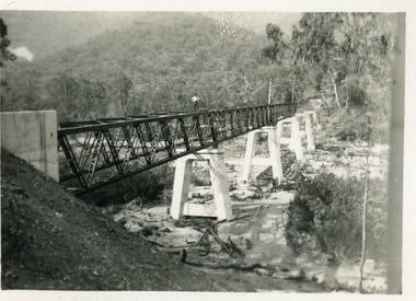
 The Beechworth Burke Museum
Photograph, c. 1927 - 1930
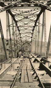
Taken during the construction of the Bethanga Bridge (1927-1930), this sepia photograph shows a view of the incomplete bridge taken from inside the structure and looking down the span of the bridge from where the photographer stands. The photograph depicts an incomplete deck, with loose-looking wooden planks/panels lain along the centre in groups of three. Once complete, the original decking of the bridge was made of timber before being replaced by cement in 1961 (Victorian Heritage Database).Bethanga Bridge is of historical significance to the Indigo Shire for its associations with the construction of Hume Dam, its associations with the River Murray Waters Agreement and the River Murray Commission, and illustration of the needs and influence of the farming communities along the river in this area - particularly in relation to the building of the Weir. It also represents the collaboration between New South Wales and Victoria on a large infrastructure project, being the only built structure shared by both New South Wales and Victoria due to its location. also reflecting on the Shire's geographical closeness to this neighboring state. This photograph is part of a series that documents the construction of this well-known heritage site of significance to the Indigo Shire. It reflects upon a period of growth and change in the area.Sepia, rectangular photograph printed on matt photographic paper, unmountedReverse: 1997.3190 / Another snap of the bridge. taken on the bridge showing huge steel sides / 84-19-4 / V [in circle] 354 / KODAK PRINTbethanga bridge, hume dam, bridges album, construction, road construction, hume weir -
 Eltham District Historical Society Inc
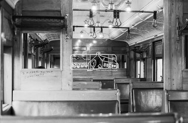
Photograph, George Coop, Interior of a Red Rattler Tait train passenger carriage, 22 August 1983, 1983
Note the graffiti. Older 20th.c and earlier railway cars were rolling palaces of the cabinet makers art. Full of polished timber, plated & embossed metal fittings, soft upholstery & beveled glass. In their earliest form, the Tait’s and earlier swing door cars for even modest suburban work, reflected some level of this design approach. Plus of course large sepia toned photographs on dividing walls displaying tourist spots trains could take you to.Digital TIFF file Scan of 35mm Kodak Safety 5062 black and white transparencygraffiti, interior, passenger carriage, red rattler, tait train -
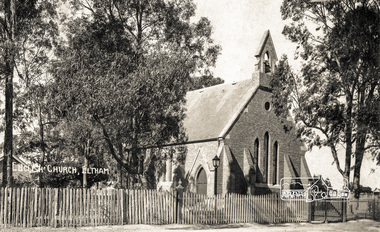 Eltham District Historical Society Inc
Photograph - Photograph postcard, English Church, Eltham, c.1920
St. Margaret's Church of England, Pitt Street, Eltham. Early photo showing timber picket fence. Written on the back of the postcard: "Today is the Glamorgan Fete. A lovely sunny day. The crowd is here to spend their cash. And everyone is gay. We are all glad to see you here And for th school we give a cheer!" Glamorgan was a kindergarten in Toorak during the 1920s and is now part of Geelong Grammar Schools Preparatory School Glamorgan Campus, Toorak.Digital file only Postcards scanned from the collection of Michael Aitken on loan to EDHS, 13 Feb 2018michael aitken collection, postcards, eltham, pitt street, st margaret's anglican church, church, church of england, english church, st margarets anglican church, st margarets church, glamorgan fete -
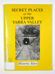 Marysville & District Historical Society
Book, Secret Places of the Upper Yarra Valley-Historic Sites, 1994
A book describing historic sites in the Upper Yarra ValleyPaperback. Front cover has a black and white photograph of a railway tunnel at Healesville.A collection of places within the Upper Yarra/ Valley significant to the understanding of our/ heritage./ Aborigines, white explorers, pastoralists, gold/ miners and timber cutters have all left their mark./ These are sites which, despite modern/ development and urbanisation of our valley, are/ still able to give us an insight to an eventful past. Stamp of Marysville & District / Historical Society Inc / P.O. Box 22 / Marysville 3779upper yarra valley, history, historic sites -
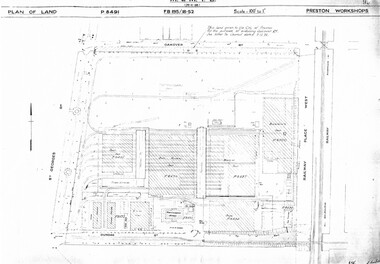 Melbourne Tram Museum
Drawing, Melbourne & Metropolitan Tramways Board (MMTB), "Preston Workshops", c1938
Set of nine photocopied plans or drawings on A3 sheets of the "Preston Workshops" - c1939 .1 - P8491 - Plan of land showing layout and associated drawings including Reservoir railway line - 19-4-1939. .2 - P8492 - Plan of Timber stacks and Hall - 3-2-1939 .3 - P8493 - Plan of Offices and location of sub-station - 13-12-1938 .4 - P8494 - Plan of Store including Oil store - c1939. .5 - P8495 - Plan of Paint Shop and relationship to timber stack - 1-3-1939 .6 - P8496 - Plan of Car building and Repairs shop - 6-12-1938 .7 - P8497 - Plan of machine shop - 10-12-1938 .8 - P8500 - Plan of Blacksmiths shop - 1-12-1938 .9 - P8590 - Plan of Substation - 1-12-1938trams, tramways, drawings, depots, property, preston workshops, workshops, substation -
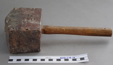 Upper Yarra Museum
Mallet, Wooden
A wooden Mallet could be found in most homes, and nearly all tradesmans tool box or bag, its most common use was working with wooden handled wood Chisels, because they did not damage the end of the chisel like a steel headed hammer,also they were used to fit joints of wood together as they would not damage the timber like steel hammers......Wooden mallets were also used by stone masons back to the time of the pyramids, but they were usually shaped differentlyWooden Mallet A handmade wooden mallet with a handle with a rectangular head. Carved ET on sidewood, mallet, tradesman, carpenter, cabinet maker -
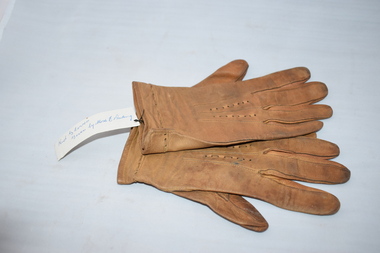 Warrnambool and District Historical Society Inc.
Gloves, Kid gloves Mrs Ponting, Early to mid 20th century
These gloves were donated by Miss E. Kerr of Warrnambool and were probably worn by her. The Ponting family has been prominent in the timber and building business in Warrnambool since the 1920s and still operate today. Miss Kerr was a member of the Warrnambool and District Historical Society in the 1970s and donated many items, especially household goods. Many women in the early to mid 20th century owned leather gloves which they wore mostly with suits and coats in the winter time. They can still be purchased today. These gloves are of interest as an example of the type of gloves worn by women in the 20th century. They will be useful for display.These gloves are made of a light brown leather. They have a leather string lace inserted as a decorative pattern on the wrist openings and the same lacing on the upper sides of the gloves but in this area the leather string is missing. The gloves have been much worn and are stained. women’s accessories, history of warrnambool -
 Eltham District Historical Society Inc
Negative - Photograph, Mr Belot smokes his pipe whilst resting at Cottle's Bridge, c.1990 (c.1890)
Copy of original photograph. The area, previously known as Back Creek, was named after Thomas Cottle, who settled in the district in the 1870s, and the original bridge over the Diamond Creek on the road to Strathewen. The original bridge (seen in the photo) was replaced with a new timber bridge at a cost of £1,500, the tender being awarded to a contractor named Birch who commenced work in June 1927. The gentleman in the photo who is resting whilst having a smoke of his pipe is a member of the Belot family.Roll of 35mm Black and White negative film, 3 strips, (1 of 14 frames)Film - Agfa Ortho 25belot, bridge, cottles bridge, cottles bridge-strathewan road, diamond creek (creek), heidelberg-kinglake road -
 Greensborough Historical Society
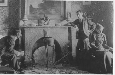
Photograph - Digital image, Saxam interior, 1896_
'Saxam' was the home of the Kaye family (1886-1888) then William Santon, a former councillor and Mayor of Heidelberg. Saxam Homestead is a distinctive and substantial timber homestead built in the late 1880s as one of the notable rural properties in the St Helena area. [Photo G. Studley]. Seated are Mr and Mrs Kaye, standing William Santon who was a local footballer, councillor and later Mayor of Heidelberg. In 2014 the house still stands but is in poor condition with most interior features such as this fireplace removed. Digital copy of black and white photograph.saxam, william santon, santon family -
![Photograph - Digital image, Iredale Family 1 [man and woman], 1890c](/media/collectors/4f729f5697f83e03086015b8/items/5455cc332162f10d64fa5bbd/item-media/5455cc5f2162f10d64fa6013/item-fit-380x285.jpg) Greensborough Historical Society
Greensborough Historical SocietyPhotograph - Digital image, Iredale Family 1 [man and woman], 1890c
Photograph of members of the Iredale family - George Iredale and Anna Marie [nee Gilding]. In 1858, James Iredale owned the General Store in Main Street Greensborough, when it became the Town’s Post Office. The Farmers Arms Hotel was built on the corner of Main and Hailes Street in 1864 by George Iredale to cater for the ever increasing number of wood carters and other hauliers carting their wares between Melbourne, timber mills and the gold fields. The Farmers Arms Hotel is currently the site of the Greensborough Hotel. Digital copy of black and white studio photograph.james iredale, george iredale, farmers arms hotel -
 Orbost & District Historical Society
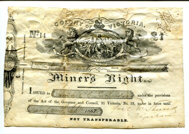
Certificate, September 1867
Following a Royal Commission in 1855, the Gold License was changed to the Miner’s Right, which reduced the fee and required annual payment, rather than monthly or quarterly.The fourth Goldfields Act, passed in early 1858, gave increased privileges to holders of Miner's Rights. These included the right to make residential claims, allowing the cutting of timber on claims and giving the right to build races and dams on any crown lands for mining purposes. This certificate is in the name of Samuel Richardson who brought it to Orbost.This item is of historical significance as it is associated with positive outcomes for gold miners brought about by the Eureka Stockade rebellion and its subsequent democrat changes. It is also associated with the Richardsonfamily who were early settlers in Orbost.A certificate for a miner's right printed on paper. It cost one pound. It was Not Transferable. Details have been filled out in ink. At the top of the licence is an elaborate etching, under the heading 'Colony of Victoria'. Inside a shield is a young woman, crowned, seated, with shipping in the background. oO her left is a miner with hat presenting her with a gold nugget while on her right, a farmer presents grain to her. Mottoes include 'Honi Soit Que Mal Y Pense'; 'Dieu et Mon Droit' and 'Advance Australia' There are handwritten notes in faded ink on the back.miner's right, colony of victoria, samuel richardson, no 14, government act -
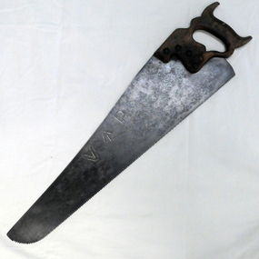 Orbost & District Historical Society
handsaw, C mid 20th century
The Bairnsdale-Orbost railway was opened in 1916 to serve the agricultural and timber industry. Because of the decline in traffic and heavy operating costs, the line was finally closed in August, 1987. Orbost Railway Station was opened on Monday 10 April 1916 as the terminus of the Orbost railway line, and closed in 1987. The station was located on the west side of the Snowy River despite the town of Orbost being on the east side of the river, in order to save on the costs of a bridge over the river, which at the time had highly variable levels. This item is associated with the history of the Orbost-Bairnsdale railway line and therefore reflects the role that the rail line played in the social and economic history of Orbost.A handsaw with a wooden handle and a metal blade with serrated teeth which continue around the nose of the blade.Marked V an upward pointing arrow Rsaw carpentry orbost-bairnsdale-railway orbost-railway-station -
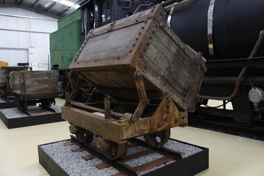 Puffing Billy Railway
Side Tipping Timber Skip, circa 1900?
Side Tipping Timber Skip Wooden Contractors Wagon. Gauge 17 inch (430mm) Typical of the many side tipping wagons used for soil and rock disposal in construction work and mining throughout Australia and the world. The wagon would be loaded with soil and pushed along a short line to the end of track where the load would be emptied out to either side. By using a central pivot the wagon’s body can be tipped either side to allow the contents to be easily removed ready for the next load.Historic - Industrial Narrow Gauge RailwayWooden bodied, steel framed side tipping skip.puffing billy, side tipping skip, industrial narrow gauge railway -
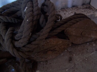 Puffing Billy Railway
Metal Pulley and Rope
Metal Pully and Rope When heavy items were required to be moved a rope and pulley set was very handy. By attaching one end of the set to a solid surface, it was possible to lift items. In the bush, the timber workers made good use of the pulleys. When set up in a sequence, they could move logs across gullys, up and down hills as the chopped down trees made their way to a sawmill. Using animal or mechanical power increased the use of the pulley and rope. Historic - Industrial - Metal Pulley and RopeMetal Pulley and Ropepuffing billy, metal pulley and rope -
 Creswick Campus Historical Collection - University of Melbourne
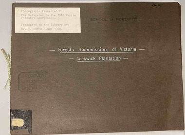
Photograph - Forests Commission of Victoria - Creswick Plantation, 3 booklets of Photographs presented to the delegates to the 1928 Empire Forestry Conference, 1928
This is a folio of photographs of the Creswick Plantations presented to the 1928 Empire Forestry Conference. related to item 1434. 2 additional folios -State Nursery Macedon. Ballarat Botanic Gardens. Photographs of mature specimens of timber trees from the State plantation Creswick, the State Nursery Macedon and the Ballarat Botanic Gardens. Photographs loosely bound into 3 sets. 2 x dark brown loose covers, 1 x dark green loose cover, bound with coloured embroidery thread.PhotographsPresented to the delegates to the 1928 Empire Forestry conference by the Forests Commission of Victoria -
 Stawell Historical Society Inc
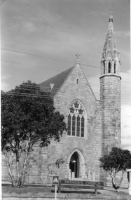
Photograph, St. Patrick’s Catholic Church c 1965-1970
Views of St. Patrick’s Catholic Church. Two of the photos are identical showing the parish hall on left of photo and a small part of priest's residence on right. A car can be seen parked below the church fence. Photo recorded to be taken by Ruby Willy Estate. The other photo shows a different view with a timber sign out the front of the church and two trees either side of the sign. This third photo also just shows the priests house on the right and taken around 1965 -1970.Three black and white photos of St Patrick's Church. Two are identical showing parish Hall on left of photo and small part of priest's residence on right. The other photo of the church taken at a different angle shows two trees and a church sign out the front. Electricity lines can be seen across the photo.stawell -
 Rutherglen Historical Society
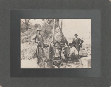
Image, c1890
Photo taken during building of 2nd John Foord Bridge, between Wahgunyah Victoria and Corowa New South Wales. Extracts from the entry for the bridge in the Victorian Heritage Database: "The bridge is of also of historical significance for its association with the prominent local identity and pioneer businessman John Foord, who was involved in the company that erected the 1862 timber bridge on the site. ... When the new bridge was built as a replacement, it took the same name." This second bridge (the current one) was opened in January 1893, Black and white photograph, mounted on cardboard, of four men, one in old style diving suit. diving, wahgunyah, corowa, john foord, bridge construction -
 Ballarat Heritage Services
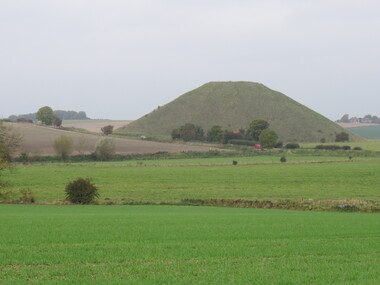
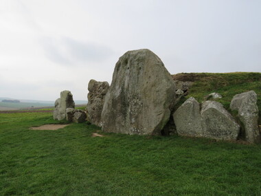
Photograph - Colour, Avebury World Heritage Site, Prehistoric Monuments, England, 2016
Colour photograph of the Silbury Hill, an immense Neolithic man-made mound part of the Avebury World Heritage Site. The Avebury World Heritage Site is a complex of outstanding prehistoric monuments comprising Windmill Hill (Early Neolithic enclosure and Bronze Age burial mounds); Silbury Hill; West Kennet Long Barrow; Avebury Stone Circles and West Kennet Avenue; The Sanctuary (site of stone and timber circles). It is part of National Trust and English Heritage. Visitors may walk to sites.avebury world heritage site, mound, prehistoric monuments, silbury hill, west kennet long barrow, neolithic, world heritage -
 Ballarat Heritage Services
Photograph - Colour, Silbury Hill, Avebury World Heritage Site, Prehistoric Monuments, England, 2016
Colour photograph of the Silbury Hill, an immense Neolithic man-made mound part of the Avebury World Heritage Site. The Avebury World Heritage Site is a complex of outstanding prehistoric monuments comprising Windmill Hill (Early Neolithic enclosure and Bronze Age burial mounds); Silbury Hill; West Kennet Long Barrow; Avebury Stone Circles and West Kennet Avenue; The Sanctuary (site of stone and timber circles). It is part of National Trust and English Heritage. Visitors may walk to sites.Colour photograph of rocks at Avebury World Heritage Site avebury world heritage site, prehistoric monuments, rocks -
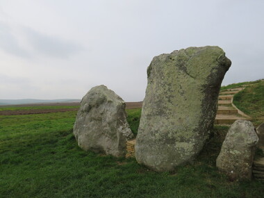 Ballarat Heritage Services
Photograph - Colour, Avebury World Heritage Site, Prehistoric Monuments, England, 2016
Colour photograph of the Silbury Hill, an immense Neolithic man-made mound part of the Avebury World Heritage Site. The Avebury World Heritage Site is a complex of outstanding prehistoric monuments comprising Windmill Hill (Early Neolithic enclosure and Bronze Age burial mounds); Silbury Hill; West Kennet Long Barrow; Avebury Stone Circles and West Kennet Avenue; The Sanctuary (site of stone and timber circles). It is part of National Trust and English Heritage. Visitors may walk to sites.Colour photograph of Avebury World Heritage Stte.avebury world heritage site, prehistoric monuments, rocks