Showing 23236 items matching "smythes-creek"
-
 Eltham District Historical Society Inc
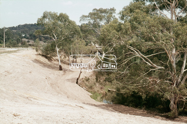
Slide, Construction of Eltham Town Park, 22 Feb 1974
Construction of Eltham Town Park, later renamed Alistair Knox Park. View looking towards Bridge Street and shows the Diamond Creek and formation of the Diamond Creek Trail.35 mm colour positive transparency Mount - Agfacolor Service (Blue)alistair knox park, eltham town park, bridge street bridge, diamond creek -
 Sunbury Family History and Heritage Society Inc.
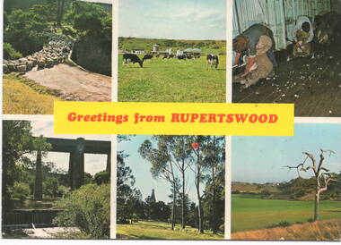
Postcard, Murfett Publishers, 'Rupertswood', C1970s
The post card waas assembled by Salesian College, which is in Rupertswood Mansion. The six images are sites within the Rupertswood Estate and are as follows: Clockwise from L-R- Sheep at the Bridge crossing at Jacksons Creek, Friesan Stud sale, Shearing sheep, Jackson Creek flats, Rupertswood Mansion, Railway bridge spanning Jacksons Creek. Initially Salesian College started as an agricultural school training boys in farm skills. It is now a co-educational secondary college.A postcard with six non-digital photographs of sites within the Rupertswood Estate. Information about each site and the manufacturer's details are on the back of the card.Across the centre of the postcard: GREETINGS FROM RUPERTSWOODrupertswood mansion, salesian college, railway viaduct, jacksons creek, sheep shearing, friesan cattle, sunbury -
 Coal Creek Community Park & Museum
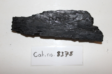
Long shard of coal
Supposedly from Coal Creek.8378.1 - Long, flat, narrow piece of high-grade black coal. Shiny and rectangular in general cross-section. -
 Coal Creek Community Park & Museum
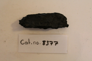
Long coal piece
Supposedly from Coal Creek.8377.1 - Elongate piece of high-grade black coal; rhomboid in cross-section. -
 Coal Creek Community Park & Museum
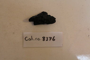
Small angular piece of coal
Supposedly from Coal Creek.8376.1 - small, roughly triangular piece of high-grade black coal. -
 Bendigo Historical Society Inc.
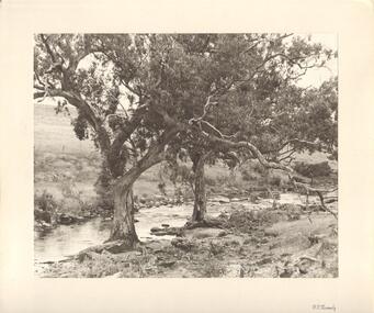
Photograph - TWO LARGE TREES AT EDGE OF CREEK
Black and white photograph. Textured paper of scene on creek, with two attractive trees at water's edge, possibly Bendigo Creek. Sheep in background. Inscriptions: on front - BR corner printed 'FT Kennedy'. On back - hand written in pencil 'Bendigo' rubber stamp 'Frank T Kennedy'. History: James Lerk 22/;6/2001 'Tom Kennedy was a Bendigo man with an interest in photography. With note 'Photographs from Mrs Ella Bourke, 131 Barnard St Bendigo. Ph 438269'. 'Photographs 'Francis (Frank) Thomas Kennedy'.Frank Tom? Kennedyplace, landscape view, see also 2001.153.01, 2001.154.01, 2001.157.01, 2001.158.01, 2001.159.01, 2001.160.01, 2001.161.01, 2001.15.162.01 -
 Southern Sherbrooke Historical Society Inc.
Information folder - Cr. Violet Lambert, 1930s & 40s
Folder containing information pertaining to Councillor Violet Lambert. Contents:/letter dated 26th June (2001), Heather Ronald to society, enclosing copies of some of her mother's speeches (listed below)/notes for a speech, "Visit to Menzies Creek to commemorate the centenary of Victoria 1934", delivered at Menzies Creek primary school/notes for a speech delivered to the Church (?) Ladies' Guild, Belgrave South, n.d. but possibly 1940s/notes for a speech, "Opening the St Martin's Annual Fete at South Belgrave", c.1946.st martins anglican church, belgrave south, menzies creek primary school, mrs ramshaw, formerly florence butlin -
 Ballarat Tramway Museum
Photograph - Digital image, Wal Jack, 12/06/1955 12:00:00 AM
Yields information the reconstruction of the Canadian Creek Bridge in 1955.Digital image from the Wal Jack Ballarat Album of No. 32 at Canadian Creek bridge in Barkly St, Mt Pleasant during the reconstruction of the bridge. Photo dated 12-6-55 and shows the reconstruction work in progress. Tram was isolated to enable the service in Barkly St during the reconstruction of the Canadian Creek bridge during June-July 1955, see Reg Item 5155, 5157 as well and 5301, 5302 and 5305. No. 35 was the service car, shows the detour sign as well See image i2 for rear of photograph.On rear in ink "SEC Ballarat No. 32 in Barkly St at Steinfield St Bridge under repairs. 13-6-55." In top right hand corner is Wal Jack stamp with number T178 written in.trams, tramways, mt pleasant, canadian creek, barkly st, tram 32 -
 Kew Historical Society Inc
Map, MMBW, MMBW Plan No.68 Kew, 1900-1910
The Melbourne and Metropolitan Board of Works (MMBW) was established by an act of the Victorian Parliament in 1890 to prepare for and to implement a sewerage and water reticulation system across what was then inner Melbourne, its surrounding and middle distance suburbs, including Kew. The MMBW was disbanded in 1991.The map collection of the Kew Historical Society has at its core the historic maps assembled and originally stored in the City Engineer's Department of the City of Kew. These include maps in a number of scales. The vast majority of maps were produced by the MMBW in the first two decades of the twentieth century, and are solid working maps, backed by linen for durability. These maps are historically significant to Kew, the City of Boroondara and to the history of the development of state utilities in Victoria. A number of the Kew maps have additional details added by former municipal officers, including the levels reached by various floods. As these were working documents, information was added to them long after the period of their initial production and distribution.Early map of part of the Borough of Kew, created in the first decade of the twentieth century, at a scale 160 ft to 1 inch. The map covers what was then the north central part of Kew, bordered in the north by Oak Avenue, in the west by the Yarra River and Connor's Creek, in the south by Beresford and Carnegie Avenues, and in the east by Glass's Creek and Burke Road. The map shows the extent of urban development by that time, prominent institutions and the outlines of built structures in the municipality. Contour lines and the levels of historic floods were added in ink to the map at a later stage.MELBOURNE AND METROPOLITAN BOARD OF WORKS / PLAN NO. 68 / KEW melbourne & metropolitan board of works, mmbw maps, mmbw plans, borough of kew, cartography -
 Halls Gap & Grampians Historical Society
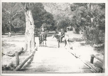
Photograph - B/W, C 1920s
The Stoney Creek dray bridge. Stoney Creek has been bridged a number of times on school road since the creek was re-routed in the early 1900s. A dray bridge was built C 1910 by local residents, which stood them in good stead for more than a decade. This bridge was replaced by a higher timber structure. Image two is a story from 1906 relating to Marshall White and his family trying to recross Delley's bridge after finding the Stoney Creek dray bridge washed away.Photo of two men on horseback on a wooden bridge with low log railing. A shelter can be seen in the background and there are thick trees surrounding the road.structures, bridges -
 Kiewa Valley Historical Society
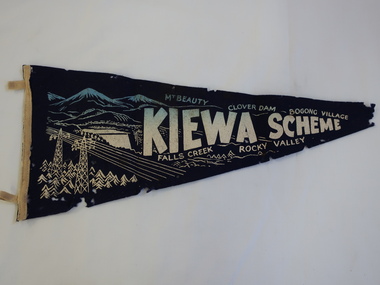
Pennant - Kiewa Scheme
Pennants are used to advertise events or places. This pennant includes all the main areas of construction done by the State Electricity Commission of Victoria during their construction of the Kiewa Hydro Electric Scheme. The pennant advertises the highlights in the construction of the Kiewa Hydro Electric Scheme.A small triangular navy blue with gold printing fabric with a strip of woollen bias binding on the left side with a tab at the top and bottom for attaching to a rod to enable the pennant to hang. The background of the printing is of mountains with water flowing out of a dam and in the front on the left power poles and power lines.In gold - large letters"Kiewa Scheme" decreasing in size. On the top also in gold "Mt Beauty" "Clover Dam" and "Bogong Village" and underneath "Falls Creek" Rocky Valley"kiewa scheme, pennant -
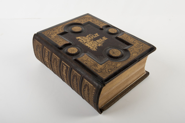 Uniting Church Archives - Synod of Victoria
Bible, Holy Bible
Heavily embossed and patterned in gold leaf bible with black and white plates and illustrations. Dedication page.On spine: "Holy Bible Brown's Notes" Dedication inside front cover: "This Bible was given by Mrs Ferguson to the Strath Creek Church when she left the district in 1901" -
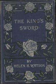 Nillumbik Historical Society Incorporated
Book - Hardcover book, Helen H Watson, The King's Sword
Blue cover with embossed roses in silver on front and blank back, 192 pagesfiction -
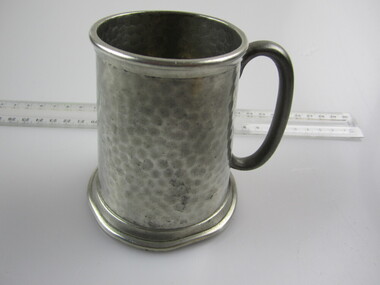 Ballarat RSL Sub-Branch Inc.
Tankard (Sm)
This object relates to SGT Francis John BALMAIN VX133588, 2/1 AUST FORESTRY COYSilver engraved - "HQ R.A.E. 2ND DIV."; Note from Sgt F J Balmain reads "A memento of my 21st Birthday Darwin 24.10.1943 at Coomalie Creek"second world war (ww2), 1939 - 1945, collectables, ballarat rsl, ballarat -
Queenscliffe Maritime Museum
Photograph - Landed Shark
Shark fishing was important to the Queenscliff Point Lonsdale fishing industry since early 1900s. It is still a popular activity in the area today.Fishing of all kind has been an important industry in the Queenscliff region. Although commercial fishing has greatly diminished, recreational fishing is still an important activity.Laminated photograph of a shark on the crane on Fishermans Pier circa 193820 Beach Street Queenscliffe. Debbie O'Hare? [illegible]. Back of Glenuse Reef in Point Lonsdale. Whole salmon for bait 5am. In creek on crane. 2,100Lbs, 8'6" Girthshark, shark fishing, queenscliff, fishing industry -
![Scene near Bright / [by] Nicholas Caire, circa 1876](/media/collectors/550653872162f11fb04854aa/items/578310d1d0cdd1176c462743/item-media/5783113fd0cdd1176c46de2e/item-fit-380x285.jpg) Kew Historical Society Inc
Kew Historical Society IncPhotograph, Anglo-Australasian Photographic Company, Scene near Bright, c. 1876
Nicholas Caire was born on Guernsey in the Channel Islands in 1837. He arrived in Adelaide with his parents in about 1860. In 1867, following photographic journeys in Gippsland, he opened a studio in Adelaide. From 1870 to 1876 he lived and worked in Talbot in Central Victoria. In 1876 he purchased T. F. Chuck's studios in the Royal Arcade Melbourne. In 1885, following the introduction of dry plate photography, he began a series of landscape series, which were commercially successful. As a photographer, he travelled extensively through Victoria, photographing places few of his contemporaries had previously seen. He died in 1918. Reference: Jack Cato, 'Caire, Nicholas John (1837–1918)', Australian Dictionary of Biography.An original, rare photograph from the series 'Views of Victoria: General Series' by the photographer, Nicholas Caire (1837-1918). The series of 60 photographs that comprise the series was issued c. 1876 and reinforced a neo-Romantic view of the Australian landscape to which a growing nationalist movement would respond. Nicholas Caire was active as a photographer in Australia from 1858 until his death in 1918. His vision of the Australian bush and pioneer life had a counterpart in the works of Henry Lawson and other nationalist poets, authors and painters.‘Scene near Bright’ : Views of Victoria (General Series) No.47 : Albumen silver photograph | Photo on card with Title and Description on reverse | Mounted 24 x 30 cm; Photo 12 x 17 cm.On Reverse: ‘The subject of this illustration is taken on the road to Grouber’s, near the township of Bright, in the Beechworth District. The scenery on the rivers and creeks which surround this township is of a very romantic and picturesque description.’nicholas caire (1837-1918), bright (vic), landscape photography - victoria -
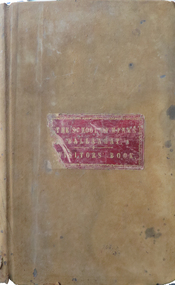 Federation University Historical Collection
Book, Ballarat School of Mines Visitors' Book, 1879-1890, 1879-1890
James Redmond Gilbert (sr) was born in 1837 at Hamilton, Ontario, Canada. He married Ellen Spouse. He , James Gilbert died on 26 July 1900 at Melbourne, and is buried at Boroondara Cemetery (Kew). J.R Gilbert lived at Running Creek (later Havilah) for some time, and during that time was employed in one of the bigger mines in the district. (Research by Ren at Havilah Research, 2019) Leatherbound ledger with hand written names, professions, residence and remarks relating to visitors to the Ballarat School of Mines. Sample Names: 1881 May 2 David Kerr Diamond Miner South Africa May 2 S. R. Dodds Diamond Miner South Africa May 3 Albert E. King Accountant Adelaide, South Australia "see signature 6 leaves back" May 6 William Morley Wesleyan Minister Auckland, New Zealand May 6 Rainsford Ravin Wellington, New Zealand May 7 Frank E. Lawrence, Lake River, Tasmania May 9 M. Richter Engineer Germany May 9 Dr Wilhelm Landall naturalist Berlin, Germany May 10 William Ralph Heaton Mercantile Birmingham May 11 Arthur I. Traill Grazier Llanpollen, New South Wales May 10 Marian Traill 1882 July 10 Arthur W.W. Brown London July 10 Benjamin Spargo Mining Mananger and owner Snowy Creek July 10 Thomas Cooke Miner Ballarat July 14 Robert H. Kenny July 14 Mr and Mrs Buston, [Indigo Planter?] Bengal, Indonesia July 14 Samuel H. Halker Ballarat July 14 Charles Phelan Talbot July 14 E. Walker Ballarat 1884 June 30 M.N. Cooper Dunedin, new Zealand June 30 Richard Hosking gardiner Gong Gong Well pleased with School June 30 Humphrey John Ballarat July 1 Cecily Gilbert Melbourne July 1 Florence Shrivall Melbourne July 1 [W.N. Marsh?] Colonial Secretary Hong Kong July 1 Louis Fause Engine Driver Dunolly July 1 John L. Bertram Blacksmith Melbourne July 1 Thomas Eardley Coachmaker London "Exceedingly obliged to Mr Oddie for a very pleasant instruction time spent in inspection of the various scientific appliances in the Ballarat School of Mines." (Donation 2/6) July 4 E. Goodwin [David?] Artist Spellbound July 4 W. Glumley Station Master Murtoa July July 4 James Thomas Miner Corrinondie, New Zealand "Very pleased with the School in all its branches. I hope to contribute to the specimen department. J.T." July 8 Robert Wall Engine Driver 1885 September 16 J.W. Springthorpe, M.D., Melbourne (very much pleased in every way) September 26 M. Oddie, Ballarat 1886 January 12 William Piekard, Leicester, England January 12 Robert Linford, Norwich, England January 12 H. Tipping, Draughtsman, Adelaide (Very instructive and should be taken advantage of by all who can) January 12 Fred H.K. Dreslecher, London (ditto) January 23 Walter Redgate, Manchester (ditto) April 7 Annie Bellingham, Richmond April 9 Fred Kruger, Landscape Photo, Geelong April 14 Mary Barry, Murtoa April 19 N.J. Tabuteau Accountant Napier, New Zealand April 19 George N. [Baroft?] Gentleman Cheshire, England April 21 Hon. George D'Almaine, Peer of England, London April 21 Lord Augustus Honour April 21 William Holt, South Melbourne April 21 H. Bartell, Gentleman, Smythes April 21 Fred Musgrove, Gentleman April 21 A. Chirnside, Squatter April 23 Alice Cravino, student, Buninyong April 24 East Melbourne Bicycle Club April 28 J. Kinnear, Kyneton April 28 J.P. Kinnear, Kyneton May 19 Bob Selby, Doctor, Ballarat May 19 J.W.M.. Quiggin, globe trotter, Picton (NS Wales) May 25 Arthur Night, Sutton Hotel, Ballarat (very fair) May 28 D. Kelly, attendant, China May 28 J. Kelly, schoolboy, China June 1 Joseph Jelbart, Blacksmith, Harrow September 9 David Ham, M.L.C. Ballarat ( A right to be pleased) September 9 J.J. Green, Merchant, Adelaide (Very much pleased with my visit to this intitiution it has my hearty sympathy and appreciation, Much pleased at what I have seen its value to the community) 9 December James H. Tappin, Agent, Ballarat (very pleased with instruction 1887 March 20 Thomas Bath Learmonth March 20 James R. Gilbert= Miner Running Creek March 20 C. Holtermann Out of business Adelaide 1890 21 May Mr and Mrs Fairchild, gentleman. Yarra house, Dalgety St, St Kildaballarat school of mines, visitors, j.w. springthorpe, chinese visitors, visitors' book, running creek, james redmond gilbert sr, havilah -
 Bayside Gallery - Bayside City Council Art & Heritage Collection
Flag, Evan Evans, City of Brighton flag
The coat of arms on this flag were granted by the British College of Arms in 1970 and represented Brighton City Council's "growing awareness of the importance of formality and correct symbolism in local government". It replaced the council's crest of a pier and yachting scene and was used as council's seal, emblem on its flag and letterhead. The new Coat of Arms, drawn up by the College of Arms in England, depicts the progression from a seaside gardening community to a modern residential city. The prominent forms are on the shield-like coat of arms include waves and a Lymphad (a ship, symbolic of the sea); a market gardener; an aboriginal man; two horns of plenty with abundant fruit and vegetables (the wealth and plenty) and Elster Creek (now Elster Canal). It is underscored by the motto "By their fruits, ye shall know them". Brighton was first incorporated as a borough on 18 January 1859, it became a town on 18 March 1887 and was proclaimed a city on 12 March 1919.Green flag with circular City of Brighton Coat of Arms in the centre. The central circle is white with a yellow edge, with a polychrome coat of arms featuring: the crest which is two cornucopia with fruits and vegetables, above sits a seagull. The mantle above the helmet is in green and gold. The shield is also green and gold with a lymphad (ship) and blue and white waves. The market gardener, holding a hoe, and Aboriginal figure, bearing a boomerang, support the shield and stand upon the compartment which is soil with a representation of Elster creek. A ribbon below contains the motto in blue 'FRUCTU NOSCITUR'.flag, brighton, city of brighton, coat of arms, college of arms, market gardener, aboriginal, elster creek, lymphad, fructu noscitur, armorial bearings, heraldry, cornucopia, by their fruits ye shall know them, motto -
 Eltham District Historical Society Inc
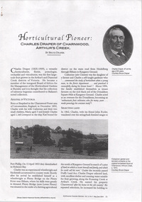
Document - Folder, Bruce G Draper, Draper, 2011
Folder on Draper family contents: 1. Magazine article: Horticultural Pioneer: Charles Draper of Charnwood, Arthur's Creek by Bruce Draper, Australian Garden History, Vol. 15 No. 5, May/June 2004, pp15-20draper family, charnwood, arthur's creek, charles draper, bruce draper -
 Bendigo Military Museum
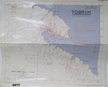
Map - MAP of TOBRUK HARBOUR, 48 Survey Coy S.A.E.C, C.1942
Item in the Doug Dean 2nd AIF collection, refer cat No 4575PMap, laminated, “MAP T/1 SECRET TOBRUK”, shows Tobruk area and harbour, shows creeks, gullies, there are 20 marked installations in red, a rectangular section has been hand drawn on marked “E” & “F”,.At bottom RH corner, “HQ, RAF, ME, A1, 16 JULY 1942”tobruk, maps, ww2 -
Glenelg Shire Council Cultural Collection
Photograph - Copy Of Photograph - First Jetty And Migration Depot, 1859
Vern Mc Callum CollectionDigital copy of a monochrome photo. Taken in Portland in 1859 looking south to Battry Point. Immigration depot on right. Wooden jetty with shed, centre of photo. Buildings on sand spit, mouth of wattle creek, back left. -
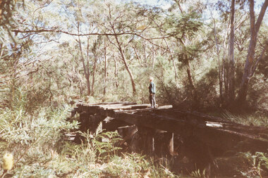
 Halls Gap & Grampians Historical Society
Photograph - Coloured, C 1980s (?)
Photo shows old wooden rail bridge curved up and over a creek. A man is standing on bridge looking down, a woman is kneeling behind man and is also looking down. Tree branches are leaning over bridge.'Old rail bridge"structures, bridges, trains -
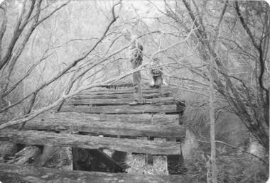
 Halls Gap & Grampians Historical Society
Photograph - Coloured, C 1980s
This is a photo of one of the trestle bridges on the Heatherlie Quarry train line. It is located near the current site of "the Pines" campground. The woman on the bridge is Janet Witham.Photo is of a derelict trestle bridge over a shallow creek, taken on an angle. There are many sleepers missing and the bridge is surrounded by thick bush and trees. There is bracken in the left foreground. A woman wearing a blue top and grey/brown slacks.structures, bridges, quarrying, heatherlie -
 Marysville & District Historical Society
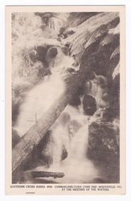
Postcard (item) - Black and white postcard, Rose Stereograph Company, Cumberland-Cora Lynn Trip, Marysville, Vic. At the Meeting of the Waters, 1913-1967
A postcard in a series produced by the Rose Stereograph Company in Victoria, Australia.A black and white photograph of the Cora-Lynn waterfalls at the Meeting of the Waters near the Cumberland Creek. These falls are located on the Marysville-Wood's Point Road. Cambarville is notable for its giant mountain ash (Eucalyptus regnans) trees within the Cumberland Memorial Scenic Reserve, and relics from former sawmills and gold mining. The Big Culvert is located nearby on the Marysville-Woods Point Road, which was historically part of the Yarra Track. Cambarville was established as a timber mill town in the 1940s. Timber mill owners A Cameron and FJ Barton named Cambarville. They established the mill to salvage timber from trees destroyed in the 1939 bushfires. Cambarville was impacted by the 2009 Black Saturday bushfires and any remaining structures were destroyed. This postcard was produced by the Rose Stereograph Company as a souvenir of Marysville.POST CARD. Correspondence/ Addresscora lynn falls, waterfalls, cumberland valley, cumberland creek, marysville, victoria, southern cross series, 4938, postcard, souvenir, meeting of the waters, marysville-wood's point road, cambarville, eucalyptus regnans, big culvert, cumberland memorial scenic reserve, a cameron, fj barton, 1939 bushfires, 2009 black saturday bushfires, rose stereograph company -
 Ringwood and District Historical Society
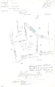
Document - Copy of Lands Department Field Notes - Ringwood, Victoria, Field Notes 76631 Surveyed in 1878
Foolscap size photocopy of survey map with handwritten notations. References include Canterbury Road, Bungalook Road, Dandenong Creek, Frank Miller, H.K. Kemps, Leech. Notations signed and dated January 1878 and May 1879. -
 Bendigo Historical Society Inc.
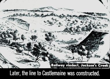
Slide - DIGGERS & MINING. THE GOLD ERA, c1850
Diggers & mining. The gold era. Later, the line to Castlemaine was constructed. Slide shows rail line going between to valleys. Railway viaduct, Jackson's Creek. Markings 44 994.031 GOL:5. Used as a teaching aid.hanimounteducation, tertiary, goldfields -
 Bendigo Historical Society Inc.
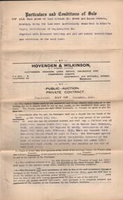
Document - H.A. & S.R. WILKINSON COLLECTION: CONDITION OF SALE
Condition of sale by private contract dated 14th. December, 1928 between G. J. Wilkinson and M. Berry for land at corner Creek and Haman Streets Bendigo together with 5-roomed dwelling for the price of 350 pounds.organization, business, h.a. & s.r wilkinson real estate -
 Bendigo Historical Society Inc.
Document - ENQUIRY: ROWE FAMILY
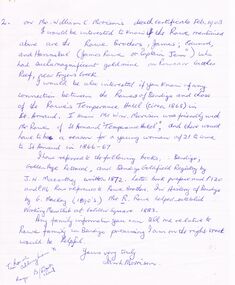
Enquiry re Rowe family - page 2 of an undated letter re Rowe brothers - James, Edward and Hannibal. Mention of Rowes Reef mine at Fryers Creek. Also, mention of Rowe's Temperance Hotel (St Arnaud).Ian L. Morrisonperson, family, rowe family, working mens club golden square, st arnaud temperance hotel -
Clunes Museum
Photograph - POSTCARDS
Photograph postcards, black and white images of Clunes and surrounds; .1 St. Paul's C of E Clunes .2 Methodist Church, Clunes .3 Tullarook Creek, Clunes .4 Monument at Clunes .5 Soldier's Memorialclunes history, methodist church -
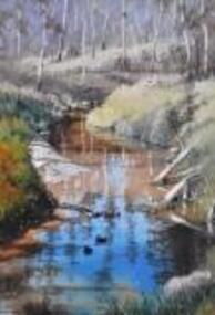 Nillumbik Shire Council
Painting: Walter MAGILTON, Walter Magilton, Sunlight and Shadows, Warrandyte, 2011
Walter Magilton's professional painting career is highlighted by numerous solo exhibitions, five of which have been in Great Britain. He has also won countless prizes, which include many 'Best in Show' awards. Walter is represented in a great number of private and corporate national and international collections, including ART Bank, in approximately twelve countries.This painting is a one of a series of approximately eight works of the river at Warrandyte and the local creeks, with particular emphasis on the reflections in the water and of the wattle growing along the banks. I was particularly inspired by Penleigh Boyde who did similar work while living in Warrandyte in the early 1920s.'Sunlight and Shadows, Warrandyte' is an oil on canvas painting depicting the Warrandyte landscape, featuring a winding creek with beautiful reflections cast upon it. The colour palate comprises muted green and earth tones, with a vivid aqua for reflective water.walter magilton, nillumbik, warrandyte