Showing 10536 items
matching lander
-
 Tatura Irrigation & Wartime Camps Museum
Photograph - copy, V. Russell Photographer, Thistle Conference Rochester 1907, 1907
Original photograph of 39 men from G. V. Region at Thistle Conference, Rochester, 30 May 1907. Men would have been Councillors. Thistles on the land were a great problem in the early 1900's. Unemployed were often given the job of digging them out. Original L0407.Sepia photograph of 39 men outside Council Chambers, Rochester, 1907.on back: Thistle Conference Rochester 30 May 1907thistle conference rochester -
 Whitehorse Historical Society Inc.
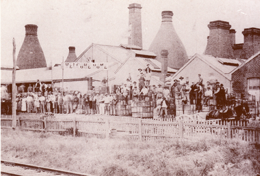
Photograph, Australian Tesselated Tile Co, c1920
The Australian Tesselated Tile Co. began in Mitcham, south of the Railway Station in 1886. It almost collapsed after the bursting of the Land Boom in 1890's, then recovered to become one of the world's greatest Tile Works. It made a greater range of tiles than any other known Tile Works, here or overseas.Black and white photo of Australian Tesselated Tile Co (then know as the Australian Brick and Tessellated Tile Company) with workers gathered to welcome home their Manager Mr.E.E Walker.australian tesselated tile co.pty ltd, australian brick and tesselated tile co, walker. edgar edwardes. -
 Melbourne Legacy
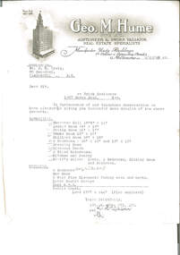
Letter, re Brick Residence 1267 Burke Road, Kew, 1942
Detailed measurements of the rooms, but the plan of the land noted as being enclosed is not included. The details had been requested in a previous telephone conversation between the parties, indicating early interest in purchasing the property which ultimately became Holmbush. Despite being from a real estate agent there is little in the way of a sales pitch.As well as indicating the extent of the rooms, it also notes that the property had a coke hot water system, which would have been typical of the 1940s, as would the elaborate letterhead.Typewritten undated letter on letterhead of Geo.M.Hume Pty Ltd., black on white, addressed to Mr. D.N. CraigSignature illegible.holmbush initial negotiations, properties, holmbush -
 Surrey Hills Historical Society Collection
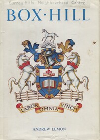
Book, Box Hill, 1978
This book looks at Box Hill as it grew from a rural backwater to a country town amid farms and orchards, then to an outer suburb, and then to an almost inner suburb. It covers the rural depression in the 1860s, the land boom of the 1880s and the collapse in the 1890s, the bitter days of two World Wars and the Depression, and the 'dry' suburb of Box Hill.Hardback book of 270 pages, indexed and footnoted, with some photos and plans; it is divided into chronological periods rather than themes."SURREY HILLS / NEIGHBOURHOOD CENTRE - HISTORY" on top of title page; "Surrey Hills Neighbourhood Centre" on top of front of jacket.box hill, dry area, temperance movement, mayors, councillors, agriculture, railways -
 Wooragee Landcare Group
Newsletter - Wooragee Landcare Group Bound newsletters Volume 2, pages 5 & 6, February 2000
February 2000 newsletter, second and third pages. Topics on these two pages include: Rabbit Control Committee meeting report for January 2000 Land management information Reedy Creek future health project Progress Association update Neighbourhood Watch update Map of rabbit spotlighting results (page 6)This is an important item for the WLG being one of two bound series of newsletters prepared for the group by Owen Gemmillwooragee landcare group, pest control, rabbits, reedy creek, community news, land management -
Wooragee Landcare Group
Newsletter - Wooragee Landcare Group Bound newsletters Volume 2, pages 5 & 6, February 2000
February 2000 newsletter, second and third pages. Topics on these two pages include: Rabbit Control Committee meeting report for January 2000 Land management information Reedy Creek future health project Progress Association update Neighbourhood Watch update Map of rabbit spotlighting results (page 6)This is an important item for the WLG being one of two bound series of newsletters prepared for the group by Owen Gemmillwooragee landcare group, pest control, rabbits, reedy creek, community news, land management -
 Wodonga & District Historical Society Inc
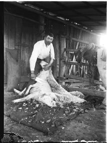
Negative - Haeusler Glass Negatives Collection - Harry Schuster blade shearing, c1910
The Wodonga Historical Society Haeusler Collection provides invaluable insight into life in late nineteenth and early twentieth century north east Victoria. The collection comprises manuscripts, personal artefacts used by the Haeusler family on their farm in Wodonga, and a set of glass negatives which offer a unique visual snapshot of the domestic and social lives of the Haeusler family and local Wodonga community. The Haeusler family migrated from Prussia (Germany) to South Australia in the 1840s and 1850s, before purchasing 100 acres of Crown Land made available under the Victorian Lands Act 1862 (also known as ‘Duffy’s Land Act’) in 1866 in what is now Wodonga West. The Haeusler family were one of several German families to migrate from South Australia to Wodonga in the 1860s. The Schuster family were also of German migrant background. Johannes Edward Schuster was born in Hoyles Plains, South Australia and with his wife Johanna and young family moved to Victoria circa 1882. He took up farming land in Wodonga West. The St John’s Lutheran Church Sunday school hall was erected from part of the proceeds of the sale of some 41 acres of land at Wodonga West, which had been bequeathed to the Wodonga congregation by the late Johannes Edward Schuster. This land was the original home site of the Schuster family on arrival from South Australia. Shearing - Although the first mechanised sheep shearing machine was created by James Higham, from Melbourne in 1868, the use of blade shears were more common well into the early 20th century. Pastoralists on smaller holdings continued to either shear their own sheep or employ blade shearers rather than outlay the cost of machines. In large sheds, professional shearers worked as they travelled the country. They would earn around 17 to 20 shillings per day in the early days of the wool industry. However mechanisation continued and by 1915 most sheep shearing sheds in Australia contained sheep shearing machines. The original machines were powered by steam and later combustion engines were used. This digital image was produced from one of the glass negatives that form part of the collection, probably taken by Louis Haeusler (b.1887) with the photographic equipment in the Wodonga Historical Society Haeusler Collection.This item is unique and has well documented provenance and a known owner. It forms part of a significant and representative historical collection which reflects the local history of Wodonga. It contributes to our understanding of domestic and family life in early twentieth century Wodonga, as well as providing interpretative capacity for themes including local history and social history.Digital image created from the Haeusler Glass negative collection. Harry Schuster shearing sheep using blade shears. wodonga pioneers, haeusler family, glass negatives, dry plate photography, blade shearing, schuster family -
 City of Moorabbin Historical Society (Operating the Box Cottage Museum)
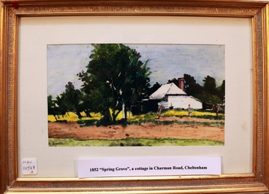
Painting, 'Spring Grove' 19thC house, c1979
In 1852 Stephen Charman purchased 160 acres bounded by Charman Rd and Balcombe Road in an area called Spring Grove , later Cheltenham. A spring ran through the land providing a good source of water. Stephen aged 21 years had arrived in Melbourne 1842 as one of Henry Dendy’s emigrants . His Ship passage was paid by the Colonial Land and Emigration Commission and in return he was required to work on the land of the Henry Dendy Special Survey Brighton 1841. However Henry Dendy could not provide enough work for all the emigrants that arrived and Stephen had to obtain other work. Then sadly his young wife Harriett and their infant died. 1850 Stephen married widow Mary Gettens, a Publican in Little Collins Street, with 5 children. Stephen & Mary built a wattle and daub hut and established a market garden producing marigolds for Martin & Pleasance Pharmacists, Melbourne. They had 7 more children and built a weatherboard cottage that was used for early Methodist Church services. Stephen donated 1 acre to the Methodist Church in 1855 for Chapel , School and Cemetery. This is the weatherboard cottage in the painting, The road between Cheltenham and Mentone bears their name. Mary died in 1870 and Stephen remarried 1878 and died in Gippsland 1906. Stephen and Mary Charman were pioneer settlers in the area of Spring Grove later known as Cheltenham . Charman Road Cheltenham commemorates their contribution to the development of the area A painting of 'Spring Grove' the home of Stephen Charman and Mary Charman formerly Gettens nee Rees, This cottage was the first house in Charman Road Cheltenham c1852signed L Schumerspring grove cottage 1852, schumer l, cheltenham, charman stephen, early settlers, jones a l , gettens mary, rees mary, charman mary, moorabbin, brighton, -
Federation University Historical Collection
Photograph - Black and White, Former Ballarat Library, c1960
First known development on this site was the establishment of the Government Camp from the early 1850s. It was established to accommodate officials, troopers and police who were needed to administer the goldfields. Some permanent buildings were constructed. Lack of materials and bad weather prolonged the building of more permanent buildings and most men were still living in tents. Area was known as Camp Reserve. In 1864 a subdivision map shows the reserve be used for Public Buildings. Library applied for land on corner of Sturt and Camp Streets in 1878. 1880s plans show section of the reserve be used for a Free Library and Reading Room. Lease was granted and the old mining boardroom was initially used. Land for additional building to house a Museum and Art Gallery sought and agreement reached in 1882-3. Compensation paid to owners and library granted the land. Plans for a new library building with tower and lantern roof abandoned due to lack of funds. It wasn't until 1895 that a solution to funding was found and the library was able to begin constructing the complex of buildings on the Free Library Reserve. A number of changes have occurred since 1910s - the Classical Revival facade replaced with an angled facade in a stripped Classical style with Art Deco features and high parapet. Building is now part of Federation UniversityPhotograph of former library. Shows a two-storey rendered brick building in a Classical style. Some Art Deco features. Central pair of double windows with single window either side. High parapet above.government camp, goldfields, camp reserve, free library, reading room, sturt street, camp street, museum, art gallery, troopers, police, barracks, camp street -
 Ararat Gallery TAMA
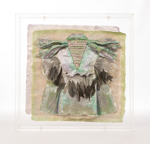
Mixed media, Inga Hunter, Nrat-tuan Boat Leader's Robe, 1986-1989
“Apart from the vast and sophisticated space fleet, the only forms of transport used by the Nrati-Tuan are boats and rafts. All the inhabitants are more at home in the water than on the land, but some transport is necessary, both for people and freight. Every family has at least two boats and an assortment of rafts. Many thousands live entirely on boats and never set foot on any form of land, even avoiding the floating islands. The Boatleader is really a leading transport official; the top office in a long chain of others, from the smallest boat-boy, to the night boatwatches who keep the waterways safe for traffic. There are several ranks of Boatleader, whose major function is to settle disputes about water rights and water paths. Courts of dispute sit regularly, handling the hundreds of problems which arise about water use, headed by a Boatleader of one rank or another. This robe is worn by the most senior of all. He is the representative of water rights at the great Court of the Imperium. To the Nrat-Tuan it is more a sacrifice than an honour to attend the Court, because none find it easy to stay on still, dry land for extended periods of time. Nrati-Tuan delegates to the Irusaqui Court are rewarded with high honours on their planet, to show public respect and gratitude for their endurance.” -Inga Hunter -
 Orbost & District Historical Society
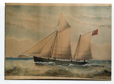
print
There were many vessels named "Endeavour". There are no details attached to this item. The Australian Civil Ensign, or Australian Red Ensign, is simply a red version of the Australian National flag. It is for use only at sea and officially never on land, but can be used by private citizens. It was in use in Australia and overseas during the first half of the 20th century.A coloured print of a painting of a ship (schooner?) in full sail. It is flying a red ensign.on back -' Endeavour"ship transport -
 Warrnambool and District Historical Society Inc.
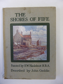
Book, The shores of Fife
This book belonged to Alice Mathieson. The Mathieson families were early settlers in the Woodford and Purnim areas as shopkeepers and farmers (1850s and 1860s). Peter Mathieson was a holder of land in the Nullawarre area in the 1880s. Alice Mathieson would probably be a member of this Nullawarre Mathieson family. No other information has been found about her. This book is of minor interest as an example of a 1920s attractively-illustrated book on an area in Scotland. It is also of interest as it belonged to a Nullawarre resident in the 1920s. This is a hard cover book of 68 pages. The cover has a grey background and a colour sketch of a house by the seashore on the front cover and black lettering on the front cover and on the spine. The book has twelve full page colour sketches scattered throughout the text. The cover and pages are somewhat stained and the spine is torn away at the bottom edge. The inscription is handwritten in pencil and black ink.‘Alice Mathieson Nullawarre 1927’ alice mathieson, nullawarre, history of warrnambool -
 Waverley RSL Sub Branch
Minefield Warning Flag
German Luftwaffe (Land Forces) minefield warning flag from WWII.originally intended to be gas markers, rather than mines, but as it turned out, the use changed .they were mounted on a red metal pole & there were 12 to a set in a leather pack. This Flag was presented to the Treasurer of Waverley RSL. It is a souvenir from Bardia in Libya The Battle of Bardia was fought over three days between 3 and 5 January 1941, as part of Operation Compass, the first military operation of the Western Desert Campaign of the Second World War. It was the first battle of the war in which an Australian Army formation took part, the first to be commanded by an Australian general and the first to be planned by an Australian staff. Major General Iven Mackay's 6th Division assaulted the strongly held Italian fortress of Bardia, Libya, assisted by air support and naval gunfire, and under the cover of an artillery barrage. The 16th Infantry Brigade attacked at dawn from the west, where the defences were known to be weak. Sappers blew gaps in the barbed wire with Bangalore torpedoes and filled in and broke down the sides of the anti-tank ditch with picks and shovels. This allowed the infantry and 23 Matilda II tanks of the 7th Royal Tank Regiment to enter the fortress and capture all their objectives, along with 8,000 prisoners. In the second phase of the operation, the 17th Infantry Brigade exploited the breach made in the perimeter, and pressed south as far as a secondary line of defences known as the Switch Line. On the second day, the 16th Infantry Brigade captured the township of Bardia, cutting the fortress in two. Thousands of prisoners were taken, and the Italian garrison now held out only in the northern and southernmost parts of the fortress. On the third day, the 19th Infantry Brigade advanced south from Bardia, supported by artillery and the Matilda tanks, now reduced in number to just six. Its advance allowed the 17th Infantry Brigade to make progress as well, and the two brigades reduced the southern sector of the fortress. Meanwhile, the Italian garrisons in the north surrendered to the 16th Infantry Brigade and the Support Group of the British 7th Armoured Division outside the fortress. In all, some 36,000 Italian prisoners were taken. The victory at Bardia enabled the Allied forces to continue the advance into Libya and ultimately capture almost all of Cyrenaica. In turn this would lead to German intervention in the fighting in North Africa, changing the nature of the war in that theatre. Bardia boosted the competence and reputation of the Australian Army. Perhaps most important of all, it raised confidence in the possibility of an ultimate Allied victory around the world, which would lead to the Lend-Lease Act being passed in the United States http://en.wikipedia.org/wiki/Battle_of_BardiaCloth Flag bearing a skull and cross Bones on a metal spike mounted on a square varnished wooden basebardia, land mine, marker flag, minefield, mustard gas -
 Greensborough Historical Society
Photograph - Digital Image, Marilyn Smith, Mernda Mechanics Institute 2018, 27/09/2018
In 2018 GHS members visited Turner's Bakery in Mernda for lunch and continued on to visit historic sites remaining in the Mernda area. This photograph shows the Mernda Mechanics Institute, established 1888. It was sited to the rear of the Bridge Inn Hotel on land donated by the hotel's owner. Today the Mechanic's institute is a small hall available to rent.Mernda is an area of rapid modern growth with a few remaining historic buildings dating from the 19th century.Digital copy of colour photographsmernda, mernda historic sites, mernda mechanics institute, mechanics institutes victoria, bridge inn hotel mernda -
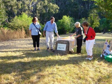 Greensborough Historical Society
Photograph - Digital image, Unveiling Happy Hollow plaque, 24/10/2006
Photograph of descendants of past owners of Happy Hollow unveiling the commemorative plaque. Includes descendants of Charles Partington, John McLaughlin and Robert Emmett Whatmough. The land was later owned by Mrs Betty Bell and was purchased by Parks Victoria in 1994 to form part of the Plenty Gorge Parklands. This plaque was laid by Plenty Historical Society. Digital copies of 3 colour photographs.happy hollow, plenty river, john mclaughlin, charles partington, robert emmett whatmough, parks victoria -
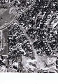 Greensborough Historical Society
Photograph - Digital image, Frank Solomon, Pig Farm, Weidlich Road area: aerial view, 02/08/2009
An aerial view of the pig farm in Weidlich Road Greensborough, owned by Werner Hanusch. The land was used as a pig farm and quarry from 1954 and has now been subdivided into the Evelyn Way estate. This project of fifty, one double storey, dwellings was commenced on 2/8/2009 and completed on 6/2/2011.An example of the changing land use in Greensborough, from farming to residential.Digital copy of aerial photographwerner otto fritz hanusch, pig farm st helena, weidlich road greensborough, one evelyn way greensborough -
 Halls Gap & Grampians Historical Society
Photograph - Coloured, Early 20th C
A tramline was built to bring logs down from a mill up on Stoney Creek. The tramline was made of timber and the trolleys of logs were pulled as afr as possible by horse and then a driver would ride the logs down to the flat land below pulling a brake when nearing the end. (Close to site of present Primary School).Photo is a copy of Anne Borella (nee Nicholson) depicting the haulage of timber along a tramline. Two horses are pulling a trolley while a driver stands on the load with the wheelbrake ready.transport, horse drawn, structures, tramway -
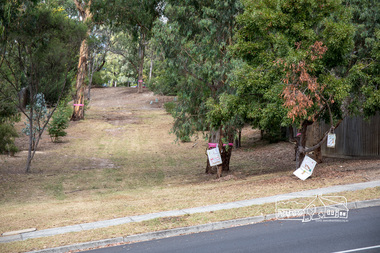 Eltham District Historical Society Inc
Photograph, Council owned Reserve running between Arthur Street and Ruskin Court, Eltham, 4 March 2018, 4/3/2018
Shows protest banners and ribbons placed by members of the community opposed to Nillumbik Council's proposal to sell this land along with 16 other reserves in the Shire. One of 17 reserves which 3,000 people rallied for at the former Shire office site on March 4th, 2018 then marched down Main Road to Luck Street.Born digital imagenillumbik shire council, parks, save community reserves, arthur street, ruskin court -
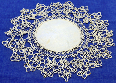 Orbost & District Historical Society
doily, late 19th -early 20th century
This doily was handmade by Penuel Cameron (nee Hossack). The Hossack family farmed land on the Marlo Road. Like the Camerons they were staunch Presbyterians. Robert Cameron was one of earliest settlers on Orbost flats and ran the paddlesteamer "Cheviot". He served many years on shire council and built the first Presbyterian. church in Orbost.This item is an example of a handcrafted item and reflects the needlework skills of women in the families of the early settlers.Hand tatted medium sized doily. Small round linen piece in centre and large tatted border.doily handcrafts needlework linen lace cameron-robert -
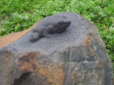 City of Ballarat
Artwork, other - Public Artwork, Joe Pratt et al, Hidden Waterway, 2016
To create 'Hidden waterway' (2016) Artist Forest Keegel held workshops with the people of Ballarat East who drew images in the park of threatened local fauna and waterbugs that once inhabited this land. Those images were then translated into carvings by sculptor Joe Pratt across 20 boulders creating a trail throughout the park. The artwork is of aesthetic and social significance to the people of Ballarat20 bluestone boulders with carvings across the surface creating a trail throughout the park forest keegel, joe pratt, ballarat east, pennyweight park -
Clunes Museum
Certificate - CERTIFICATE OF TITLE, 1884
CERTIFICATE OF TITLE. UNDER THE TRANSFER LAND STATUTE CATHERINE GRETTON OF CLUNES PROPRIETOR OF SAID CROWN ALLOTMENT WILLED TO JOHN LUCAS AND WILLIAM GRETTON DATED 28TH JUNE 1899. CATHERINE WOOLCOCK OF CLUNES INHERITED PROPERTY FROM JOHN LUCAS AND WILLIAM GRETTON JUNE 28TH 1899 AT 3 O'CLOCK IN THE AFTERNOON.PHOTOSTAT COPY, VICTORIAN GOVERNMENT CERTIFICATE OF TITLE. CATHERINE GRETTON OF CLUNES. DATED 14TH DAY OF MAY 1884.local history, document, certificates, document - title -
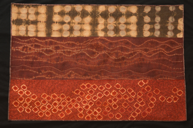 National Wool Museum
Quilt, Carolyn Sullivan, Out There, 2012
Entered for, and winner of, 2012 Expression: The Wool Quilt Prize. Artists statement: "Out there" refers to the wide view of the undulating land extending from our home acreage towards the escarpment and the coast. There are also the millions of small organisms that live out there. As well, out there is the vast Australian landscape which I find thrilling"Wool quilt in landscape orientation with three distinct design patterns, primarily orange/brown/red in colour. Top panel is a light brown background with paler circles inset. Middle panel is an ochre colour with horizontal uneven lines. Bottom panel is an orange colour with pale bordered square shapes. Artists panel on back bottom right corner. -
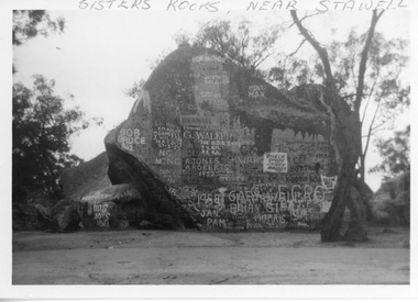 Stawell Historical Society Inc
Photograph, Sister Rocks 1962
Sisters Rocks 1962 By Marion Mitchell-Robinson. The photo shows the graffiti on the north side of the rock. There is a dead tree to the right of the photo. This photo is of a well known land mark along the Western Highway. They take their name from 3 sisters named Levy, who camped there with their parents during the early days of Stawell.Black & White photo of Sister Rocks. "Sister's Rocks, Near Stawell" written on the front in biro. Inscribed on the back "Sisters Rocks Stawell Vic. May-June 1962 Taken c1962 by Marion Mitchell-Robinson".tourism -
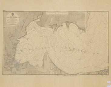 Queenscliffe Maritime Museum
Map - Chart of Geelong Harbour, Geelong Harbour
When Hamilton Hume and William Hovell arrived at the bay in 1824 they met with the local Wautharong people who referred to the bay as "Jillong" and the surround land "Corayo", but by the time the area was surveyed in the late 1830s the Aboriginal names had been swapped. The names "Corayo" and "Jillong" had since been Anglicised to "Corio" and "Geelong".Corio Bay is an important harbour and leisure location in the West and continues to attract development such as the new Tasmania Ferry Terminal.An Admiralty Chart of Geelong Harbour revised in 1954Geelong Harbour Map Ref: 2731geelong, corio, admiralty charts -
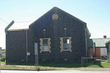
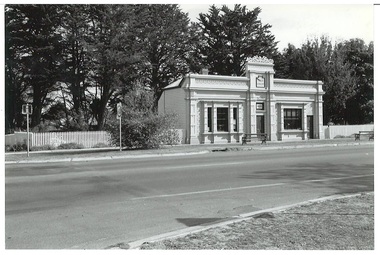 Buninyong & District Historical Society
Photograph - Black and white photograph, Former Free Library Warrenheip Street Buninyong, 9 April 1994
Built in 1861 on land made available by Mr. Robert Allen. Grant received through municipal council and State Government. Building functioned as a library until 1926. Taken over by Buninyong Cemetery Trust and eventually fell into serious disrepair. Restored in the 1980s after great community effort, dedication and financial contributions.An important early building in the township noted for its unusual and individual classical facade of Oregon pine. Placed on Historical Buildings Register.Black and white photograph of Former Free Library built in1861. Warrenheip streetscape of former free library, currently Buninyong Information Centre, Eastern facade fully visible and Southern weatherboard side. Mature pine trees visible to the side and rear of building. Reading room on left of entrance door and former shop and residence on right.free library, information centre, mr. robert allen, buninyong cemetery trust, mechanics institutes -
 Kew Historical Society Inc
Plan - Subdivision Plan, J R Mathers & McMillan, Heart of Richmond Estate : Richmond, 1928
"In 1928 the land on the east side of Johnson Street was subdivided in 60 lots for the ‘Heart of Richmond Estate’. The houses in the subdivision, along the east side of Johnson Street, and in the newly created Hollick, Cole and Kennedy streets were constructed from 1928 to 1937." (Source: City of Yarra Heritage Gaps Review One 2013)Portion of subdivision plan pasted on to cardboard. Area includes Johnson Street, Victoria Street, Kennedy Street, Cole Street, Hollick Street, Bennett StreetTitle Certificate Vol.2381, Folio 476130 Phillips, Fox & Masel, 440 Little Collins Street, Melbourne (Local estate agent: Jas. R. Mathers & McMIllan, 136 Cotham Road, Kew)subdivision plans - richmond (vic.), heart of richmond estate -
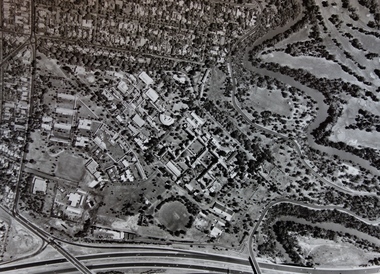 Kew Historical Society Inc
Photograph - Aerial Photograph, Aerial Photograph of Willsmere, circa 1980, c. 1980
This aerial photograph shows the Kew Cottages, and doctors/clergy residences on the north side of Wills Street, before the State Government sold the land for residential development. The doctors residences in Wills street were made of 'Glen Iris' Olympic Bricks. According to neighbours of the time most of the buildings were demolished overnight in the 1980s.Aerial photograph of Willsmere and the Kew Cottages bounded by the Boulevard, the Chandler Highway, Princess Street and Fellows Street. The roundabout at the intersection of Princess Street, Wills Street, and Eglinton Street is at the top left. The Eastern Freeway is at the lower edge of the photograph.kew cottages, eastern freeway, willsmere, yarra river, aerial photographs -- kew (vic), kew boulevard, willsmere mental hospital, kew mental hospital, kew childrens cottages -
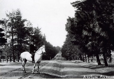 Sunbury Family History and Heritage Society Inc.
Photograph, c1900s
The man on the horse was photographed close to the main entrance of The Avenue which was the main approach to the former Sunbury Asylum. In later years the conifer trees were replaced with oak trees and today The Avenue is still the main road leading into Jacksons Hill, the housing estate that has been built on the former Sunbury Asylum land.The housing development on the former Sunbury Asylum site began in the 1980s. A black and white photograph of a man astride a white horse standing on an unmade road with an avenue of tall trees growing on either side of the formed road. A building is just visible in the distance.the avenue, sunbury as, jacksons hill -
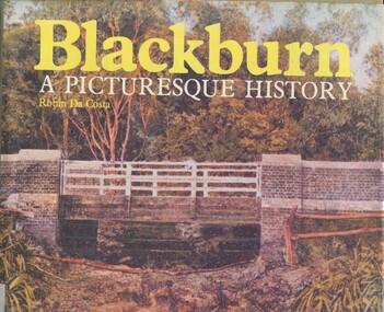 Surrey Hills Historical Society Collection
Book, Blackburn: A Picturesque History, 1978
This book focuses on the area's history and traces the development through settlement, adaptation and consolidation to the present. It discusses the history of early families, the railway, land boomers, churches and school. Robin da Costa, later Mrs Robin da Costa- Adams, came to live in Balwyn Road, Canterbury and joined the Canterbury History Group.Hardback book of 144 pages, indexed with multiple black and white photos.In Jocelyn Hall's writing: "Donated to Surrey Hills Neighbourhood Centre".(mr) james blackburn, meader's travellers' rest hotel, blackburn hotel, blackburn post office, blackburn railway station, blackburn pioneers, blackburn company, (mr) george augustus goodwin, (mr) thomas r b morton, blackburn brick works, st john's anglican church, blackburn methodist church, blackburn church of christ, blackburn presbyterian church, st thomas the apostle peace memorial church, seagoe common school, the courier blackburn, blackburn library, blackburn primary school, blackburn open-air school, blackburn creek hotel, blackburn college, blackburn kindergarten, newark grammar, blackburn hall, morton park, blackburn lake sanctuary, backhouse's dairy, blackburn lake, wandinong sanctuary, barelli bakehouse, blackburn cool store, blue moon fruit co-operative ltd, 1st blackburn scouts troop, blackburn and district tree preservation society, hotels, (ms) robin da costa -
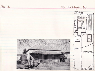 The Beechworth Burke Museum Research Collection
Card (Series) - Index Card, George Tibbits, 29 Bridge Street, Beechworth, 1976
George Tibbits, University of Melbourne. Faculty of Architecture, Building and Town & Regional PlanningIndex system that support the research for Beechworth : historical reconstruction / [by] George Tibbits ... [et al]Arranged by street names of BeechworthEach index card includes: street name and number of property, image of property, allotment and section number, property owners and dates of ownership, description of the property according to rate records, property floor plan with dimensions.beechworth, george tibbitsbeechworth, george tibbits