Showing 10390 items
matching plan
-
 Bendigo Historical Society Inc.
Map - CAMPBELL COLLECTION: BENDIGO AND DISTRICT MAPS, 23-4-29
Map. Whirrakee, Parish of Whirrakee, Total area 4419 acres, scale 20 chains to 1 inch. Unused water race in centre of map. Eucalypt Oil Distillery, bottom of map. Prepared in W.P.B. from Assessor's Plan and Parish Plan. G.W.Latimer 23-4-29. (number 385 in map cupboard 1)G.W.Latimermap, bendigo, agricultural lands -
 Eltham District Historical Society Inc
Book, Yarra Valley Metropolitan Park - Base Data and Analysis - Draft Report - Vol. III -Appendix 1997, 1977
Data collection and analysis, concept and policy planning, development plan for proposed Yarra Valley Metropolitan Park30 cm -
Bendigo Historical Society Inc.
Plan - MARKS COLLECTION: DRAWING OF ENTRANCE HALL FORTUNA VILLA
Laminated drawing of entrance hall to Fortuna Villa. Drawing is hand coloured and depicts stone building, entrance steps leading to double glass doors with side lights beside and above doors. Turret on top of building. On bottom of drawing is written 'Elevation' on top of plan Proposed Entrance Hall Fortuna Villa for G. Lansell Esq. Signed by W. Beebe, Architect.bendigo, buildings, fortuna villa -
 University of Melbourne, Burnley Campus Archives
Plan, Burnley Gardens. City of Richmond. Parish of Jika Jika - County of Bourke, 1927
Part-coloured plan showing drainage, sewerage drains, taps and waterstops. Area bounded by Swan St. To N, Yarra River on E and Richmond Park on SW side. Contour lines of orchard depicted, laying pens and yards. Coloured area depicts pavilion with surrounding garden and paths layout pencilled in. Photo-Lithograph by Dept. of Lands & Survey, Melbourne by W. Butsonsewerage, drainage, lithograph, pavilion -
University of Melbourne, Burnley Campus Archives
Plan, Orchard Plans, 1981
Plans and lists with row numbers and names. (1) Almonds, quinces, figs, peaches, dated 20.02/81. (2) Crabapples, nectarines, peaches, flowering cherries, feijoas, currants and deciduous trees. Bud stock area - Crops (3) Citrus, plums, apricots, apples, pears, almonds, peaches, figs, quinces, medlars. (4) As for (3) but with amendments. (5) Pear Block.fruits, orchards -
University of Melbourne, Burnley Campus Archives
Plan, The Museum of Modern Art at Heide, 1995
(1) Photocopy of Herb and Plant Location Map, Heide Kitchen Garden, plants numbered, no legend. (2) 1 tracing paper, 1 paper and 1 paper reduced size, Sketch Plan. Scale 1:1000. Drawn by JK 06.06.1995. (3) Photocopy of Heide Park and Art Gallery Grounds and Planting. Numbered Plant List, 1 Trees, 2 Shrubs.heide, museum of modern art, gardens -
 Warrnambool and District Historical Society Inc.
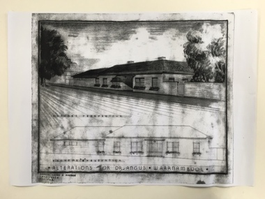
Document, Dr Angus residence plans, 1939
These are plans for alterations to the residence and surgery of Dr Angus in Koroit Street, Warrnambool (Birchwood). Dr William Roy Angus (1901-1970), after several years practising as a doctor in South Australia and northern Victoria, came to Warrnambool in 1939, purchasing the practice of Dr John Hunter Henderson (Birchwood). Dr Angus was a dominant figure in medical and community circles in Warrnambool for 30 years, becoming an important ophthalmologist in his later years. Birchwood, with its beautiful gardens, lawns and tennis court was suitable for entertaining and many distinguished people, including Vice-Regal personnel and representatives of the Red Cross stayed at the house. It was also a meeting place for representatives of the many organizations with which Dr Angus was associated (over 20 groups including the Good Neighbour Council, the Boys’ Club, the Food For Britain appeal, the Historical Society, Rostrum and the National Fitness Council). Birchwood or earlier buildings on the site was used as a residence/surgery by many doctors in Warrnambool, going back to the 1860s and Dr Angus and his family lived there from 1939 to 1967. In 1998 Birchwood was demolished and a new Warrnambool Police Station was built on the site. These plans are of interest as they show the 1939 alterations to the building known as Birchwood in Koroit Street Warrnambool. We have a good floor plan and a drawing of the front of the building so we know what it looked like in the late 1930s. Both Birchwood and Dr Angus are important in Warrnambool’s history. These are four sheets showing alterations for the residence of Dr Angus (Birchwood) in Koroit Street Warrnambool. One sheet shows the front of the house in colour drawn in ink and pencil and paint and there is a copy of this in black and white. The other drawing is of the plans for the house drawn in pencil and ink and with some red and blue colouring. There is another exact copy of this sheet. dr william roy angus, birchwood, history of warrnambool -
Glen Eira Historical Society
Plan - Brady Road, 10, Bentleigh East
A two page letter, dated 20/03/1973, from J M Smith and Emmerton Solicitors on behalf of Mrs J V Maxted to S P Simmons Estate Agent, requesting a sworn valuation of property at 10 Brady Road, Bentleigh East. The file also includes a photocopy of the certificate of title of the property, dated 28/02/1973. The certificate of title includes a plan (57mm x 65mm) of the property. The file also includes a two page letter, dated 30/03/1973, from S P Simmons responding to the request for valuation. Also included is a copy of these two pages. The file also includes one page of handwritten working notes for the property valuation including measurements and sales history of the property. The file also includes a hand drawn plan (114mm x 163mm) of the property with measurements.maxed j v, bentleigh east, brady road, wingate street -
 Ringwood and District Historical Society
Map, Proposed Subdivision - Hilltop Estate, Heathmont, Victoria - circa 1925
Plan of Part of Crown Allotments 16 & 18, Parish of Ringwood, County of Mornington. Subdivision includes Site for Heathmont Station, Heathmont Road, George Street, Lilian Street, Edith Street, Edna Street, Great Ryrie Street. Inset locality plan also shows nearby Electric Railway Estate and Heathmont Station Estate. L.H. Webber, Licensed Surveyor, 440 Little Collins Street, Melbourne. -
Bendigo Historical Society Inc.
Map - CAMPBELL COLLECTION: BENDIGO AND DISTRICT MAPS
Map. Ascot, Parishes of Huntly, Sandhurst and Wellsford. Scale 20 chains to 1 inch. Total area 2818 acres. To Bendigo 4 1/2 miles, to Epsom 3/4 mile, Huntly 3/4 mile. Prepared in W.P.B. from Assessment Plans and Parish Plans. (number 380 in map cupboard 1)map, bendigo, agricultural lands -
 Bendigo Historical Society Inc.
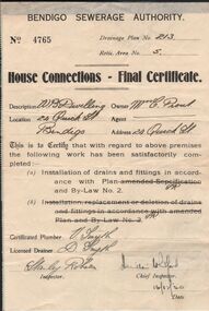
Document - L. PROUT COLLECTION: BENDIGO SEWERAGE AUTHORITY
Bendigo Sewerage Authority. Receipt No. 4765 - Drainage plan No. 213, retic. Area No. 5. house Connections Final Certificate. Location 24 Quick street, Bendigo - Owner Miss l. Prout. This is to certify that with regard to the above premises the following work has been satisfactorily completed: installation of drains and fittings in accordance with plan and by-law no.2organization, public utility, water -
 Bendigo Historical Society Inc.
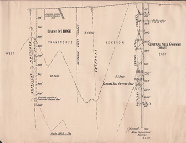
Document - MCCOLL, RANKIN AND STANISTREET COLLECTION: NAPOLEON REEF GOLD MINING CO. N.L, 1940
Document: 4 copies of plan of Transverse Section of Napoleon Anticline Lease no 10970, plan shows proposed shaft location and depth (1000 ft), for Napoleon Reef Gold Mining Co, also location and depth of adjacent Central Nell Gwynne Shaft scale 100ft = 1 inch, Prepared by J.J. Caldwell Mines Dept Bendigo.organization, business, industrial - mining, mccoll rankin & stanistreet, mining, gold mining, napoleon reef -
Whitehorse Historical Society Inc.
Article, Vermont South's salute, 1976
A 'City of Nunawading week' will be staged at Vermont South Shopping Centre. The week's activities will illustrate council sponsored activities.A 'City of Nunawading week' will be staged at Vermont South Shopping Centre. The week's activities will illustrate council sponsored activities. The shopping centre adjoins a large area of council owned land where a big new community centre is planned. the new primary school to be built in Livingstone Road and ready for occupation in 1978 will be planned to fit in with the development.A 'City of Nunawading week' will be staged at Vermont South Shopping Centre. The week's activities will illustrate council sponsored activities. shops, city of nunawading, vermont south shopping centre, livingstone primary school vermont south -
Whitehorse Historical Society Inc.
Certificate - Land Title, McCracken Orchards, 2000
Collection of Certificates of Title and lodged plans covering the land used as an orchard by the McCracken Family 1898 - 1962, comprising Cert. of Title vol 2699, Fol 660; Crown Portion 96, 1864 (part), Crown Portion 96, 1996; lodged plans 3681, 19126, 22255, 22256, 33386, with brief history prepared by P. Simmenauer.mccracken, john, mccracken, george, blackburn south, orchard grove, blackburn south, mccracken avenue, blackburn south, stewart avenue, blackburn south, lawrence street, blackburn south, wilton, edward, canterbury road, blackburn south, barns street, blackburn south, ralph street, blackburn south, horkings street, blackburn south, st ninians uniting church, blackburn south -
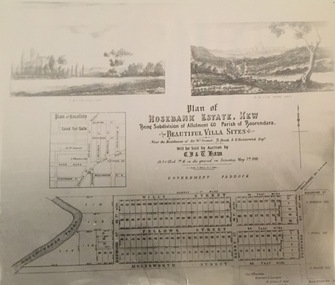 Kew Historical Society Inc
Print - Subdivision Plan, Rosebank Estate, Kew, Nineteenth Century
This work forms part of the collection assembled by the historian Dorothy Rogers, that was donated to the Kew Historical Society by her son John Rogers in 2015. The manuscripts, photographs, maps, and documents were sourced by her from both family and local collections or produced as references for her print publications. Many were directly used by Rogers in writing ‘Lovely Old Homes of Kew’ (1961) and 'A History of Kew' (1973), or the numerous articles on local history that she produced for suburban newspapers. Most of the photographs in the collection include detailed annotations in her hand. The Rogers Collection provides a comprehensive insight into the working habits of a historian in the 1960s and 1970s. Together it forms the largest privately-donated collection within the archives of the Kew Historical Society.A photographic reproduction of a plan in the Vale Collection of the State Library of Victoria. The plan shows the Rosebank Estate in Kew which was offered for sale in 1881. The subdivision was located in Studley Park and included lots in Redmond Street; Fellows Street; Wills Street; Molesworth Street; Barry Street and Princess Street. The surveyor of the subdivision was the local architect George Wharton.rosebank estate (kew), subdivisions -- studley park -- kew (vic.), thomas wills, wills family -
University of Melbourne, Burnley Campus Archives
Map, Melbourne Metropolitan Planning Scheme, c. 1978
Maps showing Zones and Reservations in the Merri Creek area of Melbourne, prepared by the Drafting Department, Planning Branch, MMBW. (1) Map No 36, coloured. (2) Map No 37, coloured. (3) Map No 38, not coloured. (4) Map No 46. Scale 1:9600. May have been used in planning the Native Garden Woodland Area. merri creek, melbourne and metropolitan board of works, melbourne metropolitan area -
University of Melbourne, Burnley Campus Archives
Plan, Emerald Environmental Horticulture Annexe VCAH Burnley, 1992-1996
In 2012 was owned by John Rayner who purchased site from The University of Melbourne in c2006.(1) Tracing paper Sketch. Scale 1:500 dated 26.7.96 drawn by JK. (2) Tracing paper and paper copies, "Proposed Location of Toilet Facility and Septic System." Scale 1:500. (3) Tracing paper copy,"Revegetation Program Works 1993/94." Scale 1:500. (4) Coloured laminated and tracing paper copies, "Proposed Concept Plan for Development." (5) Tracing paper and paper copies of labelled sketch. Scale 1:500. (6) Proposed Development 1994-95 - List of Proposed New Works. (7) Tracing paper and paper copies, Exisiting Ornamental Plants, Drawing No E1 drawn by J.J.W. 1.8.92. Scale 1:100. (8) Proposed Amenities Block at Lot Charman Ave, Emerald 3782 by Belgraphic. Drawn by Rosemarie, Plan No 93 003 tp March 1993. Scale 1:50. emerald, vcah, john rayner -
Stawell Historical Society Inc
Map - Drawings, Wendy Jacobs, Western Highway, 2014
WD 1/13 - Site Plan WD 2/13 - Existing Conditions & Demolition Plan WD 3/13 - Floor Plan WD 4/13 - Elevations WD 5/13 - Sections AA & BB WD 6/13 - Sections CC WD 7/13 - Sections DD, EE & FF WD 9/13 - Roof Plan WD 10 /13 Reflected Ceiling Plan WD 12/13 - Toilet & Meeting Cup'd Details WD 13/13 - DetailsEleven (11) A1 Printed MapsWendy Jacobs Architect & Heritage Consultant Nov 2014 -
 Orbost & District Historical Society
map, 1985
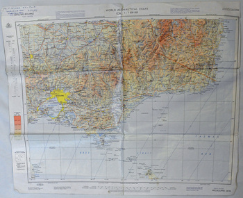
An aeronautical chart is a map designed to assist in navigation of aircraft. Using these charts and other tools, pilots are able to determine their position, safe altitude, best route to a destination, navigation aids along the way, alternative landing areas in case of an in-flight emergency, and other useful information such as radio frequencies and airspace boundaries. World aeronautical charts have a scale of 1:1,000,000 and cover relatively large areas. Orbost Aero Club began in 1969 with Basil Dowie as Chair, David Nixon as Secretary/Treasurer. The group went into recess from 1977-1991 closing in 1997. The mid 1960s were boom years in flying training in Australia and the number of Aero Clubs grew rapidly. The Club played a significant role in the establishment of the small airport at Marlo and in the ongoing operation and development of the airport over the years particularly for patient transfer by aerial ambulance. The Orbost Aero Club Club played a significant role in the establishment of the small airport at Marlo and in the ongoing operation and development of the airport over the years.A laminated map of eastern Victoria. A World Aeronautical Chart. It shows elevations, longitude etc and is designed for pre-flight planning as well as pilotage. Top left hand corner - D.F.N.Nixon VH-FWD 12 Kristine Ct Cheletenham 27/7/87orbost-aero-club aeronautical-map -
 Ringwood and District Historical Society
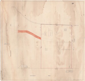
Map - Ringwood Animal Welfare Clinic, 1958 Land Survey Drawing, Ringwood, Victoria
Plan of driveway and property east of Heatherdale Road and Canterbury Road corner, with details of house, shed, bungalow, dog pen, kennels and enclosures.Survey by H.L.M. 31-7-58. Scale 20'=1" -
 Phillip Island and District Historical Society Inc.
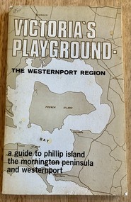
Book, Victoria's Playground The Westernport Region. A guide to Phillip Island, the Mornington Peninsula and Westernport, 1971
Description of Tourist Resorts on Mornington Peninsula and Westernport BayHistoricalBook - soft cover - 117 pages, First edition published 1971 by The Advisory Committee on Recreation and Tourism to The Westernport Regional Planning Authoritymornington peninsula, westernport bay, phillip island -
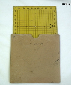 Bendigo Military Museum
Equipment - PROTRACTOR, SQUARE, C.1939 -45
Belonged to Thomas Henry ISER No V24933 and VX102660 2nd AIF. Refer Cat No 383.2 for his service history..1) 360 deg Protractor labelled as "Direction finder" Used for map navigation planning,yellow plastic. .2) Cardboard sleeve for .1).marked "T. ISER"navigation, protractor, military, equipment -
4th/19th Prince of Wales's Light Horse Regiment Unit History Room
Booklet, Manual of Land Warfare Part 2 Infantry Training Vol 5 Pam No 2 Mortar Tactical Employment and Fire Control 1980, 1980
A soft covered booklet providing mortar officers and NCO's with the principles of employment, deployment and fire planning required for tactical deployment of the mortar platoonDSN 7610-66-106-0083mortar operations -
 Victoria Police Museum
Police Stations (Armadale)
Armadale is an inner suburb of Melbourne, Victoria, Australia, 7 km south-east of Melbourne's Central Business District, located within the City of Stonnington local government area. Armadale Police Station opened, in Melbourne Police District, on 11 May 1885. Its original location is unknown, but in 1890 it is listed in the Sands & McDougall directory as at 295 Hight Street. From 1985-1920 it was located at 20/22 Auburn Grove, 1925-1930 at 769 High Street and 1935-1946 at 3 Cheel Street. The station closed on 28 January 1946. The sub-division east of Orrong Rd was incorporated into Malvern Sub-district and west of Orrong Road into Prahran Sub-district. In a special 1930 issue of the Victoria Police Gazette the Armadale Police Station was described as a seven-roomed brick dwelling with a tiled roof on land measuring 127' x 104' x 98'. There was also a bathroom and W.C., a wash-house, office, and a lock-up (one cell). This is probably a description of the Cheel Street police station. It was staffed by one senior constable and three foot constables.12 photographs comprising 8 coloured images and 4 black and white images 1 sketch plan of Old Armadale Police Stationpolice stations; armadale police station -
Ringwood and District Historical Society
Envelope, Jeanette Maynard, Packet: Jeanette Maynard, Masters Prelim in Environmental Studies - Ringwood History and Planning, 1991, 1991
Jeanette Maynard, Masters Prelim in Environmental Studies, Faculty of Architecture and Planning Melbourne 1991; Letter from Jeanette Maynard to Mrs Pullin -
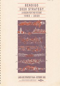 Bendigo Historical Society Inc.
Document - VERN ROBSON COLLECTION: BENDIGO 2020 STRATEGY, October, 1993
Document, 92 pages bound, 'Bendigo 2020 Strategy, a vision for the future, 1993 - 2020' Land use strategy plan - October 1993.bendigo, council, city of greater bendigo -
Bendigo Historical Society Inc.
Book - URBAN RENEWAL PROPOSAL BOROUGH OF EAGLEHAWK
16 page spiral bound booklet ' Summary of the Urban Renewal Proposal of the Borough of Eaglehawk, December 1976' Includes proposed plan maps.Urban Renewal Authority, Melbourne -
Port Melbourne Historical & Preservation Society
Map - MMBW, 1895
MMBW 1895 Plan No's. 344 to 349 Segment: Ingles to Bridge, Nott to Esplanade East (on south) Scale 40ft=1" (large)311/H 22melbourne and metropolitan board of works, port melbourne town hall, built environment, business and traders - hotels -
 Port Melbourne Historical & Preservation Society
Map - Plan of Melbourne, 1855
Framed copy of 1855 "Plan of Melbourne and its suburbs". Black frame. Some writing can be seen on left hand side of print.built environment, melbourne and metropolitan board of works -
Port Melbourne Historical & Preservation Society
Map - Road plans for Fishermens Bend, R S Atkinson, 30 Apr 1946
CRB Map outlining road plans for Fishermens Bend and including the site of the Commonwealth Aircraft Corporation, Aerodrome, General Holdens and C.S.R.I., 1946transport - aviation and aerodrome, industry - manufacturing, fishermans bend