Showing 4324 items
matching form photograph
-
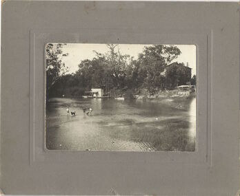
![Studley Park [Toll] Bridge, Kew](/media/collectors/550653872162f11fb04854aa/items/579ebf04d0cdd117c4c0815f/item-media/579ebf3ad0cdd117c4c0953e/item-fit-380x285.jpg) Kew Historical Society Inc
Kew Historical Society IncPhotograph, Studley Park [Toll] Bridge, Kew, 1870s
‘Studley Park Bridge’ or ‘penny bridge’ linked Church Street in Abbotsford and what is now Yarra Bend Park. The privately constructed bridge opened in 1857, gaining its popular name from the toll charged at the Abbotsford end. The engineer of the 485ft wide bridge was Mr. Austin and the builder was ‘Mr Grant, who threw the bridge over the Niagara’. Following the opening of Johnston Street Bridge, declining tolls led to the Bridge falling into disrepair. Badly damaged by the flood of 1891, the Bridge was compulsorily acquired by the Government in 1899, and later dismantled and sold for firewood.This work forms part of the collection assembled by the historian Dorothy Rogers, that was donated to the Kew Historical Society by her son John Rogers in 2015. The manuscripts, photographs, maps, and documents were sourced by her from both family and local collections or produced as references for her print publications. Many were directly used by Rogers in writing ‘Lovely Old Homes of Kew’ (1961) and 'A History of Kew' (1973), or the numerous articles on local history that she produced for suburban newspapers. Most of the photographs in the collection include detailed annotations in her hand. The Rogers Collection provides a comprehensive insight into the working habits of a historian in the 1960s and 1970s. Together it forms the largest privately-donated collection within the archives of the Kew Historical Society.A print, taken in the 1960s by Dorothy Rogers, from an original albumen silver photograph now in the collection of the Kew Historical Society. The photograph shows the toll bridge (also known as the Penny Bridge) from the northern end."P[enny] Toll Bridge - built 1857. from old photo"studley park bridge, penny bridge, bridge, timber bridge, toll bridge -
 Kew Historical Society Inc
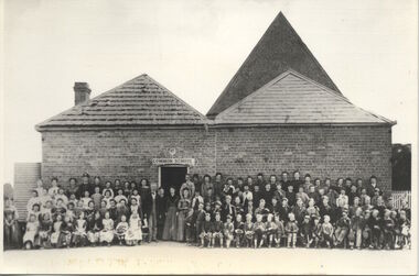
Photograph, Kew Common School, c. 1863
The Kew Common School, which had erected a new building in Peel Street only two years before the passing of the Education Act 1872, was retained and re-badged asState School No 1075, with numerous additions being made over the next few decades. This work forms part of the collection assembled by the historian Dorothy Rogers, that was donated to the Kew Historical Society by her son John Rogers in 2015. The manuscripts, photographs, maps, and documents were sourced by her from both family and local collections or produced as references for her print publications. Many were directly used by Rogers in writing ‘Lovely Old Homes of Kew’ (1961) and 'A History of Kew' (1973), or the numerous articles on local history that she produced for suburban newspapers. Most of the photographs in the collection include detailed annotations in her hand.The Rogers Collection provides a comprehensive insight into the working habits of a historian in the 1960s and 1970s. Together it forms the largest privately-donated collection within the archives of the Kew Historical Society.School photograph - The Kew Common School, located on the west side of Peel Street, Kew."Common School - Congregational Church. No.356. Photo taken early 1860s. School 356. Peel St., Rear of Congregational Church. Photo taken in early 1860s"kew common school, peel street (kew), dorothy rogers, education, kew state school -
 Kew Historical Society Inc
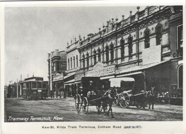
Postcard, Tramway Terminus, Kew, 1913
This work forms part of the collection assembled by the historian Dorothy Rogers, that was donated to the Kew Historical Society by her son John Rogers in 2015. The manuscripts, photographs, maps, and documents were sourced by her from both family and local collections or produced as references for her print publications. Many were directly used by Rogers in writing ‘Lovely Old Homes of Kew’ (1961) and 'A History of Kew' (1973), or the numerous articles on local history that she produced for suburban newspapers. Most of the photographs in the collection include detailed annotations in her hand. The Rogers Collection provides a comprehensive insight into the working habits of a historian in the 1960s and 1970s. Together it forms the largest privately-donated collection within the archives of the Kew Historical Society.A copy of a book plate in Vaughan in 'Kew's Civic Century' (1960) which was itself a copy of a postcard from circa 1913."tram about 1913. Terminus, Cotham Road. Tramway Terminus, Kew. Kew-St Kilda Tram Terminus, Cotham Road (see p.47)"cotham road (kew), dorothy rogers, postcards - kew (vic.) -
 Kew Historical Society Inc
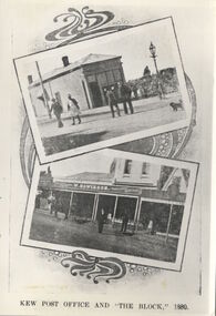
Print, FGA Barnard, Kew Post Office and 'The Block' 1880
This work forms part of the collection assembled by the historian Dorothy Rogers, that was donated to the Kew Historical Society by her son John Rogers in 2015. The manuscripts, photographs, maps, and documents were sourced by her from both family and local collections or produced as references for her print publications. Many were directly used by Rogers in writing ‘Lovely Old Homes of Kew’ (1961) and 'A History of Kew' (1973), or the numerous articles on local history that she produced for suburban newspapers. Most of the photographs in the collection include detailed annotations in her hand.The Rogers Collection provides a comprehensive insight into the working habits of a historian in the 1960s and 1970s. Together it forms the largest privately-donated collection within the archives of the Kew Historical Society.A print made for Dorothy Rogers of a book plate originally published in F.G.A. Barnards 'Jubilee History of Kew' (1910) showing a view of Barnard's pharmacy and post office on the corner of High Street and Cotham Road, where the Kew Post Office was to be built in 1888."Barnard's Post Office on present P.O. corner prior to 1880. 1st P.O. was in Houwiesons Shop. This is the site of The Block . See other photo"francis barnard, dorothy rogers, kew post office -
 Kew Historical Society Inc
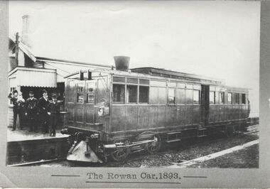
Photograph, The Rowan Car, 1893
This work forms part of the collection assembled by the historian Dorothy Rogers, that was donated to the Kew Historical Society by her son John Rogers in 2015. The manuscripts, photographs, maps, and documents were sourced by her from both family and local collections or produced as references for her print publications. Many were directly used by Rogers in writing ‘Lovely Old Homes of Kew’ (1961) and 'A History of Kew' (1973), or the numerous articles on local history that she produced for suburban newspapers. Most of the photographs in the collection include detailed annotations in her hand.The Rogers Collection provides a comprehensive insight into the working habits of a historian in the 1960s and 1970s. Together it forms the largest privately-donated collection within the archives of the Kew Historical Society.A print made by/for Dorothy Rogers in the 1960s from an original in the La Trobe Library (State Library of Victoria) showing one of the trains on the Outer Circle Railway."Train used on Outer Circle Railway 1893. Only ones available supplied by La Trobe Library"outer circle railway, rowan car, dorothy rogers -
 Kew Historical Society Inc
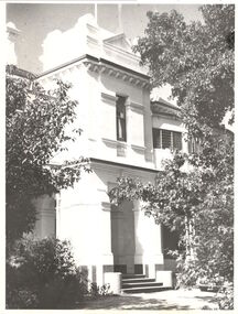
Photograph, 'Roberts House', Trinity Grammar School, c. 1965
The Argus in November 1924 reported the purchase of Elsinore by Trinity Grammar School. "The council of Trinity Grammar School, Kew, has purchased Elsinore, the residence of the late Mr. V. J. Saddler, at the corner of Wellington street, Stanley street, and Charles street, Kew, which adjoins the property recently purchased from Mr. J. Henning Thompson (known as 'Trinity Lodge), and is directly opposite the Headmaster's house and main school grounds.This work forms part of the collection assembled by the historian Dorothy Rogers, that was donated to the Kew Historical Society by her son John Rogers in 2015. The manuscripts, photographs, maps, and documents were sourced by her from both family and local collections or produced as references for her print publications. Many were directly used by Rogers in writing ‘Lovely Old Homes of Kew’ (1961) and 'A History of Kew' (1973), or the numerous articles on local history that she produced for suburban newspapers. Most of the photographs in the collection include detailed annotations in her hand. The Rogers Collection provides a comprehensive insight into the working habits of a historian in the 1960s and 1970s. Together it forms the largest privately-donated collection within the archives of the Kew Historical Society.The central tower of Roberts House (originally 'Elsinore'), Wellington Street, Kew. Part of Trinity Grammar School since 1924.4. Roberts House. Trinity Grammar School.roberts house, trinity grammar school, elsinore -
 Kew Historical Society Inc
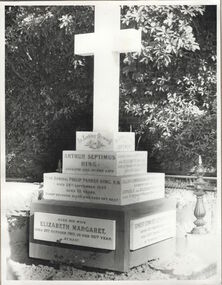
Photograph, King family memorial, Boroondara General Cemetery, circa 1965, c. 1965
This work forms part of the collection assembled by the historian Dorothy Rogers, that was donated to the Kew Historical Society by her son John Rogers in 2015. The manuscripts, photographs, maps, and documents were sourced by her from both family and local collections or produced as references for her print publications. Many were directly used by Rogers in writing ‘Lovely Old Homes of Kew’ (1961) and 'A History of Kew' (1973), or the numerous articles on local history that she produced for suburban newspapers. Most of the photographs in the collection include detailed annotations in her hand. The Rogers Collection provides a comprehensive insight into the working habits of a historian in the 1960s and 1970s. Together it forms the largest privately-donated collection within the archives of the Kew Historical Society.Photograph, taken by/or for the historian Dorothy Rogers, of the King family grave at Boroondara General Cemetery. Rogers was to write an entry on the King brothers that was published in the Australian Dictionary of Biography."Memorial to Arthur Septimus King & Family. Kew Cemetery. Plaque in Church"arthur septimus king, boroondara general cemetery, dorothy rogers -
 Kew Historical Society Inc
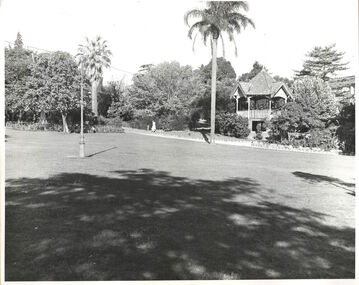
Photograph, Alexandra Gardens, c.1960
Rotunda, Alexandra Gardens (1910-c.1960). The Alexandra Gardens’ rotunda was located within three acres of ‘gem like’ gardens ‘bright with verdant lawns and choice blooms’ in the centre of Kew. Designed by architects Grainger and Little, the ornate two-storey wooden kiosk functioned as a children’s shelter on the ground level and a bandstand and oratory dais on the upper. Funded by council and community subscription, it was a ‘symbol of the public spirit of Victoria’ and a Kew Jubilee commemoration memorial. Opened in 1910, the Kew Brass Band christened it the ‘finest band rotunda in Melbourne’. Deterioration saw its demise 50 years later. This work forms part of the collection assembled by the historian Dorothy Rogers, that was donated to the Kew Historical Society by her son John Rogers in 2015. The manuscripts, photographs, maps, and documents were sourced by her from both family and local collections or produced as references for her print publications. Many were directly used by Rogers in writing ‘Lovely Old Homes of Kew’ (1961) and 'A History of Kew' (1973), or the numerous articles on local history that she produced for suburban newspapers. Most of the photographs in the collection include detailed annotations in her hand. The Rogers Collection provides a comprehensive insight into the working habits of a historian in the 1960s and 1970s. Together it forms the largest privately-donated collection within the archives of the Kew Historical Society.Lawn and original rotunda in the Alexandra Gardens, Cotham Road, Kew. The Alexandra Gardens were opened in 1908. The land on which the gardens were formed originally formed part of the Madford Estate. A feature of the gardens was a large brick, wood and tiled rotunda. "Alexandra Gardens. Formerly part of S. King. (Rest of Estate mainly belongs to St Anthonys home). Opened 1908. Alexandra Gardens. (Rotunda now demolished)"alexandra gardens, kew, dorothy rogers -
 Kew Historical Society Inc
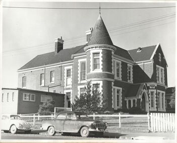
Photograph, Kew RSL, Cotham Road, circa 1965, c. 1965
The Kew RSL is located in "Wilton" House, 63 Cotham Road. The RSL was established on January 1st 1920, later joining with the Hawthorn RSL. In November 1931, Cr. C.R. Parry organised the reformation of the Kew Sub Branch and its first president was Brig-Gen Pat McGlin, a veteran of the Boer War and the First World War. On July 17th 1932, the club rooms first opened on Army land at the corner of High Street and Highbury Grove. In late November 1948, the Kew RSL bought the "Wilton" house from the Kew City Council for £10,067, opening seven years later in July 1955. [Source: Victorian Heritage Database]This work forms part of the collection assembled by the historian Dorothy Rogers, that was donated to the Kew Historical Society by her son John Rogers in 2015. The manuscripts, photographs, maps, and documents were sourced by her from both family and local collections or produced as references for her print publications. Many were directly used by Rogers in writing ‘Lovely Old Homes of Kew’ (1961) and 'A History of Kew' (1973), or the numerous articles on local history that she produced for suburban newspapers. Most of the photographs in the collection include detailed annotations in her hand. The Rogers Collection provides a comprehensive insight into the working habits of a historian in the 1960s and 1970s. Together it forms the largest privately-donated collection within the archives of the Kew Historical Society.The exterior of the Kew RSL on the corner of Cotham Road and Charles Street, Kew. Designed by Guyon Purchase for Dr. William Walsh in 1886, the building was originally called Wilton."Chap 59. Cotham Rd. Built/Commences about 1885-6. Present day Wilton . Kew RSSUILA rooms. (Rumour of sale 1972?)"wilton, dr william walsh, guyon purchas, dorothy rogers, cotham road (kew) -
 Kew Historical Society Inc
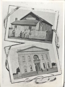
Print, FGA Barnard, Athenaeum Hall & Kew Town Hall, 1910
This work forms part of the collection assembled by the historian Dorothy Rogers, that was donated to the Kew Historical Society by her son John Rogers in 2015. The manuscripts, photographs, maps, and documents were sourced by her from both family and local collections or produced as references for her print publications. Many were directly used by Rogers in writing ‘Lovely Old Homes of Kew’ (1961) and 'A History of Kew' (1973), or the numerous articles on local history that she produced for suburban newspapers. Most of the photographs in the collection include detailed annotations in her hand. The Rogers Collection provides a comprehensive insight into the working habits of a historian in the 1960s and 1970s. Together it forms the largest privately-donated collection within the archives of the Kew Historical Society.A photographic copy of a book plate made for the historian Dorothy Rogers which was first published in the 'Jubilee History of Kew' (1910) by F.G.A. Barnard"Athenaeum built 1860. 1865 purchased & Town Hall built around it. Later a new front was added as in picture - note old lamps - At present under demolition for Safeways Store"athenaeum hall, walpole street, kew town hall, walpole street, dorothy rogers -
 Kew Historical Society Inc
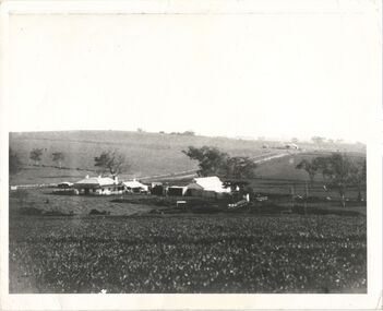
Photograph, Kilby Farm, Kew East, Before 1920
Kilby Lodge (c.1845-c.1922). William Oswin purchased Crown Land Lots 52 & 53 in 1845. These lots ran north from an old bullock track [later Kilby Road] to the Yarra, and east to Burke Road. Oswin purchased a neighbouring Lot in 1851, separated by the bullock track from the rest of the farm. Oswin built ‘Kilby Lodge’ and, with his brother, farmed dairy cattle on the site. Oswin’s descendants owned the farm into the 1890s. New subdivisions of Kilby and neighbouring farms in the 1920s changed the rural nature of north Kew. Housing and large recreation reserves replaced dairy farms and market gardens. This work forms part of the collection assembled by the historian Dorothy Rogers, that was donated to the Kew Historical Society by her son John Rogers in 2015. The manuscripts, photographs, maps, and documents were sourced by her from both family and local collections or produced as references for her print publications. Many were directly used by Rogers in writing ‘Lovely Old Homes of Kew’ (1961) and 'A History of Kew' (1973), or the numerous articles on local history that she produced for suburban newspapers. Most of the photographs in the collection include detailed annotations in her hand. The Rogers Collection provides a comprehensive insight into the working habits of a historian in the 1960s and 1970s. Together it forms the largest privately-donated collection within the archives of the Kew Historical Society.A panoramic photograph of Kilby (or Oswin's) Farm in East Kew."Kilby Farm when Oswins owned it. Commenced 1845."kilby farm, kilby lodge, william oswin, dorothy rogers, kew east -
 Kew Historical Society Inc
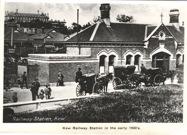
Print, Kew Railway Station in the early 1900s, c.1900
Kew Railway Station (1887-1959). ‘Kew Railway Station’ in Denmark Street was the terminus of the Kew Line, which extended from Hawthorn Station to just south of Wellington Street. The Station opened on 19 December 1887 after a prolonged campaign for a railway by the people of Kew. Due to a decline in patronage, the passenger service ceased operations in August 1952. While a freight service continued for another five years, the line and station were officially closed on 13 May 1957. Subsequently demolished in 1959, the headquarters of VicRoads (formerly Country Roads Board) now stands on the former Station site.This work forms part of the collection assembled by the historian Dorothy Rogers, that was donated to the Kew Historical Society by her son John Rogers in 2015. The manuscripts, photographs, maps, and documents were sourced by her from both family and local collections or produced as references for her print publications. Many were directly used by Rogers in writing ‘Lovely Old Homes of Kew’ (1961) and 'A History of Kew' (1973), or the numerous articles on local history that she produced for suburban newspapers. Most of the photographs in the collection include detailed annotations in her hand. The Rogers Collection provides a comprehensive insight into the working habits of a historian in the 1960s and 1970s. Together it forms the largest privately-donated collection within the archives of the Kew Historical Society.A photographic copy of a book plate from 'Kew's Civic Century' (1960) by W.D. Vaughan. The book plate was itself a copy of an early 20th century postcard depicting the Kew Railway Station."Railway opened 1887 - Then as photo states"kew railway station, dorothy rogers, country roads board, vicroads -
 Kew Historical Society Inc
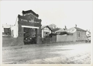
Photograph, Kew Fire Brigade, Walton Street, c.1912
The Walton Street Fire Brigade building was constructed in 1893 (Rogers, 1973) replacing an earlier building on the site constructed for the Kew Volunteer Fire brigade. The building was demolished in 1941. In the background of the photo is a nouse on the corner of Peel and Walton Street which was also constructed in 1893 and which was to house a fireman from the brigade.This work forms part of the collection assembled by the historian Dorothy Rogers, that was donated to the Kew Historical Society by her son John Rogers in 2015. The manuscripts, photographs, maps, and documents were sourced by her from both family and local collections or produced as references for her print publications. Many were directly used by Rogers in writing ‘Lovely Old Homes of Kew’ (1961) and 'A History of Kew' (1973), or the numerous articles on local history that she produced for suburban newspapers. Most of the photographs in the collection include detailed annotations in her hand. The Rogers Collection provides a comprehensive insight into the working habits of a historian in the 1960s and 1970s. Together it forms the largest privately-donated collection within the archives of the Kew Historical Society.A photographic print of the Kew Fire Brigade, presumably copied from W.D. Vaughan's 'Kew's Civic Century' (1960)."2nd Fire Brigade, Walton St., taken shortly before Belford Rd., built. (Demolished). 2nd fire brigade, Walton St., Kew. No photo of 1st except on membership certificate."kew fire brigade, walton street - kew -
 Kew Historical Society Inc
Photograph, Chipperfield's Boat House & Floating Pontoon, c.1939
Several boathouses were built in Kew and Fairfield in the late 19th and early 20th centuries. They included Chipperfield’s ‘Moorings’ and floating pontoon. The substantial two-storey house was named the Moorings, and incorporated an upper storey residence. The Moorings was almost washed away in the 1916 floods, and in 1934 almost totally submerged when the Yarra River rose 26 feet in 14 hours. Following the 1934 flood, the house was restored. The floating pontoon, sometimes referred to as a ‘kiosk’ or ‘canteen’, was used to store canoes. Both were removed in 1972 for the construction of the Eastern Freeway.This work forms part of the collection assembled by the historian Dorothy Rogers, that was donated to the Kew Historical Society by her son John Rogers in 2015. The manuscripts, photographs, maps, and documents were sourced by her from both family and local collections or produced as references for her print publications. Many were directly used by Rogers in writing ‘Lovely Old Homes of Kew’ (1961) and 'A History of Kew' (1973), or the numerous articles on local history that she produced for suburban newspapers. Most of the photographs in the collection include detailed annotations in her hand. The Rogers Collection provides a comprehensive insight into the working habits of a historian in the 1960s and 1970s. Together it forms the largest privately-donated collection within the archives of the Kew Historical Society.Chipperfield's Floating Canteen (also known as the pontoon) on the Yarra River. at North Kew The children wading in the river are believed to be the three sons of Dorothy Rogers."Chipperfield's Floating Canteen & house in background. At extreme right - observe channel where Connors Creek flows in."chipperfield's boat house, river yarra, dorothy rogers, floods 1916, 1934 -
 Kew Historical Society Inc
Plan, Studley Park Estate, 1910
Prue Sanderson, in her groundbreaking ‘City of Kew Urban Conservation Study : Volume 2 - Development History’ (1988), summarised the periods of urban development and subdivisions of land in Kew. The periods that she identified included 1845-1880, 1880-1893, 1893-1921, 1921-1933, 1933-1943, and Post-War Development. These periods were selected as they represented periods of rapid growth or decline in urban development. An obvious starting point for Sanderson’s groupings involved population growth and the associated economic cycles. These cycles also highlighted urban expansion onto land that was predominantly rural, although in other cases it represented the decline and breakup of large estates. A number of the plans in the Kew Historical Society’s collection can also be found in other collections, such as those of the State Library of Victoria and the Boroondara Library Service. A number are however unique to the collection.The Kew Historical Society collection includes almost 100 subdivision plans pertaining to suburbs of the City of Melbourne. Most of these are of Kew, Kew East or Studley Park, although a smaller number are plans of Camberwell, Deepdene, Balwyn and Hawthorn. It is believed that the majority of the plans were gifted to the Society by persons connected with the real estate firm - J. R. Mathers and McMillan, 136 Cotham Road, Kew. The Plans in the collection are rarely in pristine form, being working plans on which the agent would write notes and record lots sold and the prices of these. The subdivision plans are historically significant examples of the growth of urban Melbourne from the beginning of the 20th Century up until the 1980s. A number of the plans are double-sided and often include a photograph on the reverse. A number of the latter are by noted photographers such as J.E. Barnes.Coloured lithograph of a subdivision plan of the Studley Park Estate, bordered by Yarra, Willsmere Road and the Outer Circle Railway line. The estate was listed in 1910 and was the subject of a planning dispute between the developer and the Town of Kew in relation to flood levels and the suitability of the land for housing. In many cases the names of streets were subsequently changed. The layout was also affected by the creation of the Eastern Freeway. A newspaper report of the day described the subdivision as a: "GOLDEN OPPORTUNITY. We are pleased to submit for PRIVATE SALE that magnificent ESTATE, situated only 4 1/2 miles from the Melbourne General Post Office, STUDLEY PARK ESTATE. KF/NV. Doubtless the CHEAPEST LAND EVER OFFERED having extensive frontages to the prettiest spot on the River Yarra and the National Park, commanding lovely river and landscape views, and acknowledged to be the finest land available so close to the city. The PRICES ARE EXTREMELY MODERATE; The TERMS ARE SIMPLY MARVELLOUS. NO DEPOSIT. NO DEPOSIT. NO DEPOSIT. Allotments and prices to suit everyone."subdivision plans - kew, studley park estate -
 Kew Historical Society Inc
Plan - Subdivision Plan, Goldthorns House Estate, 1940
Pru Sanderson, in her groundbreaking ‘City of Kew Urban Conservation Study : Volume 2 - Development History’ (1988), summarised the periods of urban development and subdivisions of land in Kew. The periods that she identified included 1845-1880, 1880-1893, 1893-1921, 1921-1933, 1933-1943, and Post-War Development. These periods were selected as they represented periods of rapid growth or decline in urban development. An obvious starting point for Sanderson’s groupings involved population growth and the associated economic cycles. These cycles also highlighted urban expansion onto land that was predominantly rural, although in other cases it represented the decline and breakup of large estates. A number of the plans in the Kew Historical Society’s collection can also be found in other collections, such as those of the State Library of Victoria and the Boroondara Library Service. A number are however unique to the collection.The Kew Historical Society collection includes almost 100 subdivision plans pertaining to suburbs of the City of Melbourne. Most of these are of Kew, Kew East or Studley Park, although a smaller number are plans of Camberwell, Deepdene, Balwyn and Hawthorn. It is believed that the majority of the plans were gifted to the Society by persons connected with the real estate firm - J. R. Mathers and McMillan, 136 Cotham Road, Kew. The Plans in the collection are rarely in pristine form, being working plans on which the agent would write notes and record lots sold and the prices of these. The subdivision plans are historically significant examples of the growth of urban Melbourne from the beginning of the 20th Century up until the 1980s. A number of the plans are double-sided and often include a photograph on the reverse. A number of the latter are by noted photographers such as J.E. Barnes.The first subdivision of Goldthorns created the Goldthorns Hill Estate. Following that subdivision, seven additional lots were offered between Normanby Road, Argyle Road and Lady Loch’s Drive on the proviso that the estate, including Goldthorns was not sold as a single lot. The subdivision plan advises that the lots are situated in one of the most charming and popular residential areas in Kew and is surrounded by modern homes. Typically, the subdivision plan proposes the advantage of its proximity to Cotham Road and the tram to Collins Street. Because of the elevation of Goldthorns, much is made of the ‘bright, sunny and extensive outlook to the Northern Ranges’ and that it overlooks the Yarra Valley. One of the more interesting aspects of the plan is that it shows the outline of Goldthorns in the mid to late 1920s. Its profile today remains virtually the same."Goldthorns" House Estate at topsubdivision plans - kew, goldthorns house estate -
 Kew Historical Society Inc
Plan, Sydney Arnold Best & Co, Field Place, Kew, c.1929
Pru Sanderson, in her groundbreaking ‘City of Kew Urban Conservation Study : Volume 2 - Development History’ (1988), summarised the periods of urban development and subdivisions of land in Kew. The periods that she identified included 1845-1880, 1880-1893, 1893-1921, 1921-1933, 1933-1943, and Post-War Development. These periods were selected as they represented periods of rapid growth or decline in urban development. An obvious starting point for Sanderson’s groupings involved population growth and the associated economic cycles. These cycles also highlighted urban expansion onto land that was predominantly rural, although in other cases it represented the decline and breakup of large estates. A number of the plans in the Kew Historical Society’s collection can also be found in other collections, such as those of the State Library of Victoria and the Boroondara Library Service. A number are however unique to the collection.The Kew Historical Society collection includes almost 100 subdivision plans pertaining to suburbs of the City of Melbourne. Most of these are of Kew, Kew East or Studley Park, although a smaller number are plans of Camberwell, Deepdene, Balwyn and Hawthorn. It is believed that the majority of the plans were gifted to the Society by persons connected with the real estate firm - J. R. Mathers and McMillan, 136 Cotham Road, Kew. The Plans in the collection are rarely in pristine form, being working plans on which the agent would write notes and record lots sold and the prices of these. The subdivision plans are historically significant examples of the growth of urban Melbourne from the beginning of the 20th Century up until the 1980s. A number of the plans are double-sided and often include a photograph on the reverse. A number of the latter are by noted photographers such as J.E. Barnes.An unnamed subdivision in Studley Park including five lots for sale in Studley Park Road, Highfield Grove and Tara Avenue. Unidentified on the plan, but clearly existing, are the Henty family mansion of Field Place and Tara Hall in Studley Park Road. The first attempted subdivision of Tara Hall was advertised in 1927 in which Lots 5, 6 and 7 in this plan were also advertised. Unusually, Lot 2 in Studley Park Road was created from the northern part of the Henty mansion, rather than Tara Hall. In the subdivision, lots were advertised at varying prices, with the highest price for land being Lot 2 in Studley Park Road. The plan notes that only one villa is to be allowed on each allotment.subdivision plans - kew, field place subdivision -- studley park – kew (vic.), highfield grove – kew (vic.), tara avenue – kew (vic.) -
 Kew Historical Society Inc
Plan - Subdivision Plan, Altyre Estate, 1920, 1920
Pru Sanderson, in her groundbreaking ‘City of Kew Urban Conservation Study : Volume 2 - Development History’ (1988), summarised the periods of urban development and subdivisions of land in Kew. The periods that she identified included 1845-1880, 1880-1893, 1893-1921, 1921-1933, 1933-1943, and Post-War Development. These periods were selected as they represented periods of rapid growth or decline in urban development. An obvious starting point for Sanderson’s groupings involved population growth and the associated economic cycles. These cycles also highlighted urban expansion onto land that was predominantly rural, although in other cases it represented the decline and breakup of large estates. A number of the plans in the Kew Historical Society’s collection can also be found in other collections, such as those of the State Library of Victoria and the Boroondara Library Service. A number are however unique to the collection.The Kew Historical Society collection includes almost 100 subdivision plans pertaining to suburbs of the City of Melbourne. Most of these are of Kew, Kew East or Studley Park, although a smaller number are plans of Camberwell, Deepdene, Balwyn and Hawthorn. It is believed that the majority of the plans were gifted to the Society by persons connected with the real estate firm - J. R. Mathers and McMillan, 136 Cotham Road, Kew. The Plans in the collection are rarely in pristine form, being working plans on which the agent would write notes and record lots sold and the prices of these. The subdivision plans are historically significant examples of the growth of urban Melbourne from the beginning of the 20th Century up until the 1980s. A number of the plans are double-sided and often include a photograph on the reverse. A number of the latter are by noted photographers such as J.E. Barnes.The Altyre Estate was advertised for sale by auction in 1920. A colour lithograph in the State Library of Victoria, in contrast to this monochrome version, notes the proximity of the subdivision to the Auburn Heights Bowling Club and to a range of transport options. The subdivision included fifty-one allotments as well as the original house ‘Altyre’ in Barkers Road. This version includes the amounts paid as deposit on a number of lots.subdivision plans - kew, altyre estate – kew (vic), barkers road – kew (vic), walsh street – kew (vic), ross street – kew (vic), loxton street – kew (vic), mount street – kew (vic), auburn heights bowling club, altyre -
 Kew Historical Society Inc
Plan - Subdivision Plan, Summerhill Estate, 1920-1940
Pru Sanderson, in her groundbreaking ‘City of Kew Urban Conservation Study : Volume 2 - Development History’ (1988), summarised the periods of urban development and subdivisions of land in Kew. The periods that she identified included 1845-1880, 1880-1893, 1893-1921, 1921-1933, 1933-1943, and Post-War Development. These periods were selected as they represented periods of rapid growth or decline in urban development. An obvious starting point for Sanderson’s groupings involved population growth and the associated economic cycles. These cycles also highlighted urban expansion onto land that was predominantly rural, although in other cases it represented the decline and breakup of large estates. A number of the plans in the Kew Historical Society’s collection can also be found in other collections, such as those of the State Library of Victoria and the Boroondara Library Service. A number are however unique to the collection.The Kew Historical Society collection includes almost 100 subdivision plans pertaining to suburbs of the City of Melbourne. Most of these are of Kew, Kew East or Studley Park, although a smaller number are plans of Camberwell, Deepdene, Balwyn and Hawthorn. It is believed that the majority of the plans were gifted to the Society by persons connected with the real estate firm - J. R. Mathers and McMillan, 136 Cotham Road, Kew. The Plans in the collection are rarely in pristine form, being working plans on which the agent would write notes and record lots sold and the prices of these. The subdivision plans are historically significant examples of the growth of urban Melbourne from the beginning of the 20th Century up until the 1980s. A number of the plans are double-sided and often include a photograph on the reverse. A number of the latter are by noted photographers such as J.E. Barnes.The Summerhill Estate was a subdivision in Glen Iris of 24 ‘choice allotments’. The lots were primarily on both sides of Dillon Grove. Other lots at each end of the subdivision faced Margaret Street and Summerhill Road. It was from the latter that the subdivision took its advertised title. The lots were originally advertised for £10 deposit with 20 subsequent payments over five years. Pencilled on the printed plan is a change to the deposit required; a reduction to 20/-. Annotations indicate that the new deposits ranged from 30/- to 45/-. The most expensive lots faced Summerhill Road. This subdivision plan is unusual in that the front and rear of the card are for subdivisions in different localities.subdivision plans - glen iris, summerhill estate -
 Kew Historical Society Inc
Plan - Subdivision Plan, Old Kew Golf Links Estate - Third Section, 1920-1929
Pru Sanderson, in her groundbreaking ‘City of Kew Urban Conservation Study : Volume 2 - Development History’ (1988), summarised the periods of urban development and subdivisions of land in Kew. The periods that she identified included 1845-1880, 1880-1893, 1893-1921, 1921-1933, 1933-1943, and Post-War Development. These periods were selected as they represented periods of rapid growth or decline in urban development. An obvious starting point for Sanderson’s groupings involved population growth and the associated economic cycles. These cycles also highlighted urban expansion onto land that was predominantly rural, although in other cases it represented the decline and breakup of large estates. A number of the plans in the Kew Historical Society’s collection can also be found in other collections, such as those of the State Library of Victoria and the Boroondara Library Service. A number are however unique to the collection.The Kew Historical Society collection includes almost 100 subdivision plans pertaining to suburbs of the City of Melbourne. Most of these are of Kew, Kew East or Studley Park, although a smaller number are plans of Camberwell, Deepdene, Balwyn and Hawthorn. It is believed that the majority of the plans were gifted to the Society by persons connected with the real estate firm - J. R. Mathers and McMillan, 136 Cotham Road, Kew. The Plans in the collection are rarely in pristine form, being working plans on which the agent would write notes and record lots sold and the prices of these. The subdivision plans are historically significant examples of the growth of urban Melbourne from the beginning of the 20th Century up until the 1980s. A number of the plans are double-sided and often include a photograph on the reverse. A number of the latter are by noted photographers such as J.E. Barnes.When the old Kew Golf Links was subdivided in the mid 1920s, the developers were able to break the sale into sections. The third section included eighty lots. The lots faced Kilby Road, Kodak Avenue, Belford Road, Baker Avenue, Mathers Avenue, and White Avenue. [Kodak Avenue was renamed Page Avenue at a later date].The ‘Kew Conservation Study (1988) notes that ‘On the subdivision plan, Kodak’s involvement is commemorated by the naming of the streets after Company directors, and their decision to not proceed with the construction of the factory is explained as a response to the increase in the value of the land. This explanation may have been Estate Agent’s hyperbole, as the Kodak Company records suggest that the land, with its wide creek gully, was unsuitable and too small for its purposes.subdivision plans - kew, old kew golf links estate - third section -
 Kew Historical Society Inc
Plan - Subdivision Plan, Birdwood Estate, 1920
Pru Sanderson, in her groundbreaking ‘City of Kew Urban Conservation Study : Volume 2 - Development History’ (1988), summarised the periods of urban development and subdivisions of land in Kew. The periods that she identified included 1845-1880, 1880-1893, 1893-1921, 1921-1933, 1933-1943, and Post-War Development. These periods were selected as they represented periods of rapid growth or decline in urban development. An obvious starting point for Sanderson’s groupings involved population growth and the associated economic cycles. These cycles also highlighted urban expansion onto land that was predominantly rural, although in other cases it represented the decline and breakup of large estates. A number of the plans in the Kew Historical Society’s collection can also be found in other collections, such as those of the State Library of Victoria and the Boroondara Library Service. A number are however unique to the collection.The Kew Historical Society collection includes almost 100 subdivision plans pertaining to suburbs of the City of Melbourne. Most of these are of Kew, Kew East or Studley Park, although a smaller number are plans of Camberwell, Deepdene, Balwyn and Hawthorn. It is believed that the majority of the plans were gifted to the Society by persons connected with the real estate firm - J. R. Mathers and McMillan, 136 Cotham Road, Kew. The Plans in the collection are rarely in pristine form, being working plans on which the agent would write notes and record lots sold and the prices of these. The subdivision plans are historically significant examples of the growth of urban Melbourne from the beginning of the 20th Century up until the 1980s. A number of the plans are double-sided and often include a photograph on the reverse. A number of the latter are by noted photographers such as J.E. Barnes.Bordering Burke Road, the Birdwood Estate included a subdivision of 34 lots on either side of Birdwood Street, Balwyn. Six of the lots faced Burke Road. At the other end of the subdivision a line would indicate that a creek once bordered the subdivision. Lots were advertised for sale at a low figure on five-year terms. Purchasers could pay off the balance in twenty quarterly instalments (i.e. over five years).subdivision plans - balwyn, birdwood estate -
 Kew Historical Society Inc
Plan - Subdivision Plan, Mayfield Estate, 1927
A number of the plans in the Kew Historical Society’s collection can also be found in other collections, such as those of the State Library of Victoria. A number are however unique to the collection.The Kew Historical Society collection includes almost 100 subdivision plans pertaining to suburbs of the City of Melbourne. Most of these are of Kew, Kew East or Studley Park, although a smaller number are plans of Camberwell, Deepdene, Balwyn and Hawthorn. It is believed that the majority of the plans were gifted to the Society by persons connected with the real estate firm - J. R. Mathers and McMillan, 136 Cotham Road, Kew. The Plans in the collection are rarely in pristine form, being working plans on which the agent would write notes and record lots sold and the prices of these. The subdivision plans are historically significant examples of the growth of urban Melbourne from the beginning of the 20th Century up until the 1980s. A number of the plans are double-sided and often include a photograph on the reverse. A number of the latter are by noted photographers such as J.E. Barnes.The Mayfield Estate subdivision included 14 allotments surrounding Evan Court (now Evans Court) in Toorak. The subdivision adjoined Toorak Road east of Kooyong Road and alerted prospective buyers to how the Toorak Road tram would take them directly to the city. This emphasis on existing transport routes was a feature of subdivisions during a period when car ownership was the preserve of the wealthy. An existing brick villa (‘Mayfield’) is noted as already constructed on lot 13. The subdivision also notes that the lots adjoin land owned by Sir Edward Miller. Today Evans Court extends beyond this subdivision through to Moonga Road.subdivision plans - toorak, mayfield estate, sir edward miller -
 Kew Historical Society Inc
Plan - Subdivision Plan, Bonnie Doon Estate, c.1908
Pru Sanderson, in her groundbreaking ‘City of Kew Urban Conservation Study : Volume 2 - Development History’ (1988), summarised the periods of urban development and subdivisions of land in Kew. The periods that she identified included 1845-1880, 1880-1893, 1893-1921, 1921-1933, 1933-1943, and Post-War Development. These periods were selected as they represented periods of rapid growth or decline in urban development. An obvious starting point for Sanderson’s groupings involved population growth and the associated economic cycles. These cycles also highlighted urban expansion onto land that was predominantly rural, although in other cases it represented the decline and breakup of large estates. A number of the plans in the Kew Historical Society’s collection can also be found in other collections, such as those of the State Library of Victoria and the Boroondara Library Service. A number are however unique to the collection.The Kew Historical Society collection includes almost 100 subdivision plans pertaining to suburbs of the City of Melbourne. Most of these are of Kew, Kew East or Studley Park, although a smaller number are plans of Camberwell, Deepdene, Balwyn and Hawthorn. It is believed that the majority of the plans were gifted to the Society by persons connected with the real estate firm - J. R. Mathers and McMillan, 136 Cotham Road, Kew. The Plans in the collection are rarely in pristine form, being working plans on which the agent would write notes and record lots sold and the prices of these. The subdivision plans are historically significant examples of the growth of urban Melbourne from the beginning of the 20th Century up until the 1980s. A number of the plans are double-sided and often include a photograph on the reverse. A number of the latter are by noted photographers such as J.E. Barnes.The subdivision advertised as the Bonnie Doon Estate in Greensborough was first advertised in 1908. At that stage, the new subdivision included 15 allotments of between one and four acres. By the time the subdivision plan in the Kew Collection was created, only 12 lots of between ¾ and 2½ acres remained. Both the State Library and Kew plans emphasise the distance to the city being 13½ miles, which could be reached by train on weekdays and weekends. Unusually, the plan describes the suitability of lots as locations for ‘Week-end Homes’. Correspondingly, the train line is described as ‘The Holiday Resort for the Northern Suburbs’.bonnie doona estate, subdivision plans - greensborough -
 Kew Historical Society Inc
Plan - Subdivision Plan, Cotham Vale Estate, 1919
Pru Sanderson, in her groundbreaking ‘City of Kew Urban Conservation Study : Volume 2 - Development History’ (1988), summarised the periods of urban development and subdivisions of land in Kew. The periods that she identified included 1845-1880, 1880-1893, 1893-1921, 1921-1933, 1933-1943, and Post-War Development. These periods were selected as they represented periods of rapid growth or decline in urban development. An obvious starting point for Sanderson’s groupings involved population growth and the associated economic cycles. These cycles also highlighted urban expansion onto land that was predominantly rural, although in other cases it represented the decline and breakup of large estates. A number of the plans in the Kew Historical Society’s collection can also be found in other collections, such as those of the State Library of Victoria and the Boroondara Library Service. A number are however unique to the collection.The Kew Historical Society collection includes almost 100 subdivision plans pertaining to suburbs of the City of Melbourne. Most of these are of Kew, Kew East or Studley Park, although a smaller number are plans of Camberwell, Deepdene, Balwyn and Hawthorn. It is believed that the majority of the plans were gifted to the Society by persons connected with the real estate firm - J. R. Mathers and McMillan, 136 Cotham Road, Kew. The Plans in the collection are rarely in pristine form, being working plans on which the agent would write notes and record lots sold and the prices of these. The subdivision plans are historically significant examples of the growth of urban Melbourne from the beginning of the 20th Century up until the 1980s. A number of the plans are double-sided and often include a photograph on the reverse. A number of the latter are by noted photographers such as J.E. Barnes.The Cotham Vale Estate was a subdivision of land between Alfred, Thomas, Rowland and John Streets. It was promoted in the same time as the nearby Normanby Heights Estate. Cotham Vale included 28 allotments. Contemporary newspaper advertisements noted that the Estate ‘is most conveniently situated in a well elevated position, only 2 minutes from Cotham rd. Electric Cars, penny section to Kew station’.subdivision plans - kew, cotham vale estate, rowland street -- kew (vic.), thomas street -- kew (vic.), john street -- kew (vic.) -
 Kew Historical Society Inc
Plan - Subdivision Plan, Golf View Estate, c.1922
Pru Sanderson, in her groundbreaking ‘City of Kew Urban Conservation Study : Volume 2 - Development History’ (1988), summarised the periods of urban development and subdivisions of land in Kew. The periods that she identified included 1845-1880, 1880-1893, 1893-1921, 1921-1933, 1933-1943, and Post-War Development. These periods were selected as they represented periods of rapid growth or decline in urban development. An obvious starting point for Sanderson’s groupings involved population growth and the associated economic cycles. These cycles also highlighted urban expansion onto land that was predominantly rural, although in other cases it represented the decline and breakup of large estates. A number of the plans in the Kew Historical Society’s collection can also be found in other collections, such as those of the State Library of Victoria and the Boroondara Library Service. A number are however unique to the collection.The Kew Historical Society collection includes almost 100 subdivision plans pertaining to suburbs of the City of Melbourne. Most of these are of Kew, Kew East or Studley Park, although a smaller number are plans of Camberwell, Deepdene, Balwyn and Hawthorn. It is believed that the majority of the plans were gifted to the Society by persons connected with the real estate firm - J. R. Mathers and McMillan, 136 Cotham Road, Kew. The Plans in the collection are rarely in pristine form, being working plans on which the agent would write notes and record lots sold and the prices of these. The subdivision plans are historically significant examples of the growth of urban Melbourne from the beginning of the 20th Century up until the 1980s. A number of the plans are double-sided and often include a photograph on the reverse. A number of the latter are by noted photographers such as J.E. Barnes.The subdivision advertised as the Golf View Estate in Camberwell included 32 allotments bordering on Glen Iris Road, Smith Street (now Smith Road), St Andries Street and Camberwell Road. In the post-war period in which the subdivision took place, the significance of Camberwell as the ‘Heathiest of Suburbs’ because of the undulating nature of its terrain and its high altitude was promoted. The sales pitch aimed at attracting and selling to ‘Gentlemen’ who could take advantage of the nearby trams, which would take them to the ‘heart of the city’.subdivision plans - camberwell, golf view estate -
![Escol Estate [Kew], 1940](/media/collectors/550653872162f11fb04854aa/items/59115843d0ce2b1f048f0fbb/item-media/591158fdd0ce2e1f04f1e0f5/item-fit-380x285.jpg) Kew Historical Society Inc
Kew Historical Society IncPlan - Subdivision Plan, Escol Estate [Kew], 1940, 1940
Pru Sanderson, in her groundbreaking ‘City of Kew Urban Conservation Study : Volume 2 - Development History’ (1988), summarised the periods of urban development and subdivisions of land in Kew. The periods that she identified included 1845-1880, 1880-1893, 1893-1921, 1921-1933, 1933-1943, and Post-War Development. These periods were selected as they represented periods of rapid growth or decline in urban development. An obvious starting point for Sanderson’s groupings involved population growth and the associated economic cycles. These cycles also highlighted urban expansion onto land that was predominantly rural, although in other cases it represented the decline and breakup of large estates. A number of the plans in the Kew Historical Society’s collection can also be found in other collections, such as those of the State Library of Victoria and the Boroondara Library Service. A number are however unique to the collection.The Kew Historical Society collection includes almost 100 subdivision plans pertaining to suburbs of the City of Melbourne. Most of these are of Kew, Kew East or Studley Park, although a smaller number are plans of Camberwell, Deepdene, Balwyn and Hawthorn. It is believed that the majority of the plans were gifted to the Society by persons connected with the real estate firm - J. R. Mathers and McMillan, 136 Cotham Road, Kew. The Plans in the collection are rarely in pristine form, being working plans on which the agent would write notes and record lots sold and the prices of these. The subdivision plans are historically significant examples of the growth of urban Melbourne from the beginning of the 20th Century up until the 1980s. A number of the plans are double-sided and often include a photograph on the reverse. A number of the latter are by noted photographers such as J.E. Barnes.The ‘Escol Estate’ was a subdivision, which created Bramley Court, which runs south from Sackville Street between Evans Road and Orford Avenue. The subdivision was comprised of 12 lots. At the auction of the lots in May 1940, eight of the 12 allotments were sold. The land was sold subject to a restriction of only one private residence being erected on each lot.subdivision plans - kew, sackville street – kew (vic.), bramley court – kew (vic.) -
 Kew Historical Society Inc
Plan - Subdivision Plan, Eastlawn Estate, 1914
Subdivision plans are historically important documents used as evidence of the growth of suburbs in Australia. They frequently provide information about when the land was sold on which a built structure was subsequently constructed as well as evidence relating to surveyors and real estate and financial agents. The numerous subdivision plans in the Kew Historical Society's collection represent working documents, ranging from the initial sketches made in planning a subdivision to printed plans on which auctioneers or agents listed the prices for which individual lots were sold. In a number of cases, the reverse of a subdivision plan in the collection includes a photograph of a house that was also for sale by the agent. These photographs provide significant heritage information relating house design and decoration, fencing and household gardens.The ‘Eastlawn Estate’ was surveyed and ready for auction in March 1914, three months before the outbreak of World War I. Sixty-six allotments, created on the ‘order of Mr & Miss Preston’ surrounded the mansion of Woodlands in Harp Road. Woodlands formed part of the Estate, being advertised as lot 1. The allotments faced High, Station and Wright Streets, Harp and Normanby Roads, and Woodlands Avenue. Pru Sanderson in the Kew Conservation Study (Vol.2, 1988) wrote that the Eastlawn Estate ‘covered the western half of the failed Harp of Erin Estate’. Contemporary advertisements promoted the Eastlawn Estate as: ‘There will be no more convenient district nor pleasant Suburb than East Kew for the busy business man. When the Electric Tram is laid, he will be able to journey quickly and pleasantly direct from Collins Street to his home in the Eastlawn Estate in about 20 minutes’. The actual plans of subdivision were included in advertisements in The Argus and in the local newspapers.subdivision plans - east kew, eastlawn estate -
 Kew Historical Society Inc
Plan - Subdivision Plan, Raheen Estate Subdivision, 1960
Subdivision plans are historically important documents used as evidence of the growth of suburbs in Australia. They frequently provide information about when the land was sold on which a built structure was subsequently constructed as well as evidence relating to surveyors and real estate and financial agents. The numerous subdivision plans in the Kew Historical Society's collection represent working documents, ranging from the initial sketches made in planning a subdivision to printed plans on which auctioneers or agents listed the prices for which individual lots were sold. In a number of cases, the reverse of a subdivision plan in the collection includes a photograph of a house that was also for sale by the agent. These photographs provide significant heritage information relating house design and decoration, fencing and household gardens.The Raheen Estate Subdivision of 1960 involved the creation of 36 residential allotments and the sale of 34 of these. The land on which the subdivision was created had until 1960 formed part of the grounds of the mansion Raheen in Studley Park Road. In 1917, the Catholic Church had purchased Raheen and its lands. It was to become the home of Archbishop of Melbourne, Daniel Mannix, for 46 years. The sale of the subdivision took place three years before the Archbishop’s death. Subsequent archbishops were to reside at Raheen until its sale to the Pratt family in 1981. When the sale of the Estate was reported in the newspapers in 1960, it was described as the last big subdivision near Melbourne. At the auction, 33 of the 36 allotments were sold. The auction realised £315,750. Purchasers were advised that the vendor intended to keep lots 22 and 23. The alllotments in the subdivision required the construction of new roads. These included Eamon Court and Raheen Drive. The justification provided by the Church for the sale was that the estate was being sold to finance school building projects.subdivision plans - kew, studley park, raheen estate, eamon court, studley park road, coombes avenue, raheen drive -
 Kew Historical Society Inc
Plan - Subdivision Plan, Myrtle Park Estate, City of Camberwell, 1916
The Kew Historical Society collection includes almost 100 subdivision plans pertaining to suburbs of the City of Melbourne. Most of these are of Kew, Kew East or Studley Park, although a smaller number are plans of Camberwell, Deepdene, Balwyn and Hawthorn. It is believed that the majority of the plans were gifted to the Society by persons connected with the real estate firm - J. R. Mathers and McMillan, 136 Cotham Road, Kew. The Plans in the collection are rarely in pristine form, being working plans on which the agent would write notes and record lots sold and the prices of these. The subdivision plans are historically significant examples of the growth of urban Melbourne from the beginning of the 20th Century up until the 1980s. A number of the plans are double-sided and often include a photograph on the reverse. A number of the latter are by noted photographers such as J.E. Barnes.The ‘Myrtle Park Estate’ was a subdivision bounded by Victoria Road (now Lansdowne Street), Buchanan Avenue and Dight Avenue. Other streets that were created by the subdivision included Eurolie Street, Boorahman Street and Moody Street (now Sylvan Street). The Estate took its name from Myrtle Park (later changed to Macleay Park), which had been created in 1923 by Camberwell Council. The Park adjoined the southeast corner of the new subdivision. The Estate included 74 regular allotments characterised by narrow frontages and long blocks. Confusion may have greeted prospective purchasers as the Estate was advertised in the daily newspapers as being in East Kew, rather than in Camberwell, where it was at that stage located.subdivision plans - balwyn, myrtle park estate - camberwell [surrey hills] -
 Kew Historical Society Inc
Plan - Subdivision Plan, Harvest Home Estate, 1919
Pru Sanderson, in her groundbreaking ‘City of Kew Urban Conservation Study : Volume 2 - Development History’ (1988), summarised the periods of urban development and subdivisions of land in Kew. The periods that she identified included 1845-1880, 1880-1893, 1893-1921, 1921-1933, 1933-1943, and Post-War Development. These periods were selected as they represented periods of rapid growth or decline in urban development. An obvious starting point for Sanderson’s groupings involved population growth and the associated economic cycles. These cycles also highlighted urban expansion onto land that was predominantly rural, although in other cases it represented the decline and breakup of large estates. A number of the plans in the Kew Historical Society’s collection can also be found in other collections, such as those of the State Library of Victoria and the Boroondara Library Service. A number are however unique to the collection.The Kew Historical Society collection includes almost 100 subdivision plans pertaining to suburbs of the City of Melbourne. Most of these are of Kew, Kew East or Studley Park, although a smaller number are plans of Camberwell, Deepdene, Balwyn and Hawthorn. It is believed that the majority of the plans were gifted to the Society by persons connected with the real estate firm - J. R. Mathers and McMillan, 136 Cotham Road, Kew. The Plans in the collection are rarely in pristine form, being working plans on which the agent would write notes and record lots sold and the prices of these. The subdivision plans are historically significant examples of the growth of urban Melbourne from the beginning of the 20th Century up until the 1980s. A number of the plans are double-sided and often include a photograph on the reverse. A number of the latter are by noted photographers such as J.E. Barnes.The ‘Harvest Home Estate’ was advertised as being a subdivision in East Kew. Now, Campbell and Owen Streets on which the allotments were located are classed as being in Kew. The Estate included 11 residential allotments abutting the Outer Circle Railway line [at the end of Owen Street]. Understandably, the vendors focused on the availability of transport by tram, noting that the Estate was near the High Street tram terminus at the Harp of Erin. A small note on the subdivision advises that the Cotham Road tram was only 3 minutes away. The location – ‘The most elevated position in lovely Kew’ – was also promoted as an advantage.subdivision plans - east kew, harvest home estate