Showing 2312 items
matching infrastructure
-
 Eltham District Historical Society Inc
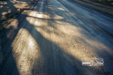
Photograph, Road construction operations, Shire of Eltham, c.1988, 1988c
Roll of 35mm colour negative film, 5 stripsFuji 100infrastructure, road construction, eltham shire council -
 Port Melbourne Historical & Preservation Society
Archive - File, Safer Routes to Shops in Port Melbourne, 2000 - 2001
This project involved community representatives in the identification of unsafe points on the route between Wintringham Hostel and Bay Street, in particular for elderly and disabled people. The intention of the project was to improve coordination between departments of Council viz. Health & Safety with Infrastructure. The lack of coordination that was a legacy of contracting-out was evident throughout the project.File of documents, reports, correspondence, photos relating to the project "Safer Routes to Shops in Port Melbourne" (between Wintringham Hostel and Bay Street) 2000-2001engineering - roads streets lanes and footpaths, matt rodda, jim hillis, perce mcguire white, perce white -
 Nillumbik Shire Council
Public Art: Helen BODYCOMB (b.1964, South Australia) and Enver CAMDAL (Lives and works Turkey), Enver Camdal et al, Nest (Location: Roundabout, Main and Luck Street, Eltham), 1997
Commissioned by Nillumbik Shire Council - 1997 The selection panel in the commissioning process to this 'extraordinary acquisition' was Rhonda Noble, Director of La Trobe University Museum of Art, Jeph Neale, Eltham Roundabout Advisory Group, Chris Marks, NSC Curator of Collections, Geoff Glynn, NSC Manager of Infrastructure Development.'Nest' highlights the indigenous flora and fauna of the Shire. The stiff, coarse grass used to create the nest is indigenous to the area and the eggs are like those of the spotted quail thrush, a ground-nesting bird of the Shire. The circular flow or placement of the eggs recalls the revolution of the seasons and nesting cycles. There is a tall light pole above the eggs, shining down at night. The effect is of a giant incubator. Enrichment and nurturing of the larger environment can be associated with this sculpture. This work resembles a large bird's nest, with three egg-like forms of fibreglass covered in a pebble render, set on sand. The nest is positioned within the paved boundary of the roundabout. The nest shape has been created out of stiff, coarse indigenous grass, periodically trimmed so the view is not obstructed. The eggs are a brown-speckled, creamy yellow colour. The three eggs are arranged in a ring, with the narrow end of each pointing to the large end of the next, in a circle that mimics the flow of traffic. N/Apublic art, nest, eggs, eltham, ekphrasis2017, mosaic, pebbles, roundabout, spotted quail thrush -
 Bendigo Historical Society Inc.
Document - LONG GULLY HISTORY GROUP COLLECTION: HISTORY OF THE FIELD (GOLD)
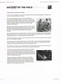
Three pages of History of the Field, A Brief History of Mining in Bendigo. The history starts in 1851 when gold was discovered along the Bendigo Creek to 1992 when Bendigo Mining NL purchased the licences and infrastructure from WMC. There are four small photos: Two men working a puddling machine; Victoria Hill - 1850's Open Cut; Victoria Hill Quartz Mine, and the Central Deborah Mine. There is also a web address in the top right corner.bendigo, history, long gully history group, the long gully history group - history of the field (gold), mrs margaret kennedy, mrs farrell, edward nucella emmett, cave and amos, victoria quartz, new chum railway, bendigo amalgamated gold mies, bendigo mines ltd, deborah mines, william burrell, wmc, williams united, charshalton, bendigo mining nl, new bendigo project, trevor clark, shelley saunders, peter wiseman, new bendigo - 10 million ounces of gold -
 Kew Historical Society Inc
Map, MMBW, River Yarra Beautification Schemes, c.1913
The Melbourne and Metropolitan Board of Works (MMBW) was established by an act of the Victorian Parliament in 1890 to prepare for and to implement a sewerage and water reticulation system across what was then inner Melbourne, its surrounding and middle distance suburbs, including Kew. The MMBW was disbanded in 1991.The map collection of the Kew Historical Society has at its core the historic maps assembled and originally stored in the City Engineer's Department of the City of Kew. These include maps in a number of scales. The vast majority of maps were produced by the MMBW in the first two decades of the twentieth century, and are solid working maps, backed by linen for durability. These maps are historically significant to Kew, the City of Boroondara and to the history of the development of state utilities in Victoria. A number of the Kew maps have additional details added by former municipal officers, including the levels reached by various floods. As these were working documents, information was added to them long after the period of their initial production and distribution.Map of the City of Kew showing part of the River Yarra Beautification Schemes. The map shows development to date and the flood levels reached in 1923 and 1924. This map may have been adapted from an earlier map, as most development in central Kew and Studley Park had occurred by this date yet numerous streets are not represented. Public buildings and institutions are clearly represented and named on the map as are significant public transport infrastructure (eg the Outer Circle railway).MELBOURNE AND METROPOLITAN BOARD OF WORKS / RIVER YARRA BEAUTIFICATION SCHEMES / SCHEME / SCALE 10 CHAINS TO AN INCHmelbourne & metropolitan board of works, mmbw maps, mmbw plans, city of kew, flood levels -- kew (vic.), cartography -
 Melbourne Tram Museum
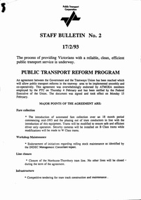
Document - Notice, The Met, Public Transport Corporation, "Staff Bulletin No. 2 - 17/2/93", 17/02/1993 12:00:00 AM
Notice - 3 A4 sheets stapled in the top left hand corner, titled "Staff Bulletin No. 2 - 17/2/93" - follows an agreement with the ATMOEA union, about fare collection, workshops, line closure (just Northcote to Thornbury), Infrastructure, service levels, retention of tram services, tendering of bus services, and various other reforms, consultation, arbitration hearings and revised interim management structure. Signed by John McMillan. See also 3049 and 3052trams, tramways, services, buses, bus replacement, tram replacement, railways, contracts, preston depot, met ticket, maintenance, unions, atmoea, agreements -
 Melbourne Tram Museum
Document, Public Transport Corporation (PTC), "Cars passing stationary trams", Jan 1992
Document or letter to the Director of Infrastructure Management (PTC) from the Manager of Protective Services about cars passing stationary trams. Dated 15/1/1992. Contains data, letter from the Chief Superintendent Transit Police, offences recorded, and outcomes. Originated from a 1991 memo from Manager Kew Depot. Yields information about the issue of motor cars passing stationary trams.Document or letter - 7 A4 sheets, stapled in top left hand corner - photocopied.ptc, tramways, kew depot, traffic control, police, motor cars -
 Melbourne Tram Museum
Document - Folder with papers, Newstead Tramcars, "For Sale - Newstead Tramcars - ex Melbourne X1 class tramcars", Dec. 2003
White folder with a "For Sale" sticker on the front containing the following documents/items" 1 - Business Cards for Daren Hutchesson and Len Millar 2 - Letter to Mike Ryan, Dept of Infrastructure forwarding the document and dated 8/12/2003 3 - CD with image of the tramcar and film of the tram in use. 4 - 13 full colour sheets providing details of the tramcar, specifications, floor plan, options, spare parts, details of Newstead Tramcars, History, terms of trade and photos of the rebuilding.trams, tramways, reports, newstead tramcars, x1 class, reconstruction, tram 466 -
 Kiewa Valley Historical Society
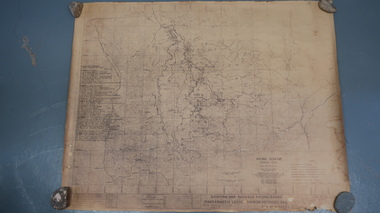
Map - Kiewa Scheme General Plan
Existing and possible future roads are numbered and named 1 - 45. The plan is based on an aerial photos taken March 1945. It includes revisions up to 1951. Signed by H.H.C. Williams, construction engineer. Mountains, rivers, roads and SECV places are named, also SECV infrastructure and construction eg. workers camps, Power stations.Significant for the information re the Kiewa Hydro Electric Scheme's development.Yellowed paper with brown print. Kiewa Scheme general plan showing its development. A lot of information is recorded. Note: Dyeline print was used which causes fading when exposed to light. Handwritten: 'Bob Duncan'bob duncan, kiewa hydro electric scheme, secv, khes development -
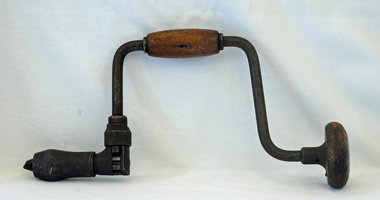
 Orbost & District Historical Society
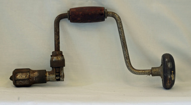
ratchet brace, first half 20th century
This carpenter's clamp would have been used in confined spaces where a full turn of the brace cannot be achieved. It is fitted with a pawl mechanism - a hinged or pivoted device adapted to fit into a notch of a ratchet wheel to impart forward motion or prevent backward motion. This item would have been used on a rural property in constructing or maintaining infrastructure.This item is an example of a woodworking tool used in the first half of the 20th century prior to the widespread use of power tools.A metal ratchet brace with a wooden handle grip. It has a hinged mechanism device which fits into the notches of the ratchet wheel - a pawl.woodwork tools brace-ratchet -
 Orbost & District Historical Society
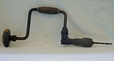
brace and bit, first half 20th century
This carpenter's clamp would have been used in confined spaces where a full turn of the brace cannot be achieved. It is fitted with a pawl mechanism - a hinged or pivoted device adapted to fit into a notch of a ratchet wheel to impart forward motion or prevent backward motion. This item would have been used on a rural property in constructing or maintaining infrastructure.This item is an example of a woodworking tool used in the first half of the 20th century prior to the widespread use of power tools.A metal ratchet brace with a wooden handle grip. It has a hinged mechanism device which fits into the notches of the ratchet wheel - a pawl. The drill bit is jammed and the chuck is rusted.woodworking tool brace-and-bit carpentry -
 Orbost & District Historical Society
ratchet brace, first half 20th century
This carpenter's clamp would have been used in confined spaces where a full turn of the brace cannot be achieved. It is fitted with a pawl mechanism - a hinged or pivoted device adapted to fit into a notch of a ratchet wheel to impart forward motion or prevent backward motion. This item would have been used on a rural property in constructing or maintaining infrastructure. This item is an example of a woodworking tool used in the first half of the 20th century prior to the widespread use of power tools. A metal ratchet brace with a wooden handle grip. It has a hinged mechanism device which fits into the notches of the ratchet wheel - a pawl -
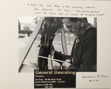 Kew Historical Society Inc
Photograph - Public Works Street Maintenance, Gellibrand Street, General Descaling, 1970
The series from which the photograph is drawn provides a snapshot by a commercial photographic studio of specific street works in Kew as well as providing examples of public works infrastructure being commissioned by local government in the 1970s. The photos originally formed part of the Engineering Department's files in the City of Kew before being donated to the Kew Historical Society.In addition to its historic importance as a record of a particular streetscape in Kew in 1970, the photograph also provides an historic record of public works by local government during the period.Public Works Street Maintenance, Gellibrand Street, Kew, Company supplied photograph of measuring a tree root in Gellibrand Street. Inscribed above photo: "A tough dry root from a tree previously removed from alongside the drain. The root development inside the barrel had not caused the brick work to split. Gellibrand St. Drain 24.4.70." Company information: "General Descaling / Company / 1st Floor 66-68 Albert Road/ South Melbourne 3205 Victoria / Telephone 699 1455 / 699 1635."general descaling, drains, gellibrand street (kew) -
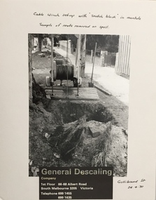 Kew Historical Society Inc
Photograph - Public Works Street Maintenance, Gellibrand Street, General Descaling, 1970
The series from which the photograph is drawn provides a snapshot by a commercial photographic studio of specific street works in Kew as well as providing examples of public works infrastructure being commissioned by local government in the 1970s. The photos originally formed part of the Engineering Department's files in the City of Kew before being donated to the Kew Historical Society.In addition to its historic importance as a record of a particular streetscape in Kew in 1970, the photograph also provides an historic record of public works by local government during the period.Public Works Street Maintenance, Gellibrand Street, Kew, Company supplied photograph of cable laying in Gellibrand Street. Inscribed above photo: "Boring through obstacles to pass cable. Cable extends from winch to cutting tool in both directions to permit a to and fro cutting motion. Gellibrand St. Drain 23.4.70." Company information: "General Descaling / Company / 1st Floor 66-68 Albert Road/ South Melbourne 3205 Victoria / Telephone 699 1455 / 699 1635."general descaling, drains, gellibrand street (kew) -
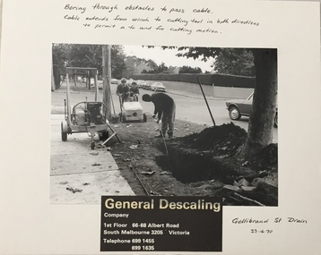 Kew Historical Society Inc
Photograph - Public Works Street Maintenance, Gellibrand Street, General Descaling, 1970
The series from which the photograph is drawn provides a snapshot by a commercial photographic studio of specific street works in Kew as well as providing examples of public works infrastructure being commissioned by local government in the 1970s. The photos originally formed part of the Engineering Department's files in the City of Kew before being donated to the Kew Historical Society.In addition to its historic importance as a record of a particular streetscape in Kew in 1970, the photograph also provides an historic record of public works by local government during the period.Public Works Street Maintenance, Gellibrand Street, Kew. Company supplied photograph of cable laying in Gellibrand Street. Inscribed above photo: "Boring through obstacles to pass cable. Cable extends from winch to cutting tool in both directions to permit a to and fro cutting motion. Gellibrand St. Drain 23.4.70." Company information: "General Descaling / Company / 1st Floor 66-68 Albert Road/ South Melbourne 3205 Victoria / Telephone 699 1455 / 699 1635."general descaling, drains, gellibrand street (kew) -
Melbourne Tram Museum
Document - Digital Image, Victorian Transport Action Group (VTAG), "Melbourne’s Tram Plan Response Filling the Gaps", March 2024
Document produced by the Victorian Transport Action Group as a response to the Department of Transport "Melbourne Tram Plan" of Oct. 2023 - see item 7364. VTAG have produced a number of initiatives and looks at a number of route proposals that have been made by Government but as of the end of 2024, little progress has been made on any of them. Initiatives suggested are: 1. Confirm its commitment to previously announced projects (listed in Table 1) and provide indicative timeframes for completion. 2. Redirect routes 3, 5 and 12 (detailed in Table 2) with the opening of MM1 to improve the distribution of tram services through the central area. 3. Direct Infrastructure Victoria to undertake the specific planning process as part of the next state infrastructure plan to canvas a range of possible network enhancements. 4. Revise the selection of stops for upgrade to level access to include the practical considerations of technical feasibility and constructability to ensure that as many stops as possible are delivered as a priority. 5. Expand the corridor-based approach being applied to upgrade stops to include the implementation of traffic priority along the selected corridors. 6. Adopt a 15mins, or at least 20 mins, as the maximum headway for all Melbourne tram routes. Notes changes that will be needed as a result of the Melbourne Metro in 2025, tram stops, energy efficiency, renewing the fleet and infrastructure, network performance, and passenger experience. Demonstrates a response to the Vic Govt's tram plan by an Action Group.Digital copy of a 21 A4 page document produced by the Victorian Transport Action Group March 2024. tramways, victorian government, department of transport, planning, vtag -
 Broadmeadows Historical Society & Museum
Photograph, Construction of Access Road, Banksia Gardens, c 1980s
This item depicts the construction of the Access Road to Banksia Gardens, The photograph captures a significant moment in the development of the Banksia Gardens housing project, highlighting the infrastructure improvements aimed at enhancing accessibility and connectivity within the community. The construction of the access road was a crucial step in the urban planning process, facilitating easier movement for residents and contributing to the overall development and integration of the housing estate.This item, showing the construction of the Access Road to Banksia Gardens, holds significant historical value. It documents a pivotal moment in the development of the Banksia Gardens housing project, illustrating the efforts to improve infrastructure and accessibility within the community. The construction of the access road was a key component in the urban planning strategy, aimed at enhancing connectivity and facilitating the movement of residents. This development not only improved the practical aspects of daily life for the community but also symbolised progress and growth within the housing estate. The photograph serves as an important record of the planning and development processes that shaped the Banksia Gardens community.Poor quality black and white photograph on matte photographic paper.banksia gardens, broadmeadows, construction, access road, c 1980's -
Melbourne Tram Museum
Newspaper, The Age, "Transport past gets $400,000 polish", 15/2/1995
Newspaper cutting from The Age, titled "Transport past gets $400,000 polish", about the expenditure on heritage transport infrastructure following a grant from Heritage Victoria. Includes the tramway poles in Dandenong Road, Peel St North Melbourne and railway station. Quotes Mr Brown, Transport Minister and Rohan Storey of the National Trust. Dated 15/2/1995.. Has a photo looking along Dandenong Road from an over bridge. Story by Bruce Tobin, Photo Michael Clayton-Jones.trams, tramways, overhead, heritage victoria, grants, poles, national trust -
 Melbourne Tram Museum
Document - Research Notes, "The development of Melbourne's trams - Part One", c1990
Six page A4 document, stapled in top left hand corner, titled "The development of Melbourne's trams - Part One". Document looks at the Melbourne cable tram system, its formation, George Duncan and Francis Clapp, leasing, passing to MMTB, the infrastructure and winding houses, the cable, opening dates, closure and lines in the Toorak area and depots. Author unknown, possible late 1990's. Two copies held. See also item 1762 for a publication with the same title, written by Keith Kings.trams, tramways, cable trams, mto co, mtt, mmtb, closure -
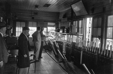 Eltham District Historical Society Inc
Photograph, George Coop, Newport Signal Box, Newport Railway Station, c.1951
Now demolished. Newport Railway station, visible through the windows was situated on the opposite side of the Melbourne Road level crossing. All of this infrastructure has since been replaced by a large overpass, the level crossing now the location of a pedestrain underpass. One of several photos at Newport taken the same day in the early 1950s when George Coop was a secondary school student.Digital TIFF file Scan of Kopdak 620 black and white negative transparencygeorge coop collection, newport railway station, level crossing, melbourne road, newport signal box -
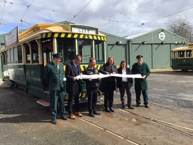 Ballarat Tramway Museum
Photograph - Opening of the new track, Patricia Cameron, 10-9-2022
Digital image by Patricia Cameron at the time of the launch or opening of the relaid or replaced track in Wendouree Parade and depot extension. Has Sam Boon, Cr Daniel Maloney, BTM President Paul Mong, Catherine King MP, Juliana Addison MP and Len Millar - standing in front of tram 13. Catherine King - Minister for Infrastructure, Transport, Regional Development and Local GovernmentProvides information on the people involved at the time of the launch of the new replaced trackwork.Digital Image of the cutting of the ribbon to open the new track - 10 September 2022 btm, trackwork, opening, launch, tram 13, museum, depot -
 Eltham District Historical Society Inc
Album - Photograph, J.A. McDonald, Eltham Swimming Pool, Dec. 1956
Eltham Swimming Pool December 1956Record of various Shire of Eltham infrastructure works undertaken during the period of 1952-1962 involving bridge and road reconstruction projects, sometimes with Eltham Shire Council Project Reference numbers quoted. It was during this period that a number of significant improvements were made to roads and new bridges constructed within the shire that remain in place as of present day (2022). In many situations, the photos provide a tangible visible record of infrastructure that existed throughout the early days of the Shire. The album was put together by or under the direction of the Shire Engineer, J.A. McDonald.infrastructure, shire of eltham, 1956-12, eltham swimming pool -
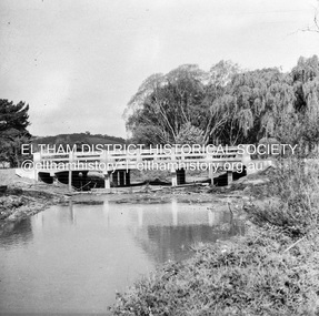
 Eltham District Historical Society Inc
Album - Photograph, J.A. McDonald, Eltham Swimming Pool, Nov. 1956
Eltham Swimming Pool Scum Gutter November 1956Record of various Shire of Eltham infrastructure works undertaken during the period of 1952-1962 involving bridge and road reconstruction projects, sometimes with Eltham Shire Council Project Reference numbers quoted. It was during this period that a number of significant improvements were made to roads and new bridges constructed within the shire that remain in place as of present day (2022). In many situations, the photos provide a tangible visible record of infrastructure that existed throughout the early days of the Shire. The album was put together by or under the direction of the Shire Engineer, J.A. McDonald.infrastructure, shire of eltham, eltham swimming pool, 1956-11 -
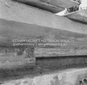
 Eltham District Historical Society Inc
Negative - Photograph, J.A. McDonald, Unidentified bridge, c.May 1958
Record of various Shire of Eltham infrastructure works undertaken during the period of 1952-1962 involving bridge and road reconstruction projects, sometimes with Eltham Shire Council Project Reference numbers quoted. It was during this period that a number of significant improvements were made to roads and new bridges constructed within the shire that remain in place as of present day (2022). In many situations, the photos provide a tangible visible record of infrastructure that existed throughout the early days of the Shire. The album was put together by or under the direction of the Shire Engineer, J.A. McDonald.infrastructure, shire of eltham, 1958-05, bridge construction -
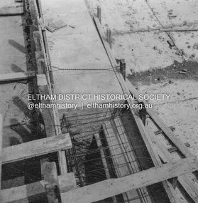
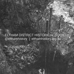 Eltham District Historical Society Inc
Negative - Photograph, J.A. McDonald, Unidentified bridge pier construction, June 1958
Record of various Shire of Eltham infrastructure works undertaken during the period of 1952-1962 involving bridge and road reconstruction projects, sometimes with Eltham Shire Council Project Reference numbers quoted. It was during this period that a number of significant improvements were made to roads and new bridges constructed within the shire that remain in place as of present day (2022). In many situations, the photos provide a tangible visible record of infrastructure that existed throughout the early days of the Shire. The album was put together by or under the direction of the Shire Engineer, J.A. McDonald.infrastructure, shire of eltham, 1958-06, bridge construction -
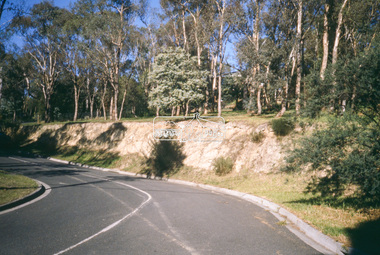
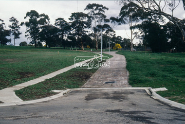
 Eltham District Historical Society Inc
Slide - Photograph, Unidentified location, Eltham district, c.May1990
35mm colour positive transparency (1 of 25) Mount - Kodak EktachromeProcessing Date Code Jun 90Mroads, infrastructure, shire of eltham, unidentified -
 Eltham District Historical Society Inc
Slide - Photograph, Unidentified location, Eltham district, c.May1990
35mm colour positive transparency (1 of 25) Mount - Kodak EktachromeProcessing Date Code Jun 90Mroads, infrastructure, shire of eltham, unidentified -
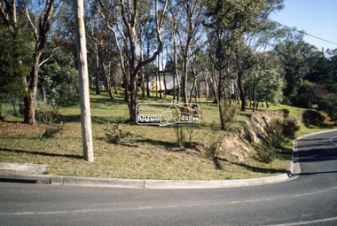
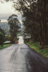 Eltham District Historical Society Inc
Slide - Photograph, Unidentified location, Eltham district, c.Aug. 1990
Part of a presentation, "Roads and Byways of the Shire of Eltham", by Russell Yeoman to the 12 September 1990 Society meeting. Slides shown included copies of old photos and recent images ranging from the suburban streets of Eltham and Montmorency to the mountain roads of Kinglake. In the byways category are views of some iof the Shire's bicycle paths including then recently completed sections of the Main Yarra Trail at Lower Plenty.35mm colour positive transparency (1 of 37) Mount - Agfachrome Agfa CS System black 8 dotseltham, infrastructure, roads, unidentified -
 Eltham District Historical Society Inc
Slide - Photograph, Unidentified location, Eltham district, c.Aug. 1990
Part of a presentation, "Roads and Byways of the Shire of Eltham", by Russell Yeoman to the 12 September 1990 Society meeting. Slides shown included copies of old photos and recent images ranging from the suburban streets of Eltham and Montmorency to the mountain roads of Kinglake. In the byways category are views of some iof the Shire's bicycle paths including then recently completed sections of the Main Yarra Trail at Lower Plenty.35mm colour positive transparency (1 of 37) Mount - Agfachrome Agfa CS System black 8 dotseltham, infrastructure, roads, unidentified