Showing 654 items
matching kew- cotham road
-
 Kew Historical Society Inc
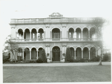
Photograph - 'Ross House' (formerly 'Charleville'), 292 Cotham Road, Progress Press, 1978
... houses --- Cotham Road -- kew (Vic.)... --- Cotham Road -- kew (Vic.) mansions -- kew (Vic.) Photographic ...Ross House, formerly called Charleville, was built as a two-storey mansion in 1889 for Charles Donaldson. It was designed in the Italianate style by the architect H. Shallers and built by G. Ginham. Dr Tom King, surgeon purchased Charleville from Donaldson in 1939 and renamed it Ross House.Photographic print positive of 'Ross House' (formerly 'Charleville'), Cotham Roadross house, charleville, houses --- cotham road -- kew (vic.), mansions -- kew (vic.) -
 Kew Historical Society Inc
Journal, Kewriosity : March 1991
Kew Festival 10th March to 24th March - Kew is for living / artwork Heike Effler / p1. Dates for March [1991] / p2. Easter hours [Council Offices] / 2. 10th April [Rates and dog registrations due] / p2. Voters' Roll / p2. [Kew] Community House events / p2. Commentary / Cr Daryl Oldaker p3. Council's casino letter [Willsmere] / p3. Later to the editor [Casino] / E Stanley Meyer p3. Information: your view [Council survey] / p2. Cotham Road rebuilt [reconstruction] / p4. Anybody home? [1991 Census] / p4. Valley views protected [development along the Yarra River] / p4. Reaching the tram [upgrades] / p5. Traffic management update [Area 4, Area 5, Area 6, Area 7, Area 10] / p5. 7,000 more Kewites [projected population growth] / p5. New school buildings [Ruyton Girls' School; Methodist Ladies' College; Trinity Grammar; Xavier College; Genazzano College; Carey Grammar School; Preshil] / p5. High St [Pedestrian] Crossing / p5. St George's amalgamated [with Victoria Parade Geriatric Centre, Henry Pride Unit, Hawthorn Day Hospital] / p6. Youth co-ordination [Youth Workers' Forum] / p6. Bowling vacancies [East Kew Bowling Club] / p6. Driver wanted [for Henry Pride Geriatric Centre] / p6. On World's rooftop [Trinity Grammar students and teachers in Nepal] / p6. Trinity Day / p6. Clergy move / p6. Bus volunteers [needed for Kew Community Bus] / p6. Festival artist [Heike Effler] / p7. Citizens honoured [Australia Day honours] / p7. Medallion award [Royal Guide Dogs Association] / p7. Will bunny arrive? [Three and Fours Kindergarten] / p8. Fun with your children [Highbury Grove Playgroup] / p8. 2nd birthday celebrations [Kew Recreation Centre] / p8. Free electrolysis / p8. Empress of Britain [1938 voyage] / p8. Japanese woodblocks [exhibition at East West Art] / p8. Join the cast [Viola Musical Comedy Society]Kewriosity was a local newsletter combining Kew Council and community news. It was published between November 1983 and June 1994, replacing an earlier Kewriosity [broad] Sheet (1979-84). In producing Kewriosity, Council aimed to provide a range of interesting and informative articles covering its deliberations and decision making, together with items of general interest and importance to the Kew community and information not generally available through daily media outlets.non-fictionKew Festival 10th March to 24th March - Kew is for living / artwork Heike Effler / p1. Dates for March [1991] / p2. Easter hours [Council Offices] / 2. 10th April [Rates and dog registrations due] / p2. Voters' Roll / p2. [Kew] Community House events / p2. Commentary / Cr Daryl Oldaker p3. Council's casino letter [Willsmere] / p3. Later to the editor [Casino] / E Stanley Meyer p3. Information: your view [Council survey] / p2. Cotham Road rebuilt [reconstruction] / p4. Anybody home? [1991 Census] / p4. Valley views protected [development along the Yarra River] / p4. Reaching the tram [upgrades] / p5. Traffic management update [Area 4, Area 5, Area 6, Area 7, Area 10] / p5. 7,000 more Kewites [projected population growth] / p5. New school buildings [Ruyton Girls' School; Methodist Ladies' College; Trinity Grammar; Xavier College; Genazzano College; Carey Grammar School; Preshil] / p5. High St [Pedestrian] Crossing / p5. St George's amalgamated [with Victoria Parade Geriatric Centre, Henry Pride Unit, Hawthorn Day Hospital] / p6. Youth co-ordination [Youth Workers' Forum] / p6. Bowling vacancies [East Kew Bowling Club] / p6. Driver wanted [for Henry Pride Geriatric Centre] / p6. On World's rooftop [Trinity Grammar students and teachers in Nepal] / p6. Trinity Day / p6. Clergy move / p6. Bus volunteers [needed for Kew Community Bus] / p6. Festival artist [Heike Effler] / p7. Citizens honoured [Australia Day honours] / p7. Medallion award [Royal Guide Dogs Association] / p7. Will bunny arrive? [Three and Fours Kindergarten] / p8. Fun with your children [Highbury Grove Playgroup] / p8. 2nd birthday celebrations [Kew Recreation Centre] / p8. Free electrolysis / p8. Empress of Britain [1938 voyage] / p8. Japanese woodblocks [exhibition at East West Art] / p8. Join the cast [Viola Musical Comedy Society]publications -- city of kew (vic.), kewriosity, council newsletters, community newsletters -
Kew Historical Society Inc
Journal, Kewriosity : April 1989
Meals [on Wheels] well appreciated / p1 Report on East Kew "overdevelopment" / p1. Dates for April / p2. Commentary [civic awards, volunteers] / Cr Allen Martin / p3. Kew's nod to power line suggestion / p3. New Councillor [Cr Tom Indovino, Cr Joe Ormando, profiles] / p3. Cotham Road reconstructed [Streetscaping Master Plan] / p3. Traffic Management updates / p4. Ivy's number one [Ivy Smith, Kew Recreation Centre] / p4. In for a penny ... [dog pound] / p4. ... Bad times just around the corner [Kew City Library] / p4. Residents form action group [Cotham Residents’ Action Group] / p4. As Ruyton likes it ["As You Like It"] / p5. MLC fair sounds fun / p5. Students look for accommodation / p5. Asthma Swim classes here [Kew Recreation Centre] / p5. Watch your car [Neighbourhood Watch] / p6. Watch my lips [lip reading classes] / p6. Watch the birdie [Red Cross tour] / p6. Watch the meeting [Kew Community Action Group] / p6. Watch this space / p6. Playgroup binds young and old [Carnsworth-Garoopna Nursing Home] / p6. Baptist re-union / p6. School's 75th [The School for the Burwood Boys' Home, Wattle Park Primary School] / p6. What's the point in baby-sitting [Boroondara Babysitting Club] / p7. Heritage Week [Willsmere, Kew Historical Society] / p7. Bodalla Garden Party / p7. Youthful fitness [Little Athletics] / p7. Keeping you informed [Citizens Advice Bureau] / p8. Tram dream / p8. Hefty competition [weightlifting] / p8. [Kew Citizens'] Band competes at Ipswich / p8. Join the Chorus [Viola Musical Comedy Society ] / p8. Non-stop chamber music for Kew [Elysium Ensemble] / p8.Kewriosity was a local newsletter combining Kew Council and community news. It was published between November 1983 and June 1994, replacing an earlier Kewriosity [broad] Sheet (1979-84). In producing Kewriosity, Council aimed to provide a range of interesting and informative articles covering its deliberations and decision making, together with items of general interest and importance to the Kew community and information not generally available through daily media outlets.non-fictionMeals [on Wheels] well appreciated / p1 Report on East Kew "overdevelopment" / p1. Dates for April / p2. Commentary [civic awards, volunteers] / Cr Allen Martin / p3. Kew's nod to power line suggestion / p3. New Councillor [Cr Tom Indovino, Cr Joe Ormando, profiles] / p3. Cotham Road reconstructed [Streetscaping Master Plan] / p3. Traffic Management updates / p4. Ivy's number one [Ivy Smith, Kew Recreation Centre] / p4. In for a penny ... [dog pound] / p4. ... Bad times just around the corner [Kew City Library] / p4. Residents form action group [Cotham Residents’ Action Group] / p4. As Ruyton likes it ["As You Like It"] / p5. MLC fair sounds fun / p5. Students look for accommodation / p5. Asthma Swim classes here [Kew Recreation Centre] / p5. Watch your car [Neighbourhood Watch] / p6. Watch my lips [lip reading classes] / p6. Watch the birdie [Red Cross tour] / p6. Watch the meeting [Kew Community Action Group] / p6. Watch this space / p6. Playgroup binds young and old [Carnsworth-Garoopna Nursing Home] / p6. Baptist re-union / p6. School's 75th [The School for the Burwood Boys' Home, Wattle Park Primary School] / p6. What's the point in baby-sitting [Boroondara Babysitting Club] / p7. Heritage Week [Willsmere, Kew Historical Society] / p7. Bodalla Garden Party / p7. Youthful fitness [Little Athletics] / p7. Keeping you informed [Citizens Advice Bureau] / p8. Tram dream / p8. Hefty competition [weightlifting] / p8. [Kew Citizens'] Band competes at Ipswich / p8. Join the Chorus [Viola Musical Comedy Society ] / p8. Non-stop chamber music for Kew [Elysium Ensemble] / p8. publications -- city of kew (vic.), kewriosity, council newsletters, community newsletters -
Kew Historical Society Inc
Journal, Kew Historical Society, Newsletter No.101, December 2012
Reaching out to the community [President's Report, 2012 AGM] / David Benwell p1-2. Society Activities - History Week; A visit to Kew Primary School; Past meetings / p3. From the archives / Dorothy Benyei p4. Lost and wanted [Mooroolbeek; Clutha] / p4. Gallipoli and beyond: April 2015 / Alex Wilson OAM p5. The mystery of Barkers Track / Alex Wilson OAM p6. Eleanor Haidee Simeon c.1822-1910 / Robert Baker p7-8. 'Malinda' [aka 'Bella Vista', 276 Cotham Road] / Dione McIntyre p9. The baby grand [Just Theatre] / Judith Vimpani / p10. Kew Court House / p10. History and heritage online [ websites] / Robert Baker p11. 2012-13 Calendar / p12.Published quarterly since 1977, the newsletters of the Kew Historical Society contain significant research by members exploring relevant aspects of the Victorian and Australian Framework of Historical Themes. Frequently, articles on people, places and artefacts are the only source of information about an aspect of Kew, and Melbourne’s history.non-fictionReaching out to the community [President's Report, 2012 AGM] / David Benwell p1-2. Society Activities - History Week; A visit to Kew Primary School; Past meetings / p3. From the archives / Dorothy Benyei p4. Lost and wanted [Mooroolbeek; Clutha] / p4. Gallipoli and beyond: April 2015 / Alex Wilson OAM p5. The mystery of Barkers Track / Alex Wilson OAM p6. Eleanor Haidee Simeon c.1822-1910 / Robert Baker p7-8. 'Malinda' [aka 'Bella Vista', 276 Cotham Road] / Dione McIntyre p9. The baby grand [Just Theatre] / Judith Vimpani / p10. Kew Court House / p10. History and heritage online [ websites] / Robert Baker p11. 2012-13 Calendar / p12. kew historical society (vic.) -- periodicals., kew historical society (vic.) -- newsletters, kew historical society (vic.) -- journals -
Kew Historical Society Inc
Journal, Kewriosity : November 1983
High Street/Cotham Road intersection / p1. Traffic Management Study - Area 6 / p1. Kew Council elections / p1. Not an elephant joke [community newspapers] / p2. Kew–Hathorn C.A.B. [Citizens' Advice Bureau] / p3. Family trees [Genealogy] / p3. Little Aths / p3. Kew Hebrew Congregation / p3. Asthma Education / p4. A place of shades [Boroondara General (Kew) Cemetery] / Barbara Giles p4. More than a school [Villa Maria Society; St Paul's School for the Blind and Visually Handicapped] / p5. Who is she? [Community Education Officer - Nancy Nankervis] / p6. Toastmasters - who are they? / p6. Art classes [Donald Cameron] / p6. Fundraising [St Paul's Church Hall] / p6. Kew Cricket underway [Kew Cricket Club] / p7. Kew Baptist Church / p7. Coming events / p8.Kewriosity was a local newsletter combining Kew Council and community news. It was published between November 1983 and June 1994, replacing an earlier Kewriosity [broad] Sheet (1979-84). In producing Kewriosity, Council aimed to provide a range of interesting and informative articles covering its deliberations and decision making, together with items of general interest and importance to the Kew community and information not generally available through daily media outlets.non-fictionHigh Street/Cotham Road intersection / p1. Traffic Management Study - Area 6 / p1. Kew Council elections / p1. Not an elephant joke [community newspapers] / p2. Kew–Hathorn C.A.B. [Citizens' Advice Bureau] / p3. Family trees [Genealogy] / p3. Little Aths / p3. Kew Hebrew Congregation / p3. Asthma Education / p4. A place of shades [Boroondara General (Kew) Cemetery] / Barbara Giles p4. More than a school [Villa Maria Society; St Paul's School for the Blind and Visually Handicapped] / p5. Who is she? [Community Education Officer - Nancy Nankervis] / p6. Toastmasters - who are they? / p6. Art classes [Donald Cameron] / p6. Fundraising [St Paul's Church Hall] / p6. Kew Cricket underway [Kew Cricket Club] / p7. Kew Baptist Church / p7. Coming events / p8. publications -- city of kew (vic.), kewriosity, council newsletters, community newsletters -
 Kew Historical Society Inc
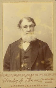
Photograph - John Padbury
... businesses -- Cotham Road -- Kew (Vic.)... businesses -- Cotham Road -- Kew (Vic.) Obverse: “Frisby & Mason ...Padbury’s Funeral Parlour in Kew was the earliest business of its kind in what is now the City of Boroondara. It was established by John Padbury in 1859. Following his death, the company was renamed A W Padbury & Co. John Padbury was involved in meetings in 1861, calling for Kew to become an independent municipality. In 1863, he argued that a lunatic asylum would bring business to shopkeepers. His company was located at 13 Cotham Road, next to the rear entrance of the Kew Police Station. The two-storey building is still [in 2023] extant. Members of the Padbury family married into a number of pioneer Kew families including the Whitmans and Morgans. Rare portrait of a significant Kew pioneerOriginal print positive 'cabinet card'. Portrait of John Padbury, first undertaker in Boroondara. Obverse: “Frisby & Mason / Photographers / 134 Bridge Road Richmond”. Reverse: “John Padbury / founder of Padbury Undertakers Cotham Rd Kew / died 90 yrs / Whitman”funeral parlours. -- kew (vic.), a w padbury, john padbury, businesses -- cotham road -- kew (vic.) -
 Kew Historical Society Inc
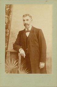
Photograph - Alfred Padbury, W Mason
... businesses -- Cotham Road -- Kew (Vic.).... -- Kew (Vic.) a w padbury businesses -- Cotham Road -- Kew (Vic ...Padbury’s Funeral Parlour in Kew was the earliest business of its kind in what is now the City of Boroondara. It was established by John Padbury in 1859. Following his death, the company was renamed A W Padbury & Co. The two-storey building is still [in 2023] extant. Members of the Padbury family married into a number of pioneer Kew families including the Whitmans and Morgans. Rare portrait of a significant Kew businessmanOriginal print positive 'cabinet card'. Portrait of Alfred Padbury, owner of A W Padbury & Co. Son of founder - John Padbury.Reverse: “Alfred Padbury / Son of John Padbury / Whitman”funeral parlours. -- kew (vic.), a w padbury, businesses -- cotham road -- kew (vic.) -
 Kew Historical Society Inc
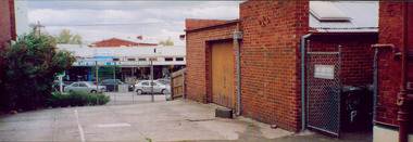
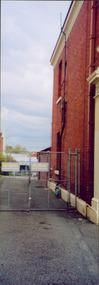
Photograph - Former Kew Police Station : Parking lot, 1996
A civic campaign for new public offices developed in Kew in the 1880s. After much deliberation, the location chosen was the junction of Bulleen and Cotham Roads. The buildings were designed by George Watson and John Henry Harvey, architects within the Department of Public Works (Victoria). Building was commenced in 1887, and after one year, the buildings were opened. The Post Office was transferred to the new Commonwealth Government in 1901. The Police Station and Court House, sold by the Victorian Government to the City of Boroondara in 2007, are now a community cultural centre and performing arts venue.The buildings were listed on the Victorian Heritage Register Register (HO885) in 1991. They are historically and architecturally significant to the State of Victoria because Watson and Harvey's designs exhibit diversity in integrating civil offices, they accommodate the apex of road junctions, and they demonstrate a departure from the contemporaneously favoured High Victorian Classical to the Queen Anne style in the design of civic buildings.View through the old wire gates into the parking lot behind the former Kew Police Station and Court House. This was the entrance from Cotham Road with which supplies, prisoners, and police cars would enter.kew court house, public offices -- kew (vic), kew police station -
 Kew Historical Society Inc
Photograph - Former Kew Court House : Court Room, 1996
A civic campaign for new public offices developed in Kew in the 1880s. After much deliberation, the location chosen was the junction of Bulleen and Cotham Roads. The buildings were designed by George Watson and John Henry Harvey, architects within the Department of Public Works (Victoria). Building was commenced in 1887, and after one year, the buildings were opened. The Post Office was transferred to the new Commonwealth Government in 1901. The Police Station and Court House, sold by the Victorian Government to the City of Boroondara in 2007, are now a community cultural centre and performing arts venue.The buildings were listed on the Victorian Heritage Register Register (HO885) in 1991. They are historically and architecturally significant to the State of Victoria because Watson and Harvey's designs exhibit diversity in integrating civil offices, they accommodate the apex of road junctions, and they demonstrate a departure from the contemporaneously favoured High Victorian Classical to the Queen Anne style in the design of civic buildings.Former court room of the Kew Court House. By 1993 when this photograph was taken, the room had been taken over by the Kew Police Station and used for police lockers and as a briefing room. In the foreground the edge of the magistrates' desk can be seen and in the distance the railing used to separate the public gallery from the main section of the court. This railing was repositioned to the foyer during the renovations of the Court House from 2007-11. The magistrates' desk was destroyed. kew court house, public offices -- kew (vic), kew police station -
 Kew Historical Society Inc
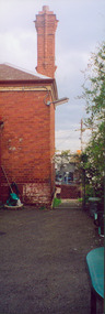
Photograph - Former Kew Police Station : Wall and chimney, 1996
A civic campaign for new public offices developed in Kew in the 1880s. After much deliberation, the location chosen was the junction of Bulleen and Cotham Roads. The buildings were designed by George Watson and John Henry Harvey, architects within the Department of Public Works (Victoria). Building was commenced in 1887, and after one year, the buildings were opened. The Post Office was transferred to the new Commonwealth Government in 1901. The Police Station and Court House, sold by the Victorian Government to the City of Boroondara in 2007, are now a community cultural centre and performing arts venue.The buildings were listed on the Victorian Heritage Register Register (HO885) in 1991. They are historically and architecturally significant to the State of Victoria because Watson and Harvey's designs exhibit diversity in integrating civil offices, they accommodate the apex of road junctions, and they demonstrate a departure from the contemporaneously favoured High Victorian Classical to the Queen Anne style in the design of civic buildings.View through the Cotham Road carpark towards High Street of the southeast corner of the former police station. The use of red brick, tall brick chimneys and slate roof were representative of the Queen Ann Style used in the construction of the Kew Public Offices in 1888.public offices -- kew (vic), kew police station -
 Kew Historical Society Inc
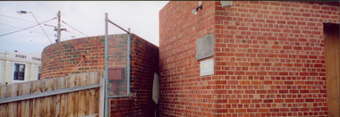
Photograph - Former Kew Court House : Outbuildings, 1996
A civic campaign for new public offices developed in Kew in the 1880s. After much deliberation, the location chosen was the junction of Bulleen and Cotham Roads. The buildings were designed by George Watson and John Henry Harvey, architects within the Department of Public Works (Victoria). Building was commenced in 1887, and after one year, the buildings were opened. The Post Office was transferred to the new Commonwealth Government in 1901. The Police Station and Court House, sold by the Victorian Government to the City of Boroondara in 2007, are now a community cultural centre and performing arts venue.The buildings were listed on the Victorian Heritage Register Register (HO885) in 1991. They are historically and architecturally significant to the State of Victoria because Watson and Harvey's designs exhibit diversity in integrating civil offices, they accommodate the apex of road junctions, and they demonstrate a departure from the contemporaneously favoured High Victorian Classical to the Queen Anne style in the design of civic buildings.View of old weatherboard outbuildings, including a toilet, constructed in the formerly open area behind the Post Office, Court House and Police Station. In the distance is a wall of the former Post Office.kew court house, public offices -- kew (vic), kew police station, kew post office -
 Kew Historical Society Inc
Photograph - Former Kew Post Office : Exterior wall, 1996
... Side wall, facing Cotham Road of the former Kew Post Office... kew post office Side wall, facing Cotham Road of the former ...A civic campaign for new public offices developed in Kew in the 1880s. After much deliberation, the location chosen was the junction of Bulleen and Cotham Roads. The buildings were designed by George Watson and John Henry Harvey, architects within the Department of Public Works (Victoria). Building was commenced in 1887, and after one year, the buildings were opened. The Post Office was transferred to the new Commonwealth Government in 1901. The Police Station and Court House, sold by the Victorian Government to the City of Boroondara in 2007, are now a community cultural centre and performing arts venue.The buildings were listed on the Victorian Heritage Register Register (HO885) in 1991. They are historically and architecturally significant to the State of Victoria because Watson and Harvey's designs exhibit diversity in integrating civil offices, they accommodate the apex of road junctions, and they demonstrate a departure from the contemporaneously favoured High Victorian Classical to the Queen Anne style in the design of civic buildings.Side wall, facing Cotham Road of the former Kew Post Officekew court house, public offices -- kew (vic), kew police station, kew post office -
 Kew Historical Society Inc
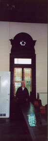
Photograph - Former Kew Court House : Window in Court Room, 1996
A civic campaign for new public offices developed in Kew in the 1880s. After much deliberation, the location chosen was the junction of Bulleen and Cotham Roads. The buildings were designed by George Watson and John Henry Harvey, architects within the Department of Public Works (Victoria). Building was commenced in 1887, and after one year, the buildings were opened. The Post Office was transferred to the new Commonwealth Government in 1901. The Police Station and Court House, sold by the Victorian Government to the City of Boroondara in 2007, are now a community cultural centre and performing arts venue.The buildings were listed on the Victorian Heritage Register Register (HO885) in 1991. They are historically and architecturally significant to the State of Victoria because Watson and Harvey's designs exhibit diversity in integrating civil offices, they accommodate the apex of road junctions, and they demonstrate a departure from the contemporaneously favoured High Victorian Classical to the Queen Anne style in the design of civic buildings.Dione McIntyre, Kew architect and member of Kew Historical Society, standing in front of a window in the former court room of the Kew Court House.kew court house, public offices -- kew (vic), kew police station -
 Kew Historical Society Inc
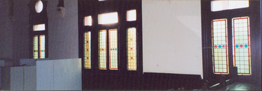
Photograph - Former Kew Court House : Windows in Court Room, 1996
A civic campaign for new public offices developed in Kew in the 1880s. After much deliberation, the location chosen was the junction of Bulleen and Cotham Roads. The buildings were designed by George Watson and John Henry Harvey, architects within the Department of Public Works (Victoria). Building was commenced in 1887, and after one year, the buildings were opened. The Post Office was transferred to the new Commonwealth Government in 1901. The Police Station and Court House, sold by the Victorian Government to the City of Boroondara in 2007, are now a community cultural centre and performing arts venue.The buildings were listed on the Victorian Heritage Register Register (HO885) in 1991. They are historically and architecturally significant to the State of Victoria because Watson and Harvey's designs exhibit diversity in integrating civil offices, they accommodate the apex of road junctions, and they demonstrate a departure from the contemporaneously favoured High Victorian Classical to the Queen Anne style in the design of civic buildings.Photograph of tall leadlight windows in the former Court Room (now the Just Theatre) of the Kew Court House. The photograph in the lower right corner shows part of the magistrates bench (now removed). Other items in the room include police lockers, as at that stage, in 1996, the room was occupied by the Kew Police Station and used as a briefing room and locker room.kew court house, public offices -- kew (vic.), court room -- victoria, kew police station -
 Kew Historical Society Inc
Photograph - Former Kew Court House : Outbuildings, 1996
A civic campaign for new public offices developed in Kew in the 1880s. After much deliberation, the location chosen was the junction of Bulleen and Cotham Roads. The buildings were designed by George Watson and John Henry Harvey, architects within the Department of Public Works (Victoria). Building was commenced in 1887, and after one year, the buildings were opened. The Post Office was transferred to the new Commonwealth Government in 1901. The Police Station and Court House, sold by the Victorian Government to the City of Boroondara in 2007, are now a community cultural centre and performing arts venue.The buildings were listed on the Victorian Heritage Register Register (HO885) in 1991. They are historically and architecturally significant to the State of Victoria because Watson and Harvey's designs exhibit diversity in integrating civil offices, they accommodate the apex of road junctions, and they demonstrate a departure from the contemporaneously favoured High Victorian Classical to the Queen Anne style in the design of civic buildings.Photograph of the rear of the former Kew Post Office, Court House, and Police Station showing outbuildings constructed within the formerly open court yard. These were service buildings for the workers in the Police Station.kew court house, public offices -- kew (vic), kew police station, kew post office -
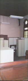
 Kew Historical Society Inc
Photograph - Former Kew Court House : Court Room, 1996
A civic campaign for new public offices developed in Kew in the 1880s. After much deliberation, the location chosen was the junction of Bulleen and Cotham Roads. The buildings were designed by George Watson and John Henry Harvey, architects within the Department of Public Works (Victoria). Building was commenced in 1887, and after one year, the buildings were opened. The Post Office was transferred to the new Commonwealth Government in 1901. The Police Station and Court House, sold by the Victorian Government to the City of Boroondara in 2007, are now a community cultural centre and performing arts venue.The buildings were listed on the Victorian Heritage Register Register (HO885) in 1991. They are historically and architecturally significant to the State of Victoria because Watson and Harvey's designs exhibit diversity in integrating civil offices, they accommodate the apex of road junctions, and they demonstrate a departure from the contemporaneously favoured High Victorian Classical to the Queen Anne style in the design of civic buildings.View of south wall of the former Kew Court House, which when the photo was taken had been converted into a section of the Kew Police Station, and used as a briefing and locker room.kew court house, kew police station -- high street -- kew (vic.), public offices -- kew (vic) -
 Kew Historical Society Inc
Photograph - Former Kew Court House : Court Room, 1996
A civic campaign for new public offices developed in Kew in the 1880s. After much deliberation, the location chosen was the junction of Bulleen and Cotham Roads. The buildings were designed by George Watson and John Henry Harvey, architects within the Department of Public Works (Victoria). Building was commenced in 1887, and after one year, the buildings were opened. The Post Office was transferred to the new Commonwealth Government in 1901. The Police Station and Court House, sold by the Victorian Government to the City of Boroondara in 2007, are now a community cultural centre and performing arts venue.The buildings were listed on the Victorian Heritage Register Register (HO885) in 1991. They are historically and architecturally significant to the State of Victoria because Watson and Harvey's designs exhibit diversity in integrating civil offices, they accommodate the apex of road junctions, and they demonstrate a departure from the contemporaneously favoured High Victorian Classical to the Queen Anne style in the design of civic buildings.View of south wall of the former Kew Court House, which when the photo was taken had been converted into a section of the Kew Police Station, and used as a briefing and locker room.Nilkew court house, court room -- victoria, public office - kew (vic.) -
 Kew Historical Society Inc
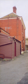
Photograph - Former Kew Police Station : Carpark, 1996
A civic campaign for new public offices developed in Kew in the 1880s. After much deliberation, the location chosen was the junction of Bulleen and Cotham Roads. The buildings were designed by George Watson and John Henry Harvey, architects within the Department of Public Works (Victoria). Building was commenced in 1887, and after one year, the buildings were opened. The Post Office was transferred to the new Commonwealth Government in 1901. The Police Station and Court House, sold by the Victorian Government to the City of Boroondara in 2007, are now a community cultural centre and performing arts venue.The buildings were listed on the Victorian Heritage Register Register (HO885) in 1991. They are historically and architecturally significant to the State of Victoria because Watson and Harvey's designs exhibit diversity in integrating civil offices, they accommodate the apex of road junctions, and they demonstrate a departure from the contemporaneously favoured High Victorian Classical to the Queen Anne style in the design of civic buildings.View of the carpark at the rear of the Kew Police Station which faces Cotham Road. The garage is a twentieth century addition.Nilkew police station, kew court house, public office - kew (vic.) -
 Kew Historical Society Inc
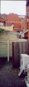
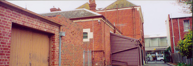
Photograph - Former Kew Police Station : outbuildings, 1996
A civic campaign for new public offices developed in Kew in the 1880s. After much deliberation, the location chosen was the junction of Bulleen and Cotham Roads. The buildings were designed by George Watson and John Henry Harvey, architects within the Department of Public Works (Victoria). Building was commenced in 1887, and after one year, the buildings were opened. The Post Office was transferred to the new Commonwealth Government in 1901. The Police Station and Court House, sold by the Victorian Government to the City of Boroondara in 2007, are now a community cultural centre and performing arts venue.The buildings were listed on the Victorian Heritage Register Register (HO885) in 1991. They are historically and architecturally significant to the State of Victoria because Watson and Harvey's designs exhibit diversity in integrating civil offices, they accommodate the apex of road junctions, and they demonstrate a departure from the contemporaneously favoured High Victorian Classical to the Queen Anne style in the design of civic buildings.View of the rear of the former Kew Police Station in High Street, Kew. In the foreground is a red brick garage; a later addition to the building. Immediately behind that is the back of the cell block. The two storey building facing High Street was originally the Police Sergeant's residence. public offices -- kew (vic.), kew police station -
 Kew Historical Society Inc
Photograph - Former Kew Court House : rear buildings facing Cotham Road, 1996
A civic campaign for new public offices developed in Kew in the 1880s. After much deliberation, the location chosen was the junction of Bulleen and Cotham Roads. The buildings were designed by George Watson and John Henry Harvey, architects within the Department of Public Works (Victoria). Building was commenced in 1887, and after one year, the buildings were opened. The Post Office was transferred to the new Commonwealth Government in 1901. The Police Station and Court House, sold by the Victorian Government to the City of Boroondara in 2007, are now a community cultural centre and performing arts venue.The buildings were listed on the Victorian Heritage Register Register (HO885) in 1991. They are historically and architecturally significant to the State of Victoria because Watson and Harvey's designs exhibit diversity in integrating civil offices, they accommodate the apex of road junctions, and they demonstrate a departure from the contemporaneously favoured High Victorian Classical to the Queen Anne style in the design of civic buildings.Original print positive photograph of two buildings on Cotham Road at the rear of the Kew Court House. On the left is a red brick public toilet block, designed by Roland Chipperfield. On the right is a red brick garage; a later addition to the Court House complex.kew court house, public offices -- kew (vic), public toilet -- kew (vic.), kew police station -
 Kew Historical Society Inc
Photograph - Former Kew Police Station : rear of building, 1996
A civic campaign for new public offices developed in Kew in the 1880s. After much deliberation, the location chosen was the junction of Bulleen and Cotham Roads. The buildings were designed by George Watson and John Henry Harvey, architects within the Department of Public Works (Victoria). Building was commenced in 1887, and after one year, the buildings were opened. The Post Office was transferred to the new Commonwealth Government in 1901. The Police Station and Court House, sold by the Victorian Government to the City of Boroondara in 2007, are now a community cultural centre and performing arts venue.The buildings were listed on the Victorian Heritage Register Register (HO885) in 1991. They are historically and architecturally significant to the State of Victoria because Watson and Harvey's designs exhibit diversity in integrating civil offices, they accommodate the apex of road junctions, and they demonstrate a departure from the contemporaneously favoured High Victorian Classical to the Queen Anne style in the design of civic buildings.Colour print positive photograph of the rear of the Kew Police Station before its acquisition by the City of Boroondara. The wooden addition was demolished at the time of the renovation.kew court house, public offices -- kew (vic), kew police station -
 Kew Historical Society Inc
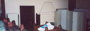
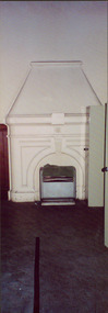
Photograph - Former Kew Court House : Court Room fireplace, 1996
A civic campaign for new public offices developed in Kew in the 1880s. After much deliberation, the location chosen was the junction of Bulleen and Cotham Roads. The buildings were designed by George Watson and John Henry Harvey, architects within the Department of Public Works (Victoria). Building was commenced in 1887, and after one year, the buildings were opened. The Post Office was transferred to the new Commonwealth Government in 1901. The Police Station and Court House, sold by the Victorian Government to the City of Boroondara in 2007, are now a community cultural centre and performing arts venue.The buildings were listed on the Victorian Heritage Register Register (HO885) in 1991. They are historically and architecturally significant to the State of Victoria because Watson and Harvey's designs exhibit diversity in integrating civil offices, they accommodate the apex of road junctions, and they demonstrate a departure from the contemporaneously favoured High Victorian Classical to the Queen Anne style in the design of civic buildings.The sole means of heating the Court Room of the former Kew Court House was this open fire place (now no longer useable). The fireplace was located on the south wall of the Court Room.kew court house, public offices -- kew (vic), court houses -- victoria -
 Kew Historical Society Inc
Photograph - Former Kew Police Station : East facing facade, 1996
A civic campaign for new public offices developed in Kew in the 1880s. After much deliberation, the location chosen was the junction of Bulleen and Cotham Roads. The buildings were designed by George Watson and John Henry Harvey, architects within the Department of Public Works (Victoria). Building was commenced in 1887, and after one year, the buildings were opened. The Post Office was transferred to the new Commonwealth Government in 1901. The Police Station and Court House, sold by the Victorian Government to the City of Boroondara in 2007, are now a community cultural centre and performing arts venue.The buildings were listed on the Victorian Heritage Register Register (HO885) in 1991. They are historically and architecturally significant to the State of Victoria because Watson and Harvey's designs exhibit diversity in integrating civil offices, they accommodate the apex of road junctions, and they demonstrate a departure from the contemporaneously favoured High Victorian Classical to the Queen Anne style in the design of civic buildings.Exterior view of the east facing red brick facade of the former Kew Police Station in High Street, Kew.kew court house, public offices -- kew (vic), kew police station -
 Kew Historical Society Inc
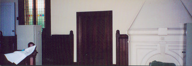
Photograph - Former Kew Court House : Police locker room, 1996
A civic campaign for new public offices developed in Kew in the 1880s. After much deliberation, the location chosen was the junction of Bulleen and Cotham Roads. The buildings were designed by George Watson and John Henry Harvey, architects within the Department of Public Works (Victoria). Building was commenced in 1887, and after one year, the buildings were opened. The Post Office was transferred to the new Commonwealth Government in 1901. The Police Station and Court House, sold by the Victorian Government to the City of Boroondara in 2007, are now a community cultural centre and performing arts venue.The buildings were listed on the Victorian Heritage Register Register (HO885) in 1991. They are historically and architecturally significant to the State of Victoria because Watson and Harvey's designs exhibit diversity in integrating civil offices, they accommodate the apex of road junctions, and they demonstrate a departure from the contemporaneously favoured High Victorian Classical to the Queen Anne style in the design of civic buildings.Interior of the Kew Court House, formerly the courtroom, and later the Police Briefing Room and Locker Roomkew court house, public offices -- kew (vic), kew police station -
 Kew Historical Society Inc
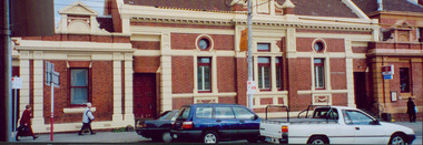
Photograph - Former Kew Court House : High Street elevation, 1996
A civic campaign for new public offices developed in Kew in the 1880s. After much deliberation, the location chosen was the junction of Bulleen and Cotham Roads. The buildings were designed by George Watson and John Henry Harvey, architects within the Department of Public Works (Victoria). Building was commenced in 1887, and after one year, the buildings were opened. The Post Office was transferred to the new Commonwealth Government in 1901. The Police Station and Court House, sold by the Victorian Government to the City of Boroondara in 2007, are now a community cultural centre and performing arts venue.The buildings were listed on the Victorian Heritage Register Register (HO885) in 1991. They are historically and architecturally significant to the State of Victoria because Watson and Harvey's designs exhibit diversity in integrating civil offices, they accommodate the apex of road junctions, and they demonstrate a departure from the contemporaneously favoured High Victorian Classical to the Queen Anne style in the design of civic buildings.Panoramic view print positive photograph of the High Street elevation of the Kew Court House.kew court house, public offices -- kew (vic.) -
Kew Historical Society Inc
Print, Post Office and Police Court Kew, 1907-1915
The Kew Historical Society's postcard collection includes views of Kew, Melbourne and Greater Melbourne as well as those including overseas scenes sent or received from Europe or the Middle East. They date from the 1890s to the 2000s. These postcards may or may not include the name of the publisher or printer. A number of the cards were published as parts of popular series. A way of dating early postcards is to identify whether the reverse was divided by a central line which became the norm after 1902 in the United Kingdom. However, other postcards produced after this date do not always conform to this print layout.An enlargement of an original postcard in the collection, created for the purposes of exhibition, depicting the Kew Post Office and Court House (built 1888) on the corner of High Street and Cotham Road. In front of the Post Office is a large Moreton Bay Fig tree. The later Kew War Memorial (opened 1925) necessitated the removal of the tree and the relaocation of the Queen Victoria Jubilee Fountain. kew court house, kew post office -
 Kew Historical Society Inc
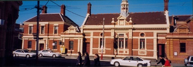
Photograph - Former Kew Court House : High Street elevation, 1996
A civic campaign for new public offices developed in Kew in the 1880s. After much deliberation, the location chosen was the junction of Bulleen and Cotham Roads. The buildings were designed by George Watson and John Henry Harvey, architects within the Department of Public Works (Victoria). Building was commenced in 1887, and after one year, the buildings were opened. The Post Office was transferred to the new Commonwealth Government in 1901. The Police Station and Court House, sold by the Victorian Government to the City of Boroondara in 2007, are now a community cultural centre and performing arts venue.The buildings were listed on the Victorian Heritage Register Register (HO885) in 1991. They are historically and architecturally significant to the State of Victoria because Watson and Harvey's designs exhibit diversity in integrating civil offices, they accommodate the apex of road junctions, and they demonstrate a departure from the contemporaneously favoured High Victorian Classical to the Queen Anne style in the design of civic buildings.Exterior view of the north facing red brick facade of the former Court House and Police Station in High Street, Kew.kew court house, public offices -- kew (vic), kew police station -
 Kew Historical Society Inc
Functional object - Former Kew Police Station : Ceiling light and fitting, 1930-1945
A civic campaign for new public offices developed in Kew in the 1880s. After much deliberation, the location chosen was the junction of Bulleen and Cotham Roads. The buildings were designed by George Watson and John Henry Harvey, architects within the Department of Public Works (Victoria). Building was commenced in 1887, and after one year, the buildings were opened. The Post Office was transferred to the new Commonwealth Government in 1901. The Police Station and Court House, sold by the Victorian Government to the City of Boroondara in 2007, are now a community cultural centre and performing arts venue.The buildings were listed on the Victorian Heritage Register Register (HO885) in 1991. They are historically and architecturally significant to the State of Victoria because Watson and Harvey's designs exhibit diversity in integrating civil offices, they accommodate the apex of road junctions, and they demonstrate a departure from the contemporaneously favoured High Victorian Classical to the Queen Anne style in the design of civic buildings.Ceiling fixture, chain, metal cap and large white glass shade from the former Kew Police Station, removed during renovations in 2007-11, and presented to the Kew Historical Society by the City of Boroondaralight fittings, kew police station -
 Kew Historical Society Inc
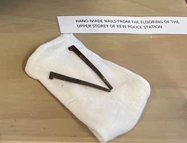
Functional object - Former Kew Police Station : Iron nails, 1888
A civic campaign for new public offices developed in Kew in the 1880s. After much deliberation, the location chosen was the junction of Bulleen and Cotham Roads. The buildings were designed by George Watson and John Henry Harvey, architects within the Department of Public Works (Victoria). Building was commenced in 1887, and after one year, the buildings were opened. The Post Office was transferred to the new Commonwealth Government in 1901. The Police Station and Court House, sold by the Victorian Government to the City of Boroondara in 2007, are now a community cultural centre and performing arts venue.The buildings were listed on the Victorian Heritage Register Register (HO885) in 1991. They are historically and architecturally significant to the State of Victoria because Watson and Harvey's designs exhibit diversity in integrating civil offices, they accommodate the apex of road junctions, and they demonstrate a departure from the contemporaneously favoured High Victorian Classical to the Queen Anne style in the design of civic buildings.Pair of handmade iron nails replaced during the renovations to the Kew Court Housekew police station, nails, building supplies -
 Kew Historical Society Inc
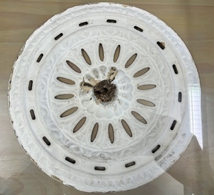
Decorative object - Former Kew Police Station : Ceiling rose, 1888
A civic campaign for new public offices developed in Kew in the 1880s. After much deliberation, the location chosen was the junction of Bulleen and Cotham Roads. The buildings were designed by George Watson and John Henry Harvey, architects within the Department of Public Works (Victoria). Building was commenced in 1887, and after one year, the buildings were opened. The Post Office was transferred to the new Commonwealth Government in 1901. The Police Station and Court House, sold by the Victorian Government to the City of Boroondara in 2007, are now a community cultural centre and performing arts venue.The buildings were listed on the Victorian Heritage Register Register (HO885) in 1991. They are historically and architecturally significant to the State of Victoria because Watson and Harvey's designs exhibit diversity in integrating civil offices, they accommodate the apex of road junctions, and they demonstrate a departure from the contemporaneously favoured High Victorian Classical to the Queen Anne style in the design of civic buildings.Metal ceiling rose from the Kew Police Station, removed during renovations, 2007-11. From original, now concealed ceilings.kew police station, ceiling roses, architectural fittings