Showing 494 items matching " northcote"
-
 Melbourne Tram Museum
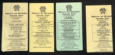
Ephemera - Timetables - MMTB trams - set of 7, Melbourne & Metropolitan Tramways Board (MMTB), 1972
Timetables - provide information on ticketing, fares, timing points, with a description of the route and a map. 1 - West Preston - Northcote - City - routes 9, 10, 11 - Feb. 1972 2 - North Coburg with connecting bus to Fawkner and Gowrie - Upfield on Sundays route 19, 20 and 18 - March 1972 3 - North Balwyn Burwood - City - routes 48, 40, 41, 37, 74, 75, 76, 28 - Feb. 1972 4 - West Coburg - Domain Road and West Coburg City on Sundays - routes 55, 56 and 68 - March 1972 5 - West Maribyrnong - City - (bus routes on Sunday only) - routes 57, 54, 60, 58 and 50 - Feb. 1972 6 - Essendon Aerodrome - City - route 49, 49, 52 and 51 - March 1972 7 - Footscray - Moonee Ponds - bus route on Saturday afternoons and Sundays - route 82 Feb. 1972Yields information about MMTB tram services during 1972Set of seven MMTB tram timetables - multifolded printed on yellow or green paper.timetable, mmtb, route 10, route 9, route 11, route 19, route 18, route 20, route 48, route 40, route 41, route 37, route 74, route 75, route 76, route 28, route 55, route 56, route 68, route 57, route 54, route 60, route 58, route 50, route 59, route 49, route 52, route 51, route 82 -
 Melbourne Tram Museum
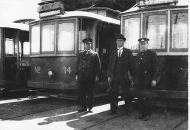
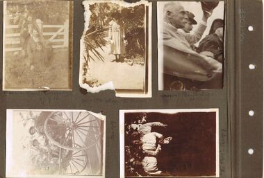
Photograph - Three staff at first Preston Depot, early 1920s
Photograph shows two uniformed men and one in suit and hat standing in front of 3 tramcars protruding from tram shed. The trams would be single truck, possibly R classes. The destination on the closest car appears to read "Depot". One uniform includes cap and tunic with silver or brass buttons up to the neck may indicate an early M&MTB depot starter given the senior age of the man. The other uniform includes cap and double-breasted tunic, possible indicating a line inspector or tramway superintendent. The suited man may also be a senior tramway employee such as the Depot Master. The location is the first Preston Depot opposite the future Preston Workshops. This depot and tramways were built by the Fitzroy, Northcote and Preston Tramways Trust but taken over by the M&MTB in 1920 before operations began. In 1955, the depot was renamed Thornbury Depot when a new Preston Depot was constructed in Plenty Rd. Yields information about staff at the first Preston Depot. Black and white print with no notesfirst preston depot, thornbury depot, plenty road depot, preston workshops, first uniform of m&mtb, silver or brass button, fitzroy northcote and preston tramways trust, depot starter, depot master, line inspector, superintendent -
 Bendigo Historical Society Inc.
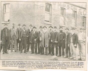
Photograph - CORNISH COLLECTION: VISIT OF BENDIGO MINE MANAGERS TO THOMPSON'S ENGINEERING WORKS, CASTLEMAINE
Photograph. Cornish Collection - visit of Bendigo mine managers to Thompson's Engineering Works, Castlemaine. Article (undated) from Bendigo Advertiser (?) re visit one hundred years ago - with photos of 14 men with part of Thompson & Co brick building in background: : Mr Hicks (Red, White and Blue); Mr Glanville (Hustlers Royal Reserve); Mr Kidd (Shamrock Co.0; Mr Hollow (South Bellevue); Mr Rowe (new Chum Rail); Mr Jas Northcote (Lansell's general manager); Mr Edward (Fortuna-Hustlers); Mr Prior (Garden Gully); Mr J Lonsdale (Shenandoah); Mr Whitford (Lazarus Co,); Mr Harvey (New Chum United); Mr Bradshaw (electrical engineering); Mr Lonsdale (Lazarus Co.); Mr L B McGrath (Thompson's representative).bendigo, gold mining, miners -
 Ballarat Tramway Museum
Magazine, Tramway Museum Society of Victoria (TMSV), "Running Journal Vol. 7 No. 6 December 1970 ", Jan. 1971
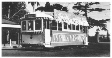
Cover page for the December 1970 issue of the TMSV's "Running Journal" featuring W7 1024 decorated for Christmas on the front cover. (see btm989i3) On page 2 - two photos of horse buses, Northcote and Clifton Hill, and Royal Park and Brunswick, 676 and Y at Footscray (L.Millar Photo). On rear inside cover photos of W7 1010 decorated for Holeproof, W7 1024 decorated for newspaper, Newsday, models of X1 and W5 (A Howlett's) and two photo montages. On rear cover, Ballarat tram 14 decorated for Christmas by Myer's (btm989i1) and Bendigo Birney 28, also decorated for Christmas (btm989i2) for Myers. Then two photos of work at Bylands and one at Bayswater working on Geelong Pengelly No. 22. Printed on glossy white paper. Printed early Jan. 1971 as includes a photo taken on 27/12/1970. See Reg Item 3567 for full copy of this issue of the magazine.trams, tramways, horse buses, decorated trams, myers, christmas -
 Whitehorse Historical Society Inc.
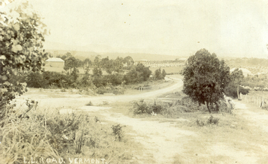
Photograph, L L Road Vermont, late 1800
Dr L L Smith was a pioneer of the Vermont District. He owned 250 acres in the area bounded by Boronia, Canterbury and Heatherdale Roads and the creek. The property was known as L L Vale after which the road was named. Name was changed to Boronia Road in later years. He was a Doctor with rooms in the City, was a member of Parliament.Sepia Postcard of L L Road, Vermont (now Boronia Road) taken in the early 1900s (card is postmarked 27 Aug 1909). Shows the road going down it is presumed to the creek. It is possible that the house is that of Dr.L.L.Smith. See History.|Orchard in background is the Finger orchard. (from Mr. Shambrook - Tim's father)|Information on the back of the Postcard reveal it was sent to Miss Roberts of 61 Hoddle Street Richmond Victoria by Muriel at 37 Victoria Road Northcote and was posted at the Fairfield Post Office Victoria on 27 August 1909. Text is 'Dear Ethel Just a Post Card to let you know I will be out to see you on Monday if convenient. I came down with Mr Hutchinson and he asked me what were we laughing out on the Sunday when he came up. Muriel|See the following references -ND199, 313, 539. 1242, 2013, 3680 & 4295.l l road vermont, boronia road vermont, smith . l l dr -
 Melbourne Tram Museum
Legal record, Melbourne & Metropolitan Board of Works (MMBW), "Melbourne and Metropolitan Board of Works - Agree to construction a sewer to Car Barn Preston", 1990 to 1920
Set of our four legal agreements within a set of three brown manila folders: .1 - "Melbourne and Metropolitan Board of Works - Agree to construction a sewer to Car Barn Preston", dated 26/7/1919 with the Fitzroy, Preston and Northcote Tramways Trust - FNPTT, sealed and signed by the Chair, Member and Secretary of the Trust and same for the MMBW. Single sheet, typed both sides with a location drawing. Folder numbered "23". .2 and .3 - "MMBW Sewer Mains - Prahran and Malvern Tramways Trust" - PMTT containing four separate agreements - 20/8/1912, 15/3/1911, 30/4/1909 and 30/5/1914, all folded, sealed and signed documents bound together. Folder number "291 - 292". .4 - ditto with the Melbourne Brunswick Coburg Tramways Trust, MBCTT, dated 23/4/1915 - has various schedules. Folder number "294".trams, tramways, mbctt, fnptt, pmtt, mmbw, construction, depots -
 Melbourne Tram Museum
Legal record, Melbourne & Metropolitan Tramways Board (MMTB), "Memorandum of Agreement ..... between MMTB and the Australian Tramway Employees Association", Apr. 2020
Set of two agreements dated 23/4/1920 between the MMTB and the Australian Tramway Employees Association .1 - two foolscap pages - pinned in top left hand corner - sets out that the MMTB has taken over from the Tramway Board, annual leave, wages, continuous service, pay rates, car repair sheds, variations, employees and signature block - Alex Cameron, H. Bell and W. O Strangward for the MMTB and John Abfalter and T. Jewell for the ATEA. .2 - three foolscap pages - pinned in top left hand corner - refers to the various Acts that formed the Board and Arbitration Act, the PMTT, Northcote council, MBCTT, carrying past agreements forward, minimum wages for cable trams workers, juniors, cost of living adjustments and application of the agreement. Signature block - Alex Cameron, Ernest Willis, and W. O Strangward for the MMTB and John Abfalter and T. Jewell for the ATEA.trams, tramways, mmtb, unions, agreements, legal agreements, tramway board, workshops, cable trams -
 Melbourne Tram Museum
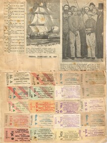
Ephemera - Ticket/s and Newspaper Clipping, John Stanley Caddell, How St Kilda welcomed the King and Queen, c1927
Tickets and newspaper clippings glued to a folded sheet of cardboard comprising: Inside: 20 - MMTB Cable and Electric tram through tickets - transfer and priced, all numbered. Newspaper clipping from Friday Feb 18, 1927 - HMAS Bacchante under sail and Bearded Pioneers at Ballarat. Outside: 4 MMTB ES (Eastern System) tickets - different colours, un-priced, all printed as between Regent St and High St. 1 - Transfer ticket - blue, punched for "to Northcote Town Hall". 1 - MMTB Scholar's concession check - block - printed for Prahran, Malvern and Hawthorn Electric Tramways Newspaper cuttings - How St Kilda welcomed the King and Queen - 6/5/1901 - Duke and Duchess of Cornwall and York. and a cartoon, of an overloaded cable tram trailer with a gentlemen carrying a bag marked CRB and many parcels with the conductor asking "Fares Please!", drawn by Percy Leason.trams, tramways, tickets, cable trams, transfer tickets, cartoons, regent st, crb, royal visit -
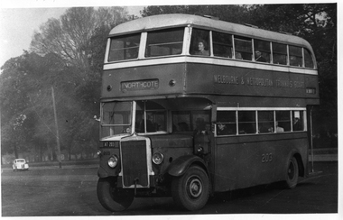 Melbourne Tram Museum
Photograph - Set of 11 Black and White photograph, Ken Flood, 18/04/1974 12:00:00 AM
Set of 11 black and white photographs sent to Keith Kings received from Ken Flood 4/6/1975. .1 - Bus No 203 1940 Leyland TD5c - Turning from Nicholson Street into Gertrude Street. - bound for Northcote. .2 - Bus No 201 1940 Leyland TD5c - In Nicholson Street at Albert Street - Photo. bound for Northcote .3.- Bus No 492 1943 Ford Austerity - at Queens Pde Clifton Hill - Note the Pram and Passenger bus sign by the front doorway. Photo not dated. .4 - Bus No 365 1948 OPS1 - Nicholson Street at Victoria Pde. bound for East Brunswick. Photo not dated. .5 - Bus No 325 1950 OPS4 - Nicholson Street at Victoria Pde. bound for East Brunswick. Photo not dated. Bus did not enter service until 1950. .6 - Bus No 500 1943 Ford Austerity - Marine Pde. Point Ormond. Note the Pram bus sign by the front door. .7 - Bus No 19 1938 Leyland Cub (diesel) with Preston Workshops body. - Lonsdale Street at William Street. W2 No 305 passes behind the bus. Late 1940's photo. .8 - Bus No 143 1940 Leyland TS8c drop enter - in Russell Street at LaTrobe Street bound for North Kew. (Belford Road via Collingwood). Photo not dated. .9 - Bus No 9 1938 Leyland Cub (diesel) with Preston Workshops body. - in Russell Street at LaTrobe Street bound for North Carlton .10 - Bus No 4 1938 Leyland Cub (Diesel) with Preston Workshops body - in Lonsdale Street at William Street. note destination not reset for the return trip. .11 - Bus No 150 1940 Leyland TS11c Drop enter - Nicholson Street at Victoria Pde. Photo not dated. Most of the photos dated 9/6/1949 unless noted otherwise. Notes on photos provided by Rod Atkins - see htd5860doc.pdfOn rear of the photos in ink; .1 - MMTB 203 9/6/49 - K Flood .2 - MMTB 201 - 9/6/49 - K Flood .3 - MMTB Ford #492 - K Flood .4 - MMTB #365 - K Flood .5 - MMTB #325 - K Flood .6 - MMTB #500 Pt Ormond 6/6/49 - K Flood .7 - MMTB #19 9/6/49 - K Flood .8 - MMTB #143 - K Flood .9 - MMTB #4 9/6/49, K Flood .10 - MMTB #4 9/6/49, K Flood .11 - MMTB #150 - K Floodtrams, tramways, buses, double deck buses, prams, mmtb buses, austerity buses, w2 class, tram 305, bus 203, bus 201, bus 492, bus 365, bus 500, bus 19, bus 143, bus 9, bus 4, bus 150, leyland, ford motor company, td5c class, ops1 class, ops4 class, ts8c class, cub class, ts11c class -
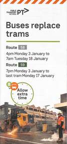 Melbourne Tram Museum
Pamphlet, Yarra Trams, Buses Replace Trams - Routes 58, 59, 86 and 96, 2022
.1 - pamphlet provided at tram stops giving details of the works and bus services for routes 58 and 59 .2 - Project document describing the work and dates - downloaded from the Yarra Trams website after buses were used to replace route 58 from the Royal Children's Hospital rather than from Royal Park Station as originally planned. .3 - as for .1 - for the upgrading of the Merri Creek Bridge - route 86 - see also Reg Item 6066 .4 - as for .1 - for the installation of superstops in Nicholson St between Elgin St and Holden St - route 96Shows the methods that Yarra Trams customers are advised of changes due to track replacement works..1 - Pamphlet - DL, four fold printed on off white paper titled - Buses Replace Trams - Route 58 and Route 59 - Jan 2022 .2 - Project sheet - 3 A4 sheets, titled "Renewal works: Essendon Depot and Mt Alexander Road - 3.1 to 18.1.2022. .3 - Pamphlet - DL 3 fold, Buses Replace Trams, route 86, November 2021 - Merrit Creek Bridge works .4 - Pamphlet - DL - 4 fold, Buses Replace Trams, route 96, January 2020 - Nicholson St works for tram super stops.mt alexander road, tram works, track work, route 58, route 59, yarra trams, ptv, essendon tram depot, route 86, route 96, nicholson st, merri creek, bridges, carlton, super stops, trams, tramways, northcote -
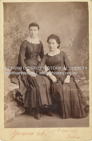 Eltham District Historical Society Inc
Photograph, Possibly Caroline Shillinglaw on left and sister Margaret Shillinglaw, c.1884
Caroline Shillinglaw was born at Plenty, October 6, 1863. She died at the Shillinglaw family cottage 'Wattle Brae' in Eltham April 11, 1947. Caroline never married and was the youngest of Phillip Shillinglaw's siblings. Margaret Shillinglaw was William and Jean Shillinglaw's ninth child. She was born at Northcote March 3, 1856 and died at North Fitzroy September 7, 1933. She never married. Yeoman & Co operated at 47 Chapel St., Prahran from 1883 to 1889. The fashion depicted is typical of mid 1880s. CABINET 1866-1905 The Cabinet photo was introduced in 1866 in answer to a demand for a larger format photograph which could be mounted for a cabinet or on the wall. They were 4.5 inches by 6.5 inches (11.5 x 16.5 cm), more than twice the size of the cdv. They cost about twice as much as a cdv but eventually displaced them. They were not extensively produced until 1880 and had ceased by 1905. Coloured mounts, especially maroon or green, indicate a date between 1880 and 1890. - Frost, Lenore; Dating Family Photos 1850-1920; Valiant Press Pty. Ltd., Berwick, Victoria 1991cabinet photo, marg ball collection, shillinglaw family photo album 3, 1883-1889, 1884, caroline shillinglaw (1863-1947), margaret shillinglaw (1856-1933), unknown, yeoman & co photographer 47 chapel st prahran -
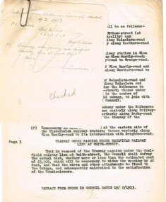 Melbourne Tram Museum
Document - Research Notes, H. S. McComb, "Orders in Council - Relating to Bridges", c1930
Type and hand written notes, on quarto or scrap paper about Orders in councils relating to Melbourne Tramway bridges - 17 sets of notes, each retained by a paper clip. 1 - Caulfield line at Smith St 2 - Church St Bridge Act 3 - Spencer St Bridge Act 4 - Melbourne to Burwood Tramways Act 5 - Footscray Tramway Act 6 - Fitzroy Northcote and Preston Tramways Act 7 - Hawthorn - Under line at Burwood and over line at Burnley 8 - Burke Road Camberwell 9 - St Kilda rail line at Kerford Road 10 - High St Deepdene - Fairfield to Deepdene line. 11 - Glenferrie - Glenferrie Road 12 - Prahran and Malvern Act 13 - Brunswick and Coburg Tramways Act 14 - PMTT - Caulfield and Sandringham rail lines 15 - Glenferrie and Wattletree road and rail lines 16 - Commercial Road and rail crossings 17 - MMTB Act 1928 - various provisionstrams, tramways, bridges, pmtt, mmtb, glenferrie rd, camberwell, htt, mbctt, ftt, fnptt, railways -
 Federation University Historical Collection
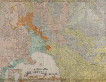
Map, Geological Map of Ascot, 1937, 1937
Coloured plan of Melbourne and suburbs.melbourne, geological, geology, caulfield, brighton, box hill, camberwell, richmond, prahran, st kilda, brunswick, coburg, keilor, braybrook, kew, hawthorn, northcote, williamstown, south melbourne -
 Eltham District Historical Society Inc
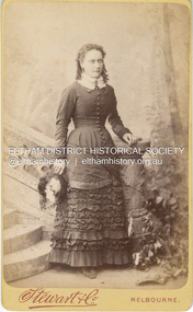
Photograph, Stewart & Co, Possibly Margaret Shillinglaw, c.1882
Margaret Shillinglaw was William and Jean Shillinglaw's ninth child. She was born at Northcote March 3, 1856 and died at North Fitzroy September 7, 1933. She never married. Stewart & Co operated from 217 Bourke St., East from 1871 to 1876 and from 217-219 from 1877 to 1889. Other locations included 42, 284 and 286. Overall, they operated in Melbourne from 1871 through at least 1910 though Carte-de-Visite photos were superseded by 1890. According to Lenore Frost's book, Dating Family Photos 1850-1920, the swathes of contrasting fabric across her abdomen is a peculiarity of 1882. CARTE-DE-VISITE (cdv) 1857-1890 Cartes-de-visite (cdv's) are the most common form of photograph from the nineteenth century, generally measuring two and a half inches by four and an eighth inches (6.3 x 10.5 cm) when mounted, sepia toned, mounted on a card which was generally printed with the photographer's name and address on the back or beneath the portrait. - Frost, Lenore; Dating Family Photos 1850-1920; Valiant Press Pty. Ltd., Berwick, Victoria 1991marg ball collection, shillinglaw family photo album 1, 1871-1890, 1882, margaret shillinglaw (1856-1933), stewart & co photographers melbourne, unknown -
 University of Melbourne, Burnley Campus Archives
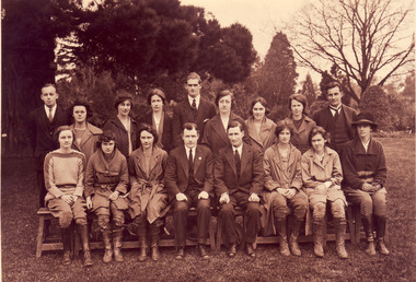
Photograph - Black and white and sepia prints and negatives, C.J. Frazer, Students and Staff. Mr. Rae on the Long Border, 1922-1923
1 copy used in a display in Burnley Library Nov 1995. Note by T.H. Kneen 4 December 1991, "1922 or 3 Back Row (L to R): Fred Sala, Kath Keynes, Miss Pye (Parttime), ?,Fred Gillespie, Clara Broadhurst, Jean Borrett, Kathleen Curry, Alex Jessep. Front Row: Joan Anderson?, Violet Warren?, Miss Northcote, Mr. Rae, ?, Kathie Clark (Tas), Dorothy Allender, Mrs Hedges (Kathleen Curry married Charles Fryer ex-Longerenong student. Together they established Fryer's Nursery in Glenferrie Rd., Hawthorn." (4) 2 copies of photograph, 1 on reverse, "1922 Mr Rae Principal c.1923." Stamp, "Burnley Horticultural College Swan Street, Richmond, Victoria. Photographer was C.J. Frazer, Melbourne (embossed). This photograph appears as an illustration in, "Green Grows Our Garden," A.P. Winzenried, p68. The caption states, "Alex Jessep (sic) admiring an Umbrella Palm from Lord Howe Island near the herbaceous border along the orchard fence." Note by T.H. Kneen 11 December 1991, "Location is the pathway along the Long Border adjoining the Orchard fence. "(1) 2 black and white negatives joined. (2) The 2 negatives developed. (3) 3 copies Group photograph of Students and Staff some seated on a bench and some standing behind.. (4) 2 copies sepia photograph Mr Rae , Principal, on the Long Border (looks like the Orchard Border).On reverse of 1 copy, "1922 Mr Rae Principal, c.1923 Mr. Alex Jessep Lecturer in Botany & Chemistry."Stamp" Burnley Horticultural College Swan Street, Richmond, Victoria."students, staff, mr rae, principal, a.w jessep, lecturer, botany, chemistry, burnley horticultural college, fred sala, kath keynes, miss pye, clara broadhurst, jean borrett, kathleen curry, joan anderson, violet warren, kathie clark, dorothy allender, mrs hedges, charles fryer, fryer's nursery, hawthorn, mr rae principal, c.j. frazer, umbrella palm, lord howe island, herbaceous border, r. fred gillespie, miss northcote, orchard border -
 Melbourne Tram Museum
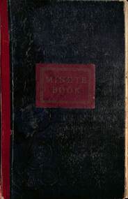
Document - Minute book - Cable tram operational history notes and records, Melbourne & Metropolitan Tramways Board (MMTB), up to 1930
Compiled by an unknown person as a record book of cable tram operational tickets or fare history for each location with general notes and some notes on electric trams. Pages 1 to 23 and pages 123 and 124 - General history of cable and electric trams with notes on tickets, trams, buses, events, and operational management. Compiled through to 26/10/1930, with some loose notes about the final closure of the cable tram system. For each cable tram car house (depot), Power House or Winding house, or route, notes on tickets, dates, rope speed, fares, replacement electric services or buses. Richmond Fitzroy Fitzroy and South Melbourne line Victoria St Clifton Hill Nicholson St Exhibition (route or line) Brunswick Royal Park Carlton Prahran Toorak' Queensberry St North Carlton Esplanade with details on bus services Windsor St Kilda (Brighton Road) North Melbourne West Melbourne' South Melbourne Port Melbourne' Northcote Kew (horse) Elsternwick (electric) At rear of book is four page document that gives information on the electric tram system, routes, cable. fares and first and last services for each line. Mid 1920s as the West Coburg service noted. Yields information Melbourne cable tram fares, ticket issuing and general history of the MMTB.Book - heavy card covers with paper imitation leather finish with red tape on left hand side and labelled "Minute Book", bound with 8 sewn sections, approx 200 foolscap pages, ruled sheets, numbered in pencil from 1 to 124 used to record information in ink.tramways, cable trams, fares, tickets, electric trams, melbourne, mmtb -
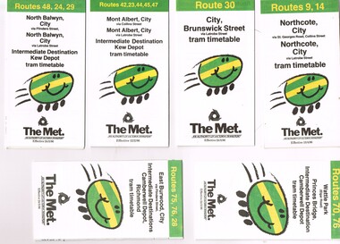 Melbourne Tram Museum
Ephemera - Timetable, The Met, Set of 7 Tram Timetables - The Met, 1986
Set of 7 Tram Timetables, Printed fold out timetable for various tram routes, published by The Met. Provides a map, description of route, time points, timetable, ticketing information (Travel cards and Neighbourhood tickets). .1 - Routes 9 and 14 - Northcote City both via Collins St and Latrobe St. - 13/4/1986 .2 - Route 30 - City - Brunswick St via Latrobe St - 24/3/1986. .3 - Routes 42, 23, 33, 45 and 47 - Mont Albert both via Collins St and Latrobe St. and Kew Depot - 12/2/1986 .4 - Routes 48, 24 and 29 North Balwyn both via Collins St and Latrobe St. and Kew Depot - 24/3/1986 .5 - Routes 70 and 76 - Wattle Park and Camberwell Depot - 24/3/1986. .6 - Route 76, 76 and 28 - East Burwood - City, Camberwell Depot and Richmond - 24/3/1986 .7 - Route 96, 97 and 95 - East Brunswick - 24/3/1986trams, tramways, timetables, tickets, tram services, route 9, route 14, latrobe st, la trobe st, kew depot, route 30, route 42, route 23, route 44, route 45, route 47, route 48, route 24, route 29, route 70, route 76, route 75, route 28, route 96, route 97, route 95, camberwell depot -
 Kew Historical Society Inc
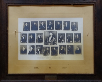
Print, Cr Henry Weedon MLA, & Suburban Mayors, 1907
An article in the Box Hill 'Reporter' (11 October 1907, p.2) refers to the presentation of the artefact to the Kew Town Hall. The report records: 'Presentation to Kew's Ex-Mayor In the mayor's room at Kew on Tuesday evening, Ex-Mayor Cr Wishart was made the recipient of a handsomely-illuminated and exquisitely-framed testimonial as a mark of appreciation by his colleagues of the highly satisfactory manner in which he had discharged the duties appertaining to the mayoral office. .... A framed group of the metropolitan mayors was subsequently presented by Cr Wishart as an addition to the pictures hung in the mayor's room.'The newspaper report in the Box Hill Reporter positively identifies the artefact and how it was placed in the Mayor's Room in the Walpole Street Town Hall. The collage is historically significant as it may include the only photograph of a mayor of a city at this period of time.A large framed photographic collage of Henry Weedon surrounded by the Mayors of Greater Melbourne (holding office for the year 1906-07). The photograph was assembled in recognition of the ‘slight favours to them’ showed by the Lord Mayor. The photograph is dated August 1907. Surrounding the central medallion is, from left to right: Cr. C. C. Mercy (Camberwell), Cr. T. L. Taylor (Northcote), Cr. Thos. Smith (Port Melbourne), Cr. W. Flintoft (Prahran), Cr. W. Collings (Fitzroy), Cr. C. D. Lloyd (Caulfield), Cr. W. Wishart (Kew). Cr. Eli Williams (Coburg), Cr. C. Pattison (Essendon), Cr. A. E. Wells (South Melbourne), Cr. H. B. Gibbs (St Kilda), Cr. J. F. Hamilton (Brighton), Cr. C. Dalley (Hawthorn), Cr. C. L. Davey (?), Cr. J. C. Hill (Heidelberg), Cr. D. Phillips (Brunswick), Cr. M. Alexander (Richmond), Cr. W. Johns (Collingwood), Cr. W. H. Edgar MLC (Malvern), Cr. T. P. Hannah (Williamstown) and Cr. A. A. Harris (Footscray). henry wheedon, c. c. mercy, t. l. taylor (northcote),thomas smith, w. flintoft, w. collings, c. d. lloyd), w. wishart, eli williams, c. pattison, a. e. wells, h. b. gibbs, j. f. hamilton, c. dalley, c. l. davey, j. c. hill, d. phillips, m. alexander, w. johns,w. h. edgar, t. p. hannah, a. a. harris, mayors, kew, henry weedon -
 Melbourne Tram Museum
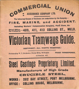
Ephemera, "Victorian Tramways Guide - October 1917", Oct. 1917
Timetable - 36 pages, printed on off-white paper, cover printed on pink paper, centre stapled titled "Victorian Tramways Guide" for October 1917. Details the timetables for the Tramway Board, Northcote Council, PMTT, NMETL, HTT, MBCTT and the VR Brighton line. Gives details of fares, routes, signs, first and last cars. Middle page - has a map and details of a Round trip and shows other lines and change points. Foldout map included on the inside rear cover, showing tramways, railways and rivers. Has many advertisements for the re-election of Sir Frank Madden (he was not re-elected - see http://www.parliament.vic.gov.au/re-member/details/569-madden-frank - accessed 30-12-2016). Polling day 15/11/1917. Has adverts for: Commercial Union Steel Castings Proprietary Limited Myer's Country of Bourke Permanent Building and Investment Society Prohibition - Canada, USA Royal Insurance Company Australian Ladies Commercial College Incley Frederick Collis Tramways Advertising Co. Stott's Business College Chambers and Seymour W. M Richards Huttons Ham Sterling Preparationstrams, tramways, timetables, melbourne, nmetl, vr, cable trams, htt, pmtt, map, advertising -
 Port Melbourne Historical & Preservation Society
Photograph - Port Melbourne Railway United Football Club, Premiers 1925-26, 1926
From William Hegarty's collection, donated by daughter Barbara Hegarty Gardiner. By 1925 Railway United were effectively the PMFC Seconds and were referred to in the media as Port Melbourne Junior Football Club although the Railway United name remained in use locally for many years. The Victorian Junior Football Association (VJFA) had been split into two sections. Section B consisted of teams associated with senior clubs playing in the Victorian Football Association (VFA) with unaligned teams making up Section A. Finals were played between the top teams in each section and then the two winners (premiers) played off in a final match to determine which club won the John Wren Shield as premier of the VJFA. 1925: Port Melbourne 12.11.83 def Williamstown 6.12.48 at Yarraville on 5 Sep 1925 to claim the B Section premiership. In the challenge match for the John Wren Shield played at the Motordrome, 3 Oct 1925, Yarraville 10.15.75 def Port Melbourne 5.10.40. 1926: Port Melbourne 12.11.83 def Northcote 6.12.48 at the Motordrome on 18 Sep 1926 to claim the VJFA VFA Section premiership. Again Port 11.11.77 lost to Yarraville 15.16.106 in the challenge match for the John Wren Shield played at the Motordrome, 2 Oct 1926. Yarraville were then able to claim the John Wren Shield outright and hold it permanently as a result of winning it on three occasions.Photograph of Railway United Football Team Premiers 1925-26sport - australian rules football, jim hall, bill wilson, ern atkinson, george murphy, bert roune (?), mick bragg, alby keogh, william (bill) hegarty, tom davis, bill johnson, archibald (arch) todd, port melbourne railway united football club, port melbourne junior football club, alby mowlam -
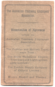
 Ballarat Tramway Museum
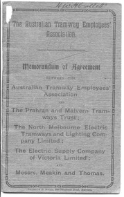
Book, Australian Tramway Employees Association (ATEA), "Memorandum of Agreement - ATEA with PMTT, NMETL, ESCo & Meakin & Thomas", 1913
Four separate agreements, one for each organisation. All details wages and conditions of work and disputes, grievances, and discipline, leave etc. Pages 1 - 10 - agreement with the PMTT - dated 14/1/1913, applied from 1/10/1912 to 1/6/1916. Signed for PMTT by Alex Cameron Chairman; Thomas King Member; and Thomas King Secretary and for Union by Lionel L. Hill President and A. C. Warton General Secretary. Pages 12 - 20 - ditto with NMELTL - dated 14/1/1913, applied from 1/1/1913 to 30/6/1916. Signed for NMETL by L. Voight, A.D. Murdoch and for Union by A. C. Warton General Secretary. Pages 21 - 32 - ditto with ESCo - dated 14/1/1913, applied from 1/12/1912 to 30/6/1916, includes rosters for Ballarat and Bendigo. Signed by William J Home for P. J. Pringle for ESCo and for Union by Lionel L. Hill President and A. C. Warton General Secretary. Pages 33 - 42 - ditto with Messrs Meakin and Thomas, Lessees of the Northcote Cable Tramways. Dated 14/1/1913, applied from 1/12/1912 to 30/6/1916. Signed by F.W. Meakin and Lena Thomas in front of Louis Waxman Solicitor and A. C. Warton, General Secretary. Yields information about the industrial agreements with Tramway operators in Victoria, except for MTOCo.Forty-Four page booklet, off-white paper, saddle-stapled, with additional dark grey colour paper cover titled "The Australian Tramway Employees' Association with the The Prahran & Malvern Tramways Trust / The North Melbourne Electric Tramways and Lighting Company Limited/ The Electric Supply Company of Victoria Limited and Messrs. Meakin and Thomas". Two copies held. "Ballarat Tramway Preservation Society Catalogue No. 213" in ink on top of first page, inside cover on both copies. Copy 1 - has name of "H.W.H.Collett" and "1913" on front cover, and pencil or red pencil notes against various rules in the ESCo section. Copy 2 - some minor pencil marks.trams, tramways, bendigo, ballarat, atea, unions, agreements, esco, nmetl, pmtt, northcote cable trams, meakin & thomas -
 Melbourne Tram Museum
Book, Australian Tramway Employees Association (ATEA), Australian Tramway Employees Association (ATEA), "Memorandum of Agreement - ATEA with PMTT, NMETL, ESCo & Meakin & Thomas", 1913, 1913
Four separate agreements, one for each organisation. All details wages and conditions of work and disputes, grievances, and discipline, leave etc. Pages 1 - 10 - agreement with the PMTT - dated 14/1/1913, applied from 1/10/1912 to 1/6/1916. Signed for PMTT by Alex Cameron Chairman; Thomas King Member; and Thomas King Secretary and for Union by Lionel L. Hill President and A. C. Warton General Secretary. Pages 12 - 20 - ditto with NMELTL - dated 14/1/1913, applied from 1/1/1913 to 30/6/1916. Signed for NMETL by L. Voight, A.D. Murdoch and for Union by A. C. Warton General Secretary. Pages 21 - 32 - ditto with ESCo - dated 14/1/1913, applied from 1/12/1912 to 30/6/1916, includes rosters for Ballarat and Bendigo. Signed by William J Home for P. J. Pringle for ESCo and for Union by Lionel L. Hill President and A. C. Warton General Secretary. Pages 33 - 42 - ditto with Messrs Meakin and Thomas, Lessees of the Northcote Cable Tramways. Dated 14/1/1913, applied from 1/12/1912 to 30/6/1916. Signed by F.W. Meakin and Lena Thomas in front of Louis Waxman Solicitor and A. C. Warton, General Secretary.Yields information about the industrial agreements with Tramway operators in Victoria, except for MTOCo. Forty-Four page booklet, off-white paper, saddle-stapled, with additional dark grey colour paper cover titled "The Australian Tramway Employees' Association with the The Prahran & Malvern Tramways Trust / The North Melbourne Electric Tramways and Lighting Company Limited/ The Electric Supply Company of Victoria Limited and Messrs. Meakin and Thomas".Various doodles on some pages.tramways, ballarat, bendigo, melbourne, atea, unions, agreements, esco, nmetl, pmtt, northcote cable trams, meaking and thomas, rosters -
 Melbourne Tram Museum
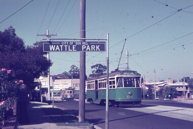
Album - Robert Thomson Slide Collection, AETA Convention 1971
Photo - see pdf file for further information. Number Brief Description RT123 1971 Convention - 9.4.71 - tram 610 - "Special" - Wattle park terminus RT124 Mt Alexander Road - 980 - "Special" RT125 St Kilda Jct - 7.4.71 - "St Kilda Beach" - route 16 RT126 North Balwyn Terminus - 9.4.71 - tram 840 - "Nth Balwyn" route 79 RT127 Preston - tram 980 - "City - Spencer St" - route 9A RT128 St Kilda Jct - "E Brighton Malv Burke Rd" - route 64 RT129 St Kilda Park St Terminus 12.4.71 - tram 394 - "Special" & tram 1017 - "West Preston - Northcote" - route 10 RT130 Carnegie 9.4.71 - tram 106 - "St Kilda Jun" - route 17 RT131 High St - tram 980 - "East Preston" - route 98 RT132 St Kilda Park St Terminus 12.4.71 - tram 894 - "West Preston" - route 10 RT133 St Kilda Park St Terminus 12.4.71 - tram 894 - "West Preston" - route 10 RT134 Wattle Park - 9.4.71 - tram 610 - "City" - route 70 RT135 Wellington Parade - 9.4.71 - tram 840 - "City - Flinders & Spencer St Cnr" - route 23 RT136 Melville Rd West Coburg 12.4.71 - tram 787 - route 55 Demonstrates the work of Robert Thomson in photography, collection and/or production of slidesAssembled album in a black presentation folder of 14 colour slides, collected or produced by Robert Thomson. All photographs have been scanned and placed on the Museum's G drive. A list of all photographs with details has been compiled. melbourne, tramways, trams -
 Melbourne Tram Museum
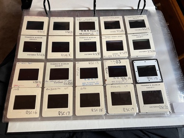
Album - Ron Scholten Slide Collection, Ron Scholten
Photo - see pdf file for further information. Number Brief Description RSC1 PCC 1041 at the gates of Preston Workshops on a test run without it’s trolley retriever RSC2 PCC 1041 in Glenhuntly Road on Route 67 en route to Carnegie crossing the Railway Gates at Glenhuntly Station RSC3 W2 482 stored at Malvern Depot with Olympic Park on the Destination RSC4 Cable Car Set 64 in Swanston St outside Princess Bridge Station in Bound with open top Double Deck Bus, Trak Motors ? Departing from Flinders St Station RSC5 W3 669 in St George Rd at Sumner St en route to Preston Workshops for scrapping RSC6 Cable Car in Lygon St en route to Carlton RSC7 PCC 1041 turning from St Georges Rd into Miller St to enter Preston Workshops RSC8 Flinders St Station with cable cars RSC9 PCC 1041 in strife on it’s maiden day in service. Trams on route 88 delayed in Queens Parade Clifton Hill RSC10 Flinders St at William St with Cable Cars RSC11 L 104 on the fan of the new shed at Malvern Depot on a TMSV tour RSC12 Cable Set 1 after it’s restoration at Preston Workshops on the fan near the front gate RSC13 X1 466 at a suburban terminus of the Footscray System RSC14 X2 680 at Point Ormond Terminus RSC15 An ex Launceston Tram at the outside terminus of the Penny Royal Complex Tramway in Launceston RSC16 Q 148 at Preston Workshops awaiting disposal RSC17 Elizabeth St with Cable Cars RSC18 Elizabeth and Bourke St corner outside the GPO with cable cars RSC19 Collins St with Cable Cars RSC20 A photo taken from the observation deck of the ICI building showing a view of Parliament house with a w class tram in Nicholson St RSC21 Auburn Horse car with a posed photo of all the tramwaymen employed RSC22 Cheltenham Double Deck Horsecar with a full load of passengers RSC23 City of Northcote cable trailer 3 at a terminus RSC24 City of Northcote Cable cars passing in High St Northcote RSC25 St Kilda Rd at Princes Bridge with Cable Cars RSC26 Flinders St with Cable Cars RSC27 Cable Cars RSC28 Bourke St looking towards Elizabeth St from Queen St RSC29 Cable cars in Bourke St at Elizabeth St looking East RSC30 Cable cars in Elizabeth St at the terminus at Flinders St RSC31 Cable cars in Bourke St at Swanston St looking west RSC32 Cable cars in Swanston St at Flinders St looking North RSC33 Cable cars in Collins St near Russell St RSC34 Cable cars in Elizabeth St at Bourke St RSC35 Cable cars in Collins St at Elizabeth St RSC36 Cable Cars in Swanston St at Flinders St RSC37 Cable cars in Collins St RSC38 Cable Cars RSC39 Cable cars in St Kilda Rd near Princes Bridge RSC40 Cable cars in Collins St East of Swanston St RSC41 Cable cars in Spring St outside Parliament house RSC42 K 92 in M&MTB Chocolate and cream livery but with a P&MTT Destination box on Route 14 RSC43 Thornbury depot viewed from Miller St and St Georges rd. Two W2 class cars are laying over between the peaks RSC44 Z3 201 in Met Livery passes D1 3510 in new M Tram livery. A Staff member in uniform stands in the doorway. Dandenong Rd RSC45 D1 3530 advertising Heinekin Super Golf on Route 55 in Royal Park RSC46 D1 3504 in M Tram livery on the reserved track in Matthews Ave near Essendon Airport showing Route 81 Travancore . I suspect it is a private enthusiasts charter due to the Malvern W class run number in the rear windscreen RSC47 D1 3504 on Route 64 in Dandenong Rd in M Tram Livery RSC48 D1 3504 in M Tram Livery at Airport West Terminus RSC49 D1 3504 in M Tram Livery in Union Rd outside the Showgrounds RSC50 D1 3504 at West Maribyrnong Terminus in M Tram Livery RSC51 D1 3503 in M Tram Livery in Malvern Depot RSC52 SW6 960 and VR 53 in Harbour Esplanade for the NMEL&T Co Centenary RSC53 Hawthorn Tramways Trust 32 in Harbour Esplanade for the NMEL&T Co Centenary RSC54 VR 53 & B 2042 in Harbour Esplanade for the NMEL&T Co Centenary RSC55 VR 53 & C 3016 in Harbour Esplanade for the NMEL&T Co Centenary RSC56 NMEL&T Co 13 usually V214 in Harbour Esplanade for the NMEL&T Co Centenary RSC57 NMEL&T Co 13 usually V214 at Preston Workshops for the NMEL&T Co Centenary RSC58 Hawthorn Tramways Trust Lettering on HTT 32 in Harbour Esplanade for the NMEL&T Co Centenary RSC59 Hawthorn Tramways Trust 32 in Harbour Esplanade for the NMEL&T Co Centenary RSC60 Hawthorn Tramways Trust 32in Harbour Esplanade for the NMEL&T Co Centenary RSC61 Hawthorn Tramways Trust 32 in Harbour Esplanade for the NMEL&T Co Centenary RSC62 NMEL&T Co 13 usually V214 at Preston Workshops for the NMEL&T Co Centenary RSC63 W2 516 and another on route 59 wait to shunt at Essendon Airdrome Terminus as W2 571 on route 49 departs. This was the last day of operation. RSC64 Australia’s First Electric Tram at Box Hill with Tramwaymen including H J Hilton who is in the centre RSC65 W2 484 en route to St Kilda Junction and another wait for passengers after a race meeting at Caulfield Racecourse RSC66 X1 463 on the Footscray system en route to Russell St RSC67 Geelong 35 on Chilwell Route, Formerly HTT 13, M&MTB 119, then Bendigo 1 and Ballarat 37 RSC68 P&MTT 4 on Opening Day of the system in Glenferrie Rd RSC69 Bendigo 6 in McCrae St near the Depot end route to North Bendigo RSC70 P&MTT 4 in Glenferrie on opening day of the System RSC71 Scrubber 3 stripped and awaiting scrapping at Preston Workshops RSC72 Scrubber 4 at South Melbourne Depot RSC73 Q 191 & 139 at Preston Workshops awaiting scrapping RSC74 Rail Grinder 3 at Preston Workshops as purchased from Sydney RSC75 Y 469 waits to shunt at Wattle Park Terminus as Y1 613 departs on driver training duties RSC76 VR 53 on the outside roads at Essendon Depot RSC77 W5 796 with three doors and square windows running out of Brunswick Depot in Cameron St, with a supplementary destination board showing “City via Swanston St” RSC78 W2 258 on the wheel grinder road at Brunswick depot RSC79 X2 676 on a TMSV tour, W5 817 & 836 & VR 53 on the open roads at Essendon Depot RSC80 PCC 1041 on test, passes W71035 in High St Preston RSC81 D1 class production number 7 as delivered on test in Matthews Ave RSC82 W2 383 on route 5 turning from the reserved track in Dandenong Rd into St Kilda Rd at St Kilda Junction RSC83 Z3 204 as advertising tram for Vodaphone Grand Prix running into Malvern Depot new shed RSC84 Z1 4 on test in St Georges Rd RSC85 PCC 1041 on Route 96 in Burke St near Exhibition St RSC86 Z1 3 without numbers on test turning from Miller St in St Georges Rd RSC87 Track components stored in Coldblo Rd at Malvern Depot with Z class cars adjacent RSC88 D1 3501 in M Tram Livery on Route 55 in Peel St at Franklin St RSC89 C 3001 in Yarra Trams Livery Porto 018 & D13502 in M Tram Livery on Display in Harbourside Esplanade RSC90 D1 class tram production number 7, in as delivered condition on test in Matthews Ave RSC91 D1 3503 inside Malvern Depot RSC92 SW6 955 and W6 974 in St Kilda at City Rd at Dusk RSC93 Freight Car 19 at Preston Workshops in green Livery RSC94 Rail Grinder 3 in green Livery at South Melb Per Way Yard RSC95 A SW6 class car on route 50 shunting at Elizabeth St Terminus at night, taken from Flinders St Station RSC96 W2 588 & 435 in St Kilda Rd at Batman Ave RSC97 Y1 613 in service at Wattle Park Terminus RSC98 W2 588 in Wellington Parade en-route to the City with a Grand Final Load of passengers followed closely by 384 RSC99 W2 558 on a MCG Footy Special entering the Simpson St sidings RSC100 W3 657 & an L Class in the new shed at Malvern Depot RSC101 Y1 613 in St Kilda Rd on an enthusiasts tour in St Kilda Rd south of St Kilda jun RSC102 Y1 613 on an enthusiasts tour in Clarendon St with the two extra tracks on the Viaduct under construction RSC103 W6 976 on the fan of the new shed at Malvern Depot RSC104 W7 1024 as an advertising car for Bank of NSW at the route 1 terminus at South Melb Beach RSC105 PCC 980 on route 96 in Nicholson St near North Fitzroy Depot RSC106 SW6 890 with dash canopy lighting in Market St on the opening day of William St Services RSC107 W2 444 with big numbers heads a line of footy specials in Simpson St Sidings RSC108 Cable Cars in Elizabeth St RSC109 NMEL&T co 2 with a trailer outside the power station in Mount Alexander Rd RSC110 Alf Twentyman’s cable car set in his Northcote backyard RSC111 Cable Cars in Queens Parade Clifton Hill RSC112 Cable cars in Collins St outside the Townhall RSC113 PCC 1041 at Carnegie terminus RSC114 Cable cars in Elizabeth St RSC115 Cable cars in Collins St near Swanston St RSC116 HTT 19 turns from Riversdale Rd into Camberwell Rd at Camberwell Junction RSC117 W1 419 official builders photo of first car of the class RSC118 Cable car with a full load of passengers RSC119 W1 422 illuminated for the visit of T.R.H. The Duke and Duchess of York RSC120 PCC 1041 in strife on it’s maiden day in service. Trams on route 88 delayed in Queens Parade Clifton Hill RSC121 Bendigo birney in Finn St near North Bendigo terminus RSC122 SW6 in St Kilda Rd at Domain Rd at night RSC123 All 3 of Alf Twentyman’s cable cars in his Northcote backyard RSC124 Cable trailer 256 being unloaded into the shed at Bylands RSC125 Cable grip car 1 being removed from the Melbourne Museum RSC126 Alf Twentyman's cable cars in his Northcote Backyard RSC127 Alf Twentyman's cable cars in his Northcote Backyard RSC128 Alf Twentyman's cable cars in his Northcote Backyard RSC129 Alf Twentyman's cable cars in his Northcote Backyard RSC130 W class car in Swanston St at Collins St RSC131 Y1 469, L & W3 on the run out of Glenhuntly Depot on a tour RSC132 W7 1024 as an advertising tram for Bank of NSW at Clifton Hill RSC133 W2 496 on a footy special in Simpson St Sidings RSC134 W2 as originally converted to a test car at Preston Workshops RSC135 W3 667 in Brunswick Depot with Ellen Butland at the controls RSC136 W3 669 on it’s final run at Victoria Prd & Brunswick St RSC137 W2 571 in Wellington Prd at Clarendon St with a Footy Final load of Passengers RSC138 Y1 613 shunts at Spencer St Terminus as X217 waits on Australia Day Pageant RSC139 PCC 1041 on Rt 96 in Burke St outside the Southern Cross Hotel RSC140 890 with accident damage on the outside roads at Preston Workshops c1978 RSC141 535 on Rt 4 at the old St Kilda Jun c1967 RSC142 1041 on Rt 88 turns from Bourke St into Spring St 1973 RSC143 102 on a tour at Albert Park Beach Terminus Feb 1972 RSC144 833, 835 & 834 in the shed at Malvern Depot c1976 RSC145 281 in Wellington Parade on a football very crowded special c1974 RSC146 464 Ballarat Rd 1960 RSC147 181 Explosives Fty - at Footscray Station - July 1960 RSC148 181 Williamstown Road 1960 RSC149 Cable car set at Alf Twentyman’s c1970 RSC150 X 217 at Malvern Depot c1970 RSC151 X1 465 and T181 Footscray Football ground in Barkly St. c1960 RSC152 Scrubber 5 at South Melbourne depot c1960 RSC153 X1 465 Footscray to Russell St, c1960 RSC154 X1 467 Leeds St Footscray 1960 RSC155 PMTT 4 Glenferrie Road, 1910 RSC156 S 164 at Malvern Depot c1970 RSC157 T178 Footscray c1960 RSC158 Cleaner No. 7 at South Melbourne depot c1960 RSC159 Two Y classes at Princes Bridge / Batman Ave mid 1950s RSC160 Swanston St – Nu color vue slide – M142 Demonstrates the work of Ron Scholten in photography, collection and/or production of duplicate slidesAssembled album in a black presentation folder of 160 colour slides, 8 slide sleeves, collected or produced by Ron Scholten. Many are TMSV or Windsor Publications slides. All photographs have been scanned and placed on the Museum's G drive. A list of all photographs with details has been compiled. melbourne, tramways, trams, cable trams -
 Ballarat Tramway Museum
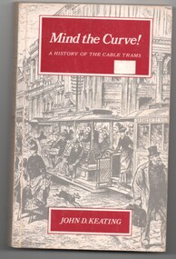
Book, John D Keating, "Mind the Curve", "Hold tight for the Curves", 1970
.1 - Hard bound book, 172 pages, including end covers, 10 sections, title "Mind the Curve", with subtitle "A history of the Cable Trams", stitch bound to hard red Rexene covers with gold block title on the spine only. Dust cover has the title, author, drawing of Bourke St and details of the book and author on the returns. Written by John D Keating, published by the Melbourne University Press in 1970. Has index, acknowledgements, table of contents, list of illustrations and references Looks at the establishment, construction, operation and demise of the cable tram system in Melbourne. Provides location details of the engines houses, tramcars, ticketing, management, politics, the Northcote line and the workers. Has a hand written note written by the daughter of John Caddell, a cable Tammie. On the page opposite the Acknowledgements is a typed note regarding visiting Mr Twentymen's house. .2 on the inside of the rear cover is a photograph and note regarding John Caddell and information about John's retirement from Preston Depot. .3 - Newspaper cutting, "Hold tight for the curves" - The Herald, 15/10/1970 - written by Laurie Power. reviewing the book. Has been adhered to a sheet of A4 white paper.trams, tramways, melbourne, mmtb, cable trams, mto co, horse trams, preston depot -
 Bendigo Historical Society Inc.
Photograph - HILDA HILL COLLECTION: BLACK AND WHITE PHOTOS, 1918-1919
Hilda Hill Collection. Black & White Photograph Collection Double Sided Card 10 Individual Photographs, Family Life During World War 1. Five Children enjoying day out at Pyramid Mineral Springs in Kyneton 27/09/1918 white gate in background. Female in white coat standing in a garden, Dec 30th 1918 The Ranch. General Pau Bendigo 21/10/1918. Two Gentlemen in a gig at Bendigo's Botanical Gardens Jan 1919. Three ladies in white blouses and black dresses 'The Pines' Jan 1919. Mistress Alma Northcote 1918. Easter Monday 1918 Lieutenant King in uniform at the 'The Ranch'. Small dog standing on white chair in front of a fern. Two men sitting on ground with football goal post in background, one dressed in white clothing with tennis racket at his side and the other man in slightly darker clothing with a hat at his feet. Victorian home, verandah with lacework named the Ranch. The house has lacework below the gutter of the front . Medium light coloured picket fence. Paved footpath with narrow nature strip. Tree on nature strip enclosed by a medium height picket fence.history, australian, world war 1 family life, https://en.wikipedia.org/wiki/paul_pau -
Surrey Hills Historical Society Collection
Programme - Ephemera, Chatham Primary School Fathers' Club 'Trial by Jury' programme, 16/11/1929
The program describes the performance as 'original burlesque' and was written, composed and produced by A E Woffinden and A W Sutton, members of the Chatham Fathers' Club, to raise money for the school. There were 250 programs printed at a cost of one pound fifteen shillings. This performance starred 21 of the fathers with Mr W Crellin as the only female character, Miss Eileen Flapper. The Chatham Fathers' Club became renowned locally for the quality of its performances, repeats being given to other community organisations. In the publication 'Chatham Past & Present: A Patchwork of People' there is also a photo of the cast taken in the quadrangle of the school. The original program and photo were lent to the school at the time of the 70 year reunion in 1997 by Mrs Jean Lacy (nee Walker), whose father took part as a member of the jury. Many of the performers were also in the formal photo of the Father's Club, taken in February 1928 on the front steps of the school. The original hangs in the school entry foyer and is reproduced in 'A Patchwork of People: Chatham Past and Present'. In relation to names, these are better identified and the following identifications have been reached by referencing this and the 1931 electoral roll. The geographic spread of addresses reflects that when Chatham opened in August 1927, surrounding schools were overcrowded and some families chose to relocate their children. Albert Ernest Woffinden (manufacturer) lived at 14 Banool Road, Surrey Hills. Alfred William Sutton (clerk) lived at 528 Whitehorse Road, Surrey Hills. Mr A Davidson - not found in electoral roll. Walter Dallas Kinross (mechanic) lived at 72 Empress Road, Surrey Hills. Gilbert Leslie (Bert) Rae (sales) lived at 63 Empress Road, Surrey Hills. Mr Joseph P Braddick (mechanic) lived at 1 Northcote Avenue, Canterbury; now Balwyn (NB/ Name is miss-spelt Braddock in the program). Norman Patrick Smart (bt opr) lived at 61 Sir Garnet Road, Surrey Hills. Henry Albert Wysham (show card writer) lived at 9 Northcote Avenue, Canterbury. Mr Sidney Bessant (labourer) lived at 191 Mont Albert Road, Canterbury. William Morrison (teacher) lived at 37 Chatham Road, Canterbury. William Charles Crellin (breadcarter) lived at 59 Empress Road, Surrey Hills. Mr F Parsons - taken as Fred Parsons (bricklayer) lived at 2 Kaarumba Grove, Balwyn. Mr MacDougal (incorrectly spelt in program) is Dougall MacDougall (gas collector) lived at 5 Wells Street, Surrey Hills. Mr A V Webb - not found. Mr McKie - not found. Victor Harold Theodore Clow (civil servant) lived at 4 Talbot Avenue, Balwyn; listed as T. Clow. Mr M Walker (donor's father) not found in electoral roll for 1931; thought to have lived in Sir Garnet Road. Mr McLeod - a number listed in the 1931 electoral roll. Richard Frost (carriage builder) lived at 341 Mont Albert Road, Surrey Hills. Mr Allen - a number listed in the 1931 electoral roll. Mr J Tulloch - not found in the 1931 electoral roll. This is an example of 'home-spun' entertainment and creativity of the era when the sense of community was very real. It is an example of the fundraising efforts undertaken by school communities to provide 'extras' that would later be regarded as 'basics'. For many years the sense of community in this part of Surrey Hills revolved around Chatham school, the Benson Street Methodist Church and the football club, located at the Canterbury Recreation Ground.A photocopy of the programme for the Chatham Primary School Fathers' Club "Trial by Jury" performance on 16 November 1929. It includes the words of the song 'Carry me back to dear old Chatham'. It lists the performers by character and some details regarding the Chatham Primary School Fathers' Club.chatham primary school, chatham primary school fathers' club, theatrical productions, entertainment, albert ernest woffinden, fundraising, alfred william sutton, walter dallas kinross, gilbert leslie (bert) rae, joseph p braddick, norman patrick smart, henry albert wysham, sidney bessant, william morrison, william charles crellin, fred parsons, dougall macdougall, mr a v webb, mr mckie, victor harold theodore clow, mr m walker, mr mcleod, richard frost, mr allen, mr j tulloch -
 City of Moorabbin Historical Society (Operating the Box Cottage Museum)
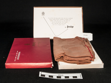
Clothing - Clothing, lady's nylon stockings 'Prestige Wonderfoot'', mid 20thC
Prestige Limited was formed in 1922 by George Foletta to manufacture fine silken hosiery. The company had acquired the Atlas Knitting and Spinning Mills Pty Ltd which had been established in 1920 and produced "Prestige hosiery" from 1921. Prestige Limited merged with Holeproof Hosiery Company (Australia) Pty Ltd in 1964. Both were taken over by Pacific Dunlop in 1968. The Prestige name was dropped in 1978/79. George Gotardo Foletta (1892-1973), hosiery and knitwear manufacturer, was born on 30 January 1892 at Northcote, Melbourne, eldest son of Victorian-born parents Henry Gotardo Foletta, a stonemason of Swiss extraction, and his wife Gertrude, née Bright. Henry repaired the depression-ravaged fortunes of his family by starting a successful fancy goods commission-agency.....George persuaded the demoralized board to restructure around a quality-first marketing policy. By 1924, when George A. Bond & Co. Ltd ( Sydney) was liquidated, Prestige was back in the black. About this time the company became the first Australian knitter to make fully-fashioned silk stockings, outselling the best imported brands and giving Prestige dominance of the local hosiery market. With the arrival of British-trained Leslie Gough in 1926, Prestige entered its period of greatest expansion. By 1933 it was spinning its own silk yarn, had diversified into lingerie and commenced business in New Zealand; three years later it was spinning imported rayon filament into hosiery yarn.A pair of unworn lady's brown nylon 'service weight' stockings made by 'Prestige' Pty Ltd. in the original boxBox Lid: House of / Prestige / ‘monogram’ / WONDERSOFT / SERVICE WEIGHT “FOOT COMFORT’ NYLONS. Box inside lid : ‘monogram’ / You will have day long comfort when your feet are cushioned / with the softness and the smoothness of ‘Prestige “Foot Comfort” nylons. The secret is in the Nylon soles / …and you will find these “ Foot Comfort” / soles in ultra sheer, sheer, service sheer / and service weight nylons. / by Prestigeclothing, stockings, nylons, prestige hosiery pty ltd, melbourne, bentleigh, cheltenham moorabbin -
 Kew Historical Society Inc
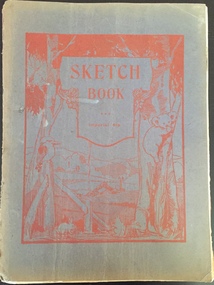
Album, Kenneth Bailey, Art Therapy Sketchbook : Kew Mental Hospital, 1952-1969
Herbert Joseph Chambers was born in 1912 in Clifton Hill, Victoria. Later he was to live in Clark and Charles Streets in Northcote, in South Caulfield, and finally in Mentone. While he may have worked at the Kew Asylum before 1945, that year was when he was presented with a Certificate issued by the Department of Mental Hygiene (Victoria) declaring that he had completed training and passed the examinations required to work as a 'Mental Attendant’. The document is dated 19th December 1945 and signed by the Director of the Department and by the Co-Examiners. From at least 1945, he was to work as a member of the male staff of the Asylum, mainly in the Refractory Ward. A donor gifted to the Kew Historical Society in February 2019 a number of items collected by Herbert Chambers in his work at the Asylum. These include his Certificate of Registration, a photograph taken of him with two colleagues at Circular Quay in Sydney, a notebook containing ‘SP’ betting records of male asylum staff, and five sketchbooks with artwork created by Kenneth Bailey, a patient of the Asylum. Herbert Chambers’ period of employment at the Kew Asylum coincided with the employment of the English psychiatrist Dr Eric Cunningham Dax (1908-2008) as Chairman of the Mental Hygiene Authority in 1952. Dr Dax introduced an art therapy program into Victorian psychiatric hospitals, including Kew, where it is likely that the five sketchbooks were created. The sketchbooks are believed to have been presented to Chambers by ***** as a “gift for looking after him”. Herbert Chambers retired from the Kew Asylum in c.1970 after working there for almost thirty years.The Kew Historical Society has been the recipient of a number of important collections relating to the Kew Mental Hospital and the Children's Cottages, Kew, including their former incarnations. This is an important donation in this context as it includes five sketchbooks by a patient in an art therapy program at the Hospital. Art therapy programs were introduced by Dr Eric Cunningham Dax to Victorian asylums in the 1950s. The sketchbooks contain incomplete drawings and finished artworks. The donor believes that the patient who created the sketchbooks suffered from Schizophrenia. The sketchbooks are historically significant as representative examples of works created by patients in the program and for what they reveal about how mental illness may be manifested in a patient's artworks. The most significant repository of comparable works is held by the Dax Centre at Melbourne University.One of five sketchbooks with illustrations by Kenneth Bailey, a patient of the Kew Mental Hospital in an art therapy program, during the 1950s or 1960s. No work is dated although a number of the drawings/paintings are signed with the artist's name. art therapy, kew mental hospital, herbert joseph chambers, dr eric cunningham dax -
 Kew Historical Society Inc
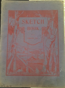
Album - Art therapy sketchbook, Kenneth Bailey, Imperial 4to Sketchbook, Kew Mental Hospital, 1952-1969
Herbert Joseph Chambers was born in 1912 in Clifton Hill, Victoria. Later he was to live in Clark and Charles Streets in Northcote, in South Caulfield, and finally in Mentone. While he may have worked at the Kew Asylum before 1945, that year was when he was presented with a Certificate issued by the Department of Mental Hygiene (Victoria) declaring that he had completed training and passed the examinations required to work as a 'Mental Attendant’. The document is dated 19th December 1945 and signed by the Director of the Department and by the Co-Examiners. From at least 1945, he was to work as a member of the male staff of the Asylum, mainly in the Refractory Ward. A donor gifted to the Kew Historical Society in February 2019 a number of items collected by Herbert Chambers in his work at the Asylum. These include his Certificate of Registration, a photograph taken of him with two colleagues at Circular Quay in Sydney, a notebook containing ‘SP’ betting records of male asylum staff, and five sketchbooks with artwork created by Kenneth Bailey, a patient of the Asylum. Herbert Chambers’ period of employment at the Kew Asylum coincided with the employment of the English psychiatrist Dr Eric Cunningham Dax (1908-2008) as Chairman of the Mental Hygiene Authority in 1952. Dr Dax introduced an art therapy program into Victorian psychiatric hospitals, including Kew, where it is likely that the five sketchbooks were created. The sketchbooks are believed to have been presented to Chambers by **** as a “gift for looking after him”. Herbert Chambers retired from the Kew Asylum in c.1970 after working there for almost thirty years.The Kew Historical Society has been the recipient of a number of important collections relating to the Kew Mental Hospital and the Children's Cottages, Kew, including their former incarnations. This is an important donation in this context as it includes five sketchbooks by a patient in an art therapy program at the Hospital. Art therapy programs were introduced by Dr Eric Cunningham Dax to Victorian asylums in the 1950s. The sketchbooks contain incomplete drawings and finished artworks. The donor believes that the patient who created the sketchbooks suffered from Schizophrenia. The sketchbooks are historically significant as representative examples of works created by patients in the program and for what they reveal about how mental illness may be manifested in a patient's artworks. The most significant repository of comparable works is held by the Dax Centre at Melbourne University.One of five sketchbooks with illustrations by Kenneth Bailey, a patient of the Kew Mental Hospital in an art therapy program, during the 1950s or 1960s. No work is dated although a number of the drawings/paintings are signed with the artist's name. art therapy, kew mental hospital, herbert joseph chambers, dr eric cunningham dax