Showing 9545 items matching " street names"
-
 Bacchus Marsh & District Historical Society
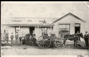
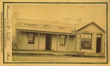
Photograph, Harvest Home Hotel Main Street Bacchus Marsh c.1880s-1890s
... the Harvest Home Hotel situated in Main Street Bacchus Marsh. The name... situated in Main Street Bacchus Marsh. The name of the hotel can ...The Harvest Home Hotel was licensed as a beer shop in 1866. Patrick Vallence was the licensee. On his death in 1874 his widow Mrs M. A. Vallence obtained the license. The date that this image was created has not been identified. Around 1883 George Marshall was leasing the hotel. The people in this image are could be members of the Marshall family and some of the staff who worked in the hotel at this time. Following a decrease in the population of Bacchus Marsh by 1911 the hotel had lost its licence. The Vallence family still owned the building after the loss of the hotel license in 1911and it was used for some years after this as a private residence by some members of the Vallence family. Small black and white photograph. The image depicts the Harvest Home Hotel situated in Main Street Bacchus Marsh. The name of the hotel can be seen above the verandah roof. The building appears to be of stone with decorative stonework corners. A verandah is inset to the left of a gabled front section which has its own door and window. A deep gutter runs along the front of the hotel, with a slab acting as a bridge to the road. Standing in front of the building facing the camera is a group of adults and children, men and women and boys and girls. A four seated buggy drawn by a single horse is also present in the image. The lantern erected above the horse trough can be seen.hotels bacchus marsh, vallence family bacchus marsh, marshall family bacchus marsh, harvest home hotel bacchus marsh -
 Kew Historical Society Inc
Plan - Subdivision Plan, J R Mathers & McMillan, Plan of Subdivision of Part of Crown Portion 83 at Kew : LP6669, 1923-1939
... starting point for the surveyors, but the Road named ‘Street Street... for the surveyors, but the Road named ‘Street Street’ indicates the role ...In 1888, in the section of Park Hill Road between Belmont Avenue and Normanby Road there was only one street running between Park Hill Road and Cotham Road. This was Park Road, later to be named Adeney Avenue. Subsequent 20th century subdivisions created the ‘through roads’ of Cecil Street, Wimba Avenue, Florence Avenue, Marshall Avenue, Uvadale Road, and Barrington Avenue. This subdivision represents an attempt by auctioneers, rather than town planners to create an urban environment from larger residential allotments or in many cases farmland. Existing streets such as Parkhill and Normanby Roads provided a convenient starting point for the surveyors, but the Road named ‘Street Street’ indicates the role of the private surveyor in creating streets. Given that a number of allotments are listed as sold on the plan, the street is presumably Cecil Street. Even those lots that had been sold do not quite match the dimensions of the blocks in this parcel of land today, indicating that either further subdivisions or boundary alterations occurred.Subdivision plans are historically important documents used as evidence for the growth of suburbs in Australia. They frequently provide information about when the land was sold as well as evidence relating to surveyors and real estate and financial agents. The numerous subdivision plans in the Kew Historical Society's collection represent working documents, ranging from the initial sketches made in planning a subdivision to printed plans on which auctioneers or agents listed the prices for which individual lots were sold. In a number of cases, the reverse of a subdivision plan in the collection includes a photograph of a house that was also for sale by the agent. These photographs provide significant heritage information relating house design and decoration, fencing and household gardens.The photograph may also be aesthetically significant depending on the importance of the photographic atelier.Hand-drawn subdivision plan of 19 lots facing Parkhill Road, Normanby Road, and an unnamed street [now Cecil Street] in Kew.Estate Agent notes in ink indicate those lots which had sold.subdivision plans - kew, parkhill road - kew, cecil street - kew, normanby road - kew, cecil street -kew, parkhill road - kew, normanby road - kew, crown portion 83 - kew -
 Bendigo Historical Society Inc.
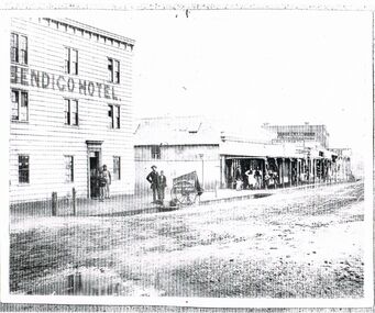
Photograph - BLACK AND WHITE PHOTOGRAPH OF THE BENDIGO HOTEL
... the proceedings in the street. Two shops are name; J. Holdsworth and Glass... watching the proceedings in the street. Two shops are name; J ...Black and white photograph of the Bendigo Hotel located in Bridge street. All nine windows are multi paned. There are two men and a boy standing in the doorway. Opposite the door stand and man and a boy near the cart belonging to Batchelder the Photographer. The man is wearing bowler hat. A corrugated iron fence spans the gap to the next building. The first building in the line is build using corrugated iron for the roof and walls. These retail establishments have a verandah along the footpath. A small group of retail staff are standing around watching the proceedings in the street. Two shops are name; J. Holdsworth and Glass & China warehouse. There may have been recent rain as the roadway appears to be puddled and quite damp.bendigo, history, buildings/streetscapes -
 Brighton Historical Society
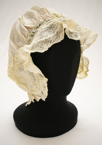
Bonnet, circa 1900s
... as the Hayball Bros. Hayball Court, which runs off New Street, is named..., which runs off New Street, is named after the family. Robert's ...This bonnet is part of a collection of clothing donated to the Brighton Historical Society by Dr William and Helen Wells. It is believed to have belonged to William's grandmother Winifred Marshall (nee Hayball, 1886-1971). William's family has had a long association with Brighton, dating back to the town's earliest days in 1843 when his ancestors Robert and Eliza Hayball, who had emigrated to Melbourne two years prior, established a wattle-and-daub hut in what is now New Street, close to Tovell Street. Robert established a business as a timber merchant on the opposite side of New Street. His sons, Robert, William and Edwin took over the firm following his retirement, trading as the Hayball Bros. Hayball Court, which runs off New Street, is named after the family. Robert's son William (1855-1926) married Jessie Robertson and had four children. Their eldest, Winifred Grace Hayball (1886-1971), married Andrew Hollingsworth Marshall at the Black Street Congregational Church in 1907. They subsequently lived in Hill Street, Hawthorn, before moving into a house designed by Andrew and Winifred's brother Robert at 39 Bay Street, Brighton in 1915. Their daughter, Dorothy Marshall (1910-2000) married Robert George (Argie) Wells in 1937 at Wesley College Chapel. They lived in East Malvern until 1947, when they moved into a newly built home in Hawthorn Road, East Brighton, where they lived for the rest of their lives. Their son, William Wells (b. 1939) married Helen Pickering in 1968 and the couple have lived together in Brighton ever since.Pale pink silk bonnet (sleeping or house cap) with cream lace edging. The bonnet is embellished with oval-shaped embroidered appliqué on either side, featuring floral design in white and pale yellow, blue and green. A cream silk ribbon and a row of pale blue and green rosettes run along the top edge between the two appliquéd segments. A length of elastic is sewn through the bottom edge.wells family, winifred grace hayball, winifred grace marshall, bonnet, 1900s -
 Eltham District Historical Society Inc
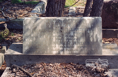
Negative - Photograph, Harry Gilham, Grave of Ellen and Ernest James Andrew, Eltham Cemetery, Victoria, Sep 2009
... and Andrew Oval in Diamond Street are named after him. Ernie died... and Andrew Oval in Diamond Street are named after him. Ernie died ...Ernest James Andrew was the son of William Bravery and Ellen Andrew. The Andrews moved to Eltham in the 1850s and opened a produce store on "Policeman's Hill", at the corner of Maria Street (now Main Road) and Franklin Street. William took a lively interest in the public affairs of the town and district, and with his wife Ellen continued to run the store for some fifty years. He died in 1907 and is buried with his wife in Eltham Cemetery. Ernest took over the business, which became a general store and newsagency. Later, it shifted to the main Eltham shopping centre as a combined newsagency and haberdashery/clothing shop. The original weatherboard building at the corner of Franklin Street was replaced around 1940 by a brick structure, which is now a cafe called Zen Den. Ernie too was married to an Ellen and they lived in Arthur Street at so-called "Cook's Cottage" (due to its resemblance to Captain Cook's Cottage in Fitzroy Gardens). He was an Eltham Shire Councillor between 1920 and 1950 and was Shire President for 1930 and 1947 as well as a Trustee for the Eltham (Public) Hall in Henry Street from the time it was purchased in 1922 until 1940. Andrew House at Eltham High School and Andrew Oval in Diamond Street are named after him. Ernie died in 1950 and is buried with Ellen in Eltham Cemetery. In his Will he made provision to the Eltham War Memorial Trust for funding of the Eltham War Memorial Gates – “These Memorial Gates were donated by the Late Cr. And Mrs E.J. Andrew”. In Memory Of Ellen Beloved Wife of E.J. Andrew Died 13th July 1946 Faithfull Always Also the Above Ernest James Andrew Died 29th March 1950 Councillor Shire of Eltham 30 YearsRoll of 35mm colour negative film, 6 stripsKodak GC 400-9eltham cemetery, gravestones, councillors, ellen andrew, ernest james andrew, shire of eltham -
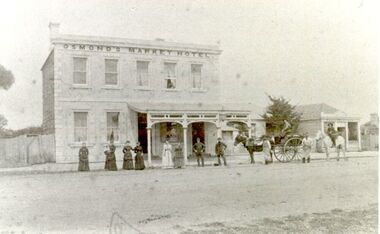
 Port Fairy Historical Society Museum and Archives
Photograph
... street, hence the name Market Inn. William died in 1876 and his... on the opposite side of William street, hence the name Market Inn ...William and Emma Osmond with two small children arrived in Belfast in 1852 as assisted migrants assigned to R. H. Woodward . Two years later William was rated for a two room stone house in William street. By 1868 William Osmond was in business as a Butcher and was the holder of a Beer and Colonial wine license for his home which now numbered eight rooms. The license having been granted he opened the Volunteer Arms there, which he operated for two years whilst he had built, the two storied stone building next door, to take advantage of the fact that a livestock sale yards was operating on the opposite side of William street, hence the name Market Inn. William died in 1876 and his sons continued to run the hotel until 1916, when the building was sold and the license transferred to Harold Revell, a retired farmer. The license was revoked in 1918. and the building became a private dwelling . The building is still standing although the market for which it was named is long gone. It is now a private home and Art Gallery. Image of the building as it presents todayblack and white photograph of Two story bluestone market hotel with rendered front and checkered quoinshotel, building, william street, market, osmond, volunteer arms -
 Port Fairy Historical Society Museum and Archives
Photograph, Market Inn
... street, hence the name Market Inn. William died in 1876 and his... on the opposite side of William street, hence the name Market Inn ...William and Emma Osmond with two small children arrived in Belfast in 1852 as assisted migrants assigned to R. H. Woodward . Two years later William was rated for a two room stone house in William street. By 1868 William Osmond was in business as a Butcher and was the holder of a Beer and Colonial wine license for his home which now numbered eight rooms. The license having been granted he opened the Volunteer Arms there, which he operated for two years whilst he had built, the two storied stone building next door, to take advantage of the fact that a livestock sale yards was operating on the opposite side of William street, hence the name Market Inn. William died in 1876 and his sons continued to run the hotel until 1916, when the building was sold and the license transferred to Harold Revell, a retired farmer. The license was revoked in 1918. and the building became a private dwelling . The building is still standing although the market for which it was named is long gone. It is now a private home and Art Gallery. Image of the hotel with its verandah intact and buildings to the rightBlack and white photographhotel, building, william street, osmond family, market, inn -
 Port Fairy Historical Society Museum and Archives
Photograph
... street, hence the name Market Inn. William died in 1876 and his... on the opposite side of William street, hence the name Market Inn ...William and Emma Osmond with two small children arrived in Belfast in 1852 as assisted migrants assigned to R. H. Woodward . Two years later William was rated for a two room stone house in William street. By 1868 William Osmond was in business as a Butcher and was the holder of a Beer and Colonial wine license for his home which now numbered eight rooms. The license having been granted he opened the Volunteer Arms there, which he operated for two years whilst he had built, the two storied stone building next door, to take advantage of the fact that a livestock sale yards was operating on the opposite side of William street, hence the name Market Inn. William died in 1876 and his sons continued to run the hotel until 1916, when the building was sold and the license transferred to Harold Revell, a retired farmer. The license was revoked in 1918. and the building became a private dwelling . The building is still standing although the market for which it was named is long gone. It is now a private home and Art Gallery. the 4 people in the photograph are probably the Osmond sonsPhotograph of an earlier time when a verandah existed on the front and the butcher shop was attachedBlack and white photograph 2 photos exposed togetherhotel, osmond, william street, market -
 Warrnambool and District Historical Society Inc.
Visiting Cards, 1930s?
... Princess Street and Little Wyton at 3 Nelson Street. Wyton... Princess Street and Little Wyton at 3 Nelson Street. Wyton ...These items came from the estate of the Misses Ardlie, (Dorothy and Agnes). They are visiting cards for their father and themselves. Dorothy Ardlie (1910-1993) and Agnes Ardlie (1915-1993) were the daughters of Arthur and Ethel Ardlie of Warrnambool, the granddaughters of the prominent Warrnambool lawyer, William Ardlie and his wife Mary and the great granddaughters of John and Mary Ardlie, pioneer settlers in Warrnambool. Visiting cards were used for business purposes or when making formal calls to other families. These cards show two residences of Dorothy and Agnes – Aroona, 19 Princess Street and Little Wyton at 3 Nelson Street. Wyton was the name of one of Captain John Ardlie’s ships. The fact that the Misses Ardlie had visiting cards are an indication that they were two of the more affluent and high profile members of Warrnambool society in the 20th century. These cards are of interest, firstly as an example of a visiting card used in the early to mid 20th century and secondly as mementoes of the Ardlie family of Aroona, Warrnambool. .1 These are 9 identical white visiting cards for Agnes Ardlie. The cards are rectangular in shape and have black cursive printing. .2 These are 2 white visiting cards for Miss Ardlie. They are rectangular in shape and have black cursive printing and alterations in blue ink handwriting. .3 These are 5 white visiting cards for Arthur Ardlie. One card is very discoloured. The cards are rectangular in shape and have black cursive printing and alterations in blue ink handwriting on two of them. ardlie family,, warrnambool, warrnambool lawyer, -
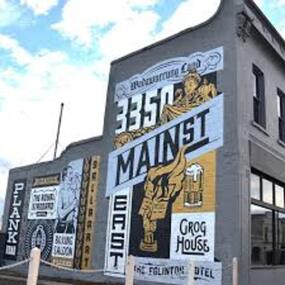 City of Ballarat
Artwork, other - Public Artwork, Travis Price, Main Road Mural by Travis Price, May 2018
... . It had several names: Main Street before 1858, Plank Road between.... It had several names: Main Street before 1858, Plank Road between ...Whilst my main focus for the artwork design was on the Hotels on Main Road, I felt there was an opportunity to tell a broader story of Main Rd and combine/include some interesting pieces of information from many stages of the history of Main Road. Considering that at one point in time there would have been at more than six hotels in this very short section of street….there’s no doubt Main Rd was an epicentre of communication and festivities for the Goldfields of Ballarat. “No matter what luck he had, every miner needed supplies, food and something to entertain him when he was not searching for gold.” Described as being an overcrowded jumble of muddy streets loosely arranged around mining camps...and loud, muddy, colourful and sometimes illicit. I wanted the artwork composition to consist of overlapping images and text to reflect this sense of hustle and bustle. Main Road Mural tells the broader story of the history of Main Road in Ballarat. In 2018, the City of Ballarat commissioned local Ballarat artist Travis Price to create an artwork to align with the Main Road Revitalisation Project and deliver a key component of the storytelling (heritage interpretation) project that spans the length of the shopping precinct. The artwork is featured on a prominent site in the shopping precinct of main road and tells the story of Main Road through depicting key timeline events. Main Road, as its name suggests, was one of the main entries to the mining areas of East Ballarat. It had several names: Main Street before 1858, Plank Road between 1858 and 1868 and Main Road from 1868 onwards. The centre of mining life, it was crowded, prosperous, raucous and dirty. Painted mural on shop wall in Main Road, BallaratBallaarat, Gold Fever, The Royal Standard Hotel, Flood, Boxing Saloon, Plank Road, Kulin Nation, 3350, Election, East, Grog House, The Scandinavian Hotel. Images; Chinese lantern, Pick & Shovel, Miners Licence burning.main road history, ballarat hotels, gold fever, wadawurrung, kulin nation -
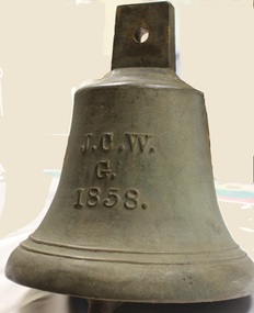 Wodonga & District Historical Society Inc
Functional object - Gordon Family Orchard Bell
... , Charles and Vermont streets in Wodonga are named after the family..., Charles and Vermont streets in Wodonga are named after the family ...The Gordons were architects and were associated with many buildings still standing in Albury and Wodonga, St Patrick's Church and the de Kerilleau Homestead among them. They established Vermont Orchard on 74 acres to the south of the Wodonga settlement. Here they grew fruit and nuts for the domestic and export market. The enterprising family also set about transforming some of the land by clearing it, creating streets and making general improvements. It was the biggest subdivision in Wodonga at the time. The 234 allotments in the Wodonga Estate were put up for sale by auction in May 1890. A total of 200 people were said to have attended. Gordon, William, Charles and Vermont streets in Wodonga are named after the family. This bell was used at the Vermont orchard to signal the beginning and end of the working day, as well as lunch breaks.The Gordon Family orchard bell is made of cast iron. It includes the inscription "J. C. W../G./1858." This is thought to represent the initials of John Gordon and sons Walter Joseph and Charles Goodwin Sylvester Gordon. There is some conjecture about this due to the date "1858". John was born in London, England in 1823 and died in 1880. Walter is generally accepted to have been born in 1857 and died 1903. In one family tree Charles is recorded as being born on 28 January 1858 but his birth was registered in 1860. The mystery of the date is therefore not fully resolved.On one side of the bell "J. C. W../G./1858."gordon family wodonga, gordon and gordon architects, vermont wodonga -
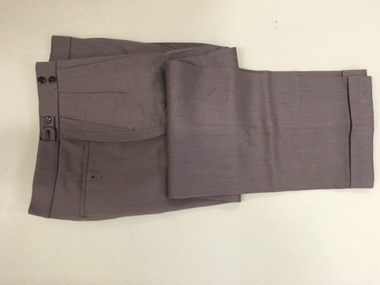 Warrnambool and District Historical Society Inc.
Pants, Fletcher Jones, Mid 20th century
... Street Warrnambool, officially named Pleasant Hill. In 1951... Street Warrnambool, officially named Pleasant Hill. In 1951 ...These trousers have been made by Fletcher Jones and Staff. This business was established by David Fletcher Jones (1895-1977) in 1924 when he leased three shops in Liebig Street, Warrnambool. In 1928 he moved his business to the main retailing area near the Liebig Street/Koroit Street intersection. In 1931 a shop built to Fletcher Jones’ requirements was erected and by 1938 he had a staff of 40. By 1945 FJ trousers were sold in 123 stores in Victoria and in 1948 the Fletcher Jones factory was established in Flaxman Street Warrnambool, officially named Pleasant Hill. In 1951 the company became Fletcher Jones and Staff and by the mid 1970s the staff had 75% ownership. By this time FJ and Staff had become one of the largest clothing manufacturers in Australia with 55 shops and almost 3000 employees. The range of clothing was enlarged to include both men’s and women’s wear. In the 1980s, after the death of Fletcher Jones, the abolition of import tariffs and the availability of cheap imported clothing caused the Fletcher Jones Company to decline and to be sold to a Geelong company. By 2011 all Fletcher Jones shops had closed. These trousers are of great interest as they are a product of a Warrnambool business that was nationally and internationally known in the 20th century for its quality men’s wear, especially the Coverdine brand trousers. The Fletcher Jones business remains one of the most important businesses, (if not the most important), that ever existed in Warrnambool. It employed a great number of local people in the second half of the 20th century, and is remembered with great fondness by many people in the city and surrounds today. The Fletcher Jones Gardens at the Factory site are still maintained today and are a tourist attraction in the city. These are a pair of brown Fletcher Jones trousers made of Coverdine material (87.5% wool with nylon). There is some lining around the waist area and the legs are turned up at the end with some leather binding inside the bottom legs. The waist band is stiffened and is fastened with a metal clip and two buttons. The waist band has two adjustable areas using tabs and two buttons each side. The back pockets also have buttons.fletcher jones and staff, coverdine fletcher jones trousers, history of warrnambool, david fletcher jones -
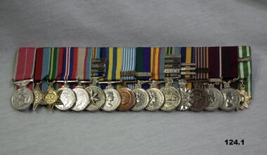 Bendigo Military Museum
Award - MEDAL SET WW2 TO VIETNAM, NAME BADGE, Post 1945
... Lavarack Barracks Townsville, a street was named “Dean drive” after... at the new Coral Lines Lavarack Barracks Townsville, a street ....1) The first medal on the left is the BEM. There are 9 clasps denoting overseas service and 3 clasps denoting Long Service. Francis William (Dinky) Dean enlisted in the 2nd AIF No VX93960 on 16.12.43 age 18 years. He went on to serve with the 2nd/2nd Pioneers in the islands ending up on Morotai at wars end. At the end of 1945 while still overseas 3 new Battalions were formed for service wth BCOF in Japan. They were the 65th, 66th and 67th Bn’s made up from 3 Aust Divisions 6th, 7th and 9th. Frank was one of the first to sign up in the 65th Bn with same Regt No. They moved to Japan in early 1946. While still in Japan in 1947 there was a period called the Interim Army while the 65th, 66th and 67th Bn’s were designated 1st, 2nd and 3rd Bn’s R.A.R, Aust Regular Army. His Regt No changed to 3742 and the 65th became the 1st Batt of the R.A.R. He then served with 1 RAR in Korea 7.4.52 to 28.2.53, 3.3.54 to 24.3.56. Malaya during the Emergency/ Confrontation Oct 1959 to Oct 1961. Vietnam 1.6.65 to 7.6. 66, 18.3.68 to 11.2.69. Malaya 1969-70. Frank was discharged from the Army on 19.12.1975 with the rank of Quarter Master Sergeant with a total of 32 years service. He was the longest serving member of 1 RAR, he had a final posting to RMC prior to discharge. BEM (British Empire Medal) For service in Korea. BCOF (British Commonwealth Occupation Force Japan) RAR ( Royal Australian Regiment) RMC (Royal Military College Duntroon) In 2004 Frank was the guest of honour at the new Coral Lines Lavarack Barracks Townsville, a street was named “Dean drive” after him. Frank passed away on 11.2.2005 age 79 years. .1) Medal set, miniatures, brass plate mounted, set of (16) re F.W Dean BEM. .2) Name badge - battalion badge for unit associations. Black plastic backing with pin, black name on gold background. .2) "Frank Dean 1RAR"numismatics, medals, military, badges, metalcraft -
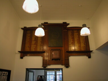 Ballarat Heritage Services
Photograph - Photograph - Colour, Clare Gervasoni, Dana Street Primary School (No. 33) World War One Honour Board, c2010, c2010
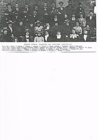
... Timber honour board in the entrance foyer of Dana Street... in the entrance foyer of Dana Street Primary School. names include: L.J ...Dana Street State School was one of the earliest primary schools in Ballarat and was established in 1857.Timber honour board in the entrance foyer of Dana Street Primary School. names include: L.J. Curnow, W. Daly, M. Dixon, S.E.A. Dean, O.T. Dell, R. Eva, F. Eggington, S.P. Eddy, C. Frost, A.W. Fitzgerald, L.G. Fitzgerald, F. Feary, S. Fox, C.H. Falla, C.E. Fa;;a. H.C. Foote, J. Hammond. F.J. Harris. F.E. Hillman, J. Hunter, R.A. Hind, R.V. Horsfall, R.G. Hutson. H. Jones, R. Jamieson, C. Kerr, C.R. Kift, P. Kraiscill, A. Lancaster, C.W. Lee, I.T. Lilburn. R.E.N. Murphy, H. marks, H.H. Martell, P.W.G. Moon. G.P. Merz, A. McGoldrick, W.E. Moon, C.R. Ince, W.J. Peacock, W. Pollard, N. Pinney. C. Pike, J.R. Doney, A.R. Doney, R.E. Rowlands, A.E. Rowlands, L. Rowlands, C. Snell, R. Snell, J. Snell, W. Wilberforce, N.F. Wellington, H. Williams, E. Wallace, S. Wallace, H.S. Yates, A. Yates, T.E. Yates, l.j. curnow, w. daly, m. dixon, s.e.a. dean, o.t. dell, r. eva, f. eggington, s.p. eddy, c. frost, a.w. fitzgerald, l.g. fitzgerald, f. feary, s. fox, c.h. falla, c.e. fa, a. h.c. foote, j. hunter, r.a. hind, r.v. horsfall, r.g. hutson. h. jones, r. jamieson, c. kerr, c.r. kift, p. kraiscill, a. lancaster, c.w. lee, h. marks, h.h. martell, p.w.g. moon. g.p. merz, a. mcgoldrick, w.e. moon, c.r. ince, w.j. peacock, w. pollard, j.r. doney, a.r. doney, r.e. rowlands, a.e. rowlands, l. rowlands, c. snell, r. snell, j. snell, w. wilberforce, n.f. wellington, h. williams, e. wallace, s. wallace, h.s. yates, a. yates, t.e. yates, dana street state school, dana street primary school, j. hammond, f.j. harris, f.e. hillman, i.t. lilburne, r.e.n. murphy, n. pinney, c. pike -
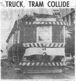 Ballarat Tramway Museum
Newspaper, Herald & Weekly Times Ltd, "Truck, tram collide", "Group charters tram", "Ballarat plans tram museum", 1971
... at the intersection of Princes and Victoria Streets. Gives names... Streets. Gives names of the vehicle drivers and cost of the damage ...Set of three newspaper clippings pasted onto a single sheet of paper with two Punch holes on the left hand side. First clipping from The Courier, Ballarat, 2/4/1971 with photo of tram 28 after is collision the previous day with a semi-trailer at the intersection of Princes and Victoria Streets. Gives names of the vehicle drivers and cost of the damage. Photo is of the tram returning to the depot under its own power. Tram passenger named as Margaret Foley, tram driven by James Mason and the truck driven by Gerald Winter of Gordon. See Reg Item 672.1 for a print of the Courier Photograph. Second is from The Courier, Ballarat, 15/4/1971 of the Brown Hill Progress Association chartering a tram to create interest in the project for the retention of Ballarat's trams. The tram was to leave Drummond and Sturt St. intersection the following Sunday at 1245. Item mentions the election of an interim executive and expression of interest of people outside the city. Third is from The Sun, Melbourne, 31/5/1971 about Ballarat 'tram-lovers' deciding to have a working tramway museum. Quotes Mr. Paul Nicholson, a member of the Ballarat Tramway Preservation Society. Notes that Museum will have eight trams using two miles of existing track around Lake Wendouree. Also notes that the SEC had received 88 applications for the 44 trams in both Ballarat and Bendigo.Image of the 3rd item added 28/3/2011 - see i1 and for the actual cutting i4. Original of newspaper of item 1 - also has items about the future of the railway workshops following a cost review and a story of page 1 of a submission to the Victorian Land Transport enquiry.In red ink on first cutting in top left hand corner "2/4/71" and in blue ink in top right hand corner on second cutting "15/4/71".trams, tramways, accidents, closure, charters, museum establishment -
 City of Greater Bendigo - Civic Collection
Artwork, other - Illuminated Letter of Appreciation, Frederick. de Kock, To the Hon R Clark M.L.A.J.P, 21 September, 1881
... on the corner of Mitchell and King Street, which was later named... on the corner of Mitchell and King Street, which was later named ...Robert Clark was a self educated man who had arrived in Australia with his step father to take up mining in 1854. He worked in several local mines and being familiar with the hardships associated with mining life, helping to establish the eight hour day for miners. Robert married Sarah Jane Kernaghan in 1862 and together they had nine children. Robert Clark was first elected in 1872 and remained a councillor until his death in 1883. He died aged 41 years. This elaborate Letter of Appreciation was hand drawn and painted by artist and photographer Frederick de Kock who was associated with Mr N Caire's photographic Studio, View Place and by 1882 was producing and teaching hand painting on ceramics. In 1883 he advertised as a photographer with his own studio on the corner of Mitchell and King Street, which was later named the Bendigo Portrait Rooms. 180.1 Donated by Jenny Taylor; 180.2 Organisational created. Illuminated Letter of Appreciation in shape of arched window. From Sandhurst Pioneer Co-Operative Co Limited to Robert Clark. Hand drawn and painted on card. Signed by eight directors.mayor city of sandhurst, councillor robert clark, mayor clark, mayor of the city of sandhurst -
 Bacchus Marsh & District Historical Society
Photograph, Harvest Home Hotel Main Street Bacchus Marsh 1883
... situated in Main Street Bacchus Marsh. The name of the hotel can... Home Hotel situated in Main Street Bacchus Marsh. The name ...The Harvest Home Hotel was licensed as a beer shop in 1866. Patrick Vallence was the licensee. On his death in 1874 his widow Mrs M. A. Vallence obtained the license. At the time this image was taken George Marshall was leasing the hotel. Following a decrease in the population of Bacchus Marsh, by 1911 the hotel had lost its licence.The Vallence family still owned the building after the loss of the hotel licence in 1911and it was used for some years after this as a private residence by some members of the Vallence family. Small sepia unframed photograph on card with gold border framing photograph. Housed in the album, 'Photographs of Bacchus Marsh and District in 1883 by Stevenson and McNicoll', the Jeremeas Family Album. The image depicts the Harvest Home Hotel situated in Main Street Bacchus Marsh. The name of the hotel can be seen above the verandah roof. The building appears to be of stone with decorative stonework corners. A verandah is inset to the left of a gabled front section which has its own door and window. On either side of the door beneath the verandah can be seen boot or shoe scrapers. A deep gutter runs along the front of the hotel, with a slab acting as a bridge to the road. Situated in the gutter at the front of the hotel is a water trough which has an arch above it with an ornate lantern, probably to light the front entry and to enable horses to be watered at night. A hitching post is nearby.On the front: Stevenson & McNicoll. Photo. 108 Elizabeth St. Melbourne. COPIES CAN BE OBTAINED AT ANY TIME. On the back: LIGHT & TRUTH inscribed on a banner surmounted by a representation of the rising sun. Copies of this Portrait can be had at any time by sending the Name and Post Office Money Order or Stamps for the amount of order to STEVENSON & McNICOLL LATE BENSON & STEVENSON, Photographers. 108 Elizabeth Street, MELBOURNE. hotels bacchus marsh, stevenson and mcnicoll 1883 photographs of bacchus marsh and district, vallence family bacchus marsh, harvest home hotel bacchus marsh -
 Kew Historical Society Inc
Photograph - 'Mandalay', 3 Molesworth Street (Kew), 1979
... 'Mandalay' at 3 Molesworth Street, Kew was originally named... 'Mandalay' at 3 Molesworth Street, Kew was originally named ...'Mandalay' at 3 Molesworth Street, Kew was originally named 'Kaikoura'. Pru Sanderson's 'Kew Urban Conservation Study' (1988) describes the house as: "The first documentary evidence of this property records that William Dawson was the original owner and occupier of this substantial two-storey mansion, built at the outset of the economic depression of the 1890s. Having an initial N.A.V. of £120 4, the house was occupied by Dawson until at least 1904. This two-storeyed rendered house is Italianate in styling and is dominated by a two-storeyed loggia that spans two facades. At ground floor level it is supported on coupled cast iron colonettes and above has single colonettes that support stilted segmental arches. The house is quite typical of its time, however it bears a strong resemblance to 39 Sackville Street probably by Beswicke and Coote (q.v.), and 'Kawarau'.in Hawthorn, designed by Coote. The similarity of these buildings and the fact that Beswicke and Coote called tenders for a house in Molesworth Street, both suggest that this house was also by that firm.Large original, black and white print positive photograph of 3 Molesworth Street, Kew The two storey Italianate mansion has a double loggia and two bay windows on the side of the property. A car is parked in front.manadaly - molesworth street (kew), historic houses -- kew, italianate architecture -- kew (vic.), kaikoura -- molesworth street -- kew (vic.), beswicke & coote -
 Bendigo Historical Society Inc.
Photograph - CORNISH COLLECTION: PHOTOGRAHS OF BENDIGO HOMES WITH CORNISH CONNECTIONS
... of John Harvey, Golden Square on un-named street corner... Square on un-named street corner (accompanied by copy of head ...Collection of photographs of Bendigo homes with Cornish connections: a. ''Helston'' - home of Richard Jennsion at Long Gully (with separate Obit. Attached - faded (over-exposed?) photo of front/side of house; b. ''Reawla'' - front of wooden house with very prominent palm trees behind picket fence - annotation in writing: '' named after Cornish village (now gone)'' (meaning??); c. front/side photo of ''Fentongrove'' California Gully - former home of Richard Williams - has separate portrait of bearded gent - no name but presumably Richard Williams? D. front/side photo of former home of John Harvey, Golden Square on un-named street corner (accompanied by copy of head & shoulders portrait of Mr John Harvey (poor quality); e. ''Cambourne'', brick home of Ambrose Dunstan, Long Gully with heavily treed garden. Accompanied by a copy of poor quality (newspaper) photo of ''The late Mr A Dunstan (taken when he was Mayor)''; f. front of brick home ''St Leonards'', Don Street, home of Charles Perry; g. copy of photograph of David Lanyon and wife Augusta in front of their miners cottage, Ophir Street. Some printed detail re the couple attached to photo copy.bendigo, history, historical homes -
 Kew Historical Society Inc
Plan, Melbourne & Metropolitan Board of Works : Borough of Kew : Detail Plan No.1572, 1905
... and Fitzwilliam Street. Only two named houses are identified: the quaintly... and Fitzwilliam Street. Only two named houses are identified: the quaintly ...The Melbourne and Metropolitan Board of Works (MMBW) plans were produced from the 1890s to the 1950s. They were crucial to the design and development of Melbourne's sewerage and drainage system. The plans, at a scale of 40 feet to 1 inch (1:480), provide a detailed historical record of Melbourne streetscapes and environmental features. Each plan covers one or two street blocks (roughly six streets), showing details of buildings, including garden layouts and ownership boundaries, and features such as laneways, drains, bridges, parks, municipal boundaries and other prominent landmarks as they existed at the time each plan was produced. (Source: State Library of Victoria)This plan forms part of a large group of MMBW plans and maps that was donated to the Society by the Mr Poulter, City Engineer of the City of Kew in 1989. Within this collection, thirty-five hand-coloured plans, backed with linen, are of statewide significance as they include annotations that provide details of construction materials used in buildings in the first decade of the 20th century as well as additional information about land ownership and usage. The copies in the Public Record Office Victoria and the State Library of Victoria are monochrome versions which do not denote building materials so that the maps in this collection are invaluable and unique tools for researchers and heritage consultants. A number of the plans are not held in the collection of the State Library of Victoria so they have the additional attribute of rarity.Original survey plan, issued by the MMBW to a contractor with responsibility for constructing sewers in the area identified on the plan within the Borough of Kew. The plan was at some stage hand-coloured, possibly by the contractor, but more likely by officers working in the Engineering Department of the Borough and later Town, then City of Kew. The hand-coloured sections of buildings on the plan were used to denote masonry or brick constructions (pink), weatherboard constructions (yellow), and public buildings (grey). Plan No. 1572 represents the built environment bordered by Barkers Road, Wrixon Street, Edgevale Road and Fitzwilliam Street. Other streets identified on the plan include Stansell Street. Plan 1572 shows that by 1903-05, there was only patchy development in this area of Kew, mainly on Edgevale Road and Fitzwilliam Street. Only two named houses are identified: the quaintly named ‘Tweed Cottage’, and ‘Mendip’. The earliest reference to Treed Cottage in Australian newspapers is to the death of Walter Thompson, aged 74 who was a resident there in 1885. His youngest daughter was to die there in 1908. Mendip to the north of Tweed Cottage was owned by Henry Thompson; he was to die in 1901; his wife in 1932. At this period of time, Malin Street and Clivedon Court did not extend to Barkers Road.melbourne and metropolitan board of works, detail plans, mmbw 1572, cartography -
 Kiewa Valley Historical Society
Book - Reference Cricket, The Cricket on the Hearth, circa 1930
... property on the corner of Crisp and Young Streets and was named... of Crisp and Young Streets and was named after her uncle's property ...A text book used by a local Tawonga student in the 1930's. The school she attended was Rosehill Girls School in Albury. This was one of the foundation schools of Scots School, Albury. Rosehill was opened in 1926 by a Miss Lillian Windridge, for both day and boarding students, in a large former residential property on the corner of Crisp and Young Streets and was named after her uncle's property 'Rosehill' near Kyneton in Victoria. It catered from kindergarten to the Leaving Class. The school flourished and extra space was made available at the adjacent 'Springfield' property for more classrooms. In 1934 lack of space forced 'Rosehill' to move to a new location in Kiewa Street. In 1938, Miss Windridge sold the school to Miss Anna Drennan, a well educated Scots woman with a Masters' degree from Edinburgh University. By early 1939 the school was again overcrowded and was moved to the property 'Woodstock' in Schubach Street, East Albury and the name changed to 'Woodstock School for Girls'. In 1972, the Woodstock Presbyterian Girls School and the Albury Grammar School amalgamated to form the Scots School Albury. Wilma's family were one of the early families to settle in the Kiewa Valley and had a property at Tawonga. After her marriage, Wilma moved, with her husband, to Mt. Beauty until 1958 when they moved back to manage the farm and remained there for the rest of her life.It has a social significance as it depicts the standard of literature that was expected to be read and appreciated by students in the 1930's era. As the school was situated in Albury, it meant that the student would have been a boarder as daily transport to and from the Kiewa Valley would have been impossible at that time, unlike the 'School Bus' run that is available today. At this time there was no 'secondary education' available in the valley and education beyond primary school would have been limited to children of families that could afford to send their children to board at privately run schools.Book of literature by Charles Dickens. Has green cover with black lettering and decoration. It seems to be one of a series of books called the 'Highways and Byways of English Literature". On the front cover, at the top, 'Highway and Byways of English Literature'. Centre of page is the title "The Cricket on the Hearth" and the author Dickens. Underneath this is 'Blackies English Texts Edited by W.H.D.Rouse, Litt.D." Across the foot of the page is 'Blackie and Son Limited'. On the first page, hand written in ink is "Wilma Roper, Rosehill G.S.,Albury."secondary education, albury, kiewa valley, tawonga -
 Flagstaff Hill Maritime Museum and Village
Instrument - Clock, c. 1860s
... with now a local street named after him. The Post Office... with now a local street named after him. The Post Office ...The clock was either made or sold by T. Gaunt & Co. of Melbourne, a manufacturer, importer and retailer of a wide variety of goods including jewellery, clocks and watches, navigational and measuring instruments, dinnerware, glassware and ornaments. Thomas Gaunt photograph was included in an album of security identity portraits of members of the Victorian Court, Centennial International Exhibition, Melbourne, 1888. Thomas Gaunt History: Thomas Gaunt established Melbourne's leading watchmaking, optical and jewellery business during the second half of the 19th century. Gaunt arrived in Melbourne in 1852, and by 1858 had established his own business at 14 Little Bourke Street. Around 1869 he moved to new premises in Bourke Street on the corner of Royal Arcade, Gaunt's shop quickly became a Melbourne institution. Gaunt proudly advertised that he was 'The only watch manufacturer in the Australian colonies'. While many watches and clocks may have had Gaunt's name on the dial, few would have been made locally. Gaunt did make some watches for exhibitions, and perhaps a few expensive watches for wealthy individuals. Gaunt's received a telegraph signal from Melbourne Observatory each day to correct his main clock and used this signal to rate and repair ship's chronometers and good quality watches. His main horological manufacturing was directed at turret clocks for town halls, churches and post offices. These tended to be specific commissions requiring individualised design and construction. He made the clock for the Melbourne Post Office lobby, to a design by Government Astronomer Robert Ellery, and won an award at the 1880-81 Melbourne International Exhibition for his turret clock for the Emerald Hill Town Hall. He became well known for his installation of a chronograph at Flemington Racecourse in 1876, which showed the time for the race, accurate to a quarter of a second. The firm also installed the clockwork and figures for Gog and Magog in the Royal Arcade. Thomas Gaunt also developed a department that focused on scientific instrumentation, making thermometers and barometers (from imported glass tubes), telescopes, surveying instruments and microscopes. Another department specialised in electroplating for trophies, awards and silverware, and the firm manufactured large amounts of ecclesiastical gold ware and silverware, for the church including St Patrick's Cathedral. There are no records that disclose the number of employees in the firm, but it was large enough for Gaunt to hold an annual picnic for the watchmakers and apprentices at Mordialloc from 1876; two years previously they had successfully lobbied Gaunt to win the eight hour day. Gaunt's workforce was reportedly very stable, with many workers remaining in the business for 15 to 30 years. Gaunt's wife Jane died on September 1894, aged 64. They had one son and six daughters, but only three daughters survived to adulthood. Two became nuns at the Abbotsford Convent and one daughter, Cecelia Mary Gaunt (died 28 July 1941), married William Stanislaus Spillane on 22 September 1886 and had a large family. Gaunt died at his home in Coburg, Victoria, leaving an estate valued at ₤41,453. The business continued as T. Gaunt & Co. after his death. Post Office and Clock History: Warrnambool’s Post Office has been in existence since 1857, when it was originally situated on the corner of Timor and Gilles Street. In March 1864 the Warrnambool Borough Council purchased this clock from Henry Walsh Jnr. for the sum of £25, “to be put up in front of the Post Office”. Henry Walsh Jnr was the eldest son of Melbourne’s Henry Walsh, maker and retailer of clocks, watches, thermometers and jewellery. In 1854 Henry Walsh Jnr. began business in Warrnambool as a watchmaker and jeweller later becoming a Councillor with now a local street named after him. The Post Office was extensively remodelled in 1875-76. Early photographs of this building show that the clock was installed on the northern outside wall, Timor Street, under the arches and between the 2 centre windows, where it could be seen by passers-by. Although spring loaded clocks date back to the 15th century, and fob and pocket watches evolving from these date to the 17th century, personal pocket watches were only affordable to the very fortunate. Public clocks such as this Post Office clock provided opportunity for all to know the time, and for those in possession of a personal watch to check and set their own timepieces to the correct time. During post office reservations during the 1970s the clock was removed and was eventually donated to the Flagstaff Collection. The Clock’s maker Thomas Gaunt, is historically significant and was an established and well renowned scientific instrument and clock maker in Melbourne during the 1860s. He was at that time the only watchmaker in the Australian colonies. In the 1870’s and 1880’s he won many awards for his clocks and was responsible for sending time signals to other clocks in the city and rural areas, enabling many businesses and organisations to accurate set their clocks each day. Warrnambool Borough Council purchased this clock from Henry Walsh Jnr. for the sum of £25 and the clock used to stand in front of the Warrnambool post office to allow ordinary citizens to set their time pieces as they walked by. The item is not only important because it was made by a significant early colonial clock maker and retailed by a locally known clock maker and jeweler but also that it was installed in the Warrnambool Post Office a significantly historical building in it's own right. Built in 1857 and regarded as one of the oldest postal facilities in Australia, with a listing on the National Heritage Database, (ID 15656). This 1864 hall clock originates from the Warrnambool Post Office. The clock glass is hinged to the top of the clock face and has a catch at the bottom. The metal rim of the glass is painted black. The clock face is metal, painted white, with black Roman numerals and markings for minutes and five minutes. The tip of the small hour hand is shaped like a leaf. "T. GAUNT / MELBOURNE" is printed in black on the clock face. The winding key hole is just below the centre of the clock face. The key winds a fusee chain mechanism, attached to the brass mainspring barrel that powers the pendulum with an 8-day movement. The speed of the clock can be adjusted by changing the position of the weight on the pendulum, lengthening or shortening the swing; raising the pendulum shortens its swing and speeds up the clock. The metal fusee mechanism has an inscription on it. The rectangular wooden casing is with a convex curve at the bottom that has a hinged door with a swivel latch. The original stained surface has been painted over with a matte black. There are two other doors that also allow access to the clock’s workings. The case fits over the pendulum and workings at the rear and attaches to the clock by inserting four wooden pegs into holes in the sides of the case then into the back of the clock. A flat metal plate has been secured by five screws onto the top of the case and a hole has been cut into it for the purpose of hanging up the clock. There is a nail inside the case, possibly used for a place to the key."T. GAUNT MELBOURNE" is printed on the clock face. “6 1 3” embossed on the back of the fusee mechanism behind the clock. warrnambool, shipwrecked coast, flagstaff hill, flagstaff hill maritime museum, maritime museum, shipwreck coast, flagstaff hill maritime village, shipwrecked artefact, clock, warrnambool post office, fusee, henry walsh jnr, thomas gaunt, t gaunt & co, post office clock -
 Bendigo Historical Society Inc.
Photograph - CORNISH COLLECTION: COPIES OF PHOTOGRAPHS OF CHURCH ACTIVITIES AND BENDIGO CORNISH
... of Forest Street Brass Band - no names but has printed annotation... of Forest Street Brass Band - no names but has printed annotation re ...COPIES OF PHOTOGRAPHS OF CHURCH ACTIVITIES AND BENDIGO CORNISH Note; these are not high quality copies of the original photographs. : a. Three group photographs from unknown source - mixed male and female Long Gully groups posed in front of brick building. Names of people provided below photos. Sunday School Teachers and Officers; Choir and Organist; Executive and Officers (Christian Endeavour); b. two photos - Golden Square Sunday School, teachers and officers (with names provided below) and interior of Golden Square church; c. copies of photos - Sunday School - teachers and Officers (Eaglehawk) - no names - and Choir and Organist, Eaglehawk - names below photo; d. three copies of photos - Senior Sunday School, California Hill (no names), Sunday School teachers and officers, California Hill (no names) and Choir and Organist, California Hill (names under photo); e. copy of photo of Forest Street Brass Band - no names but has printed annotation re church bands attached to photo copy.cottage, miners -
 Kew Historical Society Inc
Plan, Studley Park Estate, 1910
... of the land for housing. In many cases the names of streets were... for housing. In many cases the names of streets were subsequently ...Prue Sanderson, in her groundbreaking ‘City of Kew Urban Conservation Study : Volume 2 - Development History’ (1988), summarised the periods of urban development and subdivisions of land in Kew. The periods that she identified included 1845-1880, 1880-1893, 1893-1921, 1921-1933, 1933-1943, and Post-War Development. These periods were selected as they represented periods of rapid growth or decline in urban development. An obvious starting point for Sanderson’s groupings involved population growth and the associated economic cycles. These cycles also highlighted urban expansion onto land that was predominantly rural, although in other cases it represented the decline and breakup of large estates. A number of the plans in the Kew Historical Society’s collection can also be found in other collections, such as those of the State Library of Victoria and the Boroondara Library Service. A number are however unique to the collection.The Kew Historical Society collection includes almost 100 subdivision plans pertaining to suburbs of the City of Melbourne. Most of these are of Kew, Kew East or Studley Park, although a smaller number are plans of Camberwell, Deepdene, Balwyn and Hawthorn. It is believed that the majority of the plans were gifted to the Society by persons connected with the real estate firm - J. R. Mathers and McMillan, 136 Cotham Road, Kew. The Plans in the collection are rarely in pristine form, being working plans on which the agent would write notes and record lots sold and the prices of these. The subdivision plans are historically significant examples of the growth of urban Melbourne from the beginning of the 20th Century up until the 1980s. A number of the plans are double-sided and often include a photograph on the reverse. A number of the latter are by noted photographers such as J.E. Barnes.Coloured lithograph of a subdivision plan of the Studley Park Estate, bordered by Yarra, Willsmere Road and the Outer Circle Railway line. The estate was listed in 1910 and was the subject of a planning dispute between the developer and the Town of Kew in relation to flood levels and the suitability of the land for housing. In many cases the names of streets were subsequently changed. The layout was also affected by the creation of the Eastern Freeway. A newspaper report of the day described the subdivision as a: "GOLDEN OPPORTUNITY. We are pleased to submit for PRIVATE SALE that magnificent ESTATE, situated only 4 1/2 miles from the Melbourne General Post Office, STUDLEY PARK ESTATE. KF/NV. Doubtless the CHEAPEST LAND EVER OFFERED having extensive frontages to the prettiest spot on the River Yarra and the National Park, commanding lovely river and landscape views, and acknowledged to be the finest land available so close to the city. The PRICES ARE EXTREMELY MODERATE; The TERMS ARE SIMPLY MARVELLOUS. NO DEPOSIT. NO DEPOSIT. NO DEPOSIT. Allotments and prices to suit everyone."subdivision plans - kew, studley park estate -
 Bendigo Historical Society Inc.
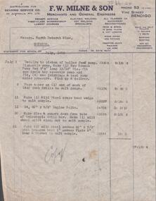
Document - NORTH DEBORAH G. M. CO. N. L. - STATEMENT TO NORTH DEBORAH G. M. CO. N. L. from F.W. Milne & Son
... ' of Vine Street, Bendigo and the name and types of goods... Engineers' of Vine Street, Bendigo and the name and types of goods ...Statement from F. W. Milne & Son, Merchants and General Engineers, Vine Street, Bendigo to North Deborah G. M. Co. N. L. Copy of statement for the month of July, 1958. Top of the page is printed with 'F.W. Milne & Son, Merchants and General Engineers' of Vine Street, Bendigo and the name and types of goods and services offered. Statement is for repair to boiler feed pump, turn taper on end of rock drills to suit sample, make a mild steel cross head wedge to suit sample, supply of bolts, make dies and remove dent from tube of telescopic drill bar, make mild steel split clamp nut to suit sample, make 2 mild steel screws 2 1/2'' x 5/8'' with hexagon head 1'' across flats 1/2'' long and thread to suit sample. Statement is a typed, carbon copy. It has copy written in pencil under the typing. Albert Richardson Collection. document, gold, north deborah g. m. co. n. l., north deborah g. m. co. n. l., statement to north deborah g. m. co. n. l., f w milne & son -
 Eltham District Historical Society Inc
Painting, The David Harbison Rest Home, 10 & 12 Arthur Street, Eltham
... which met at the Newsboys Society Hall in Little Collins Street... which met at the Newsboys Society Hall in Little Collins Street ...Notes by Jock Read who donated painting to the Society: “Site of present-day Eltham Mall The property was owned by a Mr David Harbison who was connected to one of the Melbourne daily newspapers who donated the property to the City Newsboys Society to be used as they required. The property consisted of two building blocks with one four roomed house known as the Cottage. The Secretary of the City Newsboys Society decided to use the property as a Rest Home for mothers of newsboys who needed a rest and could not afford a holiday. Miss Onians added another four roomed dwelling to the home which was known as the Bungalow. Another three roomed residence was erected at the rear of the cottage for the use of the Caretaker. The rear of the property was used as a camp area for the use of Troop of Boy Scouts known as the 13th Melbourne Troop which met at the Newsboys Society Hall in Little Collins Street. Later the name of the troop was changed to City Newsboys Troop who held their Christmas camps at Eltham and Hurstbridge alternating years. In 1930 the caretaker (Mr. Francis) became ill and resigned that position. I had been a member of the scout troop and offered the position as Honorary Caretaker which I held for eight years. The Homes were used regularly as such until the death of Miss Onians. It was sold later and used as private homes until the Eltham Mall was built.” Further research has determined that apparently, Harbison left £1,000 in his will for the City Newsboys Society and the Secretary, Miss Edith Onians built the rest home from these funds. It was opened on November 12, 1919. David Harbison Rest Home, Jock Read, City Newsboys Society, 13th Melbourne Troop, Boy Scouts, City Newsboys Troop, Miss Onions, Mr Francis, Arthur Street, Eltham, Eltham Mall, David HarbisonN.D. 16 x 36 cm Oil on Masonite board UnsignedInscribed on back "The David Harbison Rest Home 10 & 12 Arthur St. Eltham" -
 Eltham District Historical Society Inc
Photograph, Looking north across the Fitzsimons Lane Bridge over Yarra River between Eltham and Templestowe, c.1985, 1985c
... of Bolton Street was named Templestowe Road, December 15, 1970... of Bolton Street was named Templestowe Road, December 15, 1970 ...Turnoff to Candlebark Park on right. The bridge over the Yarra River was initially opened September 22nd, 1961. Newspaper reports at the time of opening stated it linked Bolton Street, Eltham, with Fitzsimons Lane, Templestowe. In 1955 the Country Roads Board (CRB) produced survey plans that showed proposed land acquisition for the future bridge and road approaches. The 1955 plan shows that it was proposed to connect Fitzsimons Lane with Bolton Street in Eltham by a diagonal road across the river. The road connection would then continue along Bolton Street to Main Road. Prior to construction of the bridge the CRB modified the proposal significantly so that there was a new road parallel with Bolton Street and then curving to join Main Road at what was then its intersection with Old Eltham Road. This involved significantly more land acquisition and altered the pattern of land subdivision through this corridor. Initially the new road was just a single two-way carriageway as it would have required a significant widening of the cutting on the Shire of Eltham side of the river. The road was officially un-named but was known locally as the Eltham-Templestowe Road. The 1966 Melway street directory and other 1960s editions also listed the road as the Eltham-Templestowe Road. In December 1970, Eltham Shire Council, in pursuance of the provisions of the Local Government Act, named it Templestowe Road. The road was renamed Fitzsimons Lane around 1984 in conformity with the section south of the river. In 1991 a new bridge was built to the west of the original bridge. Fitzsimons Lane was widened to four traffic lanes although on the Eltham side this was done within the limits of the existing cutting. NEW BRIDGE STARTS THEM EXPLORING Without any fanfares, Country Roads Board workmen on Friday afternoon put the finishing touches to the approaches, removed the barricades, and let the traffic roll over the new Yarra bridge linking Bolton Street, Eltham, with Fitzsimons Lane, Templestowe. Over the week-end many “bridge watchers” who were making one of their periodic inspections of the progress on the new bridge found to their surprise that they could drive over it, so that people who had gone for a run out to Eltham suddenly found themselves wandering through Templestowe and Doncaster. By Monday the word of the bridge’s opening had got around sufficiently for many regular travellers to the city from Eltham and beyond to vary the monotony by going to town via Templestowe and Kew instead of through Heidelberg. They were surprised at the distances – about 3 ½ miles from Eltham to Templestowe, 6 miles from Eltham Shire hall to the Lower Heidelberg Road-Banksia Street intersection. NEW NEIGHBOURS For people on both sides of the river, the new bridge has turned distant friends into near neighbours. A Greensborough man on Sunday took 35 minutes to reach the home of a friend in East Doncaster, but the return trip over the new bridge took only 17 minutes. It will be some time yet before most people work out the possibilities in shorter and quicker trips form the north-eastern areas to the eastern and south-eastern suburbs. The coming of the warmer months will soon teach many, though the short cuts to Peninsular beaches and eastern suburban drive-ins. And before very long it is likely there will be a Tramways bus running from Templestowe to Eltham station. NEW BRIDGE STARTS THEM EXPLORING (1961, September 27). The Diamond Valley News (News clipping held in SEA_74-1_047) The previously un-named road between Main Road and Yarra River, Eltham South, east of Bolton Street was named Templestowe Road, December 15, 1970 NAMING OF STREETS AND ROADS. (1970, December 15). The Diamond Valley News (News clipping held in SEA_74-2_022)Colour photographinfrastructure, shire of eltham infrastructure, bridge, fitzsimons lane bridge, yarra river, candlebark park, red nose day -
 Eltham District Historical Society Inc
Photograph, Fitzsimons Lane Bridge over Yarra River between Eltham and Templestowe
... of Bolton Street was named Templestowe Road, December 15, 1970... of Bolton Street was named Templestowe Road, December 15, 1970 ...The bridge over the Yarra River was initially opened September 22nd, 1961. Newspaper reports at the time of opening stated it linked Bolton Street, Eltham, with Fitzsimons Lane, Templestowe. In 1955 the Country Roads Board (CRB) produced survey plans that showed proposed land acquisition for the future bridge and road approaches. The 1955 plan shows that it was proposed to connect Fitzsimons Lane with Bolton Street in Eltham by a diagonal road across the river. The road connection would then continue along Bolton Street to Main Road. Prior to construction of the bridge the CRB modified the proposal significantly so that there was a new road parallel with Bolton Street and then curving to join Main Road at what was then its intersection with Old Eltham Road. This involved significantly more land acquisition and altered the pattern of land subdivision through this corridor. Initially the new road was just a single two-way carriageway as it would have required a significant widening of the cutting on the Shire of Eltham side of the river. The road was officially un-named but was known locally as the Eltham-Templestowe Road. The 1966 Melway street directory and other 1960s editions also listed the road as the Eltham-Templestowe Road. In December 1970, Eltham Shire Council, in pursuance of the provisions of the Local Government Act, named it Templestowe Road. The road was renamed Fitzsimons Lane around 1984 in conformity with the section south of the river. In 1991 a new bridge was built to the west of the original bridge. Fitzsimons Lane was widened to four traffic lanes although on the Eltham side this was done within the limits of the existing cutting. NEW BRIDGE STARTS THEM EXPLORING Without any fanfares, Country Roads Board workmen on Friday afternoon put the finishing touches to the approaches, removed the barricades, and let the traffic roll over the new Yarra bridge linking Bolton Street, Eltham, with Fitzsimons Lane, Templestowe. Over the week-end many “bridge watchers” who were making one of their periodic inspections of the progress on the new bridge found to their surprise that they could drive over it, so that people who had gone for a run out to Eltham suddenly found themselves wandering through Templestowe and Doncaster. By Monday the word of the bridge’s opening had got around sufficiently for many regular travellers to the city from Eltham and beyond to vary the monotony by going to town via Templestowe and Kew instead of through Heidelberg. They were surprised at the distances – about 3 ½ miles from Eltham to Templestowe, 6 miles from Eltham Shire hall to the Lower Heidelberg Road-Banksia Street intersection. NEW NEIGHBOURS For people on both sides of the river, the new bridge has turned distant friends into near neighbours. A Greensborough man on Sunday took 35 minutes to reach the home of a friend in East Doncaster, but the return trip over the new bridge took only 17 minutes. It will be some time yet before most people work out the possibilities in shorter and quicker trips form the north-eastern areas to the eastern and south-eastern suburbs. The coming of the warmer months will soon teach many, though the short cuts to Peninsular beaches and eastern suburban drive-ins. And before very long it is likely there will be a Tramways bus running from Templestowe to Eltham station. NEW BRIDGE STARTS THEM EXPLORING (1961, September 27). The Diamond Valley News (News clipping held in SEA_74-1_047) The previously un-named road between Main Road and Yarra River, Eltham South, east of Bolton Street was named Templestowe Road, December 15, 1970 NAMING OF STREETS AND ROADS. (1970, December 15). The Diamond Valley News (News clipping held in SEA_74-2_022)Black and white photographinfrastructure, shire of eltham infrastructure, bridge, fitzsimons lane bridge, yarra river -
 Eltham District Historical Society Inc
Photograph, Looking south across the Fitzsimons Lane Bridge over Yarra River between Eltham and Templestowe
... of Bolton Street was named Templestowe Road, December 15, 1970... of Bolton Street was named Templestowe Road, December 15, 1970 ...The bridge over the Yarra River was initially opened September 22nd, 1961. Newspaper reports at the time of opening stated it linked Bolton Street, Eltham, with Fitzsimons Lane, Templestowe. In 1955 the Country Roads Board (CRB) produced survey plans that showed proposed land acquisition for the future bridge and road approaches. The 1955 plan shows that it was proposed to connect Fitzsimons Lane with Bolton Street in Eltham by a diagonal road across the river. The road connection would then continue along Bolton Street to Main Road. Prior to construction of the bridge the CRB modified the proposal significantly so that there was a new road parallel with Bolton Street and then curving to join Main Road at what was then its intersection with Old Eltham Road. This involved significantly more land acquisition and altered the pattern of land subdivision through this corridor. Initially the new road was just a single two-way carriageway as it would have required a significant widening of the cutting on the Shire of Eltham side of the river. The road was officially un-named but was known locally as the Eltham-Templestowe Road. The 1966 Melway street directory and other 1960s editions also listed the road as the Eltham-Templestowe Road. In December 1970, Eltham Shire Council, in pursuance of the provisions of the Local Government Act, named it Templestowe Road. The road was renamed Fitzsimons Lane around 1984 in conformity with the section south of the river. In 1991 a new bridge was built to the west of the original bridge. Fitzsimons Lane was widened to four traffic lanes although on the Eltham side this was done within the limits of the existing cutting. NEW BRIDGE STARTS THEM EXPLORING Without any fanfares, Country Roads Board workmen on Friday afternoon put the finishing touches to the approaches, removed the barricades, and let the traffic roll over the new Yarra bridge linking Bolton Street, Eltham, with Fitzsimons Lane, Templestowe. Over the week-end many “bridge watchers” who were making one of their periodic inspections of the progress on the new bridge found to their surprise that they could drive over it, so that people who had gone for a run out to Eltham suddenly found themselves wandering through Templestowe and Doncaster. By Monday the word of the bridge’s opening had got around sufficiently for many regular travellers to the city from Eltham and beyond to vary the monotony by going to town via Templestowe and Kew instead of through Heidelberg. They were surprised at the distances – about 3 ½ miles from Eltham to Templestowe, 6 miles from Eltham Shire hall to the Lower Heidelberg Road-Banksia Street intersection. NEW NEIGHBOURS For people on both sides of the river, the new bridge has turned distant friends into near neighbours. A Greensborough man on Sunday took 35 minutes to reach the home of a friend in East Doncaster, but the return trip over the new bridge took only 17 minutes. It will be some time yet before most people work out the possibilities in shorter and quicker trips form the north-eastern areas to the eastern and south-eastern suburbs. The coming of the warmer months will soon teach many, though the short cuts to Peninsular beaches and eastern suburban drive-ins. And before very long it is likely there will be a Tramways bus running from Templestowe to Eltham station. NEW BRIDGE STARTS THEM EXPLORING (1961, September 27). The Diamond Valley News (News clipping held in SEA_74-1_047) The previously un-named road between Main Road and Yarra River, Eltham South, east of Bolton Street was named Templestowe Road, December 15, 1970 NAMING OF STREETS AND ROADS. (1970, December 15). The Diamond Valley News (News clipping held in SEA_74-2_022)Black and white photographinfrastructure, shire of eltham infrastructure, bridge, fitzsimons lane bridge, yarra river -
 Eltham District Historical Society Inc
Photograph, Fitzsimons Lane Bridge over Yarra River between Eltham and Templestowe
... of Bolton Street was named Templestowe Road, December 15, 1970... of Bolton Street was named Templestowe Road, December 15, 1970 ...The bridge over the Yarra River was initially opened September 22nd, 1961. Newspaper reports at the time of opening stated it linked Bolton Street, Eltham, with Fitzsimons Lane, Templestowe. In 1955 the Country Roads Board (CRB) produced survey plans that showed proposed land acquisition for the future bridge and road approaches. The 1955 plan shows that it was proposed to connect Fitzsimons Lane with Bolton Street in Eltham by a diagonal road across the river. The road connection would then continue along Bolton Street to Main Road. Prior to construction of the bridge the CRB modified the proposal significantly so that there was a new road parallel with Bolton Street and then curving to join Main Road at what was then its intersection with Old Eltham Road. This involved significantly more land acquisition and altered the pattern of land subdivision through this corridor. Initially the new road was just a single two-way carriageway as it would have required a significant widening of the cutting on the Shire of Eltham side of the river. The road was officially un-named but was known locally as the Eltham-Templestowe Road. The 1966 Melway street directory and other 1960s editions also listed the road as the Eltham-Templestowe Road. In December 1970, Eltham Shire Council, in pursuance of the provisions of the Local Government Act, named it Templestowe Road. The road was renamed Fitzsimons Lane around 1984 in conformity with the section south of the river. In 1991 a new bridge was built to the west of the original bridge. Fitzsimons Lane was widened to four traffic lanes although on the Eltham side this was done within the limits of the existing cutting. NEW BRIDGE STARTS THEM EXPLORING Without any fanfares, Country Roads Board workmen on Friday afternoon put the finishing touches to the approaches, removed the barricades, and let the traffic roll over the new Yarra bridge linking Bolton Street, Eltham, with Fitzsimons Lane, Templestowe. Over the week-end many “bridge watchers” who were making one of their periodic inspections of the progress on the new bridge found to their surprise that they could drive over it, so that people who had gone for a run out to Eltham suddenly found themselves wandering through Templestowe and Doncaster. By Monday the word of the bridge’s opening had got around sufficiently for many regular travellers to the city from Eltham and beyond to vary the monotony by going to town via Templestowe and Kew instead of through Heidelberg. They were surprised at the distances – about 3 ½ miles from Eltham to Templestowe, 6 miles from Eltham Shire hall to the Lower Heidelberg Road-Banksia Street intersection. NEW NEIGHBOURS For people on both sides of the river, the new bridge has turned distant friends into near neighbours. A Greensborough man on Sunday took 35 minutes to reach the home of a friend in East Doncaster, but the return trip over the new bridge took only 17 minutes. It will be some time yet before most people work out the possibilities in shorter and quicker trips form the north-eastern areas to the eastern and south-eastern suburbs. The coming of the warmer months will soon teach many, though the short cuts to Peninsular beaches and eastern suburban drive-ins. And before very long it is likely there will be a Tramways bus running from Templestowe to Eltham station. NEW BRIDGE STARTS THEM EXPLORING (1961, September 27). The Diamond Valley News (News clipping held in SEA_74-1_047) The previously un-named road between Main Road and Yarra River, Eltham South, east of Bolton Street was named Templestowe Road, December 15, 1970 NAMING OF STREETS AND ROADS. (1970, December 15). The Diamond Valley News (News clipping held in SEA_74-2_022)Black and white photographinfrastructure, shire of eltham infrastructure, bridge, fitzsimons lane bridge, yarra river