Showing 4045 items
matching survey
-
 Bendigo Military Museum
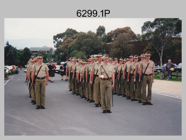
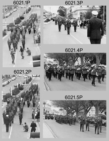
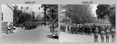
Photograph - Army Survey Regiment Guard of Honour, Russell Offices, Canberra, 1995
This set of 11 colour photographs of a Ceremonial Guard of Honour from the Army Survey Regiment was most likely taken at Russell Offices, Canberra in 1995. Most Guard of Honour detachments sent to Canberra performed the ceremony in the Blamey Square at Defence’s Russell Offices precinct. An identification label in the storage folder identified the parade was at an Australia Remembers 1945-1995 event, one of many activities designed to commemorate and celebrate the 50th anniversary of the end of the Second World War on 15 August 1945.This set of 11 colour photographs of a Ceremonial Guard of Honour from the Army Survey Regiment was most likely taken at Russell Offices, Canberra in 1995. The photographs were printed on photographic paper and are part of the Army Survey Regiment’s Collection. The photographs were scanned at 300 dpi. .1) & .2) - Photo, colour, 1995. L to R: Right file – No 1: SPR Cameron Gee, No 2: SPR Shane Campbell, No 3: CPL Andrew Quin, No: 4 SPR Ken Labouchardiere, No 10: SPR Lance Hillier, remainder unidentified. Parade formation commander: LT Jason Selman, Centre file – front No 1: CPL Ian Bowes, No 3: CPL Chris Wynn, No 4: SPR Mick Muzeen, No 5: SPR Julie Gretton, No 6: CPL Ken Peters, No 7: SPR Allison Ottaway, No 9: CPL Hamish Goetz, No 11: SGT Darren Wilkinson, remainder unidentified. Left file – No 2: SPR James Commons, No 3: SPR Matt White, No 4: CPL Andrew Lazdovskis, No 6: SPR Michelle Withers, No 7: CPL Greg Howell, remainder unidentified. .3) - Photo, colour, 1995. Front rank L to R: SPR Lance Hillier, CPL Dave Scott, SPR Andrew Arman, unidentified, SPR Mick Muzeen, CPL Darren Scott, SPR Ken Labouchardiere, CPL Andrew Quin, SPR Shane Campbell, SPR Cameron Gee. Parade formation commander: LT Jason Selman. Centre rank L to R: unidentified (x2), CPL John Commons, SPR Allison Ottaway, unidentified (x3), CPL Chris Wynn, unidentified (x2.) Rear rank L to R: unidentified (x3), CPL Greg Howell, unidentified, SPR Helen Scorgie, CPL Andrew Lazdovskis, unidentified (x3). .4) to .6) - Photo, colour, 1995. All unidentified. .7) & .8) - Photo, colour, 1995. L to R: LTCOL Duncan Burns, Parade formation commander: LT Jason Selman, COL COMDT COL Don Swiney MBE, unidentified dignitary. Front rank L to R: SPR Lance Hillier, CPL Dave Scott, SPR Andrew Arman, unidentified, SPR Mick Muzeen, CPL Darren Scott, SPR Ken Labouchardiere, CPL Andrew Quin, SPR Shane Campbell, SPR Cameron Gee. Centre rank L to R: unidentified, CPL Chris Wynn, unidentified. CPL Ian Bowes, Rear rank L to R: CPL Greg Howell, SPR Helen Scorgie, CPL Andrew Lazdovskis, SGT Darren Wilkinson. .9) - Photo, colour, 1995. L to R: CPL Ian Bowes, LTCOL Duncan Burns, Parade formation commander: LT Jason Selman, COL COMDT COL Don Swiney MBE, unidentified dignitary, unidentified (x3), SPR Michelle Withers, SPR Helen Scorgie, unidentified, SPR Matt White, SPR James Commons, unidentified. .10) - Photo, colour, 1995. L to R: CPL Ian Bowes, Parade formation commander: LT Jason Selman, unidentified dignitary, COL COMDT COL Don Swiney MBE (partly obscured), unidentified (x3), SPR Michelle Withers, SPR Helen Scorgie, unidentified, SPR Matt White, SPR James Commons, unidentified. .11) - Photo, colour, 1995. L to R: CPL Ian Bowes, Parade formation commander: LT Jason Selman, COL COMDT COL Don Swiney MBE, unidentified dignitary, Matt White, SPR James Commons, unidentified, SGT Darren Wilkinson.Identification label ‘RASvy Guard of Honour – Australia Remembers 1945-1995’. No personnel identified.royal australian survey corps, army survey regiment, army svy regt, rasvy, fortuna, asr -
 Bendigo Military Museum
Album - Army Survey Regiment - Litho Sqn Photo Album 1978 and 1990's, Litho Sqn, Army Survey Regiment, Bendigo, Circa 1990's
This is an Army Survey Regiment - Lithographic Squadron Photo Album containing black and white and colour photos of Litho Sqn personnel and equipment taken at various occasions in 1978 and 1990's.Large handmade photo album, green cardboard cover, plywood backing, timber and Chicago screw binding. Containing numerous photos colour, black and white of various sizes."LITHO SQN Compiled Photo Album, 1978 and 1990's"royal australian survey corps, rasvy, fortuna, army survey regiment, army svy regt, asr -
 Bendigo Military Museum
Pamphlet - Manual of Land Warfare - Employment of RASvy - Survey Training, School of Military Survey, Bonegilla, Vic, 1984
This document is a draft proposal by the School of Military Survey (SMS) for the Manual of Land Warfare Volume 1, Phamphlet No1 - Employment of RASvy - Part 2, Survey Training 1984. The pamphlet describes the responsibilities and principles of employment of RASvy units and elements in the area of operations and in the support area. It outlines the roles, characteristics and tasks of RASvy units and elements, but no attempt has been made to detail staff or technical procedures. The document being a draft, contains many blank pages for additional information to be added prior to publication. RASvy was disbanded in 1996.45 x page A4 paper pamphlet containing text and diagrams. Buff coloured light card covers with a plastic comb binding.On the front cover: "A 7610 -14 - 1332" "As proposed by SMS April 1985"royal australian survey corps, rasvy, fortuna, army survey regiment, army svy regt, asr, school of military survey -
 Bendigo Military Museum
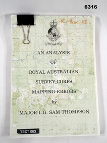
Administrative record - An analysis of Royal Australian Survey Corps mapping errors by Major LG Sam Thompson, Major LG Sam Thompson US Army Corps of Engineers at Army Survey Regiment, circa 1978
The purpose of the report is to analyze and study the map making procedures at the Army Survey Regiment to quantify the accuracy of the mapping to see if they meet acceptable accuracy standards. This was achieved through the study of possible errors.A4 loose leaf booklet held together with a "bulldog" paper clip. Cover part of an a RASvy 1:50,000 map. 1x Cover, 7x Introductory pages, 103x report pages.Marked on front cover "X - Box - 13", "TEXT 063"royal australian survey corps, rasvy, fortuna, army survey regiment, army svy regt, asr -
 Bendigo Military Museum
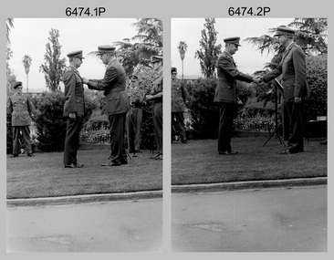
Photograph - 4th Field Survey Squadron OC’s Parades and Defence Force Service Medal Presentations, Keswick Barracks, Adelaide SA, 1986
This is a set of 27 photographs of a 4th Field Survey Squadron OC’s parade at Keswick Barracks, Adelaide SA in 1986. The OC - MAJ Don Taylor presented the Defence Force Service Medal to personnel in recognition of 15 years of efficient remunerated service, or the Clasp for 5 years of additional service. Photos .22P to .27P were taken on a separate OC’s Parade. OC MAJ Don Taylor is seen in photo .27P congratulating WO2 Russell ‘Rusty Williams, probably on his promotion to WO1. This is a set of 27 photographs of a 4th Field Survey Squadron OC’s parade and the presentation of the Defence Force Service Medal, at Keswick Barracks, Adelaide SA in 1986. The colour photographs are on 35mm negative film and are part of the Army Survey Regiment’s Collection. The photographs were scanned at 96 dpi. .1) - Photo, colour, 1986. L to R: WO2 Gary Warnest in background, SPR Steve Ellis, CPL John Ratcliffe, SPR John Keely. .2) - Photo, colour, 1986. L to R: CPL Jeff Prince, SPR Bruce Graham, SGT Stuart Symonds, CPL John Ratcliffe, SGT Peter Imeson. .3) - Photo, colour, 1986. 4 Fd Svy Sqn at ease. Centre rank L to R: SPR Steve Wainwright, CPL Jeff Prince, CPL Peter Hardy. Front rank L to R: SPR Todd Hayley, SPR Steve Ellis, CPL Dave Irving, SPR Richard Cocker, SPR Damien Killeen, remainder unidentified. .4) to .6) - Photo, colour, 1986. Parade handover L to R: SSM WO1 Bill Griggs, 2IC CAPT Steve Cooper. .7) - Photo, colour, 1986. Parade handover L to R: 2IC CAPT Steve Cooper, OC MAJ Don Taylor. .8) - Photo, colour, 1986. Parade handover L to R: OC MAJ Don Taylor, 2IC CAPT Steve Cooper. .9) - Photo, colour, 1986. Inspection L to R: CPL Jeff Prince, CPL John Ratcliffe, CPL Peter Hardy, OC MAJ Don Taylor, 2IC CAPT Steve Cooper, SSM WO1 Bill Griggs. .10) - Photo, colour, 1986. Inspection L to R: WO2 Gary Warnest, WO2 Bob Rogister, WO2 Russell ‘Rusty' Williams, OC MAJ Don Taylor, SSM WO1 Bill Griggs, SGT Wally Chilcott. .11) - Photo, colour, 1986. Inspection L to R: WO2 P. Symmans, WO2 Gary Warnest, 2IC CAPT Steve Cooper, OC MAJ Don Taylor, SGT Wally Chilcott. .12) & .13 - Presentations L to R: SPR Simon Reynolds, OC MAJ Don Taylor. .14) & .15) - Photo, colour, 1986. Presentations: SSM WO1 Bill Griggs. .16) & .17) - Photo, colour, 1986. Presentations L to R: WO2 Russell ‘Rusty' Williams, OC MAJ Don Taylor, SPR Simon Reynolds. .18) - Photo, colour, 1986. Presentations: WO2 Russell ‘Rusty' Williams. .19) - Photo, colour, 1986. Presentations L to R: unidentified (x2), CPL Terry ‘TJ’ Wicker. .20) - Photo, colour, 1986. Presentations L to R: CPL Terry ‘TJ’ Wicker, OC MAJ Don Taylor, SPR Simon Reynolds, 2IC CAPT Steve Cooper. .21) - Photo, colour, 1986. Presentations L to R: CPL Terry ‘TJ’ Wicker, OC MAJ Don Taylor. 22) & .23) - Photo, colour, 1986. Parade right dress. Centre rank L to R: SPR Steve Wainwright, SPR Peter Tuddenham, CPL Jeff Prince, remainder unidentified. Front rank L to R: SPR Todd Hayley, CPL Chris ‘Charlie’ Brown, SPR Richard Cocker, unidentified, SPR Steve Nokes, CPL Dave Irving, SPR Steve Ellis remainder unidentified. .24) - Photo, colour, 1986. Presentations L to R: SPR Simon Reynolds, 2IC CAPT Steve Cooper, OC MAJ Don Taylor, CPL Dave Longbottom. .25) - Photo, colour, 1986. Presentations: CPL John Ratcliffe. .26) - Photo, colour, 1986. Presentations L to R: CPL John Ratcliffe, WO2 Russell ‘Rusty' Williams. .27) - Photo, colour, 1986. Presentations L to R: SPR Steve Ellis, unidentified, WO2 Russell ‘Rusty' Williams, SSM WO1 Bill Griggs, OC MAJ Don Taylor..1P to .27P – There are no personnel identified. ‘1986 Presentations’ annotated on negatives sleeve.royal australian survey corps, rasvy, 4 fd svy sqn -
 Bendigo Military Museum
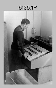
Photograph - Print Troop – Lithographic Squadron – Army Survey Regiment, Fortuna, Bendigo
This collection of 23 photos was most likely taken in Lithographic Squadron, Army Survey Regiment, Fortuna, Bendigo, in 1988. In photos .1P and .2P the technician is preparing a Chromalin map proof for supporting information that would be printed on the reverse side of a topographic map. This map was commonly referred to as a ‘snack’ map, with photos of edible indigenous plants and descriptions endemic to that region printed on the reverse side to assist soldiers living off the land in survival situations. The authoritative information was provided by Major Leslie James (Les) Hiddins aka ‘the Bush Tucker Man’ He is a retired Australian Army soldier and war veteran, who is best known for his love and knowledge of the Australian bush. See item 6190.6P for more information on the Chomalin proof production process. In the remaining photos, Print Troop’s technicians were most likely operating the Komoni, Planeta or Ultra-MAN-III offset printing presses, as well as working in the map despatch dock. Although these photos are not annotated most personnel are positively identified. This is a set of 23 photographs of Print Troop personnel and equipment from Lithographic Squadron at the Army Survey Regiment, Fortuna, Bendigo, 1988. The photographs were on 35mm negative film and were scanned at 96 dpi. They are part of the Army Survey Regiment’s Collection. .1) - Photo, black & white, 1988, Chromalin Proof laminating, Terry King. .2) - Photo, black & white, 1988, Chromalin Proof laminating, Terry King. .3) to .6) - Photo, black & white, 1988, Ultra-MAN-III Printing Press, Colin Yeats. .7) - Photo, black & white, 1988, Ultra-MAN-III Printing Press, L to R: Greg Rowe, SPR Mark ‘Dogs’ Doherty. .8) - Photo, black & white, 1988, Ultra-MAN-III Printing Press, SPR Mark ‘Dogs’ Doherty. .9) to .10) - Photo, black & white, 1988, Ultra-MAN-III Printing Press, John Bateman. .11) - Photo, black & white, 1988, Ultra-MAN-III Printing Press. .12) - Photo, black & white, 1988, Map laminator? L to R: SGT Dale Hudson, SGT Gary Kerr. .13) - Photo, black & white, 1988, Newkoni Komori Printing Press, Peter Hamilton. .14) to .17) - Photo, black & white, 1988, Original Heidelberg Printing Press, Peter Hamilton. .18) to .19) - Photo, black & white, 1988, Map Despatch area, SPR Steve Wright. .20) - Photo, black & white, 1988, Map Despatch area, L to R: unidentified, SGT Gary Kerr. .21) - Photo, black & white, 1988, Printing Presses - foreground: Ultra-MAN-III (x2), centre: Newkoni Komori and background: Planeta Polygraph. .22) - Photo, black & white, 1988, Ultra-MAN-III Printing Presses (x2). .23) - Photo, black & white, 1988, L to R: Daryl South, Mark McCulloch.No personnel are identifiedroyal australian survey corps, rasvy, army survey regiment, army svy regt, fortuna, asr, litho, printing -
 Bendigo Military Museum
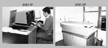
Photograph - Personnel and Equipment, Army Survey Regiment, Fortuna, Bendigo. c1979, c1979
This is a set of 23 photographs of cartographic, aero-triangulation and lithographic equipment, and personnel at the Army Survey Regiment, Fortuna, Bendigo circa 1979. Photos .8P to .23P were taken in Lithographic Squadron’s printing, Camera, proofing rooms and external buildings. Cartographic Squadron’s SGT Jim McDonald operated the Editwriter type setting machine, as shown in photo .2P for a couple years in a room on the top floor of Fortuna Villa. This is a set of 23 photographs of cartographic, aero-triangulation and lithographic equipment, and personnel at the Army Survey Regiment, Fortuna, Bendigo, c1979. Black and white photos are on photographic paper and mounted on manilla card. They were scanned at 300 dpi. .1) - Photo, black & white, c1979, Typesetting machine, ‘Editwriter’ Model 7500, SGT Jim McDonald. .2) - Photo, black & white, c1979, Processor Model ACP101 & dual disk module (attached to Editwriter). .3) - Photo, black & white, c1979, Duplicating machine, stencil process electric ‘Gestetner’. .4) - Photo, black & white, c1979, Comparator photogrammetric stecometer, modified ‘Carl Zeiss’, CPL Jack Elverd. .5) - Photo, black & white, c1979, Point transfer device ‘Wild PUG IV. .6) - Photo, black & white, c1979, Zoom transfer scope, stereo ‘Bausch & Lomb’ .7) - Photo, black & white, c1979, Stereoplotter analytical automatic, ‘APC/3-1’. .8) - Photo, black & white, c1979, Prophylaxis unit, ‘Densply/Cavtron’ .9) - Photo, black & white, c1979, Machine punch register (made by Bendigo Ordnance Factory). .10) - Photo, black & white, c1979, Plan printer 122cm (48”) wide. ‘Admel Bruning’ Model - 5003A. .11) - Photo, black & white, c1979, Metal halide printing lamp. ‘Violight 5000 HV’ .12) - Photo, black & white, c1979, Densitometer transmission or reflection, ‘Macbeth’ Model – TR 524 MD. .13) - Photo, black & white, c1979, Machine whirling vertical type ‘Payne VLW’. .14) - Photo, black & white, c1979, Densitometer reflection, ‘Macbeth’ Model – RD917. .15) - Photo, black & white, c1979, Densitometer reflection, 240V ‘Cosar’ .16) - Photo, black & white, c1979, Printer contact ‘Hohlux’ Model RP-II, LCPL Martin Van der Maele. .17) - Photo, black & white, c1979, Frame printing vacuum vertical. .18) - Photo, black & white, c1979, Frame printing vacuum flip top 91cm x 117cm. .19) - Photo, black & white, c1979, Printer reduction stereo plotter diapositive ‘Wild’ Model – U3A modified and U4A modified to U4A plus. .20) - Photo, black & white, c1979, Printing press offset rotary lithographic 3 colour ‘Ultra-MAN-III’ .21) to. 23) - Photo, black & white, c1979, Camera cartographic consolidated super 100 32” x 32”The three personnel appearing in this set are identified. Most items have a full description, NSN, serial number, and the Repairer’s name, address and phone details and contact name. Just the full description is documented.royal australian survey corps, rasvy, army survey regiment, army svy regt, fortuna, asr -
 Bendigo Military Museum
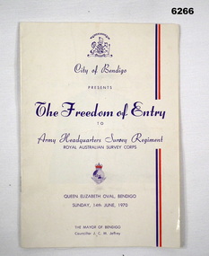
Booklet - City of Greater Bendigo Presents "The Freedom of Entry to Army Headquarters Survey Regiment", Army Headquarters Survey Regiment, 14.06.1970
This booklet is the program for the AHQ Survey Regiment Freedom of Entry to Bendigo on Sunday 14 Jun 1970 held at the Queen Elizabeth Oval, Bendigo. The ceremony was officiated by the Mayor of Bendigo Councillor CM JeffreyBooklet, B4 size, 11 pages, semi gloss paper, cover, red and blue text, contents, photos and text.army survey regiment, army svy regt, fortuna, royal australian survey corps, rasvy, asr -
 Bendigo Military Museum
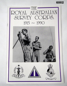
Booklet - Booklet Royal Australian Survey Corps History, " The Royal Australian Survey Corps " 1915-1990, c, 1995
This article was presented as a paper to the 1990 Australian War Memorial History Conference to mark the 75th anniversary of the formation of the "Australian Survey Corps" on 1 July 1915. The Corps has since been renamed. Booklet, A4, 13 Pages, Cardboard Cover, Colour, Maps, Photographs, Black and White. Held together by metal staplesroyal australian survey corps, rasvy, fortuna, army survey regiment, army svy regt, asr -
 Greensborough Historical Society
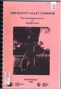
Book, Victoria Archaeological Survey, The Plenty Valley Corridor: the archaeological survey of Aboriginal sites / by Isabel Ellender 1989, 1989_
This archaeological survey of th Plenty Valley was conducted by Isabel Ellender in 1989 for the Ministry of Planning and Environment. The area studied is north of Greensborough to Whittlesea. A number of Aboriginal sites were identified and recommendations made for the future.103 p., illus., maps. Plastic spiral binding.plenty river, aboriginal heritage sites -
 Bendigo Military Museum
Photograph - Lithographic Squadron Group Photos, Army Survey Regiment, Fortuna Villa, Bendigo, 1990
This is a set of 15 photographs of personnel posted to Lithographic Squadron at the Army Survey Regiment, Fortuna Villa, Bendigo Victoria, on the 1st of October 1990. These informal and formal group photos were taken on the day of a CO’s Parade. It is not known why sunglasses were worn at the Squadron parade outside the Litho huts. Photos of the other three Squadrons, the Officers, and Warrant Officers/Sergeants from this set of negatives are catalogued in item 6440.11P. This is a set of 15 photographs of personnel posted to Lithographic Squadron at the Army Survey Regiment, Fortuna Villa, Bendigo Victoria, on the 1st of October 1990. The photographs are on 35mm negative film and were scanned at 96 dpi. They are part of the Army Survey Regiment’s Collection. .1) &.2) - Photo, black & white, 1990. OC MAJ Bob Coote. .3) - Photo, black & white, 1990. Front rank L to R: SPR Ken Labouchardiere, SPR Doug Whiteside, SPR Mark McCullogh. Centre rank L to R: SPR Andrew Woodman. Rear rank L to R: CPL Geoff Webb, CPL Daryl South. .4) - Photo, black & white, 1990. Front rank L to R: SSGT Russ Mollenhauer, SGT Kim Reynolds, SGT Brian Paul, unidentified, SPR Ken Labouchardiere, SPR Doug Whiteside, Centre rank L to R: SPR Graeme Spong, SPR Andrew Woodman. Rear rank L to R: SGT Steve Burke, CPL Geoff Webb. .5) - Photo, black & white, 1990. WO1 Trevor Osborne. .6) - Photo, black & white, 1990. LCPL Damien Cole. .7) - Photo, black & white, 1990. L to R: WO2 Rhys De Laine, WO2 Steve Egan, WO2 Keith Fenton RE UK Exchange, WO2 Rob Bogumil, WO1 Bill Jones. .8) - Photo, black & white, 1990. L to R: SPR Shane ‘Smily’ Campbell, SPR Andrew Woodman, CPL Daryl South. .9) - Photo, black & white, 1990. LT Greg Tolcher. .10) - Photo, black & white, 1990. SGT Steve Burke. .11) - Photo, black & white, 1990. Lithographic Squadron: Back row L to R: SPR Ross Anza, SGT Brian Fauth, unidentified, SPR Andrew Arman, SGT Gary Kerr, SPR Doug Whiteside, SSGT Russ Mollenhauer, CPL Peter Swandale, CPL Roy Hicks, SPR Shane ‘Smily’ Campbell, SPR Graeme Spong. Jones. 3rd row L to R: SSGT Garry Drummond, SGT Kim Reynolds, unidentified, SGT Brian Paul, CPL Gavin Mclean, SPR Mark McCullogh, CPL Le-Anne (Smallshaw) Shirley, CPL Geoff Webb, SPR Gary Lord, SSGT Di Chalmers, CPL Peter Dillon, LCPL Damien Cole, SGT Steve Burke. 2nd row L to R: SSGT Peter Imeson, SPR Gary Sievers, unidentified, CPL Daryl South, SPR Greg Howell, SPR Janet Murray, SPR Michelle Withers, SPR Ken Labouchardiere, SPR John Bragg, SPR Andrew Morrison-Evans, CPL John ‘Flash’ Anderson, CPL Trevor King. Front row L to R: WO2 Steve Egan, WO1 Trevor Osborne, LT Greg Tolcher, WO2 Rob Bogumil (standing), OC MAJ Bob Coote, LT Marty Lyons, WO2 Rhys De Laine, WO2 Keith Fenton RE UK Exchange, WO2 Jeff Willey. .12) & .13) - Photo, black & white, 1990. Lithographic Squadron: Back row L to R: SPR Ross Anza, SGT Brian Fauth, unidentified, SPR Andrew Arman, SGT Gary Kerr, SPR Doug Whiteside, SSGT Russ Mollenhauer, CPL Peter Swandale, CPL Roy Hicks, SPR Shane ‘Smily’ Campbell, SPR Graeme Spong. Jones. 3rd row L to R: SSGT Garry Drummond, SGT Kim Reynolds, unidentified, SGT Brian Paul, CPL Gavin Mclean, SPR Mark McCullogh, CPL Le-Anne (Smallshaw) Shirley, CPL Geoff Webb, SPR Gary Lord, SSGT Di Chalmers, CPL Peter Dillon, LCPL Damien Cole, SGT Steve Burke. 2nd row L to R: SSGT Peter Imeson, SPR Gary Sievers, unidentified, CPL Daryl South, SPR Greg Howell, SPR Janet Murray, SPR Michelle Withers, SPR Ken Labouchardiere, SPR John Bragg, SPR Andrew Morrison-Evans, CPL John ‘Flash’ Anderson, CPL Trevor King. Front row L to R: WO2 Steve Egan, WO1 Trevor Osborne, LT Greg Tolcher, WO2 Rob Bogumil, OC MAJ Bob Coote, LT Marty Lyons, WO1 Bill Jones, WO2 Rhys De Laine, WO2 Keith Fenton RE UK Exchange, WO2 Jeff Willey. .14) - Photo, black & white, 1990. L to R: WO2 Rob Bogumil, unidentified, OC MAJ Bob Coote, CPL Daryl South, unidentified (x3), CPL Roy Hicks, SSGT Di Chalmers, WO2 Jeff Willey, WO2 Keith Fenton RE UK Exchange, SPR Ken Labouchardiere, WO2 Rhys De Laine. .15) - Photo, black & white, 1990. L to R: SPR Greg Howell, SPR Gary Sievers, unidentified, SPR Ross Anza, unidentified (x4), SSGT Russ Mollenhauer, SPR Doug Whiteside, SGT Brian Paul, unidentified (x7), WO2 Jeff Willey, unidentified, WO2 Keith Fenton RE UK Exchange, WO2 Rhys De Laine, SPR Shane ‘Smily’ Campbell..1P to .15P – no annotationsroyal australian survey corps, rasvy, army survey regiment, army svy regt, fortuna, asr, litho sqn -
 Bendigo Military Museum
Photograph - Bones Day - Army Survey Regiment Versus RAAF School of Radio. Fortuna, Bendigo, c1982
These four photographs were taken at Bones Day, an annual sports competition between the Army Survey Regiment and the RAAF School of Radio at Bendigo c1982. The two units took turns each year to host the event. The day competition usually comprised basketball, cross country, golf, sailing, squash, softball, tennis, touch football, rifle shooting, tug-of-war and volleyball. The two sports featuring in these photos are touch football and tug-of-war. The “big bone” trophy comprising a large bone from a beast housed inside a wooden framed glass case, was awarded to the winner of the day competition. The evening competition often included darts, carpet bowls, hookey, quoits and billiards/snooker. The “little bone” (a mounted chicken bone) was the consolation trophy awarded to the winner of the evening competition. The 3-hour bus trip for the visiting unit on their return was typically very raucous. The history of the Bones Day competition is best described in the booklet titled - Bones of Contention Souvenir Program. 1965. Refer to Item 6267.These four photographs were taken at Bones Day, an annual sports competition between the Army Survey Regiment and the RAAF School of Radio at Bendigo c1982. The photographs are on 35mm negative film. They are part of the Army Survey Regiment’s Collection. The photographic negatives were scanned at 96 dpi. There are additional photos in this set that have not been scanned due to poor quality or low historical value. .1) - Photo, black & white, 1982, Touch Football Team Back Row L to R: Brian Fauth, Bruce Bowers, Bob Mason, Paul Baker, Danny Galbraith, John Hook, Scott Payne. Front Row L to R: Roy Hicks, Peter Imeson, Alan Glanville, John Gilbert, Wally Chilcott. .2) - Photo, black & white, 1982, Tug-of-War Team Back Row L to R: Cliff Webb, Peter Treble, John Lane, Andy Wilson, Rick Warren, Rusty Williams, Brian Paul. Front Row L to R: Brian Fauth, Rick Downie, unidentified, Ken Slater, Rhys De Laine, John Smith, unidentified. .3) - Photo, black & white, 1982, Tug-of-War Team L to R: Peter Treble, Brian Paul, Rusty Williams, Rhys De Laine, unidentified (2), John Smith. Army personnel in background standing L to R: Rick van der Bom, Paul Hopes, Ian Nelson, Mick Dempster, John ‘Flash’ Anderson, Geoff Havelberg, John ‘Stormy’ Tempest, Bruce Gordon, Dan Cirsky, Neil Jones, Gerry Gates, Peter Main, Bob Thrower, Barry Miller, Gill Park. Army personnel in background seated L to R: Roger Pearson, Mick Gillham, Penny Knott, Leanne Shirley. .4) - Photo, black & white, 1982, Tug-of-War Team L to R: Rick Warren, Cliff Webb, Andy Wilson, Peter Treble, Brian Paul, Rusty Williams, Rhys De Laine, unidentified. Army personnel in background standing L to R: Rick van der Bom, Ian Nelson, Mick Dempster. .1P to .4P – No personnel are identified.royal australian survey corps, rasvy, army survey regiment, army svy regt, fortuna, raaf school of radio, bones day -
 Marysville & District Historical Society
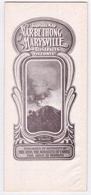
Map (Item) - Tourist Map, Department of Lands & Survey, Tourist's Map of Narbethong and Marysville Districts Victoria, 1913
A tourist map for the Narbethong and Marysville Districts that was originally produced by the Department of Lands & Survey in 1925.A tourist map for the Narbethong and Marysville Districts that was originally produced by the Department of Lands & Survey in 1925.Reprint of the 1925 Tourist brochure by permission R.E. Holmes Surveyor General By Authority: ALBERT J. MULLETT, Government Printer, Melbourne. Photo Lithographed at the Department of Lands and Survey Melbourne by W.J. Butson/ 26.8.13narbethong, marysville, victoria, department of lands & survey, the acheron valley, warburton, map, tourist map -
 Marysville & District Historical Society
Map (Item) - Tourist Map, Department of Lands & Survey, Tourist's Map of Narbethong and Marysville Districts Victoria, 1913
A tourist map for the Narbethong and Marysville Districts that was originally produced by the Department of Lands & Survey in 1925.A tourist map for the Narbethong and Marysville Districts that was originally produced by the Department of Lands & Survey in 1925.Reprint of the 1925 Tourist brochure by permission R.E. Holmes Surveyor General By Authority: ALBERT J. MULLETT, Government Printer, Melbourne. Photo Lithographed at the Department of Lands and Survey Melbourne by W.J. Butson/ 26.8.13narbethong, marysville, victoria, department of lands & survey, the acheron valley, warburton, map, tourist map -
 Bendigo Military Museum
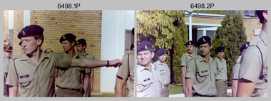
Photograph - Army Survey Regiment Freedom of Entry Parade, 1980
The Freedom of Entry to the City was an honour conferred by the Bendigo City Council to the Army Survey Regiment in 1970. 1980 was the third time the unit exercised its freedom of marching into the city with swords drawn, bayonets fixed and drums beating. The honour is usually bestowed upon local regiments, in recognition of their dedicated service, and it is common for military units to periodically exercise their freedom by arranging a parade through the city. Led by the Regiment’s CO – LTCOL Bob Skitch, the unit marched down View St in the CBD, along Pall Mall and up Gaol Rd to the Queen Elizabeth II Oval. The ceremonial parade followed with a march past the guests of honour, Mayor of Bendigo Councillor Paul Tomkinson and military dignitaries. The parade concluded after formal inspections of the troops. The Regiment also exercised its Freedom of Entry with anniversary parades in 1977, 1980, 1985, 1990 and 1995.These black and white photographs of the Army Survey Regiment were taken on the occasion of the Freedom of Entry parade to the City of Bendigo in 1980. The photographs were printed on photographic paper and are part of the Army Survey Regiment’s Collection. The photographs were scanned at 300 dpi. .1) Photo, black & white, L to R: MAJ Don Swiney, LTCOL Bob Skitch, WO1 Aub Harvey, unidentified, photographer in foreground – SGT Garran Hill .2) Photo, colour, black & white, L to R: MAJ Don Swiney, LTCOL Bob Skitch, WO1 Aub Harvey, unidentified .3) Photo, black & white, L to R: MAJ Don Swiney, WO1 Aub Harvey, LTCOL Bob Skitch, unidentified .4) Photo, black & white: 3rd MD Band .5) Photo, colour, L to R: MAJ Don Swiney, WO1 Aub Harvey, LTCOL Bob Skitch, unidentified .6) Photo, black & white, L to R: MAJ Don Swiney, WO1 Aub Harvey, unidentified, LTCOL Bob Skitch .7) Photo, black & white, L to R: SGT Stu Thaxter, LT Neil Taylor, CAPT Bob Roche .8) Photo, black & white, L to R: SPR Per Andersen – right marker .9) Photo, black & white, L to R: MAJ Peter Eddy .10) Photo, black & white, L to R: CPL Frank Lenane, CPL Flash Anderson, SGT Rhys De Laine, SPR Per Andersen .11) Photo, black & white, L to R: Mayor Paul Tomkinson .12) Photo, black & white, L to R: MAJ Don Swiney, WO1 Aub Harvey, unidentified, LTCOL Bob Skitch .13) Photo, black & white, L to R: unidentified personnel .14) Photo, black & white, L to R: unidentified personnel .15) Photo, black & white, L to R: unidentified personnel .16) Photo, black & white, L to R: unidentified personnel .18) Photo, black & white, L to R: CAPT Paddy Strunks, Mayor Paul Tomkinson, LTCOL Bob Skitch .19) Photo, black & white, L to R: Mayor Paul Tomkinson, CPL Bill Jones, CPL Gary Drummond, WO2 Tom Pattison .20) Photo, black & white, L to R: CAPT Paddy Strunks, WO1 Aub Harvey, Mayor Paul Tomkinson, SGT Rick Warren, CPL Andy Wilson …, WO2 Ted Burgess .21) Photo, black & white, L to R: LTCOL Bob Skitch, SPR Roy Hicks, Trevor Osborne, SPR Paul Baker, CAPT Stan Vote, CPL Bill Jones, Greg Francis-Wright .22) Photo, black & white, Air Survey Squadron inspection. Rear rank: SSGT Russell ‘Rusty’ Williams. Centre rank L to R: CPL Peter Treble, SGT Jim Beard, SPR Peter Hardy, SPR Steve Hilton, SPR John Lane, CPL Mick Hogan, Mayor – Councillor Paul Tomkinson. .23) Photo, black & white, L to R: Mayor Paul Tomkinson, CPL Marrianne (Van De Zee) De Groot, SPR Cathy Regan, SPR Ginny Turner, SPR Ilen Isaac, SPR Penny Knott, SPR Santina Argetto, SPR Gina Coore .24) Photo, black & white, L to R: Mayor Paul Tomkinson, SPR Cathy Regan, SPR Ginny Turner, SPR Ilen Isaac, SPR Penny Knott, SPR Santina Argetto, SPR Gina Coore, WO2 Pat Lumsden .25) Photo, black & white, L to R: LTCOL Bob Skitch, Mayor Paul Tomkinson, SPR Ilen Isaac, SPR Penny Knott, SPR Santina Argetto, SPR Gina Coore, WO2 Pat Lumsdenroyal australian survey corps, rasvy, fortuna, army survey regiment, army svy regt, asr -
 Bendigo Military Museum
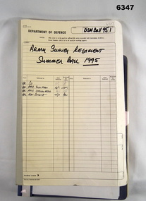
Administrative record - Army Survey Regiment Officers Mess Ball 1995, Army Survey Regiment, Bendigo, 1995
The Army Survey Regiment held Annual Balls at Fortuna Villa. This folder contains the documentation for the Logistics and activities associated with the planning and running of the Officers and Sergeants Mess Ball held in 1995. The folder also contains an after action review of the ball.Cloth bound manila Correspondence Folder containing minutes and correspondence for the Officers and Sergeants Mess Summer Ball of 1995royal australian survey corps, rasvy, fortuna, army survey regiment, army svy regt, asr -
 Bendigo Military Museum
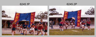
Photograph - Army Survey Regiment’s Fortuna Lions Football Club Grand Finals, Seymour, Victoria, 1983
This is a set of 25 colour photographs of Army Survey Regiment’s Australian Rules football team – the Fortuna Lions aka “Fortuna Fumblers”, taken at Seymour Victoria in 1983. The 26th item is a A4 paper document detailing the history of Fortuna Football Club from 1978 to 1993. The Fortuna Lions competed in the Puckapunyal Area Football Association for several years from 1978 to 1984 and in 1983, fielded a great team it managed to reach the Grand Final. Held at the neutral ground at Kings Park, Seymour, the match was an incredibly exciting and bruising contest played in damp conditions and ended in a draw. Dave Lawler’s spectacular mark was a highlight. Due to heavy rain during the following week, the Grand Final replay was held the following week in even heavier conditions. The Fortuna Lions prevailed in the replay with an emphatic victory. The team’s leaders were Eddie Jacobs (coach), Rhys De Laine (captain), Greg Else (vice-captain), and Ken Slater (manager). See items 6244.27P and 6274.7P for more photographs taken at the two grand finals. Although not part of the photo collection, the team photo with names .24P and a photo of the premiership banner .25P are included. The team changed its name to the Fortuna Falcons and its guernsey to gold with a blue ‘V’ in 1988 and continued to compete in the competition up to 1995.This is a set of 25 photographs of Army Survey Regiment’s Australian Rules football team – the Fortuna Lions aka “Fortuna Fumblers”, taken at Seymour Victoria in 1983. The 26th item is a A4 paper document detailing the history of Fortuna Football Club from 1978 to 1993. The photographs were printed on photographic paper They are part of the Army Survey Regiment’s Collection. The photographs were scanned at 300 dpi and the document at 200 dpi. Fortuna’s footballers named below are in Fitzroy jumpers. .1) - Photo, colour. 1983. L to R: Nick Van Dalen, Jim Ash, Dennis Learmonth, Greg Higgins, Dave Lawler. .2) - Photo, colour. 1983. L to R: Terry McIntyre, Andy Godden, Rod Skidmore, Alan Staley, Carmel Butler, Gayle Humphrey. .3) - Photo, colour. 1983. L to R: Greg Else, Doug Home, Wendy Leitinger, Leah Hoffman, Carmel Butler, Ken Talbot-Smith. .4) - Photo, colour. 1983. L to R: Leah Hoffman, Carmel Butler, Kristin Skidmore, Neville Carr, Brian Fauth on right of banner. .5) - Photo, colour. 1983. L to R: Dave Lawler, Larry Thompson, Rod Skidmore, Greg Higgins, Gayle Humphrey. .6) and .7) - Photo, colour. 1983. Army Survey Regiment, 1st Armoured Regiment and officials line up before game. .8) - Photo, colour. 1983. L to R: unidentified (x2), Kristin Skidmore, Carmel Fauth, Leah Hoffman, Wendy Leitinger, Gayle Humphrey, Di Weston, unidentified, Rob Straube. .9) and .10) - Photo, colour. 1983. Competition’s individual award recipients. Eddie Jacobs in white shorts. .11) and .12) - Photo, colour. 1983. Fortuna’s supporters on boundary. .13) to .15) - Photo, colour. 1983. All players unidentified. .16) - Photo, colour. 1983. Dave Lawler launches to take a spectacular mark. .17) - Photo, colour. 1983. L to R: Stu Ridge (No.2) Eddie Jacobs (No.16), and (No.9). .18) - Photo, colour. 1983. L to R: unidentified (No.9), unidentified, Alan Staley (No.7). .19) - Photo, colour. 1983. L to R: Alan Staley (No.7), unidentified (No.17), unidentified, unidentified (No.9), Greg Higgins (No.20). .20) - Photo, colour. 1983. All players unidentified. .21) - Photo, colour. 1983. Peter Jones (No.5) .22) - Photo, colour. 1983. L to R: Greg Higgins (No.20), unidentified, Alan Staley (No.7). .23) - Photo, colour. 1983. L to R: Unidentified, Greg Byers (No.19). .24) - Photo, colour. 1983. Fortuna Football Club Team Photo. .25) - Banner, colour. 1983. Fortuna Football Club Premiership Banner. .26) - Document, black & white. 1993. History of Fortuna Football Club from 1978 to 1993..1P to .23P – no annotations .24P – Members of team named on bottom .26 - A4 size paper document of the team’s history.royal australian survey corps, rasvy, army survey regiment, army svy regt, fortuna, asr -
 Bendigo Military Museum
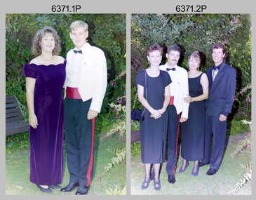
Photograph - Army Survey Regiment Summer Ball – Officers and Guests Arrival, 1995
This is a set of 33 photographs taken at the combined Officer, Warrant Officer and Sergeant’s Mess Summer Ball held at the Army Survey Regiment (ASR), Fortuna Villa on the 25th of February, 1995. The Summer Ball was one of the last large scale formal functions held at Fortuna Villa before ASR’s closure the following year. Photos of personnel and their guests was taken on their arrival near the Pompeii Fountain in the gardens at the front of the main building. The Ball and Dinner was held at the rear of Fortuna Villa in temporary 20’ x 30’ Army tents set up on the roadway in front of the transport compound. SERCO contract staff provided the catering and the ASR’s Other Ranks performed stewarding and kitchen hand duties. Refer to item 6347 for information on the administrative file held in the collection and items 6370.23P, 6372.25P and 6373.36P for additional photographs taken at the Summer Ball.This is a set of 33 photographs taken at the Officer, Warrant Officer and Sergeant’s Summer Ball held at the Army Survey Regiment, Fortuna Villa on the 25th of February, 1995. The colour photographs are on 35mm negative film and are part of the Army Survey Regiment’s Collection. The photographs were scanned at 96 dpi. .1) - Photo, colour, 1995. Darren Radford and partner. .2) - Photo, colour, 1995. L to R: Craig Hersant and partner, Mrs & Mr Foster. .3) - Photo, colour, 1995. Stan and Maureen Vote. .4) - Photo, colour, 1995. Gordon (Muddle) Muir and partner. .5) - Photo, colour, 1995. John South and partner. .6) - Photo, colour, 1995. Bill and Jan Griggs. .7) - Photo, colour, 1995. John Bath and partner. .8) - Photo, colour, 1995. John Bath and Tara Bucknall. .9) - Photo, colour, 1995. Roger Grose and partner. .10) - Photo, colour, 1995. L to R: John Bath and partner, Roger Grose and partner. .11) - Photo, colour, 1995. Peter Crabbe and Jodi Cuskelly. .12) - Photo, colour, 1995. Marianne and Colin Cuskelly. .13) - Photo, colour, 1995. L to R: Peter Crabbe and Jodi Cuskelly, Marianne and Colin Cuskelly. .14) - Photo, colour, 1995. L to R: Maria and Tony Harder with daughter. .15) - Photo, colour, 1995. Brenton and Marg McDonald. .16) - Photo, colour, 1995, L to R: unidentified guests, Brenton McDonald and partner. .17) - Photo, colour, 1995. Frank Franceschini and partner. .18) - Photo, colour, 1995. Mick and Cathy Banham. .19) - Photo, colour, 1995. Ross Jenkins and partner. .20) - Photo, colour, 1995. L to R: Vik and Julia Sabaliauskas, Ross Jenkins and partner. .21) - Photo, colour, 1995. L to R: Noel and Jenny Coulthard. .22) - Photo, colour, 1995. A. Carrol-Keys (RACT) and partner. .23) - Photo, colour, 1995. Peter Cates and partner. .24) - Photo, colour, 1995. Terry and Sharon Lord. .25) - Photo, colour, 1995. Dave and Sue Stephenson. .26) - Photo, colour, 1995. Unidentified member and partner. .27) - Photo, colour, 1995. Simon Lemon and partner. .28) - Photo, colour, 1995. Glen Swiney and Don Swiney MBE. .29) & .30) - Photo, colour, 1995. Sandra and Duncan Burns. .31) - Photo, colour, 1995. L to R: Duncan and Sandra Burns, unidentified member and partner. .32) - Photo, colour, 1995. L to R: Unidentified member and partner, Matt Jackson and partner. .33) - Photo, colour, 1995. L to R: Glen Swiney, Simon Lemon, Dave Stephenson and partner, Simon Lemon’s partner, Andy Cordova (USA Exchange), Don Swiney MBE.1P to .33P There are no personnel or civilians identified.royal australian survey corps, rasvy, army survey regiment, army svy regt, fortuna, asr -
 Stawell Historical Society Inc
Map, Department of Crown Lands and Survey Victoria, Allotments in the Township of Banyana. Parish of Burrum Burrum. 1946 / 1971, 1971
Richardson River. Avon River JunctionPaper Map of County of BorungReprint of the 1946 edition. Drawn and reproduced at the Department of Crown Lands and Survey Victoria 1971.survey -
 Bendigo Military Museum
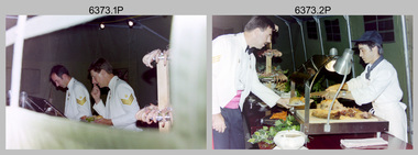
Photograph - Army Survey Regiment Summer Ball - Dinner, Staff and Entertainment, 1995
This is a set of 36 photographs taken at the combined Officer, Warrant Officer and Sergeant’s Mess Summer Ball held at the Army Survey Regiment (ASR), Fortuna Villa on the 25th of February 1995. The Summer Ball was one of the last large scale formal functions held at Fortuna Villa before ASR’s closure the following year. Photos of personnel and their guests was taken on their arrival near the Pompeii Fountain in the gardens at the front of the main building. The Ball and Dinner was held at the rear of Fortuna Villa in temporary 20’ x 30’ Army tents set up on the roadway in front of the transport compound. SERCO contract staff provided the catering and the ASR’s Other Ranks performed stewarding and kitchen hand duties. Refer to item 6347 for information on the administrative file held in the collection and items 6370.23P, 6371.33P and 6372.25P for additional photographs taken at the Summer Ball.This is a set of 36 photographs taken at the Officer, Warrant Officer and Sergeant’s Summer Ball held at the Army Survey Regiment, Fortuna Villa on the 25th of February 1995. The colour photographs are on 35mm negative film and are part of the Army Survey Regiment’s Collection. The photographs were scanned at 96 dpi. .1) - Photo, colour, 1995. L to R: Rod Skidmore, Bob Thrower. .2) - Photo, colour, 1995. L to R: Jim Ash, unidentified SERCO-GM staff. .3) - Photo, colour, 1995. L to R: Helen Drummond, Stan Vote, Steve Drummond. .4) - Photo, colour, 1995. L to R: Helen Drummond, Steve Drummond, unidentified, Stan Vote, .5) - Photo, colour, 1995. Sherri and Steve Burke .6) - Photo, colour, 1995. L to R: Dale Hudson and partner. .7) - Photo, colour, 1995. L to R: Alan Dudley, Glenda Stear, Doug Carswell, unidentified, Chris Carswell, John Stear, Angela Dudley, Tony Harder (background). .8) - Photo, colour, 1995. L to R: John Phillips, Maria Harder. .9) - Photo, colour, 1995. L to R: Tracey Phillips, Peter Peterson. .10) - Photo, colour, 1995. L to R: John South, Tracey Phillips, Peter Peterson, John Bath (background), Miss Delfine. .11) - Photo, colour, 1995. Jo and Peter Peterson. .12) - Photo, colour, 1995. Colin Davidson, Jason Selman, Martin Evans (background). .13) - Photo, colour, 1995. L to R: Bill Griggs (background), Colin Cuskelly. .14) - Photo, colour, 1995. Marzipan sculpture of Australia’s Coat of Arms animals surround RA Svy Corps badge. ‘53’ denoted the number of years of RA Svy occupancy since 1942. .15) - Photo, colour, 1995. L to R: unidentified (x3), Sandra Burns, Brianna Burgin (steward in background). .16) - Photo, colour, 1995. L to R: Mrs Willis, Dave and Sue Stephenson, Corey Hill (steward in background), unidentified, Ros and Wolfgang Effenberg, Doug Willis, unidentified, Simon Lemon (background). .17) - Photo, colour, 1995. unidentified SERCO-GM staff. .18) - Photo, colour, 1995. L to R: Hayden Beer, Duncan Burns (background), Simon Lemon, unidentified SERCO staff (x2). .19) & .20) - Photo, colour, 1995. L to R: Duncan Burns, unidentified SERCO-GM staff. .21) - Photo, colour, 1995. L to R: Mrs Willis, Greg Byers. .22) - Photo, colour, 1995. L to R: Brian Sloan, unidentified. .23) - Photo, colour, 1995. Justine (Sachs) Rainey - steward. .24) - Photo, colour, 1995. Marty Stradbrook- steward. .25) - Photo, colour, 1995. Unidentified guests, Corey Hill - steward. .26) - Photo, colour, 1995. L to R: Troy Larkins, Ken Labouchardiere, Marty Stradbrook, Lance Hillier, unidentified. .27) - Photo, colour, 1995. L to R: Glen Norrell, Trevor King, Troy Larkins. .28) to .31) - Photo, colour. 1995. Unidentified string quartet musicians. .32) to .36P) - Photo, colour. 1995, Fortuna Pipes and Drums musicians..1P to .36P There are no personnel or civilians identified.royal australian survey corps, rasvy, army survey regiment, army svy regt, fortuna, asr -
 Bendigo Military Museum
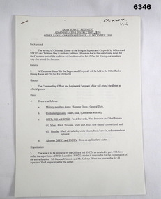
Administrative record - Army Survey Regiment - Admin Instr 35/94 OR's Christmas Dinner 1994, Army Survey Regiment, Bendigo, 7 Nov 1994
The serving to the living - in Sappers and Corporals by the Officers and SNCOs on Christmas Day is an Army tradition. As the Army Survey Regiment would be closed down during the Christmas period this tradition was observed on Friday 02 Dec 1994. Living - out ORs and CPLs could attend. This Admin Instruction describes the duties and arrangements for that occasion.Six A4 paper pages stapled in the top left hand corner"CPL Knott" top right cornerroyal australian survey corps, rasvy, fortuna, army survey regiment, army svy regt, asr -
 Bendigo Military Museum
Photograph - 4th Field Survey Squadron – Operation NERVOSE Driver Training and Pre-Pack, Keswick Barracks, Adelaide SA, 1985
This is a set of 28 photographs taken in 1985* during 4th Field Survey Squadron’s driver training preparation and packing at Keswick Barracks, Adelaide SA, in preparation for Operation NERVOSE. Operation NERVOSE 85 was mounted by 4 Fd Svy Sqn in the EAST ARNHEM, VICTORIA RIVER DOWNS AND DALY WATERS areas of the Northern Territory from 26 May to 18 Sep 85. The aim of Operation NERVOSE 85 was to finalise the horizontal and vertical control for mapping at a scale of 1:50,000, to field check 40x 1:50,000 preliminary maps and to obtain mapping photography in support of the RAAF TINDAL redevelopment project. *Note –These photos were most likely taken in 1985, contrary to the ‘1987’ date annotated on the negative sleeves. The Op NERVOSE 85 Project Report available on RASVY’s web site lists a nominal roll of personnel. Photos of 4 Fd Svy Sqn taken in 1985 and 1987 provide names of posted personnel. Several personnel identified in these photos were posted to 4 Fd Svy Sqn in 1985, not in 1987. See items 6504.13P, 6506.16P and 6507.20P for more photos taken prior to and during Operation NERVOSE 85. This is a set of 28 photographs taken in 1985 during 4th Field Survey Squadron’s driver training preparation and packing at Keswick Barracks, Adelaide SA, in preparation for Operation NERVOSE. The colour photographs are on 35mm negative film and are part of the Army Survey Regiment’s Collection. The photographs were scanned at 96 dpi. .1) to .9) - Photo, colour, 1985. Driver training. Unidentified personnel. .10) - Photo, colour, 1985. Driver training. Bent trailer hitch shaft. .11) - Photo, colour, 1985. Theodolite set-up. L to R: CPL Kevin Whitty, CPL Alan ‘Hawkeye’ Hawkins. .12) to .14) - Photo, colour, 1985. Theodolite practice. L to R: CPL Alan ‘Hawkeye’ Hawkins, CPL Kevin Whitty. .15) - Photo, colour, 1985. Pre-packing and preparation. .16) - Photo, colour, 1985. Pre-packing and preparation. L to R: SGT Roger Rees, CPL P. Kennedy, unidentified. .17) - Photo, colour, 1985. Pre-packing and preparation. L to R: unidentified (x6), CPL Pat Drury. .18) - Photo, colour, 1985. Pre-packing and preparation. CPL Bill Choy. .19) - Photo, colour, 1985. Pre-packing and preparation. Unidentified personnel. .20) - Photo, colour, 1985. Pre-packing and preparation. L to R: LCPL Chris ‘Charlie’ Brown, WO2 Stevo Hinic, CPL Andy Lucas, SSGT George Timmins, unidentified (x3). .21) - Photo, colour, 1985. Pre-packing and preparation. L to R: MAJ Peter Bion – OC, unidentified officer, CPL Andy Lucas, SSGT George Timmins, WO2 Stevo Hinic, unidentified. .22) - Photo, colour, 1985. Pre-packing and preparation. L to R: MAJ Peter Bion – OC, unidentified officer, unidentified, SSGT George Timmins, WO2 Stevo Hinic, unidentified. .23) - Photo, colour, 1985. Pre-packing and preparation. L to R: unidentified, CPL Andy Lucas, MAJ Peter Bion – OC, unidentified officer, SSGT George Timmins, WO2 Stevo Hinic. .24) - Photo, colour, 1985. Pre-packing and preparation. L to R: SSGT George Timmins, CPL Bill Choy. .23) - Photo, colour, 1985. Pre-packing and preparation. L to R: Stevo Hinic, CPL Andy Lucas. .26) - Photo, colour, 1985. Pre-packing and preparation. L to R: CPL Kevin Whitty, SPR Dave Lambdon-Young. .27) & .28) - Photo, colour, 1985. Pre-packing and preparation. L to R: CPL Andy Lucas, Stevo Hinic..1P to .28P – There are no personnel identified. ‘1987 OP NERVOSE PRE-PACK.’ annotated on negative sleeve.royal australian survey corps, rasvy, 4 fd svy sqn, op nervose 85 -
 Bendigo Military Museum
Document - Australian School of Military Survey - Stereotemplets Precis, School of Military Survey, Balcombe, Unknown
A 6 x page foolscap sized precis, two hole punched and stapled produced by the Australian School of Military Survey discusses using Stereo templet triangulation of aerial photography to establish extra supplementary horizontal control positions. Triangulation using Stereo Templates is a method of achieving the horizontal scale solutions required for photogrammetric mapping procedures.A 6 x page foolscap sized precis, two hole punched and stapled. The precis does not have a protective coverNo "61" on the top LH Cornerroyal australian survey corps, rasvy, fortuna, army survey regiment, army svy regt, asr, sms -
 Bendigo Military Museum
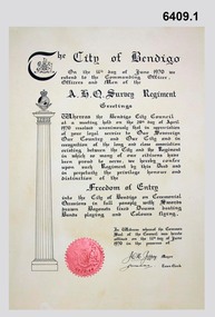
Certificate - Army Survey Regiment City of Bendigo Freedom of Entry Certificate 1970, Ian Wallace and AHQ Survey Regiment, Bendigo, June 1970
The certificate was issued by the City of Bendigo to AHQ Survey Regiment awarding the Regiment "Freedom of Entry" on ceremonial occasions. The certificate recognises the long service and close association between the Regiment and the City. Three certificates with seals were produced. One held by the City of Bendigo, one held by the Regiment and one was held by Ian Wallace who produced the certificates when he was part of the City's Engineering Department. The Freedom of Entry to the City was first conferred by the Bendigo City Council to the Army Survey Regiment in 1970. The unit then exercised its freedom by marching into the city with swords drawn, bayonets fixed and drums beating. The honour is usually bestowed upon local regiments, in recognition of their dedicated service, and it is common for military units to periodically exercise their freedom by arranging a parade through the city. The parade generally concluded after formal inspections of the troops. Regiment members were often treated to a civic reception at the City Hall after the ceremony. The Regiment also exercised its Freedom of Entry with anniversary parades in 1977, 1980, 1985, 1990 and 1995.The Regiment copy of the certificate was sent to the Army Military Museum at Holsworthy when the unit was disbanded and this copy (6409.1) held in the Bendigo RSL Museum is the copy that was originally held by the City of Bendigo. 6409.2 is a photograph of Gary Warnest, President ExFortuna Survey Association (left) holding the certificate 6409.1 and Mr Ian Wallace the certificate producer (right).Large framed certificate. Wooden frame, glass protecting the certificate.royal australian survey corps, rasvy, fortuna, army survey regiment, army svy regt, asr -
 Bendigo Military Museum
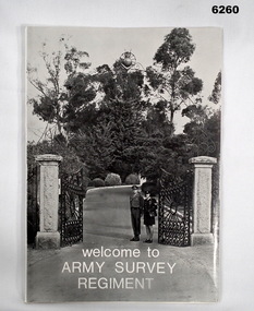
Booklet - Welcome to the Army Survey Regiment, Army Survey Regiment, Circa late 1970's
An information booklet provided to new arrivals at the Army Svy Regt. It contains information on daily routine, unit facilities and services, accommodation options, sports policy, Regimental Appointments, recreational facilities and places of interest around Bendigo. Cover photo of the gate entrance to the Army Survey Regiment on the cover. WO1 Ken and Cpl Heather Slater stand at the gate. A4 soft covered booklet, paper pages held together with "ARNOS" an Fastenerroyal australian survey corps, rasvy, fortuna, army survey regiment, army svy regt, asr -
 Bendigo Military Museum
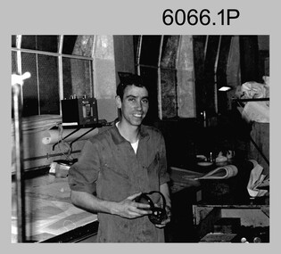
Photograph - Printer Technicians Operating Printing Presses at the Army Survey Regiment, c1980s
These nine photographs of Printer Technicians operating printing presses were probably taken circa 1980s in Lithographic Squadron at the Army Survey Regiment, Fortuna, Bendigo. c1980s. They are most likely operating the Komori, Planeta or Ultra-MAN-III offset printing presses. Although most photos except for photos .1P to .4P are not annotated, most personnel are positively identified..1) - Photo, black & white, c1980s, SPR Mark ‘Dogs’ Doherty, Lithographic Squadron .2) - Photo, black & white, c1980s, Paul Davis, Lithographic Squadron .3) - Photo, black & white, c1980s, L to R: unidentified, CPL Peter Breukel, Lithographic Squadron .4) - Photo, black & white, c1980s, SPR Colin Campbell, Lithographic Squadron .5) - Photo, black & white, c1980s, CPL Paul Davis, Lithographic Squadron .6) - Photo, black & white, c1980s, CPL Paul Davis, Lithographic SPR Mark ‘Dogs’ Doherty Squadron .7) - Photo, black & white, c1980s, L to R: WO2 Jeff Lynch, CPL Paul Davis, Lithographic Squadron .8) - Photo, black & white, c1980s, unidentified, Lithographic Squadron .9) - Photo, black & white, c1980s, CPL Josh De Groot, Lithographic Squadron .1P to .4P – personnel annotated .5P to .6P, .8P to .9P – no annotation .7P – no personnel annotated, ‘Last PNG JOG’ annotatedroyal australian survey corps, rasvy, army survey regiment, army svy regt, fortuna, asr, litho, printing -
 Bendigo Military Museum
Photograph - Military Funeral for SSGT Peter Dew, Army Survey Regiment, Fortuna, Bendigo, 1977
This is a set of 29 black & white photographs of troops from the Army Headquarters Survey Regiment undertaking ceremonial drill at the military funeral for SSGT Peter Dew on the 28th of September 1977. The location of the funeral service was at Fortuna, Bendigo. He was buried at Bendigo Cemetery in Quarry Hill. Peter Dew died in a tragic accident at home. He was fondly remembered as one of Lithographic Squadron’s colourful personalities. See item 6243.7P for photos of Peter Dew at work in Lithographic Squadron. The "Super Animal of the Year" Peter Dew Memorial Award was an award presented to a member of the squadron for a crude act. To view a photo of this award, refer to item 6230 of the Victorian Collections. Some photos in this set were also printed on photo paper and catalogued under item 6335.5P.This is a set of 29 black & white photographs of troops from the Army Headquarters Survey Regiment undertaking ceremonial drill at the military funeral for SSGT Peter held in 1977. The photographs are on 35mm negative film and scanned at 96 dpi. They are part of the Army Survey Regiment’s Collection. .1) - Photo, black & white, 1977. Rifle party commander: CPL Greg Kidman. Right file right marker: SPR Russ Mollenhauer, unidentified soldiers and civilians. .2) - Photo, black & white, 1977. Unidentified soldiers and civilians. .3) - Photo, black & white, 1977. R to L: SSGT Alan Adsett, WO2 John McCulloch, SGT Graeme Jeffers in foreground holding hats. Remainder unidentified. .4) to .6) - Photo, black & white, 1977. Unidentified soldiers and civilians. R to L: SSGT Alan Adsett, WO2 John McCulloch, unidentified soldiers and civilians. .7) - Photo, black & white, 1977. Pall bearers position the coffin onto the gun carriage. Rifle party commander: CPL Greg Kidman. Right file right marker: SPR Russ Mollenhauer. Seen in background to the right of pall bearers: L to R: CPL Ian Belmont, unidentified, facing away- PTE Le-anne (Smallshaw) Shirley, CPL Di Chalmers, unidentified soldiers and civilians. .8) - Photo, black & white, 1977. Rifle party rear rank right marker: Russ Mollenhauer. Front rank rifle party commander next to right marker: Greg Kidman. Pall bearers in front of vehicle L to R: Dave Miles, Dick Barwald. Remainder unidentified. .9) - Photo, black & white, 1977. In position at beginning of funeral procession, unidentified soldiers and civilians. .10) & .11) - Photo, black & white, 1977. Rifle party commander: CPL Greg Kidman and the rifle party slow march past the front of Fortuna Villa. .12) - Photo, black & white, 1977. The rifle party slow march past the front of Fortuna Villa. Rifle party commander: Greg Kidman. Right file front to back: SPR Russ Mollenhauer, SPR Peter Breukel, SPR Bill Jones, SPR John Anderson. Remainder unidentified. Left file front to back: SPR Jeff Willey, unidentified, SPR Rhys De Laine, SPR Frank Lenane, SPR Josh Degroot, SPR Gary Drummond. .13) - Photo, black & white, 1977. The rifle party slow march past the front of Fortuna Villa. Rifle party commander: Greg Kidman. Right file: SPR Russ Mollenhauer, Left file: SPR Jeff Willey, remainder unidentified. .14) - Photo, black & white, 1977. The rifle party march at quick time towards the entry gate. .15) - Photo, black & white, 1977. The rifle party march at quick time past the front of Fortuna Villa. Rifle party commander: Greg Kidman. Right file: SPR Russ Mollenhauer, Left file: SPR Jeff Willey, remainder unidentified. .16) - Photo, black & white, 1977. The procession marches at quick time towards the entry gate. .17) - Photo, black & white, 1977. The procession departs the entry gate. .18) to .21)- Photo, black & white, 1977. The procession passes through the cemetery. .22) - Photo, black & white, 1977. The procession passes through the cemetery. RSM Wo1 Aub Harvey at far left. Remainder unidentified. .23) - Photo, black & white, 1977. Pallbearers carry Peter Dew’s coffin to the grave site. .24) - Photo, black & white, 1977. The rifle party in position at ‘rest on arms reverse’. .25) - Photo, black & white, 1977. Service at grave site. Left of minister: SGT Alan Toogood. On right of tree L to R: WO2 Max Neil, WO2 Bob Hayden, WO1 Dave Malligan, PTE Le-Anne (Smallshaw) Shirley, CAPT Stan Vote. Remainder unidentified. .26) - Photo, black & white, 1977. The rifle party fire volleys. .27) - Photo, black & white, 1977. The rifle party presents arms. .28) - Photo, black & white, 1977. Service at grave site. SGT Greg Francis-Wright 4th from right. .29) - Photo, black & white, 1977. Outside Litho’s proofing hut at Fortuna. WO1 Darby Munro stands in contemplation next to the collection of flowers.There are no personnel identified. royal australian survey corps, rasvy, army survey regiment, army svy regt, fortuna, asr, litho sqn -
 Bendigo Military Museum
Photograph - Army Survey Regiment –Defence Force Service Medal Presentations, Fortuna Villa, Bendigo, 1976
This is a set of 29 photographs of the presentation of the Defence Force Service Medal to personnel in recognition of 15 years of efficient remunerated service, or the Clasp for 5 years of additional service, at the Army Survey Regiment, Bendigo on Corps Day, 1st of July 1976. In photos .1P to .20P, MAJGEN John Williamson AO, OBE GOC FF COMD is featured presenting the Defence Force Service Medal On a separate occasion in photos .19P to .23P, BRIG Brigadier Jim Shelton DSO, MC, MID COMD is featured presenting the Defence Force Service Medal. Photos .6P and.19P to .23P are also catalogued in item 6037.9P.This is a set of 29 photographs of the presentation of the Defence Force Service Medal, at the Army Survey Regiment, Bendigo on Corps Day, 1st of July 1976. The black & white photographs are on 35mm negative film and are part of the Army Survey Regiment’s Collection. The photographs were scanned at 96 dpi. .1) to 2) - Photo, black & white, 1976. L to R: SSGT Gordon Haswell, Defence Force Service Medal presented to CO LTCOL Bob Skitch by MAJGEN John Williamson AO, OBE. .3) - Photo, black & white, 1976. L to R: RSM WO1 Aub Harvey, SSGT Gordon Haswell marches off after the presentation of the Defence Force Service Medal by MAJGEN John Williamson AO, OBE. .4) - Photo, black & white, 1976. L to R: SSGT Gordon Haswell, Defence Force Service Medal presented to MAJ Noel Sproles by MAJGEN John Williamson AO, OBE. On right: RSM WO1 Aub Harvey, ADJT CAPT Dennis Puniard. .5) - Photo, black & white, 1976. L to R: SSGT Gordon Haswell, Defence Force Service Medal presented to WO1 Tony Ellis by MAJGEN John Williamson AO, OBE. On right: RSM WO1 Aub Harvey, ADJT CAPT Dennis Puniard. .6) - Photo, black & white, 1976. L to R: SSGT Gordon Haswell, Defence Force Service Medal presented to WO1 Marj Knight by MAJGEN John Williamson AO, OBE, On right: RSM WO1 Aub Harvey. .7) - Photo, black & white, 1976. L to R: SSGT Gordon Haswell, Defence Force Service Medal presented to WO1 Fred Panknin by MAJGEN John Williamson AO, OBE, On right: RSM WO1 Aub Harvey. .8) - Photo, black & white, 1976. L to R: SSGT Gordon Haswell, Defence Force Service Medal presented to WO2 Alan Bunn by MAJGEN John Williamson AO, OBE. On right: RSM WO1 Aub Harvey, ADJT CAPT Dennis Puniard. .9) - Photo, black & white, 1976. L to R: CO LTCOL Bob Skitch, SSGT Gordon Haswell, Defence Force Service Medal presented to WO2 Max Neil by MAJGEN John Williamson AO, OBE. .10) - Photo, black & white, 1976. L to R: CO LTCOL Bob Skitch, SSGT Gordon Haswell, Defence Force Service Medal presented to WO2 Tibby Szentirmay by MAJGEN John Williamson AO, OBE. On right: RSM WO1 Aub Harvey. .11) - Photo, black & white, 1976. L to R: WO1 Tony Ellis, MAJ Noel Sproles, CO LTCOL Bob Skitch, SSGT Gordon Haswell, RSM WO1 Aub Harvey, ADJT CAPT Dennis Puniard, MAJGEN John Williamson AO, OBE. .12) - Photo, black & white, 1976. L to R: WO2 Tibby Szentirmay, WO2 Max Neil, WO2 Alan Bunn, WO1 Fred Panknin, WO1 Marj Knight, WO1 Tony Ellis, MAJ Noel Sproles, CO LTCOL Bob Skitch, SSGT Gordon Haswell, ADJT CAPT Dennis Puniard, RSM WO1 Aub Harvey. .13) - Photo, black & white, 1976. L to R: WO2 Tibby Szentirmay, WO2 Max Neil, WO2 Alan Bunn, WO1 Fred Panknin, WO1 Marj Knight, WO1 Tony Ellis, MAJ Noel Sproles, CO LTCOL Bob Skitch, MAJGEN John Williamson AO, OBE, SSGT Gordon Haswell, RSM WO1 Aub Harvey, ADJT CAPT Dennis Puniard. .14) - Photo, black & white, 1976. L to R: WO2 Tibby Szentirmay, WO2 Max Neil, WO2 Alan Bunn, WO1 Fred Panknin, WO1 Marj Knight, WO1 Tony Ellis, MAJ Noel Sproles, CO LTCOL Bob Skitch, SSGT Gordon Haswell, MAJGEN John Williamson AO, OBE, RSM WO1 Aub Harvey, ADJT CAPT Dennis Puniard. .15) & .16) - Photo, black & white, 1976. L to R: WO2 Tibby Szentirmay, WO2 Max Neil, WO2 Alan Bunn, WO1 Fred Panknin, WO1 Marj Knight, WO1 Tony Ellis, MAJ Noel Sproles, CO LTCOL Bob Skitch, SSGT Gordon Haswell, CAPT Dennis Puniard. .17) - Photo, black & white, 1976. L to R: WO2 Tibby Szentirmay, WO2 Max Neil, WO2 Alan Bunn, WO1 Fred Panknin, WO1 Marj Knight, WO1 Tony Ellis, MAJ Noel Sproles, CO LTCOL Bob Skitch, SSGT Gordon Haswell. .18) - Photo, black & white, 1976. L to R: WO2 Tibby Szentirmay, WO2 Max Neil, WO2 Alan Bunn, WO1 Fred Panknin, WO1 Marj Knight, WO1 Tony Ellis, MAJ Noel Sproles, CO LTCOL Bob Skitch, SSGT Gordon Haswell, RSM WO1 Aub Harvey, MAJGEN John Williamson AO, OBE, ADJT CAPT Dennis Puniard. .19) & .20) - Photo, black & white, c1976. Defence Force Service Medal presented to WO1 Don Taylor by BRIG Jim Shelton DSO, MC, MID. On right: ADJT CAPT Dennis Puniard. .21) to .23) - Photo, black & white, c1976. Defence Force Service Medal presented to SGT Syd Davis by Brigadier Jim Shelton DSO, MC, MID. .24) - Photo, black & white, 1976. Post Defence Force Service Medal presentations. CAPT Gary Kenney in centre of photo. .25) - Photo, black & white, 1976. Post Defence Force Service Medal presentations. L to R: WO1 Tony Ellis in foreground, identified with guests in background LT Rob John, SSGT Dave Miles, WO1 Doug Malligan, WO1 Bill Boyd, WO2 Max Neil, WO1 Darby Munro, MAJ Peter Eddy, WO1 Marj Knight. .26) - Photo, black & white, 1976. Post Defence Force Service Medal presentations. L to R: WO1 Sam Chambers, MAJGEN John Williamson AO, OBE with guests. .27) - Photo, black & white, 1976. Post Defence Force Service Medal presentations. Bendigo. L to R: WO1 Sam Chambers, Legislative Council Member for Bendigo Mr. Bruce Reid meets MAJGEN John Williamson AO, OBE with guests. CO LTCOL Bob Skitch in background. .28) - Photo, black & white, 1976. Post Defence Force Service Medal presentations. Bendigo. L to R: unidentified, WO1 Sam Chambers, unidentified (x3), Min Chambers (switchboard operater), unidentified, LT Rene van den Tol, CO LTCOL Bob Skitch, MAJGEN John Williamson AO, OBE with guests. .29) - Photo, black & white, 1976. Post Defence Force Service Medal presentations. Bendigo. L to R: LT Rene van den Tol, CO LTCOL Bob Skitch, MAJGEN John Williamson AO, OBE with guests..1P to .29P – No personnel are identified. Date and occasion annotated on film negative sleeve.royal australian survey corps, rasvy, army survey regiment, army svy regt, fortuna, asr -
 Bendigo Military Museum
Photograph - Royal Australian Survey Corps Surveyors in the Field, Army Survey Regiment, 1950s to 1970s
These three photographs were most likely taken from the 1950s to the 1970s. The RASvy surveyor in each photograph was taking angular measurements with the observer recording their readings on a booking form. They were probably employed in establishing mapping and geodetic control operations or the surveyors may have been in training. Photo .1P was possibly taken at Mount Alexander in Central Victoria, a location close to Bendigo, as the stone cairn in the background of the photo appears to be identical to the cairn presently located on top of the mountain. Personnel and location have been confirmed on another photo in the collection with annotation. These three photographs are of surveyors in the field undertaking observations using theodolites. The photographs were printed on photographic paper and are part of the Army Survey Regiment’s Collection. The photographs were scanned at 300 dpi. .1) - Photo, black & white, c1950s. Unidentified personnel undertaking observations with a Tavistock geodetic theodolite. .2) – Photo, colour, mounted on card, c1960s. Unidentified personnel undertaking observations with a Kern DKM2 theodolite. .3) - Photo, colour, c1970s. Unidentified personnel undertaking observations with a theodolite..1 – not annotated .2 –annotated on front “Kern DKM2, TOPO 10” royal australian survey corps, rasvy, army survey regiment, army svy regt, fortuna, asr, surveying -
 Bendigo Military Museum
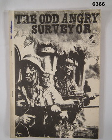
Administrative record - Army Survey Regiment Regimental Training 1984 - The Odd Angry Surveyor, Army Survey Regiment, Bendigo, 21 Feb 1984
This is an Administrative Instruction setting out all aspects of the Army Survey Regiment Regimental Training Exercise "Odd Angry Surveyor" during the period 30 Apr - 12 May 1984. The Exercise conducted in two phases, Phase One- being theory lessons in a number of aspects of Infantry Minor Tactics at Section Level, whilst Phase Two- was putting into practice the lessons from Phase One.Light carboard covered A4 paper report stapled on left hand sideroyal australian survey corps, rasvy, fortuna, army survey regiment, army svy regt, asr