Showing 2471 items matching " township"
-
 Kiewa Valley Historical Society
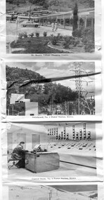
Postcard - Mt Beauty and the Kiewa Hydro Electric Scheme
SECV constructed the Kiewa Hydro Electric Scheme including the township of Mt Beauty. The area became a popular tourist destination.Tourism in the Kiewa Valley especially at Mt Beauty and the Bogong High Plains along with the Kiewa Hydro Electric Scheme became very popular and an important industry.Fold out b & w postcard with 12 photos back to back. All with a title. Kate 1950s 1. High Voltage Transmission Line, showing Mount Beauty Township 2. Clover Dam Reservoir, Kiewa 3. No. 3 Power Station, Kiewa 4. Generators, No. 3 Power Station 5. Turbines, No. 4 Power Station, Kiewa 6. junction Dam, Bogong 7. Mt Beauty Village Shopping Centre 8. Switchyard, No. 4 Power Station, Kiewa 9. Control Room, No. 4 Power Station, Kiewa 10. Winter Scene at Rocky Valley on the Bogong High Plains 11. Water Channel, Mt Bogong in Background 12. Mt Beauty Township, Kiewa Valleytransmission line, power station, generators, mt beauty, turbines, junction dam, switchyard, rocky valley, control room -
 Lakes Entrance Historical Society
Photograph - Thunderbird, Holding M, 2000c
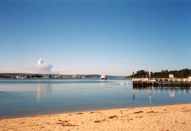
Colour photograph of the township viewed from the southern shore of Cunninghame Arm at the New Works. New Works Jetty in mid foreground, tourist launch Thunderbird on lake. Smoke from a bushfire in distance. Reflections in calm waters of lake. Lakes Entrance Victoria tourism, waterways, township, boats and boating -
 Lakes Entrance Historical Society
Photograph - New Works, Phillips, Miss L, 1900c
Also other black and white copy 9 x 14 cm, donated by Russell Goff with inscription The TownSepia photograph showing view from the dunes across lake, and Cunninghame Arm, to township. Foreground shows dense vegetation on dunes behind two houses, harbour engineer's house on left and contractor John Carpenter's house on right. Lakes Entrance Victoriawaterways, township, boats and boating, topography -
 Port Melbourne Historical & Preservation Society
Map - Footscray, Public Lands Office, 19 Oct 1857
Map of Footscray, west of Saltwater Creek; south of Hopkins Street, east of Railway and north southern boundary of Botanical Garden reserve.The Township of Footscray, Parish of Cut-Paw-Pawfootscray -
 Linton and District Historical Society Inc
Photograph, Photographer: Alan Giles, Aerial View, Sussex Street, Linton, 1991, 1.9.1991
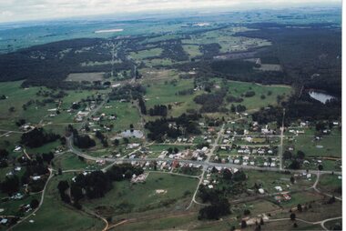
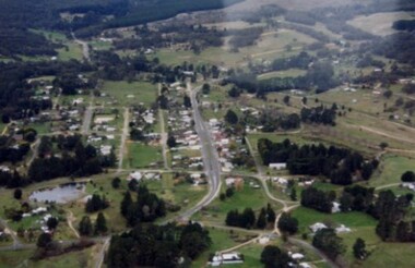
Aerial view of Linton, Sussex St (Glenelg Highway) running from RH bottom corner, Mortchup Road reservoir centre RH side."Linton Township, Vic-1st September 1991".linton township, sussex street linton -
 Linton and District Historical Society Inc
Photograph, Aerial photo of Sussex Street, Linton, 1991, 1991
Photograph taken by Historical Society member Alan Giles, on a joy flight over Linton.Aerial photograph taken 1.9.1991 Linton looking north along Sussex St showing Edinburgh Reserve to Recreation Reserve and Ballarat Road."Linton Township, Vic. 1st Sept 1991".linton township, sussex street linton -
 Lakes Entrance Historical Society
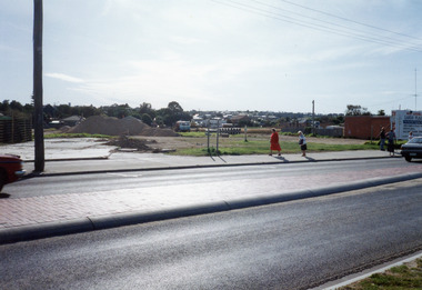
Photograph - Safeway Supermarket, Holding M, 1994
Date made May 1994Colour photograph of the old Carnival site, Esplanade, showing preliminary work on site of Safeway Supermarket. Pile of sand and soil, tip truck and pile of large diameter pipes on site. Five people on footpath beside highway which has tiled traffic island division. Township houses in the background. Lakes Entrance Victoriatownship, transport, retail trade -
 Lakes Entrance Historical Society
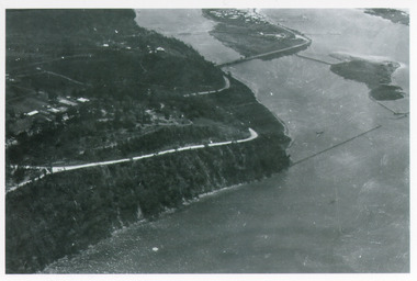
Photograph - Kalimna, Bulmer H D, 1940c
Black and white photograph of aerial view of Kalimna Heights, showing scattered buildings, Princes Highway around side of cliff, western end of township, North Arm bridge, footbridge to Bullock Island, and rock groynes. Track to lookout and signal beacon visible. Lakes Entrance Victoria waterways, roads and streets, bridges, township -
 Lakes Entrance Historical Society
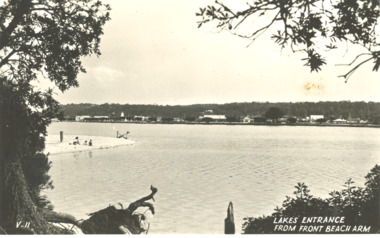
Postcard - Sand hummocks Lakes Entrance Victoria c1940
Black and white postcard taken from sand hummocks looking across Cunninghame Arm to township, sandy beach known as Play Point shown left centre of image Lakes Entrance Victoria c1940. Also two other black and white postcards showing similar viewsLakes Entrance from Front Beach Arm and Lakes Entrancee from the South Side waterways, vegetation, township, houses -
 Pyrenees Shire Council
painting, Heather Featherson, Beaufort from Camp Hill by Heather Featherson, 2007
significant as a work of art by local Pyrenees artist, locally significant to the Central Highlands Region of Victoria as a representation of local landscape and/or culture Landscape painting of Beaufort Townshipsigned: H FEATHERSTON (lower right) -
Clunes Museum
Newspaper - NEWSPAPER CUTTING, BALLARAT COURIER PTY. LTD, Nov-81
CUTTING TAKEN FROM THE SUPPLEMENT TO THE BALLARAT COURIERNEWSPAPER CUTTING OF CLUNES TOWNSHIPlocal history, document, newspaper cutting, clunes township and mining -
 Orbost & District Historical Society
black and white photographs, 1980s? (winter months)
All photographs seem to have been takenfrom the Telecom tower on the corner of Browning and Wolseley Streets in Orbost 3259.1 is a view of the Orbost township looking north-east. The swimming pool and bowling club can be seen in the foreground. 3259.2 is aview looking north-west and showing the tennis courts and clubhouse, the Recreation Reserve oval, the Youth Centre, Historical Museum, Municipal Offices, Senior Citizens clubrooms with the fire station in the foreground. 3259.3 is a view looking south with the Shire of Orbost Municipal offices and Ruskin Street in the foreground. Munro Street can be seen running from Ruskin Street to St Joseph's School in the middle distance. Lochiel Park oval, Lochiel House, the Snowy River and highway bridge are in the background. 3259.4 is a view looking south showing the Club Hotel, C.B.C. Bank in the middle distance and Hoffman's paddock (Forest Park) and the Snowy River beyond. 3259.5 is a view looking north-east over houses. 3259.6 is aview over the main street, Nicholson Street.showing the main shopping precinct. Shop signs for Permewans, Williams Shoes, F.B. Dicken and Orbost Bakery can be seen. 3259.7 is a view looking south west and shows Forest park and beyond towards Bete Bolong.These photographs are detailed pictorial records of the township of Orbost.Seven black / white photographs taken from above a township. Chimney smoke can be seen in the photographs.orbost-township-1980s aerial-photograph-orbost -
 Mt Dandenong & District Historical Society Inc.
Photograph
In 1913 Edgar Dower took a photograph from this spot on Ridge Road that became known as Point Clear showing the Mt Dandenong township behind a stand of tall, dead trees. John Lundy-Clarke took this photograph from a similar spot at the Mt Dandenong Arboretum in 1975.Black and white photograph showing a cleared area in the foreground with young tress in the centre and hills in the distance. Several rooftops can be seen mid photo on the right. Reverse of photograph has handwritten description by John Lundy-Clarke.1975 View from the Arboretum over Mt D'nong township at the spot where Edgar Dower took the 1913 photo. The Falls gully is in the middle distance. Peter Damman's fence running downhill right foreground.edgar dower, point clear, mt dandenong, john lundy-clarke, peter damman, arboretum -
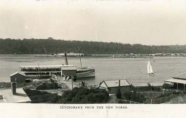 Lakes Entrance Historical Society
Postcard - SS Gippsland, Bulmer and Segerberg, c1912
Black and white postcard showing view of township. Background shows Kalimna escarpment. Middle ground shows historic Club Hotel on left. Foreground shows New Works buildings, school building, corner of Harbour Master's house on right. SS Gippsland at New Works wharf, with passengers. Small sailing boat on lake. Lakes Entrance VictoriaCunninghame from the New Worksjetties, township, boats and boating -
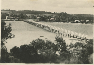 Lakes Entrance Historical Society
Postcard - Cunninghame Arm footbridge Lakes Entrance Victoria, H D Bulmer, 1940
Also two black and white postcards looking across footbridge to township 04271.1, 04271.2 size 9.5 x 14 cm 1940 cBlack and white postcard of Cunninghame Arm footbridge taken from the top of the sand dunes looking towards the few houses of Lakes Entrance Victoria Stamp on back The Lakes Studio Lakes Entrance. Also two black and white postcards looking across footbridge to township 04271.1, 04271.2 size 9.5 x 14 cm 1940 cbridges, recreational facilities, surf lifesaving, waterfront -
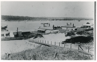 Lakes Entrance Historical Society
Photograph - Carpentertown, 1900c
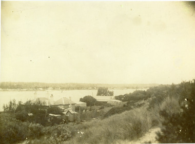
Also four other black and white copies, one size 12 x 18 cm, two size 9 x 14 cm, and one size 10 x 15 cm, one of which was purchased from Helen ClothierBlack and white photograph showing buildings on dunes, and township of Lakes Entrance across lake, Cunninghame Arm. Buildings from left are school, harbour masters house, harbour engineer's house. Boardwalk in foreground. Kalimna Hill in background. Lakes Entrance Victoriawaterways, vegetation, topography, township, historic buildings -
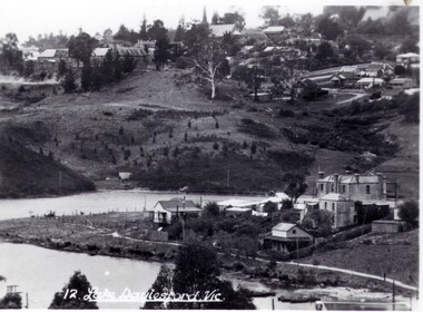
 Kiewa Valley Historical Society
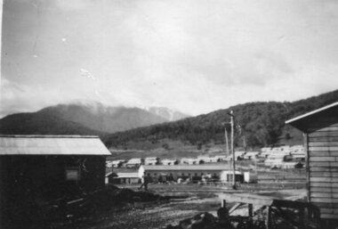
Photograph - Mount Beauty SEC Camp and Town, 1950
The new State Electricity Commission construction camp at the head of the Kiewa Valley was for workmen on the second power station in the project expected to be the most modern and best equipped in Australia… In contrast to the early Kiewa days of horses and canvas tents, the new camp, with its modern amenities, compared favourably with any country town. Administration of the Kiewa Scheme was moved from Tawonga to Mount Beauty in 1946. The first house in Mount Beauty, in Hollonds Street, was occupied by the co-op store manager from November 1946. The new Mess Hall at Mt Beauty was opened with much ceremony in early November 1946. The houses up to Nelse street were erected from 1946 onward and then the township was extended beyond Nelse Street in 1950. The workmen's camp was enlarged in 1950 to the extent of providing accommodation for a total of 1,200.Shows early construction in the town of Mt. Beauty surrounded by hills and farmland, with Mt Bogong in the background. Photo was taken in 1950 during the early stages of construction of the Kiewa Hydro electric SystemBlack and white photograph of Mt Beauty township in 1950 showing original workers buildings. Photograph has a .5cm white border around the photo.Handwritten on back of photograph in blue ink - SEC Camp and Town Mt Beauty 1950mt beauty, secv, mt beauty workmen's camp -
Phillip Island and District Historical Society Inc.
Newspaper clippings
Newspaper clipping on early history of San Remo and district, the naming of the township, San Remo Heights Estate Hall and the San Remo Post Office.Early history of San Remo, including its original settlement, surveying of the district, change of name from Griffiths Point proclaimed in the Victorian Government Gazette on 11th august, 1888. also early history of San Remo Heights Estate Hall and the San Remo Post Office. Includes a photograph of the township and fishing fleet probably taken from 1940 bridge.local history, documents, newspapers, san remo, buildings - historical, black & white newspaper clipping, san remo, post office, fishing fleet -
 Bendigo Historical Society Inc.
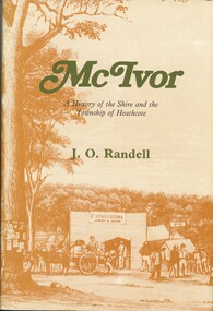
Book - MCIVOR, 1985
McIvor. A History of the Shire and the Township of Heathcote.J. O. Randell.history, australian, heathcote. -
 Clunes Museum
Photograph
VIEW OF SUSPENSION BRIDGE WITH TOWNSHIP IN THE DISTANCEsuspension bridge, local history -
 Ballarat Heritage Services
Photograph - Photograph - Black and White, Lake Daylesford
Lake Daylesford was created in 1929. The township of Daylesford surrounds Lake Daylesford.daylesford, murray views, lake daylesford -
 Ballarat Heritage Services
Image - Black and White, Broome, Western Australia, c1950, c1950
A black and white image of the township of Broome. broome, pearls -
 Ballarat Heritage Services
Image, Warrnambool, Victoria, c1918, c1918
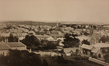
Black and white portrait of the Warrnambool township. .warrnambool -
 Ballarat Heritage Services
Photograph - Image - Black and White, City of Bendigo, c1918, c1918
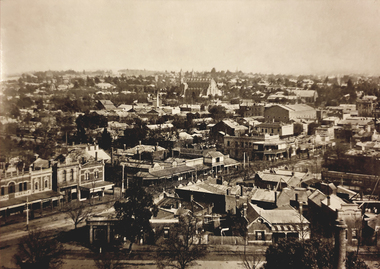
Bendigo is a goldfields town in Central Victoria.Black and white image of the township of Bendigo.george lansell, bendigo, fortuna, townscape -
 Ballarat Heritage Services
Photograph - Image - Black and White, City of Bendigo, c1918, c1918
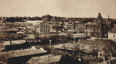
Bendigo is a goldfields town in Central Victoria.Black and white image of the township of Bendigo.bendigo, bendigo town hall -
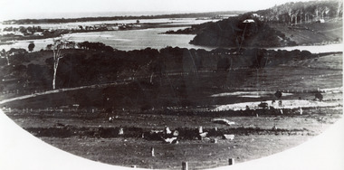
 Bendigo Historical Society Inc.
Photograph - MALMSBURY
DVD. Malmsbury Rail Viaduct. Township. -
Whitehorse Historical Society Inc.
Document, Recollections and notes on the history of Mitcham, n.d
1. John McClare, brief history of his settling in Australia in 18551. John McClare, brief history of his settling in Australia in 1855|2. Roll at St John's Catholic School Sep 30 1880, Jan 1 1886 and Mar 31 1888.History of Mitcham township. History of train journey from Mitcham to Melbourne.A copy of a second book is included as ND1522.1. John McClare, brief history of his settling in Australia in 1855mcclare, john, st johns catholic school, mitcham, mitcham, boxshall, hilda -
Bendigo Historical Society Inc.
Map - REDESDALE, See above
Map: two maps on either side of backing, (1) Township of Redesdale, Parish of Redesdale. (2) Surban lands, Parish of Spring Plains, County of Dalhousie. Date are 26th May 1873 and 12/07/1909 ( number 157 in Map Cupboard 1)map, dalhousie, township, redesdale, parish of spring plains, county of dalhousie -
 Lakes Entrance Historical Society
Photograph - Allen's Tearoom, 1935c
Enlarged from postcard produced for Mrs Allen to advertise Allens's Tearooms at the brow of Myer St, known as Allen's Hill.Black and white photograph of township, situated between Cunninghame Arm and North Arm. Shows cleared and fenced paddocks on eastern side of North Arm, some clearing and ring barked trees on western side, the high point sometimes referred to as Bernies Point after Bernie Sutherland, who lived and built boats here. Lakes Entrance VictoriaMrs Allens Seaview Cottage Lakes Entrancewaterways, topography, township, tearoom -
Port Melbourne Historical & Preservation Society
Plan - Sandridge Township, 1860, 1860
On back is handwritten - Nov 1860.Plan of Sandridge Township 1860 (Latrobe Library)Nov. 1860 (on rear)local government - municipal district of sandridge