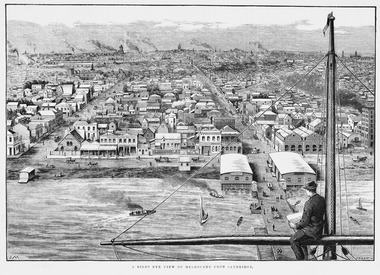
Showing 764 items matching " view point"
-
 Bendigo Historical Society Inc.
Photograph - Photos of Bendigo
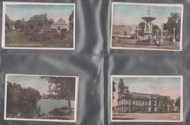
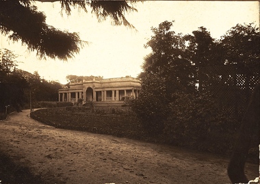
... . View Point from Mitchell Street, Bendigo - Alexandra Fountain... Prince Edward Alexandra Fountain Mitchell Street View Street ...Collection of nine photographs of iconic Bendigo locations. Cards are hand coloured and written on bottom of each is the name of the image and number of the photo. Photos are: 1. Alexandra Fountain Bendigo, looking up Mitchell Street towards Railway Station, behind Fountain. 2. Town Hall Bendigo. 3. The Conservatory Gardens, Bendigo with Law Courts in background. 4. The Swimming Pool, Bendigo commonly called the Municipal Baths. 5. View Point from Mitchell Street, Bendigo - Alexandra Fountain in foreground, 1930's vehicle on left hand side of image. 8. Queen Victoria Gardens, Bendigo - Queen Victoria statue in foreground. 9. King George Memorial Conservatory Gardens, Bendigo - statue of King George in middle of image, palm trees on left hand side. 10. Queen Victoria Gardens, Bendigo, looking up Pall Mall, Baby Health Centre on left hand side. bendigo, law courts, conservatory gardens, queen victoria, prince edward, alexandra fountain, mitchell street, view street -
 Bendigo Historical Society Inc.
Ephemera - Vintage Calendar of Bendigo. 2016
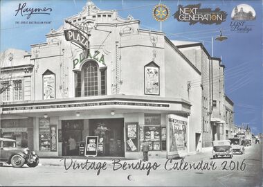
... , Gillies corner, 1960's; October, Jim Elvey's View Point Hotel...; September, Gillies corner, 1960's; October, Jim Elvey's View Point ...2016 Vintage Bendigo calendar. 12-month calendar. One historic image of Bendigo per month. January: Pall Mall, 1870's; February, Bendigo Mall, opened in 1981; March, aerial view of Bendigo Goal and Camp Hill, 1922; April, Easter Monday, Howard Place, 1903; May, 'Aldo's Auto Repairs', St. Andrews Avenue; June, Charing Cross, 1920's; July, Bendigo Municipal pool; August, Ordinance Factory, Shop Number 9, 1940's; September, Gillies corner, 1960's; October, Jim Elvey's View Point Hotel at Charing Cross; 1960's; November, Mitchell Street, 1950's; December, Pall Mall, 1940's. This calendar has not been used, and has no personal notations made on it. At the back are a list of Public Holidays for each state and territory, and a list of sponsors/advertisers, including Haymes, Rotary Club and Lost Bendigo.bendigo, business, calendar -
 Bendigo Historical Society Inc.
Photograph - T C WATTS & SON COLLECTION: CORNER SOMERVILLE AND ELLIS STS, BENDIGO, 1928
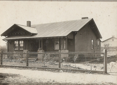
... in partnership as booksellers and stationers in a shop at View Point... in partnership as booksellers and stationers in a shop at View Point ...George Richard Oldfield was a butcher. Thomas Crouch Watts was born on March 7th. 1865, to Joseph and Susan Watts. Before the real estate business commenced, Thomas and his brother were in partnership as booksellers and stationers in a shop at View Point. Thomas lived in a fine house in Rowan Street, which was called 'Ottawa' Thomas started his real estate business in the early 1900s in a shop in View Street. His daughter Edna was the book keeper and typist, Stewart Watson was the salesman and Stanley Phipps (Edith Lunn's father) was the property manager and valuer. When Thomas Watts died in 1914, his daughter took over the running of the business. She married Stewart Watson in 1918. Eventually the name of the business was changed to Bishop and Earl. From a letter from Edith Lunn re T.C. Watts & Son. 'The firm of T.C. Watts & Son later became Bishop and Earl. When the firm of Bishop and Earl ceased to operate after the death of Edith Lunn's father, S.P. Bishop, Miss. June Parry, Secretary of the BHS was a member of staff. June rescued all the photos of properties listed for sale from the office and placed them into the custody of the BHS.' Black and white photograph mounted on rectangular grey board. House, weatherboard, corrugated iron roof, two chimneys. Dog at gate. Woven wire fence. Written on back of photo board " £850 Geo Oldfield, Cnr Somerville and Ellis St. Corner Somerville and Ellis Streets Bendigo, Cr ?on terms, Deposit required about £150' 2012 photo of house site attached to record for comparison.Frank A. Jeffree, Bendigoplace, building, residential, previous register no. ''mp12'' part of a collection of photographs used by estate agent t.c. watts and son -
 Kew Historical Society Inc
Photograph - Flooding of the Yarra River in North Kew, 1934
... . The point of view is from a backyard looking towards Fairfield. .... The point of view is from a backyard looking towards Fairfield ...North Kew, now divided between Kew and Kew East, bordered the Yarra River. As such, it was a region subject to flooding in the Yarra Valley. Development beyond this point (ie Kellett Grove) was limited by the City of Kew's planning regulations. Prior to urban development, the area since European settlement and the first land sales in the district in the 1840s, had been used for dairy farming. Small sepia snapshot taken from the back yard of a house at 8 Kellett Grove, in what was then known as North Kew. The point of view is from a backyard looking towards Fairfield. Verso: 8 KELLETT GROVEyarra river -- north kew, floods -- yarra valley, floods -- north kew, floods -- 1934, natural disasters -- kew -
 Kew Historical Society Inc
Photograph - Flooding of the Yarra River in North Kew, 1934
... . The point of view is from a backyard looking towards Fairfield. ... as North Kew. The point of view is from a backyard looking towards ...North Kew, now divided between Kew and Kew East, bordered the Yarra River. As such, it was a region subject to flooding in the Yarra Valley. Development beyond this point (ie Kellett Grove) was limited by the City of Kew's planning regulations. Prior to urban development, the area since European settlement and the first land sales in the district in the 1840s, had been used for dairy farming. Small sepia snapshot taken from the back yard of a house at 8 Kellett Grove, in what was then known as North Kew. The point of view is from a backyard looking towards Fairfield. Verso: OUR BACKYARD 8 KELLETT GROVEyarra river -- north kew, floods -- yarra valley, floods -- north kew, floods -- 1934, natural disasters -- kew -
 Glenelg Shire Council Cultural Collection
Booklet - Booklet - Historical Portland Souvenir, Victoria, Nov-22
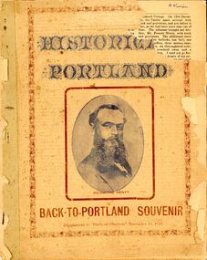
... Battery Point, and Portland coast view from Lighthouse Point... Battery Point, and Portland coast view from Lighthouse Point ...Twenty-four page booklet 'HISTORICAL PORTLAND', a Back-to-Portland souvenir supplement to 'Portland Observer', November 16, 1922. Likeness of Edward Henty on front page, Portland Bay from Battery Point, and Portland coast view from Lighthouse Point, on back. -
 Lakes Entrance Historical Society
Photograph - Jemmys Point Lakes Entrance, 1880 c
... Colour photograph print of early painting of view from... of early painting of view from Jemmys Point towards Metung showing ...Colour photograph print of early painting of view from Jemmys Point towards Metung showing paddle steamer and Aboriginals in bottom left hand corner Rigby Fraser and Flannagan Islands centre of painting, The Barrier on the left Nungurner Hills on right Gippsland LakesEntrance to The Gippsland Lakesaerial photograph, township, topography, jemmys point lakes entrance -
 Bendigo Historical Society Inc.
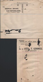
Document - KELLY AND ALLSOP COLLECTION: COLLECTION OF BUSINESS ACCOUNT FORMS (UNUSED), 1900- 1920
... Manufacturer, View Point Timber Yard, Eaglehawk; l. J Shadbolt... Brown, Brick & Tile Manufacturer, View Point Timber Yard ...COLLECTION OF BUSINESS ACCOUNT FORMS (UNUSED)a. Thomas Brown, Steam Chaff-Cutting Works, Campbells Forest; b. Chas T Gemmill, Cash Grocer, Sailors Gully; c. Stewart, Scott & Co., Millers & Grain Merchants, Bendigo; d. W P Gilbert, Cash Draper, Eaglehawk; e. w p Gilbert; f. J H Webster, Butcher, Eaglehawk; g. H M Sampson, Bootmaker and Importer, Neangar Boot Store; h. Bendigo & Eaglehawk Master Butchers' Association, Eaglehawk; I B Costa, Fruiterer & Confectioner, Italian Café,Eaglehawk; j. Hospital Sunday Committee, Eaglehawk; k. W E Brown, Brick & Tile Manufacturer, View Point Timber Yard, Eaglehawk; l. J Shadbolt, Wholesale and Family Butcher, Sydney Fllat; m. S J Millar, Bread Manufacturer, California Hill; n. A. Betts, Bricklayer and Contractor, California Gully; o. S J Williams, Copperplate Cleaner etc. California Gully.organization, business, bendigo businesses -
 Ballarat Tramway Museum
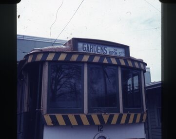
Slide - 27 mm sq slide/s - destination roll, Lilian Butler, Sep. 1971
... - Gardens via Drummond Nth .15 - View Point .16 - Gregory St .17... - Special .14 - Gardens via Drummond Nth .15 - View Point .16 ...Yields information about the destination rolls and the locations shown on a roll on a Ballarat Tram.Set of 22 Colour 27 x 27 mm slide in Agfachrome blue and white plastic mounts showing various destinations on tram No. 12 parked on the depot fan. .1 - Gardens via Ripon St .2 - Grey St Sebastl (Sebastopol) .3 - Sebastopol .4 - City .5 - Victoria St .6 - Gardens via Sturt St West .7 - Mt Pleasant .8 - Depot .9 - Bell St .10 - Haddon St via Drummond Nth .11 - Depot via Drummond Nth .12 - City Oval .13 - Special .14 - Gardens via Drummond Nth .15 - View Point .16 - Gregory St .17 - Drummond St Nth .18 - Rubicon St .19 - Depot via Ripon St .20 - Grey St Sebastopol .21 -Sturt St West .22 - Special (Depot - on tram 32 with an "Pay as you Enter" inside the depot building. Photo from the collection of Lilian Butler. ballarat, tramways, trams, depot, sec depot, destination indicators, destination roll, tram 12, tram 32 -
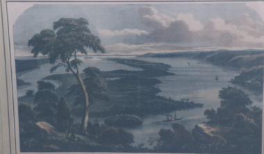
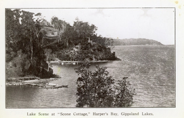 Lakes Entrance Historical Society
Photograph - Scone Cottage, 1920c
... tourist venue, run by Mrs Westerson. Distant view of Jemmys Point... by Mrs Westerson. Distant view of Jemmys Point. Lakes Entrance ...Copied from a postcardBlack and white photograph of Harpers Bight, Gippsland Lakes. It shows rustic jetty in foreground with boat moored, jetty below zigzag pathway to Cliff Crest Tea Rooms, a popular tourist venue, run by Mrs Westerson. Distant view of Jemmys Point. Lakes Entrance VictoriaLakes Scene at Scone Cottage, Harpers Bay, Gippsland Lakes tearoom, tourism, waterways -
 Mission to Seafarers Victoria
Print - Wood engraving, F.A. Sleap, A Bird's-eye View Of Melbourne From Sandridge, 2 September 1885
... a seamen's point of view on board a ship.... a seamen's point of view on board a ship. This engraving is a rare ...The illustration published in the Illustrated Australian News (Melbourne, Vic. : 1876 - 1889), p. 144, on 2 September 1885, depicts Sandridge now Port Melbourne in 1885 from a seamen's point of view on board a ship.This engraving is a rare depiction fo the Bethel church as there is no early photograph. The Sailors' Rest is located at the back. In 1887, the church was demolished to erect the building still standing on the corner of Nott Street and Beach Road.Copy of an engraving depicting a sailor sitting on the mast of the ship and looking at the shore from the sea. A Bird's-eye View Of Melbourne From Sandridge.nott street, sandridge, melbourne, port melbourne, beach road, seamen, ships, sails, sailing ships, customs house, bethel church -
 Villa Alba Museum
Photograph - Drawing Room, Villa Alba, 2011
... . The photographer's point of view includes the original Carrara marble.... The photographer's point of view includes the original Carrara marble ...Built between 1882 and 1884 for the banker William Greenlaw and with interior decoration by the Paterson Brothers, a number of elements of the the interior design scheme reference Greenlaw’s Scottish origins. Following his death in 1895, from 1897 the house was leased and owned by a succession of owners including the Fripp family, the Royal Women’s Hospital and the Mount Royal Hospital before being sold to the Society of Jesus for Xavier College. In 2004 the title was transferred to Villa Alba Museum Inc., and the western section of the garden leased to Xavier College for 99 years. The photograph is one of a series of views of the interior commissioned from the photographer Russell Winnell by the Board of Management of Villa Alba Museum in 2011.The Drawing Room at Villa Alba, 44 Walmer Street, Kew. The photographer's point of view includes the original Carrara marble fireplace and satinwood over-mantel in the panoramic view of the south-facing room. villa alba museum, interior design - 19th century, drawing rooms - 19th century, paterson brothers - decorators - melbourne, russell winnell photography -
 Kew Historical Society Inc
Photograph - 'Southesk' (formerly 'Ordsall'), Cotham Road, 1920s
... of the house can be seen surrounded by an extensive garden. The point... by an extensive garden. The point-of-view of the camera is from Cotham ...Ordsall was originally built for John Halfey, second Chairman of Kew, and sold after his death to the Carnegie family who renamed it ‘South Esk'. The Carnegie family mounted a defence of their property when the City of Kew sought to compulsorily acquire the site for a new town hall in the 1930s. The house and land were later acquired by Council in 1947 and demolished in 1970. The present Kew Library and the former Council Offices (now owned by Trinity Grammar) are located on the site.One of the earliest photographs of 'Southesk' and its gardens. The house was of statewide significance because of its historical association with John Halfey. It was artistically significant due to its elaborate interiors, decorated by Cullis Hill & Co in the 1880s. Sepia photograph mounted on brown card of "Southesk' (formerly known as 'Ordsall'). The single-storey Italianate facade of the house can be seen surrounded by an extensive garden. The point-of-view of the camera is from Cotham Road.john halfey, david carnegie, southesk - south esk - ordsall -
 Kew Historical Society Inc
Photograph - 'Southesk' (formerly 'Ordsall'), Cotham Road, 1920s
... of the house can be seen surrounded by an extensive garden. The point... by an extensive garden. The point-of-view of the camera is from Cotham ...Ordsall was originally built for John Halfey, second Chairman of Kew, and sold after his death to the Carnegie family who renamed it ‘South Esk'. The Carnegie family mounted a defence of their property when the City of Kew sought to compulsorily acquire it as the site for a new town hall in the 1930s. The house and land were later acquired by Council in 1947 and demolished in 1970. The present Kew Library and the former Council Offices (now owned by Trinity Grammar) are located on the site.One of the earliest photographs of 'Southesk' and its gardens. The house was of statewide significance because of its historical association with John Halfey. It was artistically significant due to its elaborate interiors, decorated by Cullis Hill & Co in the 1880s. Sepia photograph mounted on brown card of "Southesk' (formerly known as 'Ordsall'). The single-storey Italianate facade of the house can be seen surrounded by an extensive garden. The point-of-view of the camera is from Cotham Road.john halfey, david carnegie, southesk - south esk - ordsall -
 Kew Historical Society Inc
Photograph - 'Southesk' (formerly 'Ordsall'), Cotham Road, 1920s
... of the house can be seen surrounded by an extensive garden. The point... by an extensive garden. The point-of-view of the camera is from Cotham ...Ordsall was originally built for John Halfey, second Chairman of Kew, and sold after his death to the Carnegie family who renamed it ‘South Esk'. The Carnegie family mounted a defence of their property when the City of Kew sought to compulsorily acquire it as the site for a new town hall in the 1930s. The house and land was later acquired by Council in 1947 and demolished in 1970. The present Kew Library and the former Council Offices (now owned by Trinity Grammar) are located on the site.One of the earliest photographs of 'Southesk' and its gardens. The house was of statewide significance because of its historical association with John Halfey. It was artistically significant due to its elaborate interiors, decorated by Cullis Hill & Co in the 1880s. Sepia photograph mounted on brown card of "Southesk' (formerly known as 'Ordsall'). The single-storey Italianate facade of the house can be seen surrounded by an extensive garden. The point-of-view of the camera is from Cotham Road.john halfey, david carnegie, southesk - south esk - ordsall -
 Kew Historical Society Inc
Photograph - 'Southesk' (formerly 'Ordsall'), Cotham Road, 1920s
... of the house can be seen surrounded by an extensive garden. The point... by an extensive garden. The point-of-view of the camera is from Cotham ...Ordsall was originally built for John Halfey, second Chairman of Kew, and sold after his death to the Carnegie family who renamed it ‘South Esk'. The Carnegie family mounted a defence of their property when the City of Kew sought to compulsorily acquire it as the site for a new town hall in the 1930s. The house and land were later acquired by Council in 1947 and demolished in 1970. The present Kew Library and the former Council Offices (now owned by Trinity Grammar) are located on the site.One of the earliest photographs of 'Southesk' and its gardens. The house was of statewide significance because of its historical association with John Halfey. It was artistically significant due to its elaborate interiors, decorated by Cullis Hill & Co in the 1880s. Sepia photograph mounted on brown card of "Southesk' (formerly known as 'Ordsall'). The single-storey Italianate facade of the house can be seen surrounded by an extensive garden. The point-of-view of the camera is from Cotham Road.david carnegie, john halfey, southesk - south esk - ordsall -
 Kew Historical Society Inc
Photograph - Flooding of the Yarra River in North Kew, 1934
... Grove, in what was then known as North Kew. The point of view.... The point of view is from a backyard looking towards Fairfield ...North Kew, now divided between Kew and Kew East, bordered the Yarra River. As such, it was a region subject to flooding in the Yarra Valley. Development beyond this point (ie Kellett Grove) was limited by the City of Kew's planning regulations. Prior to urban development, the area since European settlement and the first land sales in the district in the 1840s, had been used for dairy farming. Small sepia snapshot of floodwaters taken from near Kellett Grove, in what was then known as North Kew. The point of view is from a backyard looking towards Fairfield. In the foreground ar two men in a rowboat.Verso: OUR BACKYARD / Stamped 3 163yarra river -- north kew, floods -- yarra valley, floods -- north kew, floods -- 1934, natural disasters -- kew -
 Kew Historical Society Inc
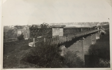
Photograph, Railway Viaduct, c.1919
... . The point-of-view of the photograph shows Kew in the distance. ... traffic. The point-of-view of the photograph shows Kew ...The railway viaduct linking Kew and Fairfield was created for the Outer Circle railway.Railway viaduct, Yarra River, linking Kew and Fairfield. Built by John Monash for the Outer Circle Railway. In 1930 converted into the Chandler Highway Bridge for vehicular traffic. The point-of-view of the photograph shows Kew in the distance. Annotations on reverse: "Outer Circle Railway Bridge (now Chandler Highway) Fairfield-Kew, about 1919. Property of Miss Foley.outer circle railway, railway viaduct (kew), john monash -
 Lakes Entrance Historical Society
Photograph - The Entrance, 1924c
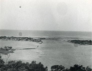
... Black and white photograph showing view from Jemmys Point... view from Jemmys Point of the entrance, with wooden piers, PWD ...Black and white photograph showing view from Jemmys Point of the entrance, with wooden piers, PWD houses and works buildings at New Works. West end of Bullock Island on left side of photo, bathing boxes and some trees on island, some rock groyne work at the entrance. Lakes Entrance Victoriapiers, islands, houses -
 University of Melbourne, Burnley Campus Archives
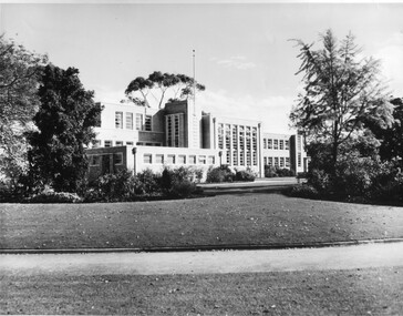
Photograph - Black and white print, Publicity Branch Victorian Department of Agriculture, Administration Building, 1958
... viewed from South East point across lawns. Prominent tree... viewed from South East point across lawns. Prominent tree ...Note by T.H. Kneen 19 November 1991, "The Ginkgo biloba died subsequently and was replaced by another tree in the same area. The replacement is a Liriodendron tulipifera planted by the Minister for Agriculture Mr Kent on Arbor Day 1982. (This tree has been replaced by a G. biloba twice more in slightly different places).4 copies black and white photograph. East side of building viewed from South East point across lawns. Prominent tree at right is Ginkgo biloba. Also small print taken from large photo.On reverse, "Received at Burnley March 1958," and, "Photograph by Publicity Branch Victorian Department of Agriculture Ref. No. B1418."lawns, trees, ginkgo biloba, minister for agriculture, arbor day, 1982, minister for agriculture mr kent, administration building, main building, emily gibson beds, liriodendron tulipifera -
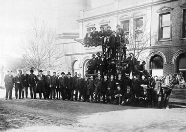 Ballarat Tramway Museum
Photograph - Black & White Photograph/s, c1915?
... and tramway staff outside the front of the ESCo Power Station, View... the front of the ESCo Power Station, View Point, Wendouree Parade ...Has a strong association with the ESCo shed staff and later tram crews, c1910? Shows the nature of the clothing worn by the depot staff, and one of the crew and the interior detail of the one of the tramcars at the time. Provides details of names of some of the men photographed.Black and White copy photograph of the ESCo power station and tramway staff outside the front of the ESCo Power Station, View Point, Wendouree Parade, Ballarat c1915. Standing on the ground are 26 men and on the tower truck a further 14 men. Shows details of the clothing the men were wearing at the time, depending on the age and company position, details of the horse drawn tower truck, and of the power station and office brickwork. Tower wagon drawn by one Clydesdale horse. See page 53 of The Golden City and its Tramways and for the photo itself. Gives some names of the people in the photograph. From the photo caption in the book: Extreme left Harry Foy, depot Foreman, second from left Mr Knox the accountant; third from left is Walter J.K. Dunstan, office manager, 7th from left Alan Todd, 3rd from right standing is Bob Tregaskis ("Rickety Bob), at left, kneeling is Albert Mitchell, at right kneeling is George Laurens - overhead wire maintenance, standing at base of the tower at right is Tom Richardson, painter, next to him on the left is Sy Barker and at the reins Teddy Hewitt and Harry Weston.tramways, trams, esco, staff, power station, tower wagon -
 Kew Historical Society Inc
Photograph - Flooding of the Yarra River in North Kew, 1934
... . The point of view is from a backyard looking towards Fairfield.... The point of view is from a backyard looking towards Fairfield ...North Kew, now divided between Kew and Kew East, bordered the Yarra River. As such, it was a region subject to flooding in the Yarra Valley. Development beyond this point (ie Kellett Grove) was limited by the City of Kew's planning regulations. Prior to urban development, the area since European settlement and the first land sales in the district in the 1840s, had been used for dairy farming. Small sepia snapshot taken from the back yard of a house at 8 Kellett Grove, in what was then known as North Kew. The point of view is from a backyard looking towards Fairfield. Floodwaters have submerged the fence and a clothes line. Verso: BACKYARD NTH. KEWyarra river -- north kew, floods -- yarra valley, floods -- north kew, floods -- 1934, natural disasters -- kew -
![Cumberland Creek, near Point Sturt / [by] Nicholas Caire, circa 1876](/media/collectors/550653872162f11fb04854aa/items/57834713d0cdd1176c71111b/item-media/57834799d0cdd1176c71e113/item-fit-380x285.jpg) Kew Historical Society Inc
Kew Historical Society IncPhotograph, Anglo-Australasian Photographic Company, Cumberland Creek, near Point Sturt, c. 1876
... ‘Cumberland Creek, near Point Sturt’ : Views of Victoria... no other vegetation can be found.’ ‘Cumberland Creek, near Point ...Nicholas Caire was born on Guernsey in the Channel Islands in 1837. He arrived in Adelaide with his parents in about 1860. In 1867, following photographic journeys in Gippsland, he opened a studio in Adelaide. From 1870 to 1876 he lived and worked in Talbot in Central Victoria. In 1876 he purchased T. F. Chuck's studios in the Royal Arcade Melbourne. In 1885, following the introduction of dry plate photography, he began a series of landscape series, which were commercially successful. As a photographer, he travelled extensively through Victoria, photographing places few of his contemporaries had previously seen. He died in 1918. Reference: Jack Cato, 'Caire, Nicholas John (1837–1918)', Australian Dictionary of Biography.An original, rare photograph from the series 'Views of Victoria: General Series' by the photographer, Nicholas Caire (1837-1918). The 60 photographs that comprise the series were issued c. 1876 and reinforced a neo-Romantic view of the Australian landscape to which a growing nationalist movement would respond. Nicholas Caire was active as a photographer in Australia from 1858 until his death in 1918. His vision of the Australian bush and pioneer life had a counterpart in the works of Henry Lawson and other nationalist poets, authors and painters.‘Cumberland Creek, near Point Sturt’ : Views of Victoria (General Series) No.59 : Albumen silver photograph | Photo on card with Title and Description on reverse | Mounted 24 x 30 cm; Photo 12 x 17 cm.On Reverse: ‘The Cumberland Creek is so named from the close resemblance it bears to the place bearing that name in the mother country. The present illustration represents the precipices and hills which surround the Cumberland Creek. The soil around the hills is mostly sandstone rubble, hence the only vegetation identical with the spot is the inevitable sword grass and salt scrub, which frequently exist where no other vegetation can be found.’nicholas caire (1837-1918), landscape photography -
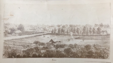 Kew Historical Society Inc
Print, Jenny Rudolph, Kew
... The point of view of the artist is looking towards Kew from... The point of view of the artist is looking towards Kew from ...The point of view of the artist is looking towards Kew from the vicinity of Xavier College. The paddocks in the foreground are bordered by Wellington Street. In the distance the towers of the asylum can be see, further narrowing the date to after 1870s. The work exists in a number of original versions including a colour print.Kew, ca. 1870 - ca. 1880. Reproduction of a book plate from an original wood engraving, of an elevated view of trees and paddocks with a town in the background. The illustration is signed R. JENNY Sc. [Rudolph Jenny 1827-1905, lithographer.] A version from which this reproduction may have been made was donated to the State Library of Victoria by the National Trust, Victoria in 1985. kew (victoria), wellington street -- kew (vic.) -
 Bendigo Historical Society Inc.
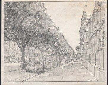
Drawing - WES HARRY COLLECTION: PALL MALL, 1972
... Pencil drawing called Pall Mall Bendigo. The point of view... W.C. Harry Pencil drawing called Pall Mall Bendigo. The point ...Pencil drawing called Pall Mall Bendigo. The point of view is looking down the footpath in front of the law Courts and Post Office, these are on the right hand side. On the left of Pall Mall , Stonemans supermarket can be seen as well as the Myer store.W.C. Harrydrawing, pencil, pall mall, pall mall, drawings, stonemans supermarket -
 Whitehorse Historical Society Inc.
Article, Review board meets council, 1994
... listening as Nunawading Mayor, Kevin Abbott explains Council's point... explains Council's point of view re amalgamation. LGB Board members ...Local government Board Chairman, Leonie Burke is pictured listening as Nunawading Mayor, Kevin Abbott explains Council's point of view re amalgamation.Local government Board Chairman, Leonie Burke is pictured listening as Nunawading Mayor, Kevin Abbott explains Council's point of view re amalgamation. LGB Board members also visited Box Hill and Ringwood councils on the same day.Local government Board Chairman, Leonie Burke is pictured listening as Nunawading Mayor, Kevin Abbott explains Council's point of view re amalgamation.city of nunawading, city of box hill, city of ringwood, amalgamations, local government, abbott, kevin, mayors, burke, leonie, macdonald, terry, broadbent, russell -
Bendigo Historical Society Inc.
Book - VISION SPLENDID BENDIGO, 1986
... , Alexandra Fountain, Commercial Bank View Point, State Bank, St.... John’s Church, Alexandra Fountain, Commercial Bank View Point ...Vision Splendid Bendigo. Cream coloured paper 56 pages, with line drawings of landmark buildings of Bendigo. Drawings by Jan Neil. Vision Splendid Introduction, Wesleyan Church Golden Square, Sacred Heart Cathedral, Central Deborah Mine, Marlborough House, Fuse factory, Goldmines Hotel, Fortuna Villa, Bon Accord, Heinz Butcher Shop, Long Gully State School, California Gully State School, Stone cottage Harvey Town, Eaglehawk Town Hall, Caradon, Eaglehawk State School, Victoria Hotel, Bendigo Pottery, Eucalyptus Distillery, St Luke’s, Lake Weeroona, Joss House, Benevolent Home, Lansellstowe, Kaithness, Malmo Valentine Street, Dudley House, Rifle Brigade Hotel, Fire Station, Masonic Hall, Temperance Hall, Old Post Office, Wesley Church, St. John’s Church, Alexandra Fountain, Commercial Bank View Point, State Bank, St Paul’s Cathedral Railway Station, National Bank, Town Hall, Post Office, Shamrock Hotel, Camp Hill State School, Police Barracks, Law Courts, Specimen Cottage, Technical College, St. Kilian’s Church, Tram Depot, St. Aidan’s OrphanageJan Neilbendigo, buildings, heritage buildings, heritage, heritage buildings, bendigo. -
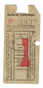 Ballarat Tramway Museum
Ephemera - Ticket/s, Electric Supply Co. of Vic (ESCo), ESCo 1d ticket, late 1920's?
... and Gregory St (via Lydiard) Hello Warren, The View Point...) Hello Warren, The View Point line leaves Sturt St and turns ...Demonstrates how ESCo managed Weekly tickets during the late 1920's and yields information about the way the system was arranged. The source of the ticket, NSW tramways is significant in that it was obtained by them as a sample.One penny or 1d paper ticket, ESCo, Ballarat Tramways, printed on fawn paper, No. D3339. Ticket has up and down directions, conditions of use, not issued on public holidays, special cars or railway picnic days. Front of the ticket (with the number), has it available for: Bridge and Drummond St Sturt St and Macarthur St Macarthur St (Junction Wendouree Parade and Gardens) On the rear - the ticket is made available for use by a child in the following: Orphanage and Grenville St Mt Pleasant and Grenville St Bridge St and Service St {stop along Sturt St West} Bridge St and Macarthur (via Fraser St) {Alan Bradley advised 29/6/14 by email, former name of Ripon St North once it crossed over Mair St heading north. - see note below} Sturt St and Gregory St (via Lydiard) Hello Warren, The View Point line leaves Sturt St and turns into Ripon St. It crosses Mair St, does a dogleg, and went into Fraser St. then past the Powerhouse. The descriptions of the horse tram lines to be constructed by the BTCo, and the electric lines to be constructed by the ESCo, specify that the lines run along Ripon and Fraser Sts. Alantrams, tramways, tickets, esco, children -
 Bendigo Historical Society Inc.
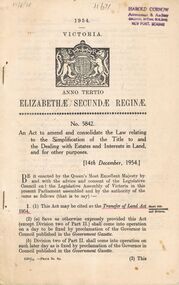
Book - 1954 VICTORIA ANNO TERTIO ELIZABETHÆ SECUNDÆ REGINÆ NO. 5842, 17/8/56
... Building View Point, Bendigo... Accountant & Auditor Colonial Mutual Building View Point, Bendigo ...A small book owned by Accountant & Auditor Harold Curnow detailing the "Simplification of Title to and the Dealing with Estates and Interests in land for for other purposes", it also has the date 17/8/56 written in pencil on the top left corner. The first page is written as following. "17/8/56 Harold Curnow Accountant & Auditor Colonial Mutual Building View Point, Bendigo 1954 VICTORIA ANNO TERTIO ELIZABETHÆ SECUNDÆ REGINÆ No. 5842. An Act to amend and colidate the law relating to the Simplification of the title to and the Dealing with Estates and interests in Land and for other purposes. [14th December, 1954.] Be it enacted by the Queen's most Execellent Majesty by and with the advice and consent of the Legislative Council and the Legislative Assembly of Victoria in this present Parliament assembled and by the authority of the same as follows (that is to say) 1. (1) this Act may be cited as the Transfer of Land Act 1954. (Short title commencement and division) (2) (a) Save as otherwise ecpressly provided this act (except Division two of Part II.) shall come into operation on a day to be fixed by proclamation of the Governor in Council published in the Goverment Gazette. (b) Division two of Part II. shall come into operation on such later day as is fixed by proclamation of the Governor in Council published in the Goverment Gazette 6325/55 -Price 3s. 9d. (3) This"victoria -
 Ballarat Tramway Museum
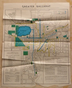
Map, Greater Ballarat Association and George Netherway, "Map of Ballarat", c1950
... and drawn in black ink the branch of the View Point tram line!...) Someone's come along and drawn in black ink the branch of the View ...Yields information about Greater Ballarat, including trams, buses, locations and streets. Has a strong association with George Netherway.Four colour map of Ballarat, showing streets, places of interest, Parks, tram routes, bus routes, railway lines, prepared by G. C. Netherway, Greater Ballarat Association. Shows suburbs names, location of places of interest, some development north of Howitt St, in Wendouree. Map is part diagrammatic and is not entirely to scale. Includes the Lake Wendouree Rowing course On rear is a road map of the Ballarat area, lists of statistics, beauty spots, look outs, art and culture, points of historical interest, industrial products and recreation. Printed by Waller & Chester on paper produced by Ballarat Paper Mills Pty Ltd. See Reg item 2074 for photographic image of this version of the map. See Reg Item 2776 for another version of this map. Contained originally within Reg Item 5507 at the back of the binder. For items see btm5507 loose items list.pdf John Whiting in an email of 17-9-2021 noted: The rowing course along Lake Wendouree is noted, so perhaps this map is post 1956? The Mt Pleasant tram line is shown to terminate at Morton St, not Cobden St (which of course is incorrect) Someone's come along and drawn in black ink the branch of the View Point tram line!trams, tramways, ballarat, tram routes, bus routes, map, lists