Showing 14217 items matching "2016-01-30"
-
 Ballarat Heritage Services
Photograph - Colour, Australian Natives Association Ballarat Foundation Stone, 2016, 30/07/2016
Australian Natives Association Ballarat Branch No. 4 Foundded 1874 This stone was laid by Victor L. Ginn Esq Chief President March 17th 1925. -
 Ballarat Heritage Services
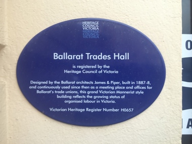
Photograph - Colour, Ballarat Trades Hall Plaque, 2016, 30/07/2016
Ballarat Trades Hall is registered by the Heritage Council of Victoria Designed by the Ballarat architects James and Piper, built in 1887-8, and continuously used since then as a meeting place and offices for Ballarat's trade unios, this grand Victorian Mannerist style bilding reflects the rowing status of organised labour in Victoria Victorian Heritage Register Number H0657ballarat trades hall, camp street, unions, foundation stone, plaque, brett edgington, paul clempson -
 Ballarat Heritage Services
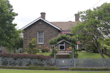
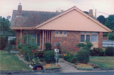
Digital photograph, Lisa Gervasoni, Bluestone House, Portland, 2016, 30/12/2016
Photograph of a bluestone house near the site of the former Immigration Depot.portland, heritage, bay, water, beach, bridgewater -
 Ballarat Heritage Services
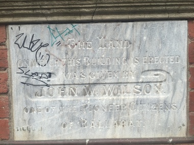
Photograph - Photograph - Colour, Clare Gervasoni, YMCA Ballalrat, 2016, 30/07/2016
At one time pre-service teachers' of the Ballarat Teachers' College boarded at the YMCA. There also used to be an inside pool at the site. Three photographs relating to the YMCA Ballarat building, including the Foundation stone. The land on which this building is erected was given by John W. Wilson one of the pioneer citizens of Ballaratymca, young mens christian association, foundation stone, camp street, ballarat, john w. wilson -
 Ballarat Heritage Services
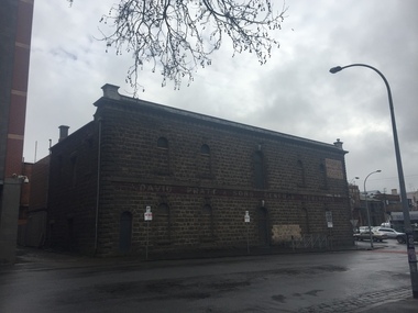
Photograph - Photograph - Colour, Pratt's Warehouse, Camp Street, Ballarat. 2016, 30/07/2016
Colour photograph of a souble storey bluestone warehouse in Camp Street, Ballarat.pratt's warehouse, bluestone, camp street, ballarat -
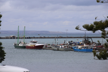 Ballarat Heritage Services
Photograph - Photograph - Colour, Port of Portland, 2016, 30/12/2016
A number of boats at the Port of Portland, Victoriaportland, port -
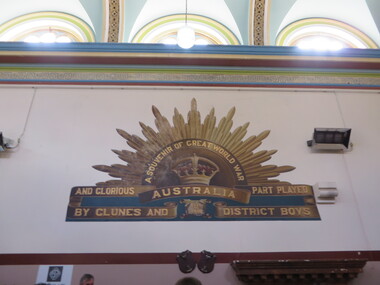 Ballarat Heritage Services
Photograph - Photograph - Colour, Interior of Clunes Town Hall, 2016, 30/04/2016
The painted interior of the Clunes Town Hall is a war memorial A number of colour photographs showing the ipainted nterior of the Clunes Town Hall, including the World War One memorial which includes a rising sun painted onto an interior wall.clunes town hall, world war one memorial, rising sun, aif, architecture, clunes -
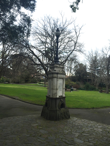 Ballarat Heritage Services
Photograph - Colour, Clare Gervasoni, Queen Victoria Jubilee Fountain, Alexandra Gardens, Kew, 2016, 30/07/2016
queen victoria jubilee, fountain, kew, alexandra gardens -
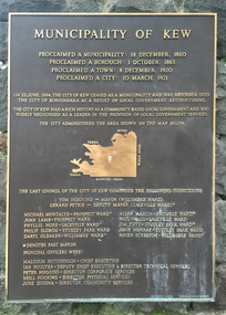 Ballarat Heritage Services
Photograph - Colour, Clare Gervasoni, Municipality of Kew Plaque at the Entrance of Alexandra Gardens, Kew, 2016, 30/07/2016
On 22 June 1994 the City of Kew ceased as a municiplity and was absorbed into the City of Boroondara as a result of local government restructuring. The City of Kew has a rich history as a commnity based local government and was widely revognised as a leader in the provision of local government services. Colour photograph of the Municipality of Kew plaque at the entrance of Alexandra Gardens, Kew.kew, alexandra gardens, city of kew, kew municipality, council amalgmation -
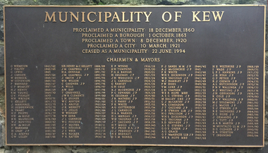 Ballarat Heritage Services
Photograph - Photograph - Colour, Clare Gervasoni, City of Kew Chairmen and Mayors Plaque at the Entrance of Alexandra Gardens, Kew, 2016, 30/07/2016
On 22 June 1994 the City of Kew ceased as a municiplity and was absorbed into the City of Boroondara as a result of local government restructuring. The City of Kew has a rich history as a commnity based local government and was widely revognised as a leader in the provision of local government services. Colour photograph of a plaque showing the names of the City of Kew Chairmen and Mayors plaque at the entrance of Alexandra Gardens, Kew.kew, alexandra gardens, city of kew, kew municipality, council amalgmation, h.e. wiltshire, ivan wade, l.f.i. hawkins, jack ryan, j.d. ryan, gerrie petrie, dick cremin, r.j. cremin, alan hutchinson, p.n.v. wallinga, noel whiting, martin solomons, j.l. mccue, john hogan gervasoni, kaye cole, s.k. o'brien, r.e. saunders, phyllis hore, joe ormando, j.l. tutt, a.a.b. martin, m. montalto, d.g. oldaker, r.a. streeton, t. indovino, f. barnard, s.s. argyle, j.l. carnegie, f.r> ratten, a.j. mcconchie, jack gervasoni, j.h. gervasoni, s. kellett -
 Ballarat Heritage Services
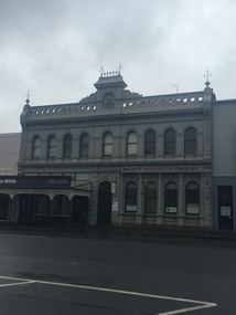
Photograph - Photograph - Colour, Nevett Wilkinson Frawley, Lydiard Street South, Ballarat, 2016, 30/07/2016
Colour photographs of a double storey building in Lydiard Street South, Ballarat.architecture, nevett wilkenson frawley -
 Eltham District Historical Society Inc
Photograph, Buda, Castlemaine, Spring Gardens Excursion, 30 October 1988, 30 Oct 1988
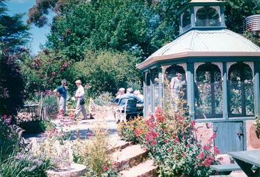
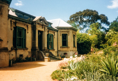
Pam and Marion EDHS Newsletter No. 62, September, 1988 SPRING GARDENS TRIP 30 Oct 1988 On this trip we will be visiting gardens which are of historic interest or of old world character. The date has been selected to coincide with the time when the gardens are likely to be at their best. The Central Victorian Goldfields area has been selected because it offers a wide range of gardens open to the public. From this range we have chosen three gardens which we think will be of great interest to members and their families and friends. These are the gardens: • "Buda", Castlemaine One of Victoria's most famous historic gardens. The mansion which was the home of the Leviny family for 118~ years is also open for inspection. • "Badger's Keep", Chewton This is a cottage garden (complete with 100 year old cottage) with a great diversity of plants. • "The Springs", Sedgwick A country garden also with a great array of plants The cost of the bus is $9.00 for adults and $5.00 for children. There is an additional charge for entry to the gardens, $2.00 each for "Badger's Keep" and "The Springs": for "Buda" it is $3.00, $1.50 for pensioners and $1.00 for children Each of the gardens has plants for sale. Bring your own picnic lunch. Please be at the Eltham Shire Offices by 8.15 a.m. so we can leave promptly at 8.30. To book for this trip complete the attached form and return the appropriate fare. EDHS Newsletter No. 63, November, 1988 RECENT ACTIVITIES More recently the Spring Gardens trip attracted a full bus load and a waiting list. Those who went thoroughly enjoyed the historic garden and mansion at "Buda" and two other excellent gardens at "Badger's Keep" and "The Springs". The popularity of this trip warrants a repeat performance. There are a number of other gardens of historic and general interest which are worth a visit in the future.Two colour photographic printsactivities, eltham district historical society, buda, castlemaine -
 Eltham District Historical Society Inc
Photograph, Buda, Castlemaine, Spring Gardens Excursion, 30 October 1988, 30 Oct 1988
Pam and Marion EDHS Newsletter No. 62, September, 1988 SPRING GARDENS TRIP 30 Oct 1988 On this trip we will be visiting gardens which are of historic interest or of old world character. The date has been selected to coincide with the time when the gardens are likely to be at their best. The Central Victorian Goldfields area has been selected because it offers a wide range of gardens open to the public. From this range we have chosen three gardens which we think will be of great interest to members and their families and friends. These are the gardens: • "Buda", Castlemaine One of Victoria's most famous historic gardens. The mansion which was the home of the Leviny family for 118~ years is also open for inspection. • "Badger's Keep", Chewton This is a cottage garden (complete with 100 year old cottage) with a great diversity of plants. • "The Springs", Sedgwick A country garden also with a great array of plants The cost of the bus is $9.00 for adults and $5.00 for children. There is an additional charge for entry to the gardens, $2.00 each for "Badger's Keep" and "The Springs": for "Buda" it is $3.00, $1.50 for pensioners and $1.00 for children Each of the gardens has plants for sale. Bring your own picnic lunch. Please be at the Eltham Shire Offices by 8.15 a.m. so we can leave promptly at 8.30. To book for this trip complete the attached form and return the appropriate fare. EDHS Newsletter No. 63, November, 1988 RECENT ACTIVITIES More recently the Spring Gardens trip attracted a full bus load and a waiting list. Those who went thoroughly enjoyed the historic garden and mansion at "Buda" and two other excellent gardens at "Badger's Keep" and "The Springs". The popularity of this trip warrants a repeat performance. There are a number of other gardens of historic and general interest which are worth a visit in the future.Seven colour photographic printsactivities, eltham district historical society, buda, castlemaine -
 Eltham District Historical Society Inc
Photograph, Buda, Castlemaine, Spring Gardens Excursion, 30 October 1988, 30/10/1988
[from EDHS Newsletter No. 62, September 1988:] SPRING GARDENS TRIP 30 Oct 1988 On this trip we will be visiting gardens which are of historic interest or of old world character. The date has been selected to coincide with the time when the gardens are likely to be at their best. The Central Victorian Goldfields area has been selected because it offers a wide range of gardens open to the public. From this range we have chosen three gardens which we think will be of great interest to members and their families and friends. These are the gardens: • "Buda", Castlemaine: One of Victoria's most famous historic gardens. The mansion, which was the home of the Leviny family for 118~ years, is also open for inspection. • "Badger's Keep", Chewton: This is a cottage garden (complete with 100 year old cottage) with a great diversity of plants. • "The Springs", Sedgwick: A country garden also with a great array of plants. The cost of the bus is $9.00 for adults and $5.00 for children. There is an additional charge for entry to the gardens, $2.00 each for "Badger's Keep" and "The Springs"; for "Buda" it is $3.00, $1.50 for pensioners and $1.00 for children. Each of the gardens has plants for sale. Bring your own picnic lunch. Please be at the Eltham Shire Offices by 8.15 a.m. so we can leave promptly at 8.30. To book for this trip complete the attached form and return the appropriate fare. [from EDHS Newsletter No. 63, November 1988:] RECENT ACTIVITIES More recently the Spring Gardens trip attracted a full bus load and a waiting list. Those who went thoroughly enjoyed the historic garden and mansion at "Buda" and two other excellent gardens at "Badger's Keep" and "The Springs". The popularity of this trip warrants a repeat performance. There are a number of other gardens of historic and general interest which are worth a visit in the future.Two colour photographsactivities, buda, castlemaine -
 Greensborough Historical Society
Booklet, Victoria. Women and Royal Commission Branch, Victorian honour roll of women 2016, 2016_03
Lists 20 new inductees into the Victorian Honour Roll of Women in 2016 and outlines the contribution each has made in their area of expertise. Of particular interest is Sherryl Garbutt, former Member for Greensborough in the Victorian Parliament.36 pages, colour illustrationsvictorian honour roll of women, sherryl garbutt -
 Ballarat Tramway Museum
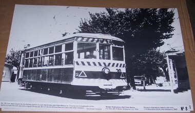
Photograph - Illustration/s, Windsor Publications, Bendigo Birney 30
Large print illustration of SEC Bendigo Birney No. 30 ex depot running out to the Railway station on a Sunday prior to running to Eaglehawk. No. 8 of a series of illustrations. Caption notes that Birney's no longer do this job - photo possible mid to late 1960's. Photo Windsor Publications. Two copies held. Printed on heavy cardboard with a gloss sheet.On rear of copy 1, letters "TBT"trams, tramways, birney, bendigo, windsor publications -
 Ballarat Tramway Museum
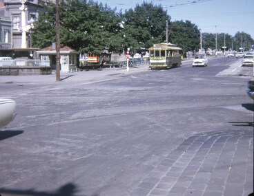
Slide - 27 mm sq slide/s - set of 2, Andrew Howlett, tram 30 at the City terminus, Nov. 1969
Yields information about the intersection of Lydiard St and Sturt St.Colour slide, Kodak white cardboard mount, developed Nov 1969 of No. 30 at the City terminus and then crossing Lydiard St on its way to Victoria St. In the background on .1 is the Santa Tram, No. 18. As well the shelter at the City tram terminus, the National Mutual building, the Town Hall, Georges Sea Food bar and V. F Gemmola Chemist.ballarat, tramways, trams, sturt st, lydiard st, town hall, tram 30 -
 Eltham District Historical Society Inc
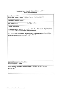
Document - Series Listing, Fraser Faithfull et al, Series 65: Russell Yeoman's 30 Years Service Function, negatives, 2000
13 colour negatives taken on the occasion of Mr Russell Yeoman's 30 years service celebrations. Mr Yeoman worked in Shire Planning. Also on same film (included in this Series) are 12 colour negatives of rural Shire scenes, including a road running through bushland.shire of eltham archives, series listing -
 Port Melbourne Historical & Preservation Society
Audio - Victorians in the Boer War, Rob Droogleever, 23 Jul 2012
Rob Droogleever discussing Victorians in the Boer War 1899-1902.Duration 01:29:30armed services, war - boer war, rob droogleever -
 Melbourne Athenaeum Archives
Theatre Flyer, Dami Im ‘Yesterday Once More’ 2016 National Tour performed at Melbourne Athenaeum Theatre on 19 November 2016, 2016
Eurovision rep 2016 placed secomcoloured flyer dami im, athenaeum theatre, yesterday once more tour -
Melbourne Athenaeum Archives
Internet Article, The Show of the Year 2016 Presemted by the Wheeeler Centre commencing at the Athenaeum Theatre 7th of december 2016, 2016
internet promo article Printout double - sidedcasey benneto, deborah conway, wheelers centre -
 Galen Catholic College
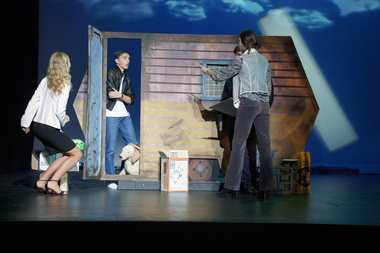
Legally Blonde - The Musical Whole School Production, 2016
Galen Catholic College has usually put on at least one theatrical production every year and in 2016, Legally Blonde - The Musical was the whole school production. These photos show the performers during the production, as well as the musicians.galen catholic college, galen college, school theatrical productions, legally blonde, 2016, musical -
 Old Colonists' Association of Ballarat Inc.
Photograph - Image, Clare Gervasoni, Ballarat Old Colonists' Association Residence - Permewan Cottage, 2016, 2016
This cottage was completed in 1956. One of the first objectives of the Association was "to provide the shelter of a hose for those Pioneers of the Goldfields whom the reverses of fortune have deprived of the means of procuring the comforts of life in their declining years." The first home at Charles Anderson Grove was built in 1925. Before that time the Association provided relief for needy pioneers. relief included monthly monetary payments, loads of firewood, medical assistance and distribution of Christmas bosed of groceries to deserving pensioners, and in some cases payment of burial costs. ::a) The dominant purpose of the Association is to give public benevolent relief as a charity, but providing independent living accommodation in our Retirement Village for person in need who are over 65. ::b) To raise funds by membership subscription, commercial and residential rents, donations, gifts and voluntary work, for the purpose of providing direct relief of poverty, distress, misfortune or helplessness. ::c) To maintain the important heritage and ongoing viability of the Old Colonists' Association. (Revised Rules of the Old Colonists' Association of Ballarat Inc., 2016) Colour photograph of Permewan Cottage at The Old Colonists' Assiation of Ballarat Inc retirement village at Charles Anderson Grove, Ballarat.old colonists' association, ballarat, ballarat old colonists' club, charles anderson grove, permewan, permewan cottage, retirement village -
 Greensborough Historical Society
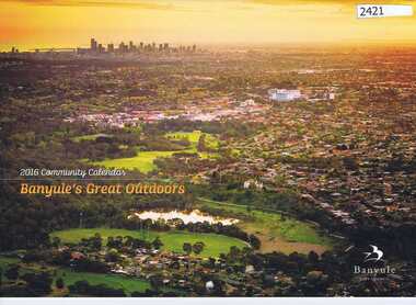
Calendar, Banyule City Council, Banyule Community Calendar 2016: Banyule's great outdoors, 2016_
This community calendar is distributed to residents of the City of Banyule each year. Each year it focusses on an aspect of the local community. The 2016 calendar contains photographs of local scenes and activities. Some council services are detailed in the back pages.The annual report is a record of the activities and services in the Banyule City Council area.28 pages. Colour illustrations. Illustrations of local scenes and landmarks.banyule city council, banyule community calendar -
 Melbourne Tram Museum
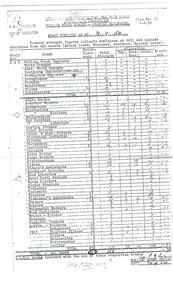
Document - Photocopy, Yarra Trams, "Rolling Stock Branch - Preston Workshops Staff Position as at 30-4-54", undated
Photocopy on A3 paper of a MMTB report titled "Rolling Stock Branch - Preston Workshops Staff Position as at 30-4-54". Showing the staff both officers and tradesmen, apprentices, establishment numbers and actual numbers of employees at Preston Workshops. Establishment was 683, actual number 613. Signed by the Rolling stock Engineer - report to the Chief Engineer. Not known when copy made.trams, tramways, mmtb, preston workshops, personnel -
National Vietnam Veterans Museum (NVVM)
Certificate, Victorian Branch VVAA Statewide Gravesite Commemorations, Sunday 21 February, 2016, Certificate of Appreciation awarded to Eric Cross
Awarded to Eric Cross for your significant contribution to the success & dignity of the Commemorations by playing the Last Post & Rouse. as above 2016 Good G Wade 2019 7/03/2019 Collected 11/07/1905 Library G Wade Victorian Branch VVAA 7/03/2019 7425 Document Documents: Folder 3 The Battle of Long Tan: Vietnamese Accounts Reviewed - What did they say?"Battle of Long Tannational vietnam veterans museum -
 Galen Catholic College
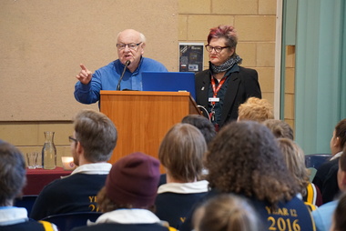
Father Bob Maguire visits Galen Catholic College, 2016
Father Bob spoke to our Year 12 students in 2016 in our auditorium. Father Bob Maguire is a well known priest, community worker and media personality from South Melbourne. These photographs are a record of Father Bob's presentation. galen catholic college, galen college, vce, year 12, year 12 students, auditorium -
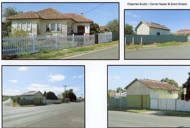 Stawell Historical Society Inc
Photograph, Mr W. J. Chapman -- Stawell Photographer's home on the corner of Maud and Grant Streets 2016
Home of W. J. Chapman Photographer of Stawell corner of Maud and Grant Streets. 8 Maud Street which later was renumbered 29 Grant Street. Photographic Studio back onto Grant Street. Photos Taken 2016.stawell business -
 Melbourne Tram Museum
Document - Memorandum, Melbourne & Metropolitan Tramways Board (MMTB), "Parade of Boy Scouts and Cadets, Through City Streets, Friday 24 May 1946 - 1:30 to 2:20pm Approximately", 11/04/1946 12:00:00 AM
Parade of Boy Scouts and Cadets, Through City Streets, Friday 24 May 1946 - 1:30 to 2:20pm Approximately Letter from HS Wooton, Melbourne Town Clerk to the Secretary MMTB advising of Empire Day Movement procession through the city on 24 May 1946. Letter dated 11 April 1946. Memo from Assistant Manger to Officers Concerned. Memorandum - several typed sheets (8"x10.5") - titled "Parade of Boy Scouts and Cadets, Through City Streets, Friday 24 May 1946 - 1:30 to 2:20pm Approximately" from JM Harry, District Traffic Superintendent S.S. to Mr Mazoletti, Malvern Depot, Mr McLean, Hanna Street Depot, and Mr Cliff, Glenhuntly Depot. Memo dated 21 May October and specifies tram shunting and special trams for the procession."Empire Day Movement Procession Fri 24/5/46" written in red pencil on the letter. Date, assembly point and procession route underlined in red pencil. "13 mts to pass ? & City Rds 1.30 to 1.43" initials and date written in black ink. "5 copies" and "23rd" "1947" written in black pencil on Malvern memo "4 copies" and "23rd" "1947" written in black pencil on Hanna Street memo "5 copies" and "23rd" "1947" written in black pencil on Glenhuntly memotrams, tramways, letters, instructions, events -
![Newspaper Clipping, Pride of the nation. Australia Day honours [2016], 27/01/2016](/media/collectors/4f729f5697f83e03086015b8/items/57d27d8bd0cdd11f0cf295ab/item-media/57d27f47d0cdd11f0cf39dfe/item-fit-380x285.jpg) Greensborough Historical Society
Greensborough Historical SocietyNewspaper Clipping, Pride of the nation. Australia Day honours [2016], 27/01/2016
Retired Melbourne Fire Brigade Superintendent John Berry from Lower Plenty, received a Medal of the Order of Australia for his work. Nillumbik Council Australia Day Citizen of the Year was awarded to Eltham local Beth Pender for contributions to the community and various causes.News clipping, black text, colour image.australia day awards, john berry, beth pender