Showing 602 items
matching attractions
-
 Bendigo Historical Society Inc.
Document - Legend to maps A, B and C for Lake Eppalock
John Perry Collection. Laminated 'legend' for Maps A, B and C for Lake Eppalock also in this collection. Black and White definitions and descriptions of objects and markers found on maps. Circa 1951. The dam was built by the State Rivers and Water Supply Commission of Victoria. The dam wall height is 45 metres (148 ft) and the main embankment is 1,041 metres (3,415 ft) long. At 100% capacity the dam wall was designed to hold back 304,651 megalitres (6.7014×10¹⁰ imp gal; 8.0480×10¹⁰ US gal) of water. The surface area of Lake Eppalock is 3,011 hectares (7,440 acres) and the catchment area is 2,124 square kilometres (820 sq mi). The controlled spillway is capable of discharging 8,040 cubic metres per second (284,000 cu ft/s). Lake Eppalock supplies both stock and domestic water to the Campaspe irrigation district. It also serves as a water supply to Bendigo and Heathcote and, in more recent times, Ballarat. The lake is a major attraction for those engaging in watersports, with a number of tourist parks and accommodation facilities available. Permissible activities on the lake include high-speed boating, water skiing, sailing, canoeing, fishing and swimming. The lake's water levels were low for approximately eight years between 2002 and 2010 during a prolonged drought, which restricted the amount of recreational activity until rainfall in the latter half of 2010 returned the lake to 100 percent capacity. Built between 1961 and 1964, Lake Eppalock remains the only water storage on the Campaspe River system.map, water, dam, reservoir, eppalock -
Bendigo Historical Society Inc.
Map - Map of overlay of lake Eppalock at full capacity. Map 'C'
John Perry collection. Map 'C'. Laminated map of overlay of Lake Eppalock at full capacity. Circa 1951. The dam was built by the State Rivers and Water Supply Commission of Victoria. The dam wall height is 45 metres (148 ft) and the main embankment is 1,041 metres (3,415 ft) long. At 100% capacity the dam wall was designed to hold back 304,651 megalitres (6.7014×10¹⁰ imp gal; 8.0480×10¹⁰ US gal) of water. The surface area of Lake Eppalock is 3,011 hectares (7,440 acres) and the catchment area is 2,124 square kilometres (820 sq mi). The controlled spillway is capable of discharging 8,040 cubic metres per second (284,000 cu ft/s). Lake Eppalock supplies both stock and domestic water to the Campaspe irrigation district. It also serves as a water supply to Bendigo and Heathcote and, in more recent times, Ballarat. The lake is a major attraction for those engaging in watersports, with a number of tourist parks and accommodation facilities available. Permissible activities on the lake include high-speed boating, water skiing, sailing, canoeing, fishing and swimming. The lake's water levels were low for approximately eight years between 2002 and 2010 during a prolonged drought, which restricted the amount of recreational activity until rainfall in the latter half of 2010 returned the lake to 100 percent capacity. Built between 1961 and 1964, Lake Eppalock remains the only water storage on the Campaspe River system.map, water, eppalock, dam, reservoir -
Bendigo Historical Society Inc.
Map - Laminated map of Lake Eppalock empty. Map 'D'
John Perry Collection. Laminated map of Lake Eppalock empty. Map 'D'. Circa 1951. The dam was built by the State Rivers and Water Supply Commission of Victoria. The dam wall height is 45 metres (148 ft) and the main embankment is 1,041 metres (3,415 ft) long. At 100% capacity the dam wall was designed to hold back 304,651 megalitres (6.7014×10¹⁰ imp gal; 8.0480×10¹⁰ US gal) of water. The surface area of Lake Eppalock is 3,011 hectares (7,440 acres) and the catchment area is 2,124 square kilometres (820 sq mi). The controlled spillway is capable of discharging 8,040 cubic metres per second (284,000 cu ft/s). Lake Eppalock supplies both stock and domestic water to the Campaspe irrigation district. It also serves as a water supply to Bendigo and Heathcote and, in more recent times, Ballarat. The lake is a major attraction for those engaging in watersports, with a number of tourist parks and accommodation facilities available. Permissible activities on the lake include high-speed boating, water skiing, sailing, canoeing, fishing and swimming. The lake's water levels were low for approximately eight years between 2002 and 2010 during a prolonged drought, which restricted the amount of recreational activity until rainfall in the latter half of 2010 returned the lake to 100 percent capacity. Built between 1961 and 1964, Lake Eppalock remains the only water storage on the Campaspe River system.map, water, dam, reservoir, eppalock -
Bendigo Historical Society Inc.
Document - Collection of photographs from newspaper on a single page
John Perry Collection. Laminated copy of page from 'Weekly Times' newspaper, February, 1962. Nine images relating to establishing and building Eppalock Reservoir, 15 miles from Bendigo. The dam was built by the State Rivers and Water Supply Commission of Victoria. The dam wall height is 45 metres (148 ft) and the main embankment is 1,041 metres (3,415 ft) long. At 100% capacity the dam wall was designed to hold back 304,651 megalitres (6.7014×10¹⁰ imp gal; 8.0480×10¹⁰ US gal) of water. The surface area of Lake Eppalock is 3,011 hectares (7,440 acres) and the catchment area is 2,124 square kilometres (820 sq mi). The controlled spillway is capable of discharging 8,040 cubic metres per second (284,000 cu ft/s). Lake Eppalock supplies both stock and domestic water to the Campaspe irrigation district. It also serves as a water supply to Bendigo and Heathcote and, in more recent times, Ballarat. The lake is a major attraction for those engaging in watersports, with a number of tourist parks and accommodation facilities available. Permissible activities on the lake include high-speed boating, water skiing, sailing, canoeing, fishing and swimming. The lake's water levels were low for approximately eight years between 2002 and 2010 during a prolonged drought, which restricted the amount of recreational activity until rainfall in the latter half of 2010 returned the lake to 100 percent capacity. Built between 1961 and 1964, Lake Eppalock remains the only water storage on the Campaspe River system. dam, engineering, water, eppalock -
Bendigo Historical Society Inc.
Map - Laminated map of Lake Eppalock at full capacity
John Perry Collection. Laminated copy of map of Lake Eppalock at full capacity. Had highlighter markings of old roads which appear to be still in use. The dam was built by the State Rivers and Water Supply Commission of Victoria. The dam wall height is 45 metres (148 ft) and the main embankment is 1,041 metres (3,415 ft) long. At 100% capacity the dam wall was designed to hold back 304,651 megalitres (6.7014×10¹⁰ imp gal; 8.0480×10¹⁰ US gal) of water. The surface area of Lake Eppalock is 3,011 hectares (7,440 acres) and the catchment area is 2,124 square kilometres (820 sq mi). The controlled spillway is capable of discharging 8,040 cubic metres per second (284,000 cu ft/s). Lake Eppalock supplies both stock and domestic water to the Campaspe irrigation district. It also serves as a water supply to Bendigo and Heathcote and, in more recent times, Ballarat. The lake is a major attraction for those engaging in watersports, with a number of tourist parks and accommodation facilities available. Permissible activities on the lake include high-speed boating, water skiing, sailing, canoeing, fishing and swimming. The lake's water levels were low for approximately eight years between 2002 and 2010 during a prolonged drought, which restricted the amount of recreational activity until rainfall in the latter half of 2010 returned the lake to 100 percent capacity. Built between 1961 and 1964, Lake Eppalock remains the only water storage on the Campaspe River system.map, water, dam, reservoir, eppalock -
Bendigo Historical Society Inc.
Map - Black and White map. Outline of Lake Eppalock. Map 'B'
John Perry Collection. Laminated copy black and white map. Map 'B'. Outline of Lake Eppalcok, overlayed on map. Circa 1951. The dam was built by the State Rivers and Water Supply Commission of Victoria. The dam wall height is 45 metres (148 ft) and the main embankment is 1,041 metres (3,415 ft) long. At 100% capacity the dam wall was designed to hold back 304,651 megalitres (6.7014×10¹⁰ imp gal; 8.0480×10¹⁰ US gal) of water. The surface area of Lake Eppalock is 3,011 hectares (7,440 acres) and the catchment area is 2,124 square kilometres (820 sq mi). The controlled spillway is capable of discharging 8,040 cubic metres per second (284,000 cu ft/s). Lake Eppalock supplies both stock and domestic water to the Campaspe irrigation district. It also serves as a water supply to Bendigo and Heathcote and, in more recent times, Ballarat. The lake is a major attraction for those engaging in watersports, with a number of tourist parks and accommodation facilities available. Permissible activities on the lake include high-speed boating, water skiing, sailing, canoeing, fishing and swimming. The lake's water levels were low for approximately eight years between 2002 and 2010 during a prolonged drought, which restricted the amount of recreational activity until rainfall in the latter half of 2010 returned the lake to 100 percent capacity. Built between 1961 and 1964, Lake Eppalock remains the only water storage on the Campaspe River system.map, water, dam, reservoir, eppalock -
Bendigo Historical Society Inc.
Map - General view of area of proposed construction of Lake Eppalock. Map 'A'
John Perry Collection. Laminated map of proposed construction of Lake Eppalock. Map 'A'. Black and white map in laminate. Circa 1951. The dam was built by the State Rivers and Water Supply Commission of Victoria. The dam wall height is 45 metres (148 ft) and the main embankment is 1,041 metres (3,415 ft) long. At 100% capacity the dam wall was designed to hold back 304,651 megalitres (6.7014×10¹⁰ imp gal; 8.0480×10¹⁰ US gal) of water. The surface area of Lake Eppalock is 3,011 hectares (7,440 acres) and the catchment area is 2,124 square kilometres (820 sq mi). The controlled spillway is capable of discharging 8,040 cubic metres per second (284,000 cu ft/s). Lake Eppalock supplies both stock and domestic water to the Campaspe irrigation district. It also serves as a water supply to Bendigo and Heathcote and, in more recent times, Ballarat. The lake is a major attraction for those engaging in watersports, with a number of tourist parks and accommodation facilities available. Permissible activities on the lake include high-speed boating, water skiing, sailing, canoeing, fishing and swimming. The lake's water levels were low for approximately eight years between 2002 and 2010 during a prolonged drought, which restricted the amount of recreational activity until rainfall in the latter half of 2010 returned the lake to 100 percent capacity. Built between 1961 and 1964, Lake Eppalock remains the only water storage on the Campaspe River system.map, dam, water, weir, eppalock -
Bendigo Historical Society Inc.
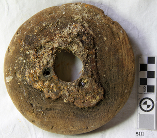
Map - Laminated worksheet - identification of inundated artifacts at Lake Eppalock
John Perry Collection. Laminated copy of worksheet identifying inundated artifacts at Lake Eppalock when at 10% capacity. The dam was built by the State Rivers and Water Supply Commission of Victoria. The dam wall height is 45 metres (148 ft) and the main embankment is 1,041 metres (3,415 ft) long. At 100% capacity the dam wall was designed to hold back 304,651 megalitres (6.7014×10¹⁰ imp gal; 8.0480×10¹⁰ US gal) of water. The surface area of Lake Eppalock is 3,011 hectares (7,440 acres) and the catchment area is 2,124 square kilometres (820 sq mi). The controlled spillway is capable of discharging 8,040 cubic metres per second (284,000 cu ft/s). Lake Eppalock supplies both stock and domestic water to the Campaspe irrigation district. It also serves as a water supply to Bendigo and Heathcote and, in more recent times, Ballarat. The lake is a major attraction for those engaging in watersports, with a number of tourist parks and accommodation facilities available. Permissible activities on the lake include high-speed boating, water skiing, sailing, canoeing, fishing and swimming. The lake's water levels were low for approximately eight years between 2002 and 2010 during a prolonged drought, which restricted the amount of recreational activity until rainfall in the latter half of 2010 returned the lake to 100 percent capacity. Built between 1961 and 1964, Lake Eppalock remains the only water storage on the Campaspe River system.map, artifacts, eppalock, reservoir -
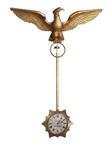 The Beechworth Burke Museum
Decorative object - Swinging Clock, Charles Frederick Falck, 1855
This clock was made by Charles Frederick Falck who was a watchmaker and jeweller in Beechworth from 1863-1908. Falck was born in Körlin, Prussia on May 22nd in 1833 and died at the age of 75 in 1908. Ovens and Murray Advertiser, Beechworth: edition June 13, 1908 OBITUARY: Falck was brought up to the business of watch-making, in which he developed exceptional mechanical ingenuity. Attracted by the favourable prospects held out by the Australian discoveries of gold he, like many other young adventurous spirits, left his native land to seek his fortune in the great southern Eldorado, arriving in Adelaide in 1854, and shortly after came to Melbourne where he worked as a journeyman, and subsequently started in business on his own account. Feeling inclined to test his fortune on the goldfields, he went to Blackwood but, meeting with little success, he returned to Melbourne where he was married. In 1862, he moved to Beechworth, where he commenced business as watchmaker and gold-buyer. He then embarked in vine-growing on the Sydney road, but eventually resumed his business avocations. His skill in practical horology was evinced in a clock of his own design and manufacture, surmounted by a golden eagle, which was exhibited at the first Melbourne Exhibition in 1856, and which afterwards formed a pre-eminent attraction in the window of his business premises in Ford Street. For many years, he filled the position of timekeeper to the Beechworth Racing Club, with complete satisfaction also at various sports meetings. He leaves a family of six sons and one daughter (Mrs. Jas. Broadfoot) all arrived at maturity. The funeral, which was well attended by a number of residents, took place at the Beechworth Cemetery on Sunday, the burial service being performed by the Ven. Archdeacon Potter. The cortege was capably supervised by Mr. D. Wilson, undertaker. The clock was returned to Beechworth in 2020 through the generous support of the Copland Foundation. Given that Mr. C. F. Falck traded as a watchmaker and jeweller in Beechworth for 45 years and traded with the 1855 clock mounted in his front window, there is a direct link between the clocks and the social, cultural and economic life of nineteenth century Beechworth at time when the town was developing and expanding in response to gold mining. This clock represent the significant skill and expertise of Charles Falck as an horologist. Medium-sized pendulum clock featuring a carved gilt wood eagle with wings outstretch (épandre - expanded with wing-tips directed upwards) and perched above a pendulum rod that holds a silver dial clock face within a reeded sunburst surround. The clock has an eight-day fuse movement with dead beat escapement wound from the clock face. C. F. F. FALCK / EXHIBITION 1856 / MELBOURNEburke museum, copland foundation, beechworth, leonard joel, auction, purchase, clock, pendulum, eagle, eagle clock, charles frederick falck, c. f. falck, falck, horology, pendulum clock, melbourne -
 The Beechworth Burke Museum
Decorative object - Swinging Clock, Charles Frederick Falck, 1870
This clock was made by Charles Frederick Falck who was a watchmaker and jeweller in Beechworth from 1863-1908. Falck was born in Körlin, Prussia on May 22nd in 1833 and died at the age of 75 in 1908. Ovens and Murray Advertiser, Beechworth: edition June 13, 1908 OBITUARY: Falck was brought up to the business of watch-making, in which he developed exceptional mechanical ingenuity. Attracted by the favourable prospects held out by the Australian discoveries of gold he, like many other young adventurous spirits, left his native land to seek his fortune in the great southern Eldorado, arriving in Adelaide in 1854, and shortly after came to Melbourne where he worked as a journeyman, and subsequently started in business on his own account. Feeling inclined to test his fortune on the goldfields, he went to Blackwood but, meeting with little success, he returned to Melbourne where he was married. In 1862, he moved to Beechworth, where he commenced business as watchmaker and gold-buyer. He then embarked in vine-growing on the Sydney road, but eventually resumed his business avocations. His skill in practical horology was evinced in a clock of his own design and manufacture, surmounted by a golden eagle, which was exhibited at the first Melbourne Exhibition in 1856, and which afterwards formed a pre-eminent attraction in the window of his business premises in Ford Street. For many years, he filled the position of timekeeper to the Beechworth Racing Club, with complete satisfaction also at various sports meetings. He leaves a family of six sons and one daughter (Mrs. Jas. Broadfoot) all arrived at maturity. The funeral, which was well attended by a number of residents, took place at the Beechworth Cemetery on Sunday, the burial service being performed by the Ven. Archdeacon Potter. The cortege was capably supervised by Mr. D. Wilson, undertaker. The clock was returned to Beechworth in 2020 through the generous support of the Copland Foundation and the Friends of the Burke. Given that Mr. C. F. Falck traded as a watchmaker and jeweller in Beechworth for 45 years and traded with the 1855 clock mounted in his front window, there is a direct link between the clocks and the social, cultural and economic life of nineteenth century Beechworth at time when the town was developing and expanding in response to gold mining. This clock represent the significant skill and expertise of Charles Falck as an horologist. Large swinging clock featuring a carved gilt wood eagle with its wings outstretched (abaisé - expanded with wing-tips lowered) and perched above a pendulum rod that holds a silvered dial clock face within a reeded sunburst surround. (Similar to #2019.056.01) The clock has an eight-day fuse movement with dead beat escapement wound from the clock face. C. F. FALCK / WATCHMAKERburke museum, copland foundation, beechworth, leonard joel, auction, purchase, clock, pendulum, eagle, eagle clock, charles frederick falck, c. f. falck, falck, horology, pendulum clock, melbourne -
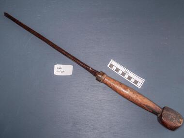 City of Moorabbin Historical Society (Operating the Box Cottage Museum)
Tools, Screwdriver large, c1900
A screwdriver is a tool, manual or powered, for turning (driving or removing) screws. A typical simple screwdriver has a handle and a shaft, and a tip that the user inserts into the screw head to turn it. The shaft is usually made of tough steel to resist bending or twisting. The tip may be hardened to resist wear, treated with a dark tip coating for improved visual contrast between tip and screw—or ridged or treated for additional 'grip'. Handle are typically wood, metal, or plastic and usually hexagonal, square, or oval in cross-section to improve grip and prevent the tool from rolling when set down. The handle and shaft of screwdrivers have changed considerably over time. The "Perfect Pattern Handle’ screwdriver was first manufactured by HD Smith & Company, which operated from 1850 to 1900. Screwdrivers were probably invented in the late 15th century, either in Germany or France when Screws were used to construct screw-cutting lathes, for securing breastplates, backplates, and helmets on medieval jousting armor—and eventually for multiple parts of the emerging firearms, particularly the matchlock. The jaws that hold the pyrites inside medieval guns were secured with screws, and the need to constantly replace the pyrites resulted in considerable refinement of the screwdriver. The screwdriver depended entirely on the screw, and it took several advances to make the screw easy enough to produce to become popular and widespread Canadian P.L. Robertson, though he was not the first person to patent the idea of socket-head screws, was the first to successfully commercialize them, starting in 1908. In Portland, Oregon, Henry F. Phillips patented his own invention, an improved version of a deep socket with a cruciform slot, today known as the Phillips Screw. Phillips offered his screw to the American Screw Company, and after a successful trial on the 1936 Cadillac, it quickly swept through the American auto industry. A main attraction for the screw was that conventional slotted screwdrivers could also be used on them, which was not possible with the Robertson Screw. A large steel screwdriver with worn wooden handlepioneers, early settlers, market gardeners, moorabbin, bentleigh, cheltenham, brighton, tools, craftsman, carpenters, , blacksmiths, builders, farmers, metalwork, woodwork, screws, philllips head screwdrivers, h.d.smith & co usa, p.l. robertson, henry f.phillips , oregon, canada, american screw company, -
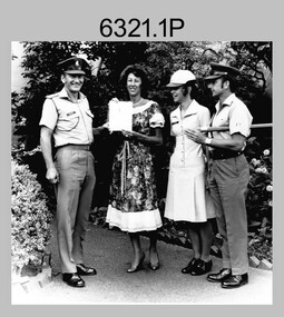 Bendigo Military Museum
Photograph - Army Survey Regiment – Presentation to Charity Organisation, 1984
These photographs of a presentation to a charity organisation were taken in the grounds of Fortuna Villa, Army Survey Regiment in 1984. SPR Tracy (Parker) Ash was the unit’s Miss Golden North section entrant in the Miss Australia Quest. MAJ Bob Roche, RSM Bob Mason and SPR Parker presented a fundraising cheque to the unidentified representative from the Spastic Society. The the newspaper article is from the Bendigo Advertiser. The following wording is taken from the article: ‘Tracy Parker is a sapper in the Army, and a cartographic technician stationed at Fortuna, Bendigo. Originally from Melbourne, Tracy, 23, is the latest entrant in the Miss Golden North segment of the Miss Australia Quest. The highlight of Tracy’s quest will be an open day at Fortuna, once the magnificent home of Bendigo’s Quartz King, George Lansell. This open day at Fortuna, on Sunday, August 26, between 10 am and 4 pm, will give district residents a rare opportunity of inspecting this magnificent building and its gardens. Tracy said there will be handicrafts, rides, competitions and refreshments available at the open day. The main attraction, apart from the building and gardens, would be a hot air balloon. Admission to the open day would be: Adults $2, children and pensioners $1, family party $5. All proceeds from the open day at Fortuna will go to the Spastic Society. Tracy, like all other Miss Australia candidates work hard for the Spastic Society in fundraising activities. Getting further involved in fundraising, Tracy and her strong committee have organised a 6km fun run for Sunday August 19. Entry forms are available at Bendigo sports stores, and at the end of the fun run will be a barbecue. Apart from her vocation in the Army, and fundraising for the Spastic Society, Tracy Parker has a great love of horses, and associated activities of riding, jumping and showing her horses. Tracy is keen to do well in her fundraising, and with the Australian Army, or more particularly, the ranks of Fortuna behind her, Tracy looks like succeeding.’The first three items are photographs of a presentation to a charity organisation at the Army Survey Regiment, Bendigo in 1984. The fourth item is an article from the Bendigo Advertiser describing Army Survey Regiment’s fund-raising activities. The photographs were printed on photographic paper and are part of the Army Survey Regiment’s Collection. The photographic proof prints were scanned at 600 dpi. Photos .1P and .2P were scanned at 300 dpi. The newspaper article was scanned at 762 dpi. .1) to .3P) - Photo, black & white, 1984, L to R: MAJ Bob Roche, Regional Coordinator Mrs Jan Lamborn, SPR Tracy (Parker) Ash, RSM WO1 Bob Mason. .4) – Bendigo Advertiser newspaper article with photo, black & white, 1984, SPR Tracy (Parker) Ash. .1P to .2P – ‘Presentation of Certificate of Appreciation from Spastic Society. Presented by Regional Coordinator Mrs Jan Lamborn to MAJ Roche, SPR Tracy Ash (entrant in Miss Australia Quest (1984) and WO1 Mason.' .3P – No personnel identified. .4P – SPR Tracy Parker named in newspaper article.royal australian survey corps, rasvy, army survey regiment, army svy regt, fortuna, asr -
 Bendigo Historical Society Inc.
Newspaper - NEWSPAPER COLLECTION: BENDIGO ADVERTISER VARIOUS ARTICLES
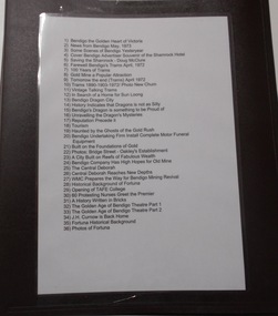
1) Bendigo the Golden Heart of Victoria 2) News from Bendigo May, 1973 3) Some Scenes of Bendigo Yesteryear 4) Cover Bendigo Advertiser Souvenir of the Shamrock Hotel 5) Saving the Shamrock - Doug McClure 6) Farewell Bendigo's Trams April, 1972 7) 100 Years of Trams 8) Gold Mine a Popular Attraction 9) Tomorrow the end (Trams) April 1972 10) Trams 1890-1903-1972/ Photo New Chum 11) Vintage Talking Trams 12) In Search of a Home for Sun Loong 13) Bendigo Dragon City 14) History Indicates that Dragons is not as Silly 15) Bendigo's Dragon is Something to be Proud of 16) Unravelling the Dragon's Mysteries 17) Reputation Precede it 18) Tourism 19) Haunted by the Ghosts of the Gold Rush 20) Bendigo Undertaking Firm Installs Complete Motor Funeral Equipment 21) Built on the Foundations of Gold 22) Photos: Bridge Street - Oakley's Establishment 23) A City Built on reefs of Fabulous Wealth 24) Bendigo Company Has High Hopes for Old Mine 25) The Central Deborah 26) Central Deborah Reaches New Depths 27) WMC Prepares the Way for Bendigo Mining Revival 28) Historical Background of Fortuna 29) Opening of TAFE College 30) 60 Protesting Nurses Greet the Premier 31) A History Written in Bricks 32) The Golden Age of Bendigo Theatre Part 1 33) The Golden Age of Bendigo Theatre Part 2 34) J.H. Curnow is Back Home 35) Fortuna Historical Background 36) Photos of Fortuna. Folder 110 now in Box 417. AV 03/11/2022bendigo, goldfields, tourism, history -
Bendigo Historical Society Inc.
Document - Directions to Lake Eppalock with road descriptions and map
John Perry Collection. Laminated copy of 'Directions to Lake Eppalock'. Gives directions in relationship of Lake Eppalock to Bendigo, Kyneton and Heathcote. Undated. Gives basic descriptions of bridges on lakebed, ford crossings on lakebed and inundated dwellings on lakebed. The dam was built by the State Rivers and Water Supply Commission of Victoria. The dam wall height is 45 metres (148 ft) and the main embankment is 1,041 metres (3,415 ft) long. At 100% capacity the dam wall was designed to hold back 304,651 megalitres (6.7014×10¹⁰ imp gal; 8.0480×10¹⁰ US gal) of water. The surface area of Lake Eppalock is 3,011 hectares (7,440 acres) and the catchment area is 2,124 square kilometres (820 sq mi). The controlled spillway is capable of discharging 8,040 cubic metres per second (284,000 cu ft/s). Lake Eppalock supplies both stock and domestic water to the Campaspe irrigation district. It also serves as a water supply to Bendigo and Heathcote and, in more recent times, Ballarat. The lake is a major attraction for those engaging in watersports, with a number of tourist parks and accommodation facilities available. Permissible activities on the lake include high-speed boating, water skiing, sailing, canoeing, fishing and swimming. The lake's water levels were low for approximately eight years between 2002 and 2010 during a prolonged drought, which restricted the amount of recreational activity until rainfall in the latter half of 2010 returned the lake to 100 percent capacity. Built between 1961 and 1964, Lake Eppalock remains the only water storage on the Campaspe River system.water, dam, directions, eppalock -
Bendigo Historical Society Inc.
Map - Map of Lake Eppalock shoreline when empty
John Perry Collection. Laminated copy of map detailing Lake Eppalock shoreline when empty. Circa 1951. Has colored highlighter lines following roads leading to lake shoreline and various inundated old roads and tracks on lakebed. The dam was built by the State Rivers and Water Supply Commission of Victoria. The dam wall height is 45 metres (148 ft) and the main embankment is 1,041 metres (3,415 ft) long. At 100% capacity the dam wall was designed to hold back 304,651 megalitres (6.7014×10¹⁰ imp gal; 8.0480×10¹⁰ US gal) of water. The surface area of Lake Eppalock is 3,011 hectares (7,440 acres) and the catchment area is 2,124 square kilometres (820 sq mi). The controlled spillway is capable of discharging 8,040 cubic metres per second (284,000 cu ft/s). Lake Eppalock supplies both stock and domestic water to the Campaspe irrigation district. It also serves as a water supply to Bendigo and Heathcote and, in more recent times, Ballarat. The lake is a major attraction for those engaging in watersports, with a number of tourist parks and accommodation facilities available. Permissible activities on the lake include high-speed boating, water skiing, sailing, canoeing, fishing and swimming. The lake's water levels were low for approximately eight years between 2002 and 2010 during a prolonged drought, which restricted the amount of recreational activity until rainfall in the latter half of 2010 returned the lake to 100 percent capacity. Built between 1961 and 1964, Lake Eppalock remains the only water storage on the Campaspe River system.map, eppalock, reservoir, lake, water -
Bendigo Historical Society Inc.
Document - Black and white laminated photo of flow of water from Lake Eppalock. 1964
John Perry Collection. Laminated copy of photo of crowd watching flow of water from the opened valve at the wall of Lake Eppalock during its commissioning. March, 1964. Lake Eppalock was created by flooding to town of Wild Duck. The dam was built by the State Rivers and Water Supply Commission of Victoria. The dam wall height is 45 metres (148 ft) and the main embankment is 1,041 metres (3,415 ft) long. At 100% capacity the dam wall was designed to hold back 304,651 megalitres (6.7014×10¹⁰ imp gal; 8.0480×10¹⁰ US gal) of water. The surface area of Lake Eppalock is 3,011 hectares (7,440 acres) and the catchment area is 2,124 square kilometres (820 sq mi). The controlled spillway is capable of discharging 8,040 cubic metres per second (284,000 cu ft/s). Lake Eppalock supplies both stock and domestic water to the Campaspe irrigation district. It also serves as a water supply to Bendigo and Heathcote and, in more recent times, Ballarat. The lake is a major attraction for those engaging in watersports, with a number of tourist parks and accommodation facilities available. Permissible activities on the lake include high-speed boating, water skiing, sailing, canoeing, fishing and swimming. The lake's water levels were low for approximately eight years between 2002 and 2010 during a prolonged drought, which restricted the amount of recreational activity until rainfall in the latter half of 2010 returned the lake to 100 percent capacity. Built between 1961 and 1964, Lake Eppalock remains the only water storage on the Campaspe River system.water, dam, reservoir, eppalock, wild duck -
 Federation University Historical Collection
Correspondence, Eureka Reserve Committee to City of Ballarat, 1956, 28/0281956
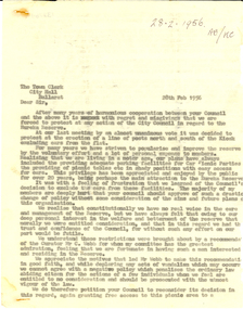
The Eureka Stockade Memorial Park Committee was a voluntary group that worked towards commemorating the Eureka Stockade by caring for the Reserve and organising events there. Three page carbon copy of a letter from the Eureka Stockade Memorial Park Committee to the City of Ballarat Town Clerk. The carbon copy is not signed. The letter was written because the Committee were not satisfied with the action of the Council in relation to the Eureka Reserve in relation to parking.The letter starts as follows: "The Town Clerk City Hall Ballarat Dear Sir, After many years of harmonious cooperation between your Council and the above it is with regret and misgivings that we are forced to protest at any action of the City Council in regard to the Eureka Reserve. At out last meeting by an almost unanimous vote it was decided to protest at the erection of a line of posts north and south of the Kiosk excluding cares from the flat. For many years we have striven to popularise and improve the reserve by the voluntary effort and a lot of personal expense by members. Realising that we are living in a motor age, our plans have always included the provifing of adequate parking facilities for car Picnic Partites the providing of picnic tables etc in shady positions with easy access for cars. This privilege has been appreciated and enjoyed by the public for over 20 years, being perhaps the main attraction to the Eureka Stockade. It was with a feeling of frustration that we learned of teh Council's decision to exclude the cars from these facilities. The majority of my member are deeply hurt that your council should approve of such drastic change of policy without some consideration of the aims and future plans of this organisation. ... "eureka, eureka stockade, eureka stockade memorial park, city of ballarat, ballarat -
 Flagstaff Hill Maritime Museum and Village
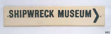
Sign - Shipwreck Museum sign, Flagstaff Hill Historic Park Planning Board, Shipwreck Museum, ca. 1975
This sign is painted on both sides. It was attached to the bluestone wall on the western wing of the Lighthouse Keeper's Quarters, the Assistant Keeper's Quarters, at Flagstaff Hill Maritime Museum and Village for almost 50 years. The Complex was opened to the public on December 11, 1975, and officially opened by Victorian Premier Sir Rupert Hamer on July 8th, 1977. The sign's reverse side reads "Loch Ard Peacock & Museum". The three rooms had displays behind glass showing various ships' fittings, cargo and personal belongings recovered from significant shipwrecks along the southwest coast of Victoria. There was also a display of information about the mysterious Mahogany Ship or Ancient Wreck. The shipwreck artefacts were recovered by local divers in the 1960s and early 1970s. Also on display was the famous Loch Ard Peacock, created in 1873, survived the shipwreck in 1878, was purchased by Flagstaff Hill in 1975 and announced as being on display in The Standard of September 15, 1975. In about 1984 the other side of the sign was painted "SHIPWRECK MUSEUM" and re-displayed on the building. The Loch Ard Peacock was by that time on display in the Entrance building; plans were underway on August 31st 1984 to build a Hall for its unique display. In February 2023 the sign was removed from the building, which was undergoing restoration and preparation for use as a new Temporary Exhibition space. The Loch Ard Peacock continued its journey around the Village; it was moved from the Entrance to the Village's newly completed Public Hal in 1986. It also spent a short time in the Stella Maris Tea Rooms. This was likely around 1998, when the Common School had moved from the Chartroom building to what had been the Public Hall. The Loch Ard Peacock was once again moved in around 2001, this time to be the central attraction and meeting place in the Great Circle Gallery, which opened on December 31st 2002. The sign continued to be displayed on the western wing of the Lighthouse Keeper's Quarters until February 2023. This wing has now been restored and re-fitted to become a facility for short-term exhibitions. A section of the original internal wall frame and wallpaper that couldn’t be kept in the building due to preservation issues have been saved and become sort of the Flagstaff Hill Collection. The sign has guided the visitors of Flagstaff Hill Maritime Museum and Village to the exhibits of artefacts from historic and significant shipwrecks. It has connected the current generations to the people and objects of the past, leading to a better understanding of our Colonial history.Sign, wooden, rectangular, with a hole through each short side. The front and reverse have different painted text. Cream paint for the background colour, green paint for the lettering, and the reverse has a white painted border. The front has an arrow painted on the right-hand side. The sign was used at Flagstaff Hill since its opening.Text on front "SHIPWRECK MUSEUM >" Text on back "LOCH ARD PEACOCK / & MUSEUM"flagstaff hill maritime museum and village, warrnambool, great ocean road, shipwreck coast, sign, building sign, shipwreck museum, loch ard peacock & museum, flagstaff hill history, assistant lighthouse keeper's cottage, assistand lighthouse keeper's quarters, public hall, common school -
Glen Eira Historical Society
Letter - CAULFIELD CENTENARY - 1957
This file contains seven items: 1/One double sided pamphlet regarding the Caulfield Centenary Carnival at Caulfield Park from 25/10/1957 to 05/11/1957, listing attractions and special events. Includes advertising for Bunny Industries on the back. 2/One pamphlet for the Children’s Carnival at Caulfield Racecourse on 29/10/1957 as part of the City of Caulfield Centenary celebrations. The pamphlet includes a timetable for the day’s events. 3/One six page pamphlet for a film festival organised by the Caulfield Film Society as part of the City of Caulfield Centenary Celebrations. The pamphlet includes a programme for each of the four days of the film festival, 14/10/1957, 17/10/1957, 23/10/1957 and 25/10/1957. The pamphlet also includes information about the Caulfield Film Society regarding their formation, their values, their manifesto and their officials. 4/An eight page programme for the centenary Thanksgiving Service on 13/10/1957 featuring prayers and hymns. 5/Two copies of a pamphlet regarding City of Caulfield Centenary Celebrations from 13/10/1957 to 05/11/1957 created by H.G. Nelson, Town Clerk. Events listed include Thanksgiving Service, Music Festival, Film Festival, Special Centenary Council Meeting, Gymkhana, Parade of Decorated Floats, Spring Flower Show, Massed Bands Display, Display of Art, Naturalisation Ceremony, Solemn High Mass, carnivals and plaque unveiling. 6/One original and one photocopy of an eight page notice paper for the Special Meeting of Caulfield City Council to commemorate the 100th Anniversary of the proclamation and declaration of the Caulfield Road District, to be held on 15/10/1957. The booklet includes the agenda, a council summons, a picture of Caulfield’s City Hall and a list of current and past councillors, chairmen, presidents, mayors and Shire Secretaries and town clerks. 7/A letter addressed to F. Campbell from Hazel Da Costa, dated 07/11/1997 regarding the acquisition of pamphletts for the Caulfield Centenary Carnival. For further information refer to the Oakleigh and Caulfield Times 09/10/1957 and Caulfield-Elsternwick Advertiser 05/11/1957 and 22/10/1957 stored in the Newspaper Archive room 4.caulfield centenary carnival, queen crowning ceremony, dandh bunny pty ltd, caulfield film society, carnegie memorial hall, caulfield park, hawthorn road, balaclava road, glenhuntly road, parades and processions, fire works displays, festivals and celebrations, bunny industries, glen press, hardware stores, builders suppliers, plumbers suppliers, centenary celebration, caulfield centenary, children’s carnival, caulfield racecourse, sinclair a.j.g., sporting events, film festival, new supper room, town hall, methodist hall, saint john hall, birch street, orrong road, princes park, caulfield hospital, daughters e.f., ward miss n., madigan mr. r, ritchie miss e., weichelt mr f., machin l.r., green w.c., jenner e.r., thomas w.r., centenary thanksgiving service, hymns, prayers, naturalisation ceremony, caulfield and district horses and pony club, special centenary council meeting, caulfield horticulture society, saint aloysius church, packer reserve, oakleigh road, caulfield memorial youth centre, commemoration, caulfield road district, mayors, presidents, chairmen, councillors, town clerks, parton e.m., bunny f.c.d., sims h.e., thomson w.r., wallace g.e., gunn e.e., gamble h.a., yorston j.s., handasyde g., murry ross w., stephen j.w., masters s., lloyd j.c., watts thos., watts t., nelson c., webb g.h., stephen f.j., crosbie j.w., watts w.c., holland j.c., lempriere w.g., millar w., newing t. r., ballantyne j., cotton a.d., long j., kirkham c.f., lloyd c.du p., wood f.g., akhurst a.c., riddell w.j.c., sharp t.c., phillips r.l., lempriere j.t., bayston w.s., dunbar a., hall p., saint j., fiske w., thompson h., murphy e.c., eggleston f.w., murray n.l., wood h.s., tyner w., wharington w.a., packer j.t., falls t., brooks w.r., lord r.h., morris a.e., page j.w., porter f.w., england e.f.s, patton r.t., mcculloch r., richie h.g., packer j.t., mackinnon d.c., mackinnon g.a., smith h.c.h., shillabeer f.e., pullman c.a., stewart l.mcr., tyers s.w., morris t.w., prior p.l., brooks w.r., webster h.c., sims h.e., prior p.l., thomson w.r., gunn e.e., parton e.m., wallace g.e., dempsey w., hart j., jowett f., briggs j.r., nelson h.g. -
 Monbulk Historical Society
Ben Simcox
Bennie Simcox first came to the Monbulk area about 1860, following the first important gold discovery at the end of 1858. As the gold rush was short lived Simcox returned to Collingwood but later came back to Monbulk, built himself a hut to live in and become its first known permanent resident. The hut was burnt in the 1913 fires. Monbulk was thrown open to selection in 1894, and that's when the first farmers including Bennie Simcox went into Monbulk. It was a big, timbered country in those days. Once Ben had cleared some of his land he started to grow raspberries on it. He would be up before daylight ready to start picking. Ben also picked for a local family, the Camms to help make ends meet. When Ben Simcox was virtually at the retired stage, he wanted to develop his bit of the gully as a tourist attraction, As his nephew Fred Gay who owned the 10 acres below Ben wanted to farm, he was happy to swap his treed block with Ben. At a time when most settlers were clearing their properties, Ben Simcox, by contrast, cultivated the native plants and planted most of the large trees seen on the property today. And so Nathania Springs was developed as a tourist resort, and a mini-botanical garden. He diverted the natural water supply to form ornamental garden pools stocked with trout and tame native black fish. There were many visitors came to the Dandenongs, Some arriving in motor cars others in converted furniture vans lined with seats or charabancs with the long extended chassis and the open canvas roofs. Identities such as Billy Hughes, Madame Melba would often come to look through Nathania Springs. Bennie sold Nathania Springs to Councillor Ferdinand Thomas Le Juge, a boarding house proprietor and later the town baker in 1909 then in about 1921 Ben’s nephew Fred and his wife and family continued to open Nathania Springs to the public. It was not unusual in around 1924-25 for up to a thousand people a day to arrive at Nathania Springs to go through the gardens. At sixpence a time, that was a lot of money in those days. This photo is part of a collection of historic and social significance of the early settlement of Monbulk. Copies of photographs can be purchased from the Monbulk Historical Society.simcox, nathania springs, monbulk, 1860, berries -
 Flagstaff Hill Maritime Museum and Village
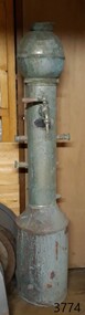
Functional object - Water Boiler, Jackson Boilers Ltd, 1920s
Jackson Boilers Ltd., brass founders, electro platers and sheet metal works made this tube water boiler. It was a fitting in the vessel Reginald M, a small cargo ship built at Port Adelaide in 1922 and named after her builder and first owner, John Murch. The Reginald M was launched at Largs Bay, South Australia, in 1922 to carry cargo around South Australia that included guano, barley, wool, horses, cattle, timber, explosives, potatoes, shell grit, and gypsum. It passed through numerous owners over the years and primarily maintained its purpose as a cargo vessel. In 1975, the decommissioned Reginald M was purchased by Flagstaff Hill Maritime Museum as an attraction. Although restoration efforts were undertaken and maintained for the craft above the water line, deterioration occurred below the surface and resulted in the ship being unsafe for visitors to board. It was broken up and removed from Flagstaff Hill in 2018, but items such as the historical boiler remain in Flagstaff Hill’s Collection. JACKSON BOILERS LTD.: - In 1911, Henry Jackson was the Managing Director at Jackson Boilers Ltd. He had gained around 30 years’ experience as a tin plate worker, plumber and gas fitter at Ilkey in 1881, then at Leeds by 1901. By 1921, he had changed employment from Jackson Boilers to Managing Director of Patent Water Boilers. During World War I, Jackson Boilers Ltd of Leeds performed war work like many other manufacturers at that time. The firm made cases for the explosive picric acid and electroplated fuse hole plugs. In 1918, the firm employed 15 males and 19 females. Jacksons Boilers became very successful throughout the first half of the twentieth century with showrooms and sales offices in Scotland, the Midlands and Southern England. It also had an office in Dublin, Ireland. In the post-war 1920s, the firm’s production included instantaneous water boilers and coffee machines for cafes, restaurants and canteens. Jackson Boilers also began to supply shipping lines with catering water boilers for their ships. The firm applied for a USA patent for the tube boiler in 1930, for the design which appears to have been invented in 1926. A 1971 advertisement adds the credentials, Members of the Catering Equipment Manufacturers’ Association. The tube water boiler was designed specifically for use in a ship's restaurant or dining area and patented by Jackson Boilers Ltd. of Leeds. The boiler is significant as a patented design, illustrating the evolution of maritime, commercial and domestic water boilers that have led to many innervations and improvements in today's boilers that are used in heating and in producing hot water for domestic and catering use. It is also significant as it is one of the earlier boilers the Jackson company made in the early 1920s before they applied for a US patent on their revised design in 1926.Water boiler, free standing Jackson's Tube boiler. A tall metal cylindrical stand with a metal sphere on top and several pipe fittings on the sides. A brass tap with a lever handle is connected to the front. A plaque with maker's details is attached under the tap. Details are also impressed into the cylinder above the tap.Jackson Boilers Leeds Ltd. "JACKSON'S PATENT" . Other details indecipherable. flagstaff hill maritime museum and village, flagstaff hill maritime museum, flagstaff hill, maritime museum, maritime village, warrnambool, great ocean road, leeds, jackson boilers ltd, jackson boilers, henry jackson, brass founders, electro platers, sheet metal works, patent water boilers, leeds manufacturer, tube water boiler, domestic boiler, tube domestic boiler, tube boiler, water heaters, water boilers, self-feeding water boilers, sheet metal work instantaneous water heaters, engineering, allied trades, metal workers, metal trade, food machinery, hospitality equipment, ship equipment, ship water boiler, ship heater, catering boilers, café boiler, restaurant boiler, canteen boiler, catering equipment manufacturers’ association, cema, kitchen equipment, kitchen appliance, war work, world war i, wwi, picric acid, picric acid cases, fuse hole plugs, electro plated fuse hole plugs, reginald m, cargo ship, port adelaide, 1922, john murch -
 The Beechworth Burke Museum
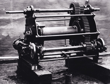
Photograph - Photograph - Reproduction, c.1870s
This photograph shows a piece of gold mining equipment identified as a mine winch, possibly an air winch cylinder of 1870s RG Ford's Patent design. Throughout the history of mining for gold and other precious materials, the windlass or winch (pictured) was used to bring up buckets full of soil from the bottom of a mine. This soil was then searched for gold/metals before being relocated to a different area. Due to the size and complexity of this particular piece of equipment, this winch may have been used to raise and lower mine carts to the entrance of the mine (often used in coal mining) and could have been used in raising cages up and down (acting as elevators) containing miners if the mine was particularly deep. The actual use of this particular item in the Beechworth locality is undocumented but these are some possibilities based on the use of these pieces of equipment in other mining locations. Mining can have a largely detrimental impact to the environment and therefore, the study of machinery like the one depicted in this photograph can help researches to reconstruct the methods and technologies used in the late 1800s and early 1900s. This particular item appears to have been removed from it's original site where it would have been used to assist with mining. It is possible that this photograph has been taken for recording purposes or as part of a machinery exhibition. Prior documentation records that this piece of equipment had connections to the Rocky Mountains Mining Company. Today, the Rocky Mountains Gold Mining company is famous in Beechworth for having been instrumental in the creation of the Rocky Mountain tunnel. Construction for this tunnel began in 1859 when a group of 12 men blasted a 400ft long tailrace though the rock beneath the town of Beechworth. Today, the 800ft tunnel, completed in 1871, is a popular tourist attraction but during the decades of gold mining, the purpose of this tunnel was to divert water away from the main sluicing operations so miners could better access gold and precious materials. The tunnel was used for this purpose for many years, later becoming useful for the Zwar Brother's tannery and currently as an outfall drain for Lake Sambell. This area continued to be mined until the early 1900s. The period when this item was in use is unclear but it is estimated to have been in the 1870s based on the design and appearance of the image. The gold works at the Rocky Mountain Tunnel closed in the early 1920s but the impact of mining remains in Beechworth today and therefore the study of photographs like this one which contain mining equipment can further understanding of mining in this region.This photograph has historic and research potential for study on the gold mining of the Beechworth region and types of equipment used to locate gold after the initial gold rush of 1853-1854 which resulted in the discovery of the surface gold and required miners to dig deeper to access precious metals. The clarity of the photo, and its good preserved condition, means it can continue to be used for research. This photo is part of a collection of six photos all within the Burke Museum Collection which depict mining equipment.Square black and white photograph on card.7793.1beechworth, mining, goldmining, goldmining equipment, beechworth burke museum -
 Flagstaff Hill Maritime Museum and Village
Machine - Pulley Sheave, Circa 1886
The pulley sheave comes from the Falls of Halladale, a four-masted iron-hulled barque that was built in 1886 for the long-distance bulk carrier trade. The vessel was built for the Falls Line (Wright, Breakenridge & Co., Glasgow, Scotland) at the shipyard of Russell & Co., Greenock on the River Clyde, she was named after a waterfall on the Halladale River in the Caithness district of Scotland. The ship's design was advanced for her time, incorporating features that improved crew safety and efficiency such as elevated bridges to allow the crew to move between forward and aft in relative safety during heavy seas. The Falls of Halladale was the seventh vessel in a series of eight similar iron-hulled sailing ships, all built by Russell & Co and all named after waterfalls in Scotland. The Falls of Halladale was preceded by the Falls of Clyde (1878), the Falls of Bruar (1879), the Falls of Dee (1882), the Falls of Afton (1882), the Falls of Foyers (1883) and the Falls of Earn (1884). The Falls of Halladale was followed by a sister ship, the Falls of Garry (1886). The Falls of Clyde is afloat today and is a major attraction at the Hawaii Maritime Center in Honolulu. The Falls of Halladale is best known for her spectacular demise in a shipwreck near Peterborough, Victoria on the shipwreck coast of Victoria, Australia. On the night of 14 November 1908, she was sailed in dense fog directly onto the rocks due to a navigational error. The crew of 29 abandoned ship safely and all made it ashore by boat, leaving the ship foundering with her sails set. For weeks after the wreck, large crowds gathered to view the ship as she gradually broke up and then sank in the shallow water. Soon after the accident the ship's master, Capt. David Wood Thomson was brought before a Court of Marine Inquiry in Melbourne and found guilty of a gross act of misconduct, having carelessly navigated the ship, having neglected to take proper soundings, and having failed to place the ship on a port tack before it became too late to avoid the shipwreck. Capt. Thomson's punishment included a small fine and he had his Certificate of Competency as a Master suspended for six months. Today the Falls of Halladale is a popular destination for recreational divers. The wreck is easily accessible by scuba divers about 300 m offshore in 3 to 15 m of water. The hull lies on its collapsed starboard side. Some of the original cargo of 56,763 roof slates remains at the site of the wreck along with corroded masses of what used to be coils of barbed wire. Twenty-two thousand slates were salvaged in the 1980s and used to provide roofing at the Flagstaff Hill Maritime Village in Warrnambool. An anchor that was recovered in 1974 is on display at the village. The pulley sheave is significant as a salvaged item from the Victorian heritage-listed Falls of Halladale wreck. As an artifact from the wrecked ship, it helps us to remember today the story of the wrecking and is an important reminder of a marine incident in Victoria's maritime history. Wooden Pulley Sheave from the vessel Falls of HalladaleNoneflagstaff hill, warrnambool, shipwrecked-coast, flagstaff-hill, flagstaff-hill-maritime-museum, maritime-museum, shipwreck-coast, flagstaff-hill-maritime-village, wooden pulley sheave, falls of halladale -
 Flagstaff Hill Maritime Museum and Village
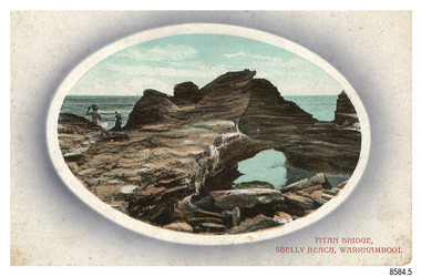
Postcard - Scenic, Warrnambool, Titan Bridge, Shelly Beach, Warrnambool, 1902-1929
The nine postcards in this set were donated together and date to the early 1900s. All but one postcard in this set shows images of Warrnambool, in the Western District of Victoria; the other has a London image. The postcards were all printed in Great Britain according to that country’s postal regulations. The fronts of all cards have titles printed in red. Most of the images on the cards are attributed to photographer Joseph Jordan and belong to the Jordan Series. The back of these cards has an outline for a postage stamp, a vertical dividing line and a heading on each side of the line to separate the Correspondence from the Address. Postcards or ‘correspondence cards’ appeared in Britain in 1894. They were plain cards with a space for the message on one side and an address on the other; regulations didn’t allow anything but the address to be written on the ‘address’ side. In 1902 the British regulations then allowed a picture to be printed on the front and the address on the back, so messages had to be written on the picture side. Soon, the regulations changed and the back was divided for a message and the address. Titan Bridge, Warrnambool – The name Titan Bridge is likely to be a reference to the huge Titan crane that was used in the construction of the Breakwater in the late 19th century. Shelly Beach is a popular swimming area with the added attraction of rock pools to investigate and rock formations to climb. Joseph Jordan - Joseph Jordan was born in 1841 in Leicester England. When he was 16 he joined the 7th Queen's Own Hussars and was sent to India at the outbreak of the mutiny. He took part in the relief of Lucknow and remained in India for eleven years. It was during this time that he became interested in photography. He was posted to New Zealand and later came to Victoria, becoming a sergeant major of the Mounted Rifles. In the mid-1880s he came to the Western district where he was responsible for establishing units of the Mounted Rifles in various country towns such as Dunkeld, Mortlake, Panmure, Bushfield, Koroit etc. He resigned from the army in 1889 and set up a professional photography studio in Liebig Street, Warrnambool. He became very well known in the Western District for family photographs, official photographs of local councillors and groups as well as views of local scenery. In 1891 he photographed the wrecked barque ‘Fiji’ at ‘Wrecks Beach’ near Princetown. His business was taken over by his son Arthur around 1917. Joseph was a keen rifle shot and in 1924 he donated the "Jordan Shield" as a prize to the Victorian Rifle Association. He was made a "Life Honorary Member" of the Warrnambool Returned Soldiers League and in 1933 he was recognised as being the oldest living soldier in Victoria. Joseph died in 1935 aged 95.The image of the Titan Bridge rock formation with figures on it suggests that the location was a popular place to visit. It captures a time when the rock formation was publically accessible. The choice of subject for this postcard indicates the popularity of Warrnambool's natural environment as a tourist attraction at a time when ships called coastal traders brought passengers and cargo to the Port of Warrnambool from ports along Victoria's southwest coast. Joseph Jordan is a significant figure in Warrnambool history as he helped to establish early units of the Mounted Rifles (G Company) in local towns during the late 1880's and later, photographed local scenes, groups and citizens of early Warrnambool.Postcard, one of nine, landscape orientation, coloured print within an oval border and mauve-toned shading. The cameo image shows two figures, one seated and one standing, beside the sea on a rough rock beside a rock formation resembling a bridge. There is no correspondence written on the card. The back has inscriptions and outlines for a postage stamp. Jordan Series, printed in Great Britain.Front, in red: “TITAN BRIDGE / SHELLY BEACH, NEAR WARRNAMBOOL” Back in black: “Jordan Series” “POST CARD” “PRINTED IN GREAT BRITAIN” “For correspondence” “The Address only to be written here”flagstaff hill maritime museum, flagstaff hill maritime village, flagstaff hill maritime museum and village, maritime museum, warrnambool, great ocean road, warrnambool and district, warrnambool scenes, local scenes, views of warrnambool, joseph jordan, jordan series, jordan photography, postcard, souvenir, correspondence, cameo postcard, landscape, shelly beach, titan bridge, titan, rock formation -
 Flagstaff Hill Maritime Museum and Village
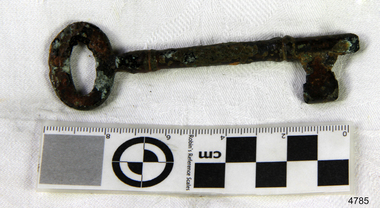
Functional object - Key, 1886
The key was recovered from the Falls of Halladale, a four-masted iron-hulled barque that was built in 1886 for the long-distance bulk carrier trade. The vessel was built for the Falls Line (Wright, Breakenridge & Co., Glasgow, Scotland) at the shipyard of Russell & Co., Greenock on the River Clyde, she was named after a waterfall on the Halladale River in the Caithness district of Scotland. The ship's design was advanced for her time, incorporating features that improved crew safety and efficiency such as elevated bridges to allow the crew to move between forward and aft in relative safety during heavy seas. The Falls of Halladale was the seventh vessel in a series of eight similar iron-hulled sailing ships, all built by Russell & Co and all named after waterfalls in Scotland. The Falls of Halladale was preceded by the Falls of Clyde (1878), the Falls of Bruar (1879), the Falls of Dee (1882), the Falls of Afton (1882), the Falls of Foyers (1883) and the Falls of Earn (1884). The Falls of Halladale was followed by a sister ship, the Falls of Garry (1886). The Falls of Clyde is afloat today and is a major attraction at the Hawaii Maritime Centre in Honolulu. The Falls of Halladale is best known for her spectacular demise in a shipwreck near Peterborough, Victoria on the shipwreck coast of Victoria, Australia. On the night of 14 November 1908, she was sailed in dense fog directly onto the rocks due to a navigational error. The crew of 29 abandoned ship safely and all made it ashore by boat, leaving the ship foundering with her sails set. For weeks after the wreck, large crowds gathered to view the ship as she gradually broke up and then sank in the shallow water. Soon after the accident the ship's master, Capt. David Wood Thomson was brought before a Court of Marine Inquiry in Melbourne and found guilty of a gross act of misconduct, having carelessly navigated the ship, having neglected to take proper soundings, and having failed to place the ship on a port tack before it became too late to avoid the shipwreck. Capt. Thomson's punishment included a small fine and he had his Certificate of Competency as a Master suspended for six months. Today the Falls of Halladale is a popular destination for recreational divers. The wreck is easily accessible by scuba divers about 300 m offshore in 3 to 15 m of water. The hull lies on its collapsed starboard side. Some of the original cargo of 56,763 roof slates remains at the site of the wreck along with corroded masses of what used to be coils of barbed wire. Twenty-two thousand slates were salvaged in the 1980s and used to provide roofing at the Flagstaff Hill Maritime Village in Warrnambool. An anchor that was recovered in 1974 is on display at the village. The key is significant as a salvaged item from the Victorian heritage-listed Falls of Halladale wreck. As an artifact from the wrecked ship, it helps us to remember today the story of the wrecking and is an important reminder of a marine incident in Victoria's maritime history. KeyNoneflagstaff hill, warrnambool, shipwrecked coast, flagstaff hill maritime museum, maritime museum, shipwreck coast, flagstaff hill maritime village, great ocean road, falls of halladale, shipwreck peterborough, 1908 shipwreck, great clipper ships, russell & co., key -
 Flagstaff Hill Maritime Museum and Village
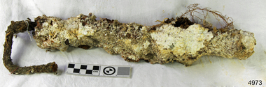
Functional object - Rope
The encrusted rope probably used on rigging comes from the Falls of Halladale, a four-masted iron-hulled barque that was built in 1886 for the long-distance bulk carrier trade. The vessel was built for the Falls Line (Wright, Breakenridge & Co., Glasgow, Scotland) at the shipyard of Russell & Co., Greenock on the River Clyde, she was named after a waterfall on the Halladale River in the Caithness district of Scotland. The ship's design was advanced for her time, incorporating features that improved crew safety and efficiency such as elevated bridges to allow the crew to move between forward and aft in relative safety during heavy seas. The Falls of Halladale was the seventh vessel in a series of eight similar iron-hulled sailing ships, all built by Russell & Co and all named after waterfalls in Scotland. The Falls of Halladale was preceded by the Falls of Clyde (1878), the Falls of Bruar (1879), the Falls of Dee (1882), the Falls of Afton (1882), the Falls of Foyers (1883) and the Falls of Earn (1884). The Falls of Halladale was followed by a sister ship, the Falls of Garry (1886). The Falls of Clyde is afloat today and is a major attraction at the Hawaii Maritime Centre in Honolulu. The Falls of Halladale is best known for her spectacular demise in a shipwreck near Peterborough, Victoria on the shipwreck coast of Victoria, Australia. On the night of 14 November 1908, she was sailed in dense fog directly onto the rocks due to a navigational error. The crew of 29 abandoned ship safely and all made it ashore by boat, leaving the ship foundering with her sails set. For weeks after the wreck, large crowds gathered to view the ship as she gradually broke up and then sank in the shallow water. Soon after the accident the ship's master, Capt. David Wood Thomson was brought before a Court of Marine Inquiry in Melbourne and found guilty of a gross act of misconduct, having carelessly navigated the ship, having neglected to take proper soundings, and having failed to place the ship on a port tack before it became too late to avoid the shipwreck. Capt. Thomson's punishment included a small fine and he had his Certificate of Competency as a Master suspended for six months. Today the Falls of Halladale is a popular destination for recreational divers. The wreck is easily accessible by scuba divers about 300 m offshore in 3 to 15 m of water. The hull lies on its collapsed starboard side. Some of the original cargo of 56,763 roof slates remains at the site of the wreck along with corroded masses of what used to be coils of barbed wire. Twenty-two thousand slates were salvaged in the 1980s and used to provide roofing at the Flagstaff Hill Maritime Village in Warrnambool. An anchor that was recovered in 1974 is on display at the village. The encrusted rope is significant as a salvaged item from the Victorian heritage-listed Falls of Halladale wreck. As an artifact from the wrecked ship, it helps us to remember today the story of the wrecking and is an important reminder of a marine incident in Victoria's maritime history.Piece of encrusted rope. Artifact Reg No FoH/1.Noneflagstaff hill, warrnambool, shipwrecked coast, flagstaff hill maritime museum, maritime museum, shipwreck coast, flagstaff hill maritime village, great ocean road, falls of halladale, shipwreck peterborough, 1908 shipwreck, great clipper ships, russell & co., rope -
 Flagstaff Hill Maritime Museum and Village
Machine - Pulley Sheave, Circa 1886
The pulley sheave comes from the Falls of Halladale, a four-masted iron-hulled barque that was built in 1886 for the long-distance bulk carrier trade. The vessel was built for the Falls Line (Wright, Breakenridge & Co., Glasgow, Scotland) at the shipyard of Russell & Co., Greenock on the River Clyde, she was named after a waterfall on the Halladale River in the Caithness district of Scotland. The ship's design was advanced for her time, incorporating features that improved crew safety and efficiency such as elevated bridges to allow the crew to move between forward and aft in relative safety during heavy seas. The Falls of Halladale was the seventh vessel in a series of eight similar iron-hulled sailing ships, all built by Russell & Co and all named after waterfalls in Scotland. The Falls of Halladale was preceded by the Falls of Clyde (1878), the Falls of Bruar (1879), the Falls of Dee (1882), the Falls of Afton (1882), the Falls of Foyers (1883) and the Falls of Earn (1884). The Falls of Halladale was followed by a sister ship, the Falls of Garry (1886). The Falls of Clyde is afloat today and is a major attraction at the Hawaii Maritime Center in Honolulu. The Falls of Halladale is best known for her spectacular demise in a shipwreck near Peterborough, Victoria on the shipwreck coast of Victoria, Australia. On the night of 14 November 1908, she was sailed in dense fog directly onto the rocks due to a navigational error. The crew of 29 abandoned ship safely and all made it ashore by boat, leaving the ship foundering with her sails set. For weeks after the wreck, large crowds gathered to view the ship as she gradually broke up and then sank in the shallow water. Soon after the accident the ship's master, Capt. David Wood Thomson was brought before a Court of Marine Inquiry in Melbourne and found guilty of a gross act of misconduct, having carelessly navigated the ship, having neglected to take proper soundings, and having failed to place the ship on a port tack before it became too late to avoid the shipwreck. Capt. Thomson's punishment included a small fine and he had his Certificate of Competency as a Master suspended for six months. Today the Falls of Halladale is a popular destination for recreational divers. The wreck is easily accessible by scuba divers about 300 m offshore in 3 to 15 m of water. The hull lies on its collapsed starboard side. Some of the original cargo of 56,763 roof slates remains at the site of the wreck along with corroded masses of what used to be coils of barbed wire. Twenty-two thousand slates were salvaged in the 1980s and used to provide roofing at the Flagstaff Hill Maritime Village in Warrnambool. An anchor that was recovered in 1974 is on display at the village. The pulley sheave is significant as a salvaged item from the Victorian heritage-listed Falls of Halladale wreck. As an artifact from the wrecked ship, it helps us to remember today the story of the wrecking and is an important reminder of a marine incident in Victoria's maritime history. Wooden Pulley Sheave from the vessel, Falls of HalladaleNoneflagstaff hill, warrnambool, shipwrecked-coast, flagstaff-hill, flagstaff-hill-maritime-museum, maritime-museum, shipwreck-coast, flagstaff-hill-maritime-village, wooden pulley sheave, falls of halladale -
 Flagstaff Hill Maritime Museum and Village
Functional object - Vent Cover, circa 1886
The vent cover comes from the Falls of Halladale, a four-masted iron-hulled barque built in 1886 for the long-distance bulk carrier trade. The vessel was built for the Falls Line (Wright, Breakenridge & Co., Glasgow, Scotland) at the shipyard of Russell & Co., Greenock on the River Clyde, she was named after a waterfall on the Halladale River in the Caithness district of Scotland. The ship's design was advanced for her time, incorporating features that improved crew safety and efficiency such as elevated bridges to allow the crew to move between forward and aft in relative safety during heavy seas. The Falls of Halladale was the seventh vessel in a series of eight similar iron-hulled sailing ships, all built by Russell & Co and all named after waterfalls in Scotland. The Falls of Halladale was preceded by the Falls of Clyde (1878), the Falls of Bruar (1879), the Falls of Dee (1882), the Falls of Afton (1882), the Falls of Foyers (1883) and the Falls of Earn (1884). The Falls of Halladale was followed by a sister ship, the Falls of Garry (1886). The Falls of Clyde is afloat today and is a major attraction at the Hawaii Maritime Center in Honolulu. The Falls of Halladale is best known for her spectacular demise in a shipwreck near Peterborough, Victoria on the shipwreck coast of Victoria, Australia. On the night of 14 November 1908, she was sailed in dense fog directly onto the rocks due to a navigational error. The crew of 29 abandoned ship safely and all made it ashore by boat, leaving the ship foundering with her sails set. For weeks after the wreck, large crowds gathered to view the ship as she gradually broke up and then sank in the shallow water. Soon after the accident the ship's master, Capt. David Wood Thomson was brought before a Court of Marine Inquiry in Melbourne and found guilty of a gross act of misconduct, having carelessly navigated the ship, having neglected to take proper soundings, and having failed to place the ship on a port tack before it became too late to avoid the shipwreck. Capt. Thomson's punishment included a small fine and he had his Certificate of Competency as a Master suspended for six months. Today the Falls of Halladale is a popular destination for recreational divers. The wreck is easily accessible by scuba divers about 300 m offshore in 3 to 15 m of water. The hull lies on its collapsed starboard side. Some of the original cargo of 56,763 roof slates remains at the wreck's site along with corroded masses of what used to be coils of barbed wire. Twenty-two thousand slates were salvaged in the 1980s and used to provide roofing at the Flagstaff Hill Maritime Village in Warrnambool. An anchor that was recovered in 1974 is on display in the village. The pulley sheave is significant as a salvaged item from the Victorian heritage-listed Falls of Halladale wreck. As an artifact from the wrecked ship, it helps us to remember today the story of the wrecking and is an important reminder of a marine incident in Victoria's maritime history. Vent cover taken from the top of an iron Bollard. Recovered from the wreck of the Falls of Halladale. noneflagstaff hill, warrnambool, shipwrecked-coast, flagstaff-hill, flagstaff-hill-maritime-museum, maritime-museum, shipwreck-coast, flagstaff-hill-maritime-village, vent cover, falls of halladale, russell & co. -
Bendigo Historical Society Inc.
Newspaper - Albert Ernest Richardson, Peter Anderson's article 2020
Albert Richardson was born on 22nd. June, 1902 to George Albert Richardson and Catherine Agnes (nee Flynn). He married Mavis Irene Yarwood on 23rd. December, 1931. Albert Richardson's childhood activities in Duncan Street, Long Gully, were influenced strongly by the occupation of his father and grandfather, both of whom were engine drivers on the Bendigo field. Albert had his own model goldmine, complete with poppet head, baling tanks etc and was up and ready to start work with the sound of the 7 a.m. mine whistles. Albert spent a short time working as a motor mechanic and then took up0 welling insurance with T & G. However, his heart was with the mines and he worked daytimes with T. & G. and then took off to learn engine driving with night shift in one of the mines. He gained his engine drivers' ticket in 1938 and began work at the Nell Gwynne. His longest work time was at the North Nell but he also had shorter spells at other mines. His leter work years were spent at John Brown, from where he retired in 1968. Albert had a deep regard for the working man and worked for many years in the position of Secretary at the Trades Hall, Bendigo. (adapted from biography in BHS Collection, written by I. Hendry, 1972) The Bendigo Historical Society holds a wide range of Bendigo mining records researched and written by Mr. Albert Richardson. He was President of the Bendigo Branch of the Royal Historical Society of Victoria from 1969 to 1971.When he joined the Bendigo Branch in 1966 he began compiling a history of the Bendigo mines. He spent many long hours researching at the Bendigo Mines Department, summarising mine records. He gathered relevant mining material wherever it could be obtained. He devoted most of his spare time and energy to the Society, conducting tours of the goldfields, writing articles and presenting talks to various organisations. His first and foremost interest lay in Victoria Hill. He examined mining reports and early newspaper articles to document its history. He envisaged the once fabulously rich hill as becoming a tourist attraction and campaigned vigorously to achieve this. In 1971 his dream was realised, when, with the help of South Bendigo Rotary Club 'The Hill' was cleaned up and historical site4s sign-posted. In 1972 the Bendigo Trust produced a booklet on Victoria Hill. Albert Richardson is acknowledged as the person ' on whose work and writings the text of this booklet has been based' The park adjoining Victoria Hill was named the Albert Richardson Reserve in his honour. Four newspaper clippings on mining, focusing on Albert Richardson's life; his passion for mining history and more generally, the work of engine drivers on the Bendigo goldfield. Clippings taken from the 'Bendigo Weekly' 2016, dated September 29 'Learner Drivers' , October 7 'Becoming qualified', October 14 'Steam power in his veins' and November 11 ' Victoria Hill over the decades'. All articles written by James Lerk in a series titled 'Discover Bendigo'. albert richardson, engine driver, mining, bendigo, boiler, engine room, mining cage, albert richardson reserve, victoria hill, george ellis, south bendigo rotary club -
 Eltham District Historical Society Inc
Photograph, Shire of Eltham War Memorial, Memorial Park, Garden Hill, Kangaroo Ground; Eltham Heritage Tour, 24 May 1992, 24/05/1992
ELTHAM HERITAGE TOUR The Society excursion on 24th May 1992 was arranged by David Bick, leader of the team carrying out the Shire's heritage study. David selected a number of sites or buildings identified in the study, some of them lesser known components of the Shire's heritage. The tour commenced at the Eltham Shire Office at 10.00 am. Travel was by private car and mini-bus with stops at about twelve locations for commentary by David.It included a short walk in Hurstbridge and lunch at Kinglake. Highlights of the tour included: - 10 am Leave from Shire Offices - 3 Important Trees - A Physical Link to Eltham's First Settlers - Toorak Mansion Gates - A Surviving Farm House - An Intact Circa 1900 Main Street - First Settlers - Gold Miners, and Timber-getters - An Early Hotel - A Pioneering Homestead - Changing Eltham Shire - 20th Century - 4 pm Afternoon Tea and Finish Tour Extract from ELTHAM CULTURAL HERITAGE TOUR (Newsletter No. 85, July 1992, by Bettina Woodburn) "Now we drove through stands of pines to the Kangaroo Ground Lookout Tower, a most unusual War Memorial, World War I. The tower and a shed/residence (it had a chimney) were built from local sandstone. Below to the south and east of Melbourne spread 'suburbia'. Close by the landscape seemed so contrived - English fields and hedgerows! Although only about twenty inches deep, the soil of this ancient volcano, its crater lost under subsequent weathering, was rich, deserving the name of "Garden Hill". Now native trees are taking over again. In Kangaroo Ground itself stand the inevitable Store, School and Church - and two Norfolk pines and a monkey puzzle tree." On November 11th 1926 the Shire of Eltham War Memorial Tower at Kangaroo Ground was opened. It is regarded as one of Melbourne’s most outstanding lookout towers. It commands a magnificent 360 degree panorama from Kinglake across the Diamond Valley to Macedon and the You Yangs. It is built on a peak which was once a volcano, 237 metres above sea level. After World War one a memorial cairn was erected on the site, and in 1925 a committee of public-minded citizens began to plan for a tower. Many generous donations of material and money were forthcoming so that in 1926 the Governor General Lord Stonehaven was able to unveil the plaque before a crowd of 500 people. There was some concern in the 1960s when the Forests Commission wanted to build a firespotters cabin on the top. At first R.S.L. branches opposed the idea, but it was realised that this use could combine with its use as a tourist attraction, and would ensure its maintenance for the future, Today the Kangaroo Ground tower provides one of the best views around Melbourne and is a fitting memorial to those who died in two world wars. From: Historic items for Diamond Valley Community Radio September 1990 (EDHS collection) Record of the Society's history and activities and highlighting various aspects of the Heritage Study undertaken by David Bick used to create the future heritage overlay for the Shire of Eltham and later Nillumbik Shire.Roll of 35mm colour negative film, 4 stripsKodak Gold 100 5095culture, events, garden hill, kangaroo ground, kangaroo ground memorial, memorial park, shire of eltham war memorial tower, war memorials