Showing 841 items
matching board of works
-
 Port Melbourne Historical & Preservation Society
Card - Water supply to shipping, MMBW
... Melbourne and Metropolitan Board of Works 'Water Supply... in compactus transport - shipping Melbourne and Metropolitan Board ...Found in compactusMelbourne and Metropolitan Board of Works 'Water Supply to Shipping' cardtransport - shipping -
 Melbourne Legacy
Letter - Document, letter
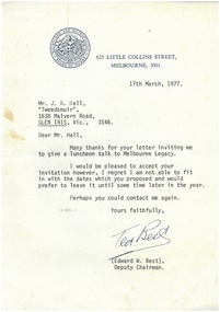
... and Metropolitan Board of Works letterhead.... on Melbourne and Metropolitan Board of Works letterhead. Letter ...Letter from Ted Best to J.R. Hall thanking him for the opportunity to speak at a Legacy Luncheon. Legatees met regularly and had guest speakers to entertain and inform on different subjects at their Tuesday Luncheons. This document was from a file of information about guest speakers (see also 00812-00822 and 00829-00837). The Programme Committee was responsible for organising the speakers. A record that the speakers at Legacy functions were from very different walks of life and the subjects spoken on were many and varied. Pale blue, notepaper, type letter on Melbourne and Metropolitan Board of Works letterhead.Signed by Ted W. Best (Deputy Chairman of the board) in blue ink.speakers, committee -
 Eltham District Historical Society Inc
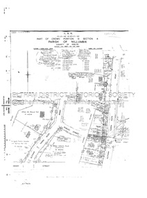
Document - Survey Plan, Country Roads Board, SP 6801, Eltham-Yarra Glen Road; Brougham St to Bridge St, 1958
... Board of Land & Works.... & C.G.H. Fitzpatrick Board of Land & Works Bridge Street Brougham ...1958 C.R.B. Plan of Survey of Part of Crown Portion 12 Section 4 Parish of Nillumbik, County of Evelyn Eltham-Yarra Glen Road, Shire of Eltham Shows Surveyor field notes, property ownership and building type and construction.a.j. collis, a.s. & c.g.h. fitzpatrick, board of land & works, bridge street, brougham steet, commonwealth bank of australia, country roads board, eltham, eltham rsl sub-branch, f.h. collis, f.m. smith, f.n. & e.j. burgoyne, franklin street, h.c. & r.e. burgoyne, j. jorgenson, j.f. & j.e. morris, j.n. & h.c. burgoyne, j.s. blow, john street, main road, p.e. smith, pitt street, r.j. dripps, s.j. taylor, survey plan, trustees of the eltham methodist church, 1958, eltham-yarra glen road, neil webster collection -
 Eltham District Historical Society Inc
Document - Survey Plan, Country Roads Board, SP 6313, Eltham-Yarra Glen Road; Luck St to Henry St, 1956
... The Board of Land & Works... Street The Board of Land & Works The Equity Trustees Executors ...1956 C.R.B. Plan of Survey of Part of Crown Portion 13 Section 4 Parish of Nillumbik, County of Evelyn Eltham-Yarra Glen Road, Shire of Eltham Shows Surveyor field notes, property ownership and building type and construction.eltham-yarra glen road, country roads board, eltham, main road, survey plan, 1956, a.l. lyon, a.w. brinkkotter, arthur street, c.r. burkett, dudley street, e.n. staff, eltham war memorial trust, henry street, luck street, pryor street, the board of land & works, the equity trustees executors and agency coy ltd, the roman catholic trusts corporation, victorian railways commision, neil webster collection -
 Eltham District Historical Society Inc
Document - Survey Plan, Country Roads Board, SP 6559-6560, Eltham-Yarra Glen Road; Elsa Ct to Luck St, 1957
... The Board of Land & Works... R.N. Mowatt The Board of Land & Works W.G. Hains Neil Webster ...1957 C.R.B. Plan of Survey of Part of Crown Portion 13 Section 4 and Crown Allotment 1 Section 1 Parish of Nillumbik, County of Evelyn Eltham-Yarra Glen Road, Shire of Eltham Shows Surveyor field notes, property ownership and building type and construction.eltham-yarra glen road, country roads board, eltham, main road, survey plan, 1957, a.m. & a.a. iowerson, a.mcg. hepburn, cecil street, coffee lounge, diamond street, e.g. murrell, elsa court, h.b. woodhead, j.c. & s.i. harding, la ronde, luck street, r.m. & v.m. white, r.n. mowatt, the board of land & works, w.g. hains, neil webster collection -
 Bendigo Historical Society Inc.
Document - JOSEPH MARTIN BRADY: DOCUMENTATION, 2004
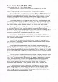
... Brisbane Board of Water Works... Harbour Trust Bendigo Water Works Brisbane Board of Water Works ...Joseph Martin Brady documentation - two pages - life history - written by Geoff Russell 2004. With 5 item bibliography. Also - page on Brady from internet (but bad copy - printed on portrait, not landscape)Geoff Russellperson, individual, joseph martin brady, sir john coode, melbourne harbour trust, bendigo water works, brisbane board of water works, victorias north eastern railway. queensland first engineer of harbours & rivers. joseph brady. -
 Whitehorse Historical Society Inc.
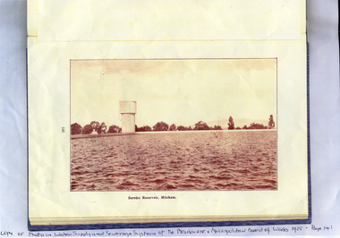
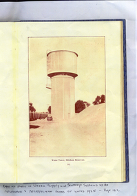
Photograph, Mitcham Reservoir
... and Metropolitan Board of Works - 1925... of the Melbourne and Metropolitan Board of Works - 1925 Mitcham Reservoir ...The Mitcham Reservoir was commenced in 1921 and completed in 1923. The capacity was 43,000,000 gallonsSepia-toned copy of a photograph of the Mitcham reservoir taken from 'Water Supply and Sewerage Systems of the Melbourne and Metropolitan Board of Works - 1925mitcham reservoir, water supply -
Whitehorse Historical Society Inc.
Article, More Child Care Places, 1991
... in conjunction with the Melbourne and Metropolitan Board of Works... is to be developed in conjunction with the Melbourne and Metropolitan Board ...More people will have access to Nunawading City Council child care centres.More people will have access to Nunawading City Council child care centres. A fifth centre is to be developed in conjunction with the Melbourne and Metropolitan Board of Works. With photo.More people will have access to Nunawading City Council child care centres.child care, city of nunawading, fisher, barbara, bertino, kim -
 Whitehorse Historical Society Inc.
Photograph, Mitcham Reservoir
... and Sewerage Systems of Melbourne and Metropolitan Board of Works... and Metropolitan Board of Works - 1925' Mitcham Reservoir Photograph ...Sepia-toned copy of a photo of the water tower at the Mitcham Reservoir. Taken from page 142 of the 'Water Supply and Sewerage Systems of Melbourne and Metropolitan Board of Works - 1925'mitcham reservoir, water supply -
 Ringwood and District Historical Society
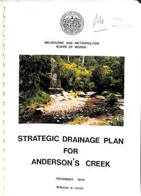
Book, Strategic Drainage Plan For Anderson's Creek, 1978
... Melbourne and Metropolitan Board of Works 1988 report..., M.M.B.W. Chairman. Melbourne and Metropolitan Board of Works 1988 ...Melbourne and Metropolitan Board of Works 1988 report on physical characteristics of Anderson's Creek and development of management strategies formulated in consultation with Cities of Croydon, Doncaster & Templestowe, and Ringwood, in which the Anderson's Creek Basin is located. Foreword by Alan H. Croxford, M.M.B.W. Chairman. -
 Ringwood and District Historical Society
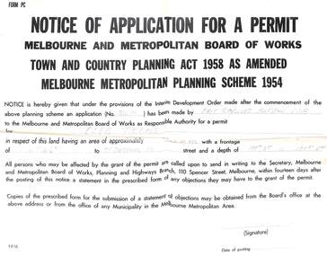
Work on paper - Application for Permit, Application for Permit, ERFC New Clubrooms Sept 1962
... Melbourne and Metropolitan Board of Works permit (form TP16... Road Ringwood North melbourne Melbourne and Metropolitan Board ...Poster-size cardboard notice, with pin holes.Melbourne and Metropolitan Board of Works permit (form TP16) to commence an application for the East Ringwood Football Club new clubrooms. Signed by Jim Burke, Secretary of the ERFC, in September 1962 -
Marysville & District Historical Society
Article (item) - Book extract, Unknown
... board of land and works.... mohican station board of land and works acheron station niagaroon ...A book extract from an unknown publication.A book extract from an unknown publication.mohican station, board of land and works, acheron station, niagaroon station, r brough smyth, robert hickson, john green, goulburn district, wurunjeri, yarra river, rev r hamilton, illustrated australian news 25 august 1865, coranderrk, central board, woori yaloak, upper yarra, woori yaloak reserve, hoddles creek, woori yaloak creek -
 Bayside Gallery - Bayside City Council Art & Heritage Collection
Map, Department of Lands and Survey, Land under the control of the City of Sandringham, 1962
... Board of Lands and Works... moorabbin black rock street map City of Sandringham Board of Lands ...The cadastral map showing land under the control of the City of Brighton in 1962.map, plan, foreshores, sndringham, hampton, beaumaris, cheltenham, department of lands and survey, cartographic material, moorabbin, black rock, street map, city of sandringham, board of lands and works -
Whitehorse Historical Society Inc.
Map, Municipality of Nunawading, c1950
... at the Melbourne and Metropolitan Board of Works under the direction of G.R... and Metropolitan Board of Works under the direction of G.R. McGowan, Chief ...Plan No 234, compiled and photo-lithographed at the Melbourne and Metropolitan Board of Works under the direction of G.R. McGowan, Chief Surveyor.Plan No 234, compiled and photo-lithographed at the Melbourne and Metropolitan Board of Works under the direction of G.R. McGowan, Chief Surveyor. Covers the area each Side of Canterbury Road from Orchard Grove to Vernon Street. Includes detail of creeks.Plan No 234, compiled and photo-lithographed at the Melbourne and Metropolitan Board of Works under the direction of G.R. McGowan, Chief Surveyor. blackburn south, gardiners creek, blackburn, blackburn creeklands -
 Whitehorse Historical Society Inc.
Report, 'Mitcham Toc H Destroyed by Fire', 19/03/1960
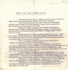
... by fire of their 'log hut' on the Board of Works property in Agra... hut' on the Board of Works property in Agra Street. Toc H ...Information on Mitcham branch of Toc H suffering the loss by fire of their 'log hut' on the Board of Works property in Agra Street. Toc H is nondenominational and the local branch gives practical help to needy persons in the community. Members hope to commence rebuilding and resume full operations.toc h mitcham branch;, service clubs -
Port Melbourne Historical & Preservation Society
Plan - Ingles Street, Port Melbourne, 12 Jan 1866
... Melbourne and Metropolitan Board of Works (MMBW)..., Port Melbourne Melbourne and Metropolitan Board of Works (MMBW) ...Plans for Ingles Street showing both ground plan and longitudinal and traverse sections at Station Place, Heath, Nott and Bay Streets.Signed by surveyor Chas. Clay and James Bibby plus Thomas (Reek) Warren as witness to latter sig. Also a no: 355/H1 added later.engineering - roads streets lanes and footpaths, charles clay, thomas (reek) warren, james bibby -
 Kew Historical Society Inc
Photograph - Kew Main Drain, 1984
... of Kew, Ian Poulter, by the Supervising Engineer (Works... & Metropolitan Board of Works. The record includes an image ...'Kew, Kew East, Balwyn & Balwyn North are located approximately 7km north east of Melbourne. Four main stormwater drains service the area flowing from south to north. Three of the drains: Deepdene Drain; Balwyn Drain & Glass Creek converge in Kew East just west of Burke Road at Kew High School before discharging into the Yarra River. The fourth drain, Kew Main Drain connects directly with the Yarra River to the West of Glass Creek.' The Kew Main Drain is a barrel drain that was created in the 1930s, and follows the route of the former Connor's Creek from the vicinity of Genazzano FCJ College to the Yarra River in East KewImportant and verifiable evidence of the construction methods used by the Melbourne & Metropolitan Board of Works in building the Kew Main Drain, before its reconstruction in c.1985.Original print colour positive photograph of the Kew Main Drain, provided on 14/12.84 to the Chief Engineer of the City of Kew, Ian Poulter, by the Supervising Engineer (Works), Southern and Eastern Drainage, Melbourne & Metropolitan Board of Works. The record includes an image of the reverse as well as the donation document from the MMBW."A84/1855-9 / 750mm council drain looking D/S [down stream] and across Parkhill Road. To be replaced with 1200 mm R.C.P. [reinforced concrete pipe] as part of MMBW Kew Main Drain reconstruction works"kew main drain, stormwater drains -- kew (vic.), connor's creek -- kew (vic.) -
 Kew Historical Society Inc
Photograph - Kew Main Drain, 1984
... of Kew, Ian Poulter, by the Supervising Engineer (Works... & Metropolitan Board of Works. The record includes an image ...'Kew, Kew East, Balwyn & Balwyn North are located approximately 7km north east of Melbourne. Four main stormwater drains service the area flowing from south to north. Three of the drains: Deepdene Drain; Balwyn Drain & Glass Creek converge in Kew East just west of Burke Road at Kew High School before discharging into the Yarra River. The fourth drain, Kew Main Drain connects directly with the Yarra River to the West of Glass Creek.' The Kew Main Drain is a barrel drain that was created in the 1930s, and follows the route of the former Connor's Creek from the vicinity of Genazzano FCJ College to the Yarra River in East KewImportant and verifiable evidence of the construction methods used by the Melbourne & Metropolitan Board of Works in building the Kew Main Drain, before its reconstruction in c.1985.Original print colour positive photograph of the Kew Main Drain, provided on 14/12.84 to the Chief Engineer of the City of Kew, Ian Poulter, by the Supervising Engineer (Works), Southern and Eastern Drainage, Melbourne & Metropolitan Board of Works. The record includes an image of the reverse as well as the donation document from the MMBW."A84/1855-10 / 750mm council drain looking U/S [up stream] from Parkhill Road, Kew."kew main drain, stormwater drains -- kew (vic.), connor's creek -- kew (vic.) -
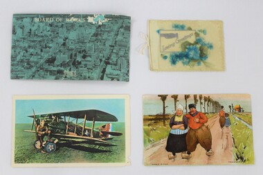 Wodonga & District Historical Society Inc
Postcard - Haeusler Collection Postcards and Greeting Card c. Mid-Century
... a photograph of a city with text reading "Board of Works" overlaid... depict a photograph of a city with text reading "Board of Works ...The Wodonga Historical Society Haeusler Collection provides invaluable insight into life in late nineteenth and early twentieth century north east Victoria. The collection comprises manuscripts, personal artefacts used by the Haeusler family on their farm in Wodonga, and a set of glass negatives which offer a unique visual snapshot of the domestic and social lives of the Haeusler family and local Wodonga community. The Haeusler family migrated from Prussia (Germany) to South Australia in the 1840s and 1850s, before purchasing 100 acres of Crown Land made available under the Victorian Lands Act 1862 (also known as ‘Duffy’s Land Act’) in 1866 in what is now Wodonga West. The Haeusler family were one of several German families to migrate from South Australia to Wodonga in the 1860s. This item has well documented provenance and a known owner. It forms part of a significant and representative historical collection which reflects the local history of Wodonga. It contributes to our understanding of domestic and family life in early twentieth century Wodonga, as well as providing interpretative capacity for themes including local history and social history.Three postcards and one greeting card. The postcards depict a photograph of a city with text reading "Board of Works" overlaid; a man posing with an early 1900s airplane; and an illustrated cartoon man and woman walking on a road in a rural area in Europe. The greeting card has text that reads "Loving Greetings" and a raised floral bouquet design made of plastic.haeusler collection, wodonga, postcards, postcard, post, mail, airplane, greeting cards -
 Whitehorse Historical Society Inc.
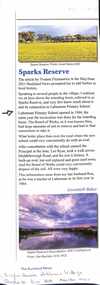
Article, Sparks Reserve, Nov/Dec 2021
... The Board of Works established a retarding basin known... Mitcham melbourne The Board of Works established a retarding basin ...An article about Sparks Reserve Retarding Basin and Laburnum Primary School ovalnon-fictionAn article about Sparks Reserve Retarding Basin and Laburnum Primary School ovalsparks reserve, retarding basin, laburnum primary school no 4863, fitzmaurice yvonne, baker gwennyth -
 Myrtleford and District Historical Society
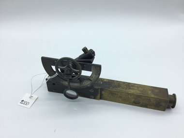
Inclinometer, Early 20th Century
... Board of Works. Item has been in the possession of Terry... Metropolitan Board of Works. Item has been in the possession of Terry ...Provenance not clear. Leather case has 'MMBW' inscribed in black pen, indicating an association with Melbourne Metropolitan Board of Works. Item has been in the possession of Terry McCormack since 1972Hand held brass pocket inclonometer level, circa 1920. Leather case for safe storage. Semi circular graduated dial with 90 degree vernier scale with a small (20mm) magnifying glass to aid reading the vernier scale. Above the body, mounted at the rear of the graduated dial, is a spirit level tube which is tilted by finger movement to the milled hand wheel. The height to be determined is sighted through the instrument eyepiece and the bubble tube is tilted until the bubble, viewed in the mirror inside the sighting tube, is brought level with the graticule sighted at the top of the subject object. An angle is thus obtained and by measuring the distance on the ground to the object, trigonometry can be applied to determine the height of the object.Herga & Co. BRISBANE. Made in England -
 Southern Sherbrooke Historical Society Inc.
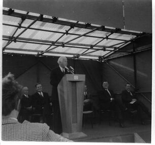
Photograph - Cardinia Reservoir's official works opening ceremony 1970
... & Metropolitan Board of Works. ... & Metropolitan Board of Works. Photograph Cardinia Reservoir's official ...Black and white photo of the opening ceremony to mark the beginning of works at Cardinia Reservoir, May 1970. The official party is seated on a small podium beneath a temporary marquee. The Governor of Victoria, Sir Rohan Delacombe, is addressing the audience from behind a wooden podium. Seated behind him are several men including Alan Croxford, then Chairman of the Melbourne & Metropolitan Board of Works. -
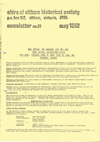 Eltham District Historical Society Inc
Newsletter, Newsletter, No. 24 May 1982
... Contents: • Next meeting – Film night: Featuring Board...Contents: • Next meeting – Film night: Featuring Board ...Contents: • Next meeting – Film night: Featuring Board of Works films of local and historical interest • Subscriptions • Annual General Meeting • Williamstown trip • Former Falkiner House, Ely Street, Eltham The Shire of Eltham Historical Society was formed in October 1967. The first newsletter of the Society was issued May 1978 and has been published continuously ever since on a bi-monthly basis. With the cessation of the Shire of Eltham in late 1994, the Society's name was revised to Eltham District Historical Society and this name first appeared with issue No. 103, July 1995. The collection of the Society's newsletters provides a valuable resource on the history of the Society's activities, office bearers and committee members, guest speakers and subjects of historical interest pertinent to the former Shire of Eltham and the Eltham District.A4 photocopied newsletter distributed to membersnewsletter, eltham district historical society, shire of eltham historical society -
 Ringwood and District Historical Society
Document - Plan of Subdivision, Part of Crown Allotment 31B, Parish of Warrandyte - 1965
... easement. Levels are to Board of Works Datum. Lot number 3 has been... easement. Levels are to Board of Works Datum. Lot number 3 has been ...Map showing residential allotments numbered 1, 2, 4 and 5, on Through Road, Ringwood, Vic., with property dimensions, including weatherboard house and galvanised iron garage on lot 2.Kirkpatrick & Webber, Licensed Surveyors, Civil Engineers & Town Planners, Maroondah Highway, Ringwood, Telephone 8700321. Ref 3438C. Date 4th December, 1964. Amended 19th July, 1965. Notation: "The land coloured blue is a drainage and sewerage easement. Levels are to Board of Works Datum. Lot number 3 has been omitted." -
 Greensborough Historical Society
Book, Isabel Ellender, The Plenty Valley Corridor: the archaeological survey of Aboriginal sites / by Isabel Ellender 1991, 1991_
... was conducted by Isabel Ellender in 1991 for the Board of Works... for the Board of Works (Melbourne Water), in particular the Plenty Gorge ...This archaeological survey of the Plenty Valley was conducted by Isabel Ellender in 1991 for the Board of Works (Melbourne Water), in particular the Plenty Gorge Metropolitan Park. The area studied is north of Greensborough to Whittlesea. A number of Aboriginal sites were identified and recommendations made for the future.67 p., illus., maps. Plastic spiral binding.plenty river, aboriginal heritage sites, plenty gorge metropolitan park -
 Kew Historical Society Inc
Plan - Subdivision Plan, High Street, Kew, 1920-1935
... allotment facing Mary Street. In 1906, when the Board of Works... the Board of Works surveyors completed Detail Plan 1589 ...Pru Sanderson, in her groundbreaking ‘City of Kew Urban Conservation Study : Volume 2 - Development History’ (1988), summarised the periods of urban development and subdivisions of land in Kew. The periods that she identified included 1845-1880, 1880-1893, 1893-1921, 1921-1933, 1933-1943, and Post-War Development. These periods were selected as they represented periods of rapid growth or decline in urban development. An obvious starting point for Sanderson’s groupings involved population growth and the associated economic cycles. These cycles also highlighted urban expansion onto land that was predominantly rural, although in other cases it represented the decline and breakup of large estates. A number of the plans in the Kew Historical Society’s collection can also be found in other collections, such as those of the State Library of Victoria and the Boroondara Library Service. A number are however unique to the collection.The Kew Historical Society collection includes almost 100 subdivision plans pertaining to suburbs of the City of Melbourne. Most of these are of Kew, Kew East or Studley Park, although a smaller number are plans of Camberwell, Deepdene, Balwyn and Hawthorn. It is believed that the majority of the plans were gifted to the Society by persons connected with the real estate firm - J. R. Mathers and McMillan, 136 Cotham Road, Kew. The Plans in the collection are rarely in pristine form, being working plans on which the agent would write notes and record lots sold and the prices of these. The subdivision plans are historically significant examples of the growth of urban Melbourne from the beginning of the 20th Century up until the 1980s. A number of the plans are double-sided and often include a photograph on the reverse. A number of the latter are by noted photographers such as J.E. Barnes.A roughly drawn and faded actual or projected subdivision of a parcel of land bordering on High and Mary Streets. The plan shows five allotments facing High Street and at their rear, another allotment facing Mary Street. In 1906, when the Board of Works surveyors completed Detail Plan 1589, the allotment in Mary Street is shown to include a building. The section of land attached to this building is shown to be undeveloped, thus making a further subdivision possible.subdivision plans - kew, high street -- kew (vic.), mary street -- kew (vic.) -
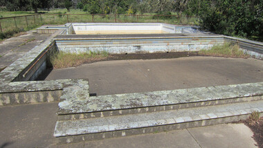 Ballarat Heritage Services
digital photographs, Lisa Gervasoni, Cocoroc pre olympic pool, c2010-2017
... In 1892 the Melbourne and Metropolitan Board of Works... Office goldfields In 1892 the Melbourne and Metropolitan Board ...In 1892 the Melbourne and Metropolitan Board of Works established the Metropolitan Sewage Farm on the western bank of the Werribee River, to treat the effluent from Melbourne's new sewerage system.This area was isolated and too far from Melbourne, so the Cocoroc village was built to house the workers.Colour photograph of the Cocoroc Swimming Pool. This pool was built by the town's residents.swimming pool, sport, swimming, pre olympic, concrete, cocoroc, cocoroc swimming pool -
 Whitehorse Historical Society Inc.
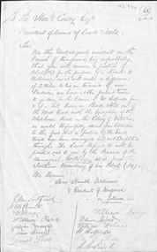
Letter - Correspondence, Roads, n.d
... Request from 'Residents of Ringwood' to President of Board... 'Residents of Ringwood' to President of Board of Lands & Works ...Request from 'Residents of Ringwood' to President of Board of Lands & Works, the Hon. Mr Casey for provision of a road alternative to 'Blood's Hill ' route. Signed by J. M. Setford and others. n.d.roads and streets, setford, j.m., ringwood, clements, a.b., blazey, w.r., parr, william, maggs, joseph, morriss, james, burge, william, holmes, william, hatfield, h., leach, g.w. -
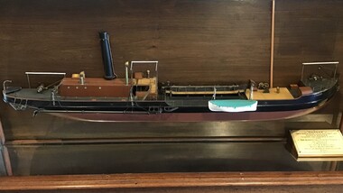 Queenscliffe Maritime Museum
Leisure object - Model Boat Pioneer
... for the Victorian Dept of Board of Works in 1905. The Pioneer was scuttled... in Glasgow, Scotland for the Victorian Dept of Board of Works in 1905 ...SS Pioneer was a steam dredging ship which was in service with the Department of Ports & Harbours, Melbourne, Australia, from 1905 to 1950. The Pioneer (aka SS Pioneer) was a steel steam driven pump driven sand dredge. She was built in Glasgow, Scotland for the Victorian Dept of Board of Works in 1905. The Pioneer was scuttled on 9 March 1950.Half model of suction dredge Pioneer in glass display casemodel, sand dredger, ss pioneer, port of melbourne -
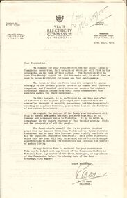 Bendigo Historical Society Inc.
Document - MERLE BUSH COLLECTION: VARIOUS DOCS
... to Stockholders; Power Loans ; Cash and Conversion Loans 1954/55; b. Board... and Conversion Loans 1954/55; b. Board of Works Cash Loan Prospectus 1956 ...Various docs (possibly from Bush Collection?) a. Public issue of State Electricity Commission securities - letter to Stockholders; Power Loans ; Cash and Conversion Loans 1954/55; b. Board of Works Cash Loan Prospectus 1956; c. Card with information re the MMBW Metropolitan Farm; d. two B&W interior photos of St. Davids church, Hobart; e. J C Williamson Magazine programme 1934; f. Melbourne & Metropolitan Tramways Board -map of proposals for General Scheme 1923.ephemera, mementoes, general interest