Showing 8342 items matching "bridges"
-
 Phillip Island and District Historical Society Inc.
Photograph, 1968
... Bridges ...Part of an album compiled and donated by Mrs Helen Jansson. Second Phillip Island Bridge built 1968/69.Bridge viewed from sea level at low tide, showing cranes at middle right.local history, photography, photographs, slides, film, civil engineering, bridges, phillip island bridges, black & white photograph, mrs helen jansson, phillip island bridge -
Tatura Irrigation & Wartime Camps Museum
Photograph, Clark D, 1989
Waranga Basin commenced in 1902Black and white photograph of Waranga - Mallee channel, flowing under bridge on Tatura - Rushworth road.on back - Bridge over Waranga - Mallee channelwaranga basin -
 Lakes Entrance Historical Society
Photograph - Swan Reach Bridge, 1926 c
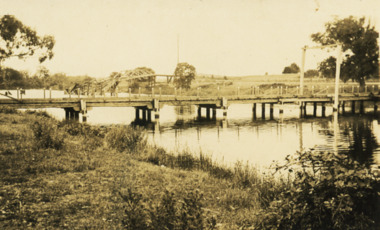
... Bridges ...Black and white photograph of temporary bridge at Swan Reach collapsed highway bridge in background Swan Reach Victoriawaterways, bridges -
 Lakes Entrance Historical Society
Postcard - First concrete bridge over North Arm Lakes Entrance Victoria, H D Bulmer, 1920 c
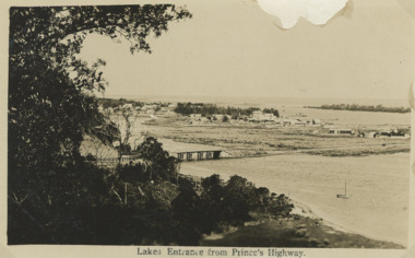
... Bridges ...First concrete bridge over North Arm swamp land behind buildings on Esplanade low sand dunes on outer barrier Lakes Entrance VictoriaBlack and white postcard of township showing first concrete bridge over North Arm swamp land behind buildings on Esplanade low sand dunes on outer barrier Lakes Entrance VictoriaLakes Entrance from Princes Highwayislands, roads and streets, bridges, township -
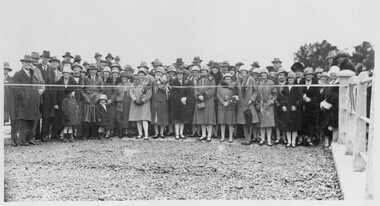
 Phillip Island and District Historical Society Inc.
Photograph, Phillip Island Bridge Opening, 1969
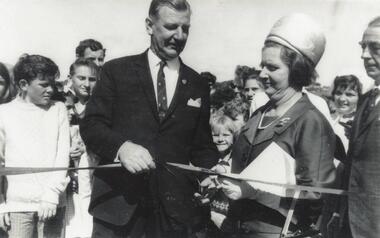
... bridges ...Official Opening of 2nd Bridge, 1969, connecting San Remo and Newhaven. From the Jack Jenner Collection.Close up of Hon. Porter & Mrs Porter cutting ribbon at Opening of Bridge. Children & other spectators in background.local history, photographs, civil engineering, bridges, opening of phillip island bridge, black & white photograph, jack jenner collection, phillip island bridges, public construction -
 Kew Historical Society Inc
Photograph - Zig-Zag Bridge, 1924
Henry Beater Christian (1886-1962) , was a descendant of one of the earliest settler families in Kew. Employed at the Kew Asylum as a 'public servant', he was a skilled amateur photographer, photographing numerous scenes in Kew and on his travels around Victoria. The majority of his photographs date from 1916 to 1929. His finest photographs are housed in two photograph albums. Digital copy of a photograph from page 8 of the 47-page photograph album containing 261 gelatinous silver images, loaned by Diane Washfold with permission given to digitise and hold a copy in our collection. The Zig-Zag Bridge linked the grounds of the Yarra Bend and Kew Asylums. The wooden bridge was constructed in the 1870s and lasted through numerous floods until its destruction in 1929. A horizontal structure, the walkway was reached via a wooden staircase on the Kew bank of the river. The steps were required due to the different levels of the banks on this stretch of the river. The photo is taken from the Kew side of the river and shows clearly the width of the walkway on top of the bridge. "Zig-Zag Bridge"henry beater christian (1886-1962), landscape photography, kew (vic.) — yarra river, christian-washfold collection, photograph albums, zig-zag bridge -
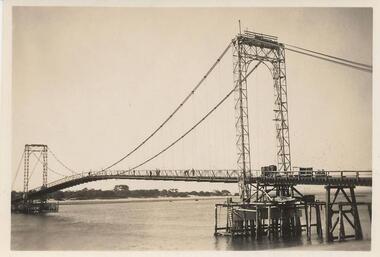 Phillip Island and District Historical Society Inc.
Photograph, 1939-40
... bridges ...Part of a collection presented by Miss Edith Elms via Chrisy Northcote. 1st Phillip Island Bridge built 1939-40, connecting the Island to San Remo.Close up of 1st Bridge with Suspension in place. Decking under construction. Scaffolding and works in progress underneath near side.local history, photography, photographs, bridges, phillip island, san remo, sepia photograph -
 Linton and District Historical Society Inc
Photograph, Opening of Bridge over Woady Yaloak Creek, between Linton and Scarsdale, 1928, 1928
Black and white photograph of a crowd of men, women and children standing behind a ribbon stretched between sets of bridge rails."Opening of bridge between Linton and Scarsdale".events, bridge openings, woady yaloak creek, faull collection -
 Eltham District Historical Society Inc
Photograph, Doug Orford, Bridge Street Bridge, Eltham
... bridges ...Two colour photographs of Bridge Street Bridge over Diamond Creek, Eltham showing bridge sub-structurebridges, diamond creek, eltham, bridge street -
 Eltham District Historical Society Inc
Photograph, Doug Orford, Bridge Street Bridge, Eltham
... bridges ...Two colour photographs of Bridge Street Bridge over Diamond Creek, Eltham showing bridge sub-structurebridges, diamond creek, eltham, bridge street -
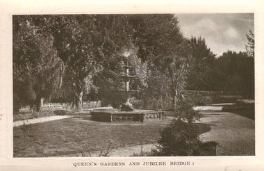 Clunes Museum
Photograph
CLUNES QUEEN'S PARK GARDEN'S.1 ORIGINAL POSTCARD OF CLUNES QUEEN'S GARDEN. FOUNTAIN IN THE FOREGROUND. JUBILEE BRIDGE IN THE BACKGROUND .2 PHOTOCOPY OF POSTCARD .3 ENLARGED PHOTOCOPY OF POSTCARDQUEEN'S GARDENS AND JUBILEE BRIDGE.postcard, queen's park garden -
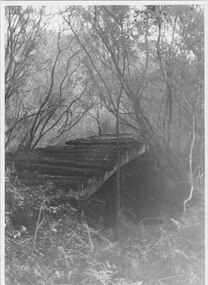
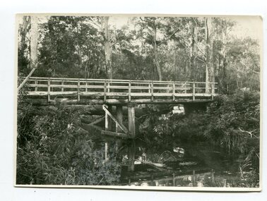 Orbost & District Historical Society
black and white photograph, June 1897
This photograph was taken at what is now the Young’s Creek picnic area which is located on the site of an old sawmill, once owned and operated by L.E. & H. Williams, dating back to the early 1920’s. The mill was eventually sold, dismantled, and the machinery transferred to a sawmill at Cabbage Tree Creek. there are still some items of old sawmill debris. The old steam engine at the edge of the car park is the remains of the mill’s former power plant. This portable steam engine was constructed in Leiston, Suffolk, in England.This is a pictorial record of a popular recreational area in the Orbost district in the late 19th century.A black / white photograph of a wooden bridge over a creek in forest setting. There is a second copy.on back - handwritten "the Young's Creek Bridge June 1897"young's-creek-orbost bridge-young's-creek -
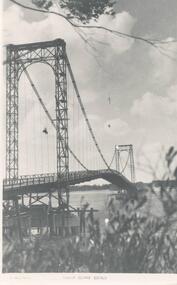
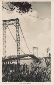 Phillip Island and District Historical Society Inc.
Photograph - Post Card, A. J. Murray, c 1950
Postcard donated by Brenda HumphreysBlack & White postcard of the Phillip Island Suspension Bridge main span taken from San RemoPhoto Shop Series Phillip Island Bridge.suspention bridge, phillip island suspention bridge, brenda humphreys -
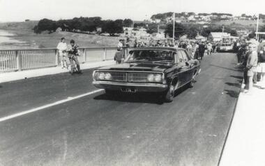 Phillip Island and District Historical Society Inc.
Photograph, Phillip Island Bridge Opening, 1969
... bridges ...First traffic across 2nd Bridge, 1969, between Sand Remo & Newhaven, after official opening ceremony. From the Jack Jenner Collection.Minister's Car driving across newly opened Bridge between San Remo & Phillip Island 1969.local history, photographs, civil engineering, bridges, opening of phillip island bridge, black & white photograph, jack jenner collection, phillip island bridges, public construction -
 Stawell Historical Society Inc
Photograph, Greens Creek Bridge on the Wimmera River 1929
Greens Creek Bridge on the Wimmera River built in 1929 by C.R.B. and now demolished. The replacement bridge was designed to cope with the floods and the approaches to the new bridge were built up. This photo is a copy of a negative owned by the society.Black and white photograph of a concrete road bridge over a creek. Red gum trees in the background. Two concrete supports remain of old bridge on bank behind new bridge.stawell -
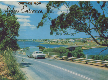 Lakes Entrance Historical Society
Postcard - Views of Lakes Entrance c1972, 1972 c
... Bridges ...Princes Highway looking down to North Arm bridge with town in distance, people camped on North Arm foreshore and car towing caravan in foreground Lakes Entrance VictoriaColour postcard taken from Princes Highway looking down to North Arm bridge with town in distance, people camped on North Arm foreshore and car towing caravan in foreground Lakes Entrance VictoriaGreetings from Lakes Entrancebridges, roads and streets, township, vehicles -
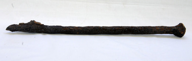 Orbost & District Historical Society
bridge spike
This spike came from the old Brodribb River bridge which is about 9.6 kilometres from Orbost. The Brodribb River joins the Snowy River north of Marlo. In 1906, a bridge replaced the punt over the Brodribb River, improving communication with Orbost. It was eventually replaced by a reinforced concrete bridge built by the Road Construction Authority in 1989 where the Princes Highway passes over the Brodribb RiverThis item belongs to a significant local structure which has been replaced.A very rusty iron bridge spike from the old Brodribb Bridge.brodribb-river bridge-spike -
 Orbost & District Historical Society
black and white photograph, 1918
Tonghi Creek is 66km north - west of Orbost. Prior to the sealing of the Princes Highway west of Orbost, the road surface was anything but good, even by C1917 when cars started to use the road. From Orbost the old road via Marlo to Sydenham was abandoned for the new location which traversed more rugged country via Cabbage Tree, Bell Bird and Club Terrace to Cann River, and the reason for this diversion was on account of settlements being established at Murrungowar and Club Terrace, at which latter place there was a temporary rush to obtain gold. This road was constructed by the Public Works department and a maximum grade of 1 in 19 was adopted, and as speed was not to be catered for the grade followed in and out round the spurs and gullies, resulting in a maze of turns and twists which required a good deal of skill on the part of the horse driver to negotiate." - Bairnsdale Advertiser, Friday, May 2, 1947. (More information from Newsletter February 2010)This item is a pictorial record of roads in the early 20th century in East Gippsland.A large black / white photograph of a bridge over a small creek, surrounded by bush. The photograph is mounted on a thick cream coloured card.on back - "Bridge at Tonghi Creek 1918"tonghi-creek-bridge country-roads-east-gippsland -
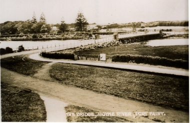 Port Fairy Historical Society Museum and Archives
Postcard, Valentine Publishing Co, The Bridge Moyne River Pt Fairy, 10.04.1929
Black and white Photograph of the bridge crossing the Moyne river with Gipps street in the foreground cleared land in the background taken for use as a postcardThe Bridge Moyne River Pt Fairymoyne bridge circa 1930, bridge, moyne river, river, road -
Phillip Island and District Historical Society Inc.
Photograph
... Bridges ...Phillip Island suspension Bridge built 1938/40. First road connection with mainland at San Remo - demolished 1970. Part of an album compiled and donated by Mrs Helen Jansson.Print of San Remo approach to Phillip Island Bridge with cars and compressor at middle.local history, photography, photographs, slides, film, civil engineering, bridges, phillip island bridge, black & white photograph, mrs helen jansson, phillip island bridge -
![The Fairfield Bridge [circa 1891]](/media/collectors/550653872162f11fb04854aa/items/579eab98d0cdd117c4af1c89/item-media/579eac23d0cdd117c4afb1ad/item-fit-380x285.jpg) Kew Historical Society Inc
Kew Historical Society IncPrint, The Fairfield Bridge [circa 1891], c. 1891
This work forms part of the collection assembled by the historian Dorothy Rogers, that was donated to the Kew Historical Society by her son John Rogers in 2015. The manuscripts, photographs, maps, and documents were sourced by her from both family and local collections or produced as references for her print publications. Many were directly used by Rogers in writing ‘Lovely Old Homes of Kew’ (1961) and 'A History of Kew' (1973), or the numerous articles on local history that she produced for suburban newspapers. Most of the photographs in the collection include detailed annotations in her hand. The Rogers Collection provides a comprehensive insight into the working habits of a historian in the 1960s and 1970s. Together it forms the largest privately-donated collection within the archives of the Kew Historical Society.A reproduction of a photograph of the Fairfield Bridge. The bridge was one of the first constructed for the Outer Circle Railway in 1891. Its supervising engineer was [Sir] John Monash. The bridge was later to be repurposed as a road linking the Chandler Highway to Fairfield."Outer Circle Railway Bridge over River Yarra at Fairfield (last section of line opened 1891)"fairfield bridge, chandler highway bridge, dorothy rogers, john monash, outer circle railway -
 Halls Gap & Grampians Historical Society
Photograph - B/W
... Bridges ...Photo shows old rail bridge, surrounded by bush & passing over what appears to be a creek. Bridge is supported by wooden trestles. structures, bridges -
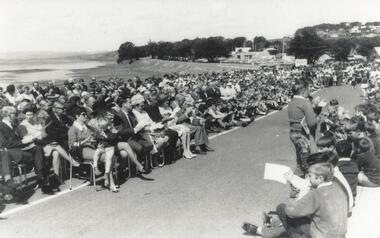 Phillip Island and District Historical Society Inc.
Photograph, Phillip Island Bridge Opening, 1969
... bridges ...Official Opening of 2nd San Remo - Newhaven Bridge, 1969 by Hon. Porter, Minister of Public Works. From the Jack Jenner Collection.Large crowd, some seated, on road approach to New Bridge San Remo side, on day of Opening 1969.local history, photographs, civil engineering, bridges, phillip island bridge, black & white photograph, jack jenner collection, phillip island bridges, public construction -
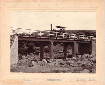 Hume City Civic Collection
Photograph
... bridges ...Chris. Christiansen had a barber shop in Sunbury and was the photographer in the town from 1895 until 1916. He conducted his business in a building situated on the corner of Evans and Brooks Streets. The Gillies Bridge is situated on the Wildwood Road, just off the Lancefield Road.A mounted sepia photograph of the Gillies Bridge at Sunbury. The mounting is cream with silver writing across the bottom of the photograph. There is a man driving a steam roller (traction engine) across the bridge and another man is standing at the bottom of the bridge on the RHS. The creek and rocks are in the foreground. Cream mounting - 2 cm wide with silver inscriptionsChristiansen / Sunbury Studiosgillies bridge, wildwood road, sunbury, bridges, steam rollers, bulldozers, tractors, christiansen, chris, photographers, george evans collection -
 Stawell Historical Society Inc
Slide, Ian McCann, Finishing Touches
... Bridges ...A Man painting the new Concrete Bridge.bridges, campbells bridge -
 Phillip Island and District Historical Society Inc.
Photograph, Suspension Bridge, 1940's
Donated by John JanssonBlack & White photograph of the San Remo to Newhaven Bridge taken from San Remo in foreground to Newhaven in background."Photo Shop Series" "Phillip Island Bridge"phillip island bridge, john jansson -
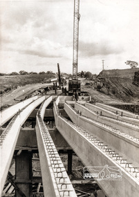 Eltham District Historical Society Inc
Photograph, Construction of Lower Plenty Bridge, Main Road, c.August 1966, 1966
... bridges ...This black and white photograph records construction activity of the then new Main Road bridge over the Plenty River at Lower Plenty in 1969.Local significanceBlack and white photograph taken during construction of the Main Road bridge over the Plenty River. Includes structural members, construction personnel, vehicles and a Clarke mobile crane.mobile cranes, bridge construction, main road, plenty river, lower plenty, bridges -
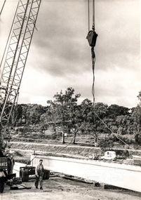
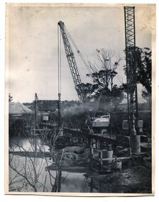 Orbost & District Historical Society
black and white photographs, 1975
These are photographs of the construction of the current cement road bridge across the Snowy River at Orbost. Construction of the bridges commenced in January 1975, with an expectation to open the bridge across the Snowy River as soon as possible. Less than two years later, on 25 November 1976, the bridge across the Snowy River was opened to traffic, allowing the old bridge to be demolished. The remainder of the Orbost Bypass, both the floodplain crossings and the eastern section around the township itself, was declared ‘Princes Freeway’ and opened to traffic in December 1977. (ref http://mrv.ozroads.com.au)The opening of this Snowy River Bridge was an important development in the accessibility to the township of Orbost. These photographs record its construction.Two black / white photographs showing the construction of a road bridge across a river. 3257.1 shows piles being dropped beside the bridge, 3257.2 is of the early stages of construction of this bridge.snowy-river-bridge-orbost road-construction-orbost bridge-orbost -
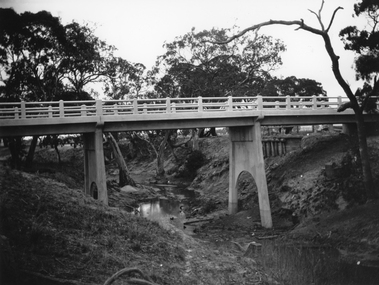
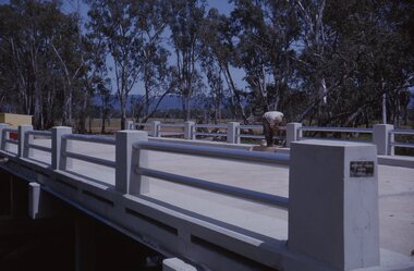
 Ringwood and District Historical Society
Photograph, Mullum Mullum Creek new bridge work commences. Warrandyte Road, Ringwood - 1986
Start of new bridge, Warrandyte Rd. Ringwood 1986 (2 views)Written on back of photograph, "Start of new bridge, Warrandyte Rd. 1986."